Sustainable Development
of Kansas Water Resources
Kansans have long struggled with the best way to manage the state’s
water. A new bulletin from the Kansas Geological Survey questions some
of the traditional ways decisions about water have been made.
The bulletin, Perspectives on Sustainable Development of Water Resources
in Kansas, points out flaws in a traditional management concept known
as safe yield. Edited by Survey geohydrologist Marios Sophocleous, the
bulletin’s 11 chapters describe the complexities of the water system
and explore issues of safe yield and sustainability. In addition to chapters
on Kansas water resources and sustainability issues, the book includes
chapters on water chemistry, agriculture, and climate change.
Copies of Bulletin 239, Perspectives on Sustainable Development of
Water Resources in Kansas, are available from the KGS for $25.00
plus tax, shipping, and handling.
Kansas Sand Dunes
Sand dunes in south-central Kansas formed within the last 1,000 years,
much more recently than previously thought. That means the land where
the dunes are located is susceptible to even small changes in climate,
according to a new bulletin published by the Kansas Geological Survey.
The bulletin, Late Quaternary Paleoenvironments and Landscape Evolution
on the Great Bend Sand Prairie, by Alan Arbogast, demonstrates that
dunes on the Great Bend Sand Prairie formed in the last 1,000 years during
extended periods of drought in a climate very similar to today’s.
The Great Bend Sand Prairie lies south of the sweeping bend in the Arkansas
River and covers 1,100 square miles in Stafford, Barton, Edwards, Kiowa,
Pratt, Reno, and Rice counties.
Copies of Bulletin 242, Late Quaternary Paleoenvironments and Landscape
Evolution on the Great Bend Sand Prairie, are available from the
KGS for $12.50 plus tax, shipping, and handling.
Kansas Geologic Names
Keeping track of the countless names of Kansas rock units is no easy task.
A new bulletin from the Kansas Geological Survey, Lexicon of Geologic
Names of Kansas (through 1995), edited by D. L. Baars and Christopher
G. Maples, is a compilation of names that are used or have been used in
the past by geologists working in the state.
Compiled by Kansas Geological Survey stratigraphers, this alphabetical
listing of stratigraphic names in Kansas distinguishes valid names from
improper and informal terms. Names are defined briefly as to lithology,
thickness, age, underlying and overlying units, and type locality and/or
reference section. A nomenclatural history of each term is provided, as
many of the names have been redefined and modified.
Copies of Lexicon of Geologic Names of Kansas (through 1995)
(Bulletin 231) can be ordered from the KGS for $25.00 plus tax, shipping,
and handling.
Online Journal Highlights Current Research
The latest article in the Survey’s online journal demonstrates the
applicability of ground-penetrating radar to the search for petroleum
reservoirs. The article, Utility of Ground-penetrating Radar in Near-surface,
High-resolution Imaging of Lansing-Kansas City (Pennsylvanian) Limestone
Reservoir Analogs, by Alex Martinez, Joseph M. Kruger, and Evan K.
Franseen, was published in September 1998. It is the final article in
this year’s issue of Current Research in Earth Sciences.
This article, along with previously published articles in the Current
Research bulletin, can be viewed at www.kgs.ku.edu/Current.
The two other articles published this year are Allostratigraphic and
Sedimentologic Applications of Trace Fossils to the Study of Incised Estuarine
Valleys: An Example from the Virgilian Tonganoxie Sandstone Member of
Eastern Kansas, by L. A. Buatois, M. G. Mángano,
C. G. Maples, and W. P. Lanier, and Distribution of the Bandera Shale
of the Marmaton Group, Middle Pennsylvanian of Southeastern Kansas,
by R. L. Brownfield, R. L. Brenner, and J. P. Pope.
A printed version of Bulletin 241, Current Research in Earth Sciences, will be available from Publication Sales at the Kansas Geological Survey in late 1998.
New
Publications
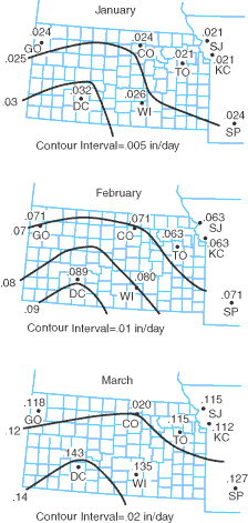
Penman's potential evapotranspiration average daily estimates by month in inches per day (from Bulletin 239).
URL:http://www.kgs.ku.edu/Publications/GeoRecord/1998/vol4.3/Page3.html