New Circulars on Aggregates and the Dakota Aquifer
The average American uses more than a million pounds of cement, sand,
gravel, and crushed stone over the course of a lifetime. Sand, Gravel,
and Crushed Stone: Their Production and Use in Kansas (Public
Information Circular 6), by David Grisafe, Geologic Investigations
Section, provides general information about aggregate production and use
in Kansas, and associated regulatory and environmental issues. This four-page
circular was published in January by the Kansas Geological Survey.
The need for additional sources of water in central and western Kansas
has sparked interest in the Dakota aquifer, a source of ground water found
in the western two-thirds of Kansas. The Dakota Aquifer System in
Kansas answers questions about water quality and the underground
movement of water in the Dakota aquifer. Written by Allen Macfarlane,
Geohydrology Section, Public
Information Circular 7 summarizes the results of an eight-year study
of the Dakota aquifer by the KGS.
Copies of either of these public information circulars can be obtained
free of charge by contacting Publications
Sales at the Survey.
Topographic Atlas of Kansas
The Kansas Atlas & Gazetteer, published by Delorme in 1997,
includes 65 maps covering the entire state that show names of back roads,
outdoor recreational features, and topography. The scale of the maps is
1:200,000, where one inch on the map represents approximately 3.2 miles
on the ground. Each map covers an area approximately 30.7 miles wide by
44 miles high (35 minutes of longitude and 38.25 minutes of latitude).
The maps also contain Global Positioning System (GPS) users’ information.
GPS refers to a satellite navigational system that provides latitude and
longitude coordinates to a hand-held receiver.
Copies of the Kansas Atlas & Gazetteer are available from
the KGS. The cost of the atlas is $16.95 plus tax, handling, and shipping.
Kansas Land Cover Map
Kansas Land Cover Patterns, compiled and published by the Kansas
Applied Remote Sensing Program and the Kansas Biological Survey, uses
eight land cover classifications derived from Landsat imagery to show
how Kansans are utilizing the surface of the state. Also shown on the
map are major highways, rivers and streams, counties, and county seats.
Drawn at a scale of 1:750,000 (one inch on the map represents about 12
miles), the map measures about 25 inches by 38 inches. Copies of the new
map are available from the KGS for $11.00 plus tax, handling, and shipping.
To order these publications, contact Publications Sales (913-864-3965; FAX: 913-864-5317; E-mail: pubsales@kgs.ku.edu).
New
Publications
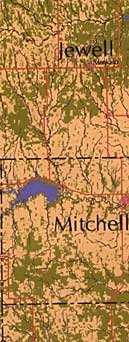
Segment of the Kansas Land Cover Patterns map.
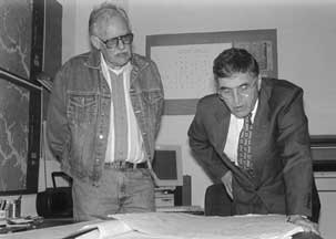
Geologist, astronaut, and former U.S. senator Harrison “Jack” Schmitt (right) talks with Kansas Geological Survey senior scientist Daniel Merriam. Schmitt was a member of the Apollo 17 crew that visited the moon in 1972. He came to the Survey and the University of Kansas in April to deliver a lecture on lunar geology to Survey staff and to the scientific society Sigma Xi.
Astronaut Delivers Lecture on Lunar Geology
URL:http://www.kgs.ku.edu/Publications/GeoRecord/1997/vol3.2/Page3.html