![]()
![]()
![]()
Prev--Post-meeting Field Trip 3
This trip focuses on late Quaternary alluvial stratigraphy and geoarcheology in the central Great Plains of Kansas and extreme northern Oklahoma. The first stop is at the Claussen archeological site on the bank of Mill Creek in northeastern Kansas. Mill Creek is a major tributary of the Kansas River and a good example of a Flint Hills stream. An extensive cutbank at the Claussen site provides an opportunity to examine the stratigraphic relationships of early, middle, and late Holocene alluvial fills. Archeological materials are contained in these fills, including Paleoarchaic cultural deposits at depths of 8-10 m below the land surface.
We will cross a steep bioclimatic gradient as we travel west from tallgrass prairie at the Claussen site to the shortgrass prairie of southwestern Kansas. At Stop 2, west of Garden City, Kansas, we will visit the Simshauser archeological site in Mattox Draw. Stratified cultural deposits at Simshauser, including an early Paleoindian component, are contained in an alluvial fan on the margin of the draw. We will examine the soil-stratigraphy of the fan and hear about the results of recent archeological testing at the site. We will also examine thick sections of late Wisconsinan and early Holocene valley fill beneath a broad terrace in Mattox Draw. Buried soils in the valley fill represent former landscapes that were probably occupied by Paleoindians and perhaps by pre-Clovis people.
The third stop is at the Winger archeological site in extreme southwestern Kansas. Winger is a deeply buried late Paleoindian bison bonebed exposed in the bank of Bear Creek, a tributary of the Arkansas River. The stratigraphic sequence at Winger includes early Holocene playa deposits, early Holocene alluvium, and late Holocene eolian sand. In addition to examining this stratigraphy, we will consider site-formation processes that resulted in excellent preservation of the bonebed.
The final three stops will be at the Waugh, Cooper, and Jake Bluff archeological sites in northwestern Oklahoma slightly south of the Kansas border. These three sites are near each other and are very significant archeological localities. The Waugh site includes a Folsom bison bonebed buried in alluvium at the head of Stockholm Canyon. The Cooper site also is a Folsom site and is a rare example of a stratified Paleo indian bison kill. At Cooper, an arroyo was used by Folsom hunters on three separate occasions to trap and kill bison. Jake Bluff, which is located adjacent to Cooper, represents a Clovis bison kill. Archeological excavations will be underway during our visit to Jake Bluff.
A road log is not included with this field trip. Unfortunately, Paleoindian sites are threatened by artifact collectors who often turn to the literature for site locations. The recent destruction of the Burntwood Creek site in northwestern Kansas is a case in point. Hence, we do not want to reveal the precise locations of the sites that will be visited during this trip.
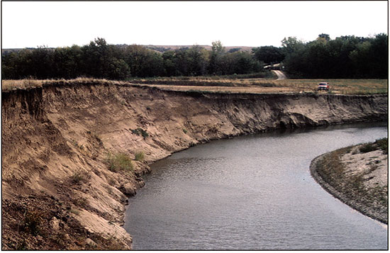
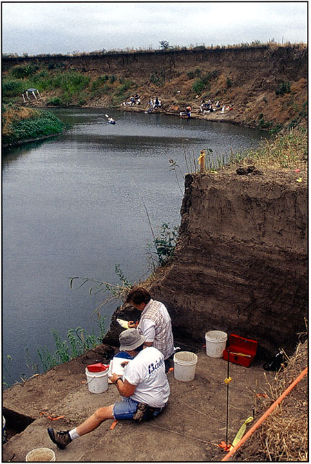
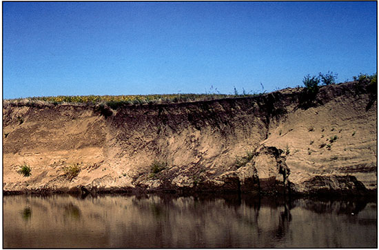
The Claussen site (14WB322) is located near the town of Paxico in the Flint Hills of northeastern Kansas (Stop 1 in fig. 4-1). This site has deeply buried archeological deposits preserved beneath the valley floor of lower Mill Creek, a large stream that joins the Kansas River approximately 20 km northeast of Paxico. The cultural deposits are exposed in a steep cutbank formed by lateral migration of the creek (fig. 4-2). Claussen was discovered by Rolfe Mandel in 1999, and subsequent archeological investigations identified multiple buried cultural deposits, including two Paleoarchaic components in the upper 40 cm of the A horizon of a buried soil approximately 10 m below the surface of the T-2 terrace of Mill Creek. Also, a cultural component of unknown age is about 10m below the T-2 surface. Charcoal from a hearth-like feature in the upper Paleoarchaic component yielded a 14C age of 8,800 ± 150 yrs B.P. (ISGS-4684). Charcoal from cultural features 25-35 cm below the upper component yielded AMS 14C ages of 9,225 ± 30 yrs B.P. (ISGS-AO479) and 9,225 ± 35 yrs B.P. (ISGS-AO480). Given the paucity of stratified, well-dated early Holocene sites in the Eastern Plains, Claussen is an important "window" into this period. Also, the depth of the buried cultural deposits at Claussen underscores the problem of finding early sites in alluvial settings on the Plains.
Figure 4-1--Map showing the stops for Trip 4. Stop 1: Claussen site; Stop 2: Simshauser site and Mattox Draw; Stop 3: Winger site; Stop 4: Waugh site; Stop 5: Cooper site; Stop 6: Jake Bluff site.
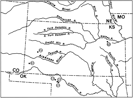
Figure 4-2--Photograph of the cutbank at the Claussen site. The vehicle is on the T-1 terrace, and the T-2 terrace is in the left foreground. The view is to the southeast. Mill Creek flows to the right in the photograph.
The Claussen site is in the Flint Hills region of the Central Lowlands Physiographic Province (Fenneman, 1931). This region trends north-south along the western edge of the Osage Cuestas and glaciated region of Kansas. The Flint Hills derived their name from the abundance of chert, or flint, scattered across the uplands. Like the Osage Cuestas to the east, the Flint Hills were formed by erosion of westward-dipping strata. The bedrock geology is characterized by interbedded limestones and shales deposited in shallow seas during the Permian Period about 280 million years ago. Differential erosion of these alternating beds of limestone and shale produce hillsides with stair-step topography. Some of the limestones contain layers or nodules of chert. Because chert is much less soluble than the limestone that encloses it, weathering of the softer rock forms a clay-rich soil containing many chert fragments (Wilson, 1984, p. 19). This gravel-rich soil armors the rocky uplands and reduces erosion rates compared to rates in adjacent areas where the limestone does not contain chert.
From an archeological perspective, the abundance of chert in the limestones is perhaps the most important characteristic of the Flint Hills environment. Due to its superior flaking qualities, Flint Hills chert provided excellent raw material for chipped stone tools and was heavily exploited by prehistoric inhabitants of the region.
The Flint Hills region is one of the largest expanses of tallgrass prairie remaining in North America (Chapman et al., 2001). The dominant grasses are big bluestem (Andropogon gerardi), little bluestem (Andropogon scoparius), Indian grass (Sorghastrum nutans), and switchgrass (Panicum virgatum). Trees are mostly restricted to valley floors, rugged ravines, and rocky hillsides. The riparian forests are dominated by cottonwood (Populus deltoides), hackberry (Celtis occidentalis), willow (Salix sp.), and elm (Ulmus sp.). Juniper (Juniperus sp.) and bur oak (Quercus macrocarpa) tend to occur in ravines and on rocky slopes that are insolated from fire, and black walnut (Juglans nigra), green ash (Fraxinus pennsylvanica), and sycamore (Platanus occidentalis) are common on mesic foot slopes and toe slopes.
At the Claussen site, the valley floor of Mill Creek is about 3 km wide and consists of a modern floodplain (T-0), a low alluvial terrace (T-1), and a high alluvial terrace (T-2). The T-0 surface is on the west side of the creek and is 1-2 m above mean low water level. As the lowest geomorphic surface in the valley, T-0 is frequently flooded, especially during the spring and early summer.
The T-1 surface is 2-3 m above the T-0 surface and is present on the east side of the creek at Claussen. Historic floods are known to overtop T-1, and the remnant of T-1 on the south side of the site is characterized by low-relief flood chutes oriented east-west. At Claussen, a prominent 5-m-high scarp separates the T-1 and T-2 surfaces (figs. 4-2 and 4-3).
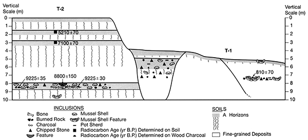
Figure 4-3--Diagram of the cutbank at the Claussen site showing the geomorphology, soil-stratigraphy, archeological components, and radiocarbon ages.
The T-2 terrace is the most extensive geomorphic surface within the valley of lower Mill Creek. At the Claussen site, T-2 spans more than three-quarters of the valley floor and is a flat and featureless surface. It gradually merges with colluvial aprons and alluvial fans at the foot of the valley wall north of I-70. However, in some reaches of lower Mill Creek, a 4-5-m-high scarp separates T-2 from narrow remnants of a Pleistocene terrace (T-3).
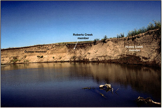
Three units of the DeForest formation are exposed in the cutbank at Claussen: the Gunder, Roberts Creek, and Honey Creek members (fig. 4-4). The DeForest formation is a lithostratigraphic unit containing fine-grained Holocene alluvium (Bettis, 1995). Although it was originally defined as a sequence of alluvial fills in small valleys of the Loess Hills in western Iowa (Daniels et al., 1963), the DeForest formation has been expanded into eastern Kansas (Mandel et al., 1991; Mandel, 1994; Mandel and Bettis, 2001, 2003).
Figure 4-4--Photograph of the cutbank at the Claussen site showing the stratigraphic relationships of the Gunder, Roberts Creek, and Honey Creek members of the DeForest formation. The view is to the east.
The Honey Creek member forms most of the valley fill beneath the T-1 terrace at Claussen. This unit consists of at least two laterally inset fills composed of stratified, dark-grayish-brown (10YR 4/2, moist) and dark-brown (10YR 3/3, moist) silt loam grading downward to grayish-brown (10YR 5/2, moist) and brown (10YR 4/3, moist) loam and fine sandy loam.
A buried Middle Ceramic component was observed in the Honey Creek member when the Claussen site was recorded by Mandel. This component is at a depth of 2.1-2.2 m below the T-1 surface and consists of mussel shells, chert flakes, fire-cracked rocks, pottery sherds, and burned-rock features. Charcoal from a burned-rock feature exposed in the cutbank yielded a radiocarbon age of 810 ± 70 yrs B.P. (ISGS-4831). In 2003, archeological investigations at Claussen included a 22-m2 excavation block that exposed the Middle Ceramic component in the T-1 fill (fig. 4-5).
Figure 4-5--Photograph of the 2003 excavation block exposing the Middle Ceramic component (floor of the excavation block) in the Honey Creek member at the Claussen site. The view is to the north.
Sediments comprising the Roberts Creek member fill a channel (flood chute?) at the foot of the scarp separating the T-1 and T-2 surfaces (figs. 4-4 and 4-6). A shallow buried soil with a thick, black (10YR 2/1, moist), cumulic A horizon is developed in the Roberts Creek member. Five separate cultural horizons were recorded in this buried soil during the 2003 excavations at Claussen. Although the numerical age of the cultural deposits is unknown, Early Ceramic pottery sherds (ca. 2,000-1,000 yrs B.P.) were recorded in the upper cultural horizon.
Figure 4-6--Photograph of the channel fill exposed in the cutbank at the Claussen site. Early Ceramic pottery sherds were recorded in the buried soil developed in the upper part of the channel fill. The view is to the east.
The Gunder member composes the valley fill beneath the T-2 terrace and mostly consists of moderately oxidized, fine-grained alluvium (fig. 4-7). In the section exposing T-2 fill at Claussen, the Gunder member is reduced below a depth of 9.7 m. The surface soil (Soil 1) developed at the top of the Gunder member has a thick, strongly expressed A-BA-Bw-Btk profile (fig. 4-8). This soil is welded to the A horizon of buried soil (Soil 2) at a depth of 1.52-1.87 cm below the T-2 surface. Soil 2 is 133 cm thick and has a strongly expressed A-Btk profile. Decalcified organic carbon from the upper 10 cm of Soil 2 yielded a radiocarbon age of 5,21 0 ± 70 yrs B.P. (ISGS-4511). Soil 2 is welded to the A horizon of a buried soil (Soil 3) at a depth of 2.85-3.25 m below the T-2 surface. Soil 3 is 310 cm thick and has a strongly expressed A-Btk-Bkss profile. Decalcified organic carbon from the upper 10 cm of Soil 3 yielded a radiocarbon age of7,100 ± 70 yrs B.P. (ISGS-4514). Laminated silty alluvium separates Soil 3 from the deepest buried soil (Soil 4) in the section. Soil 4 is 2 m thick and has a thick, cumulic A horizon above a Btk horizon. Radiocarbon ages determined on charcoal from cultural features indicate that the rate of sedimentation was very slow around 9,225 yrs B.P., and the early Holocene floodplain was stable by ca. 8,800 yrs B.P.
Figure 4-7--Photograph of the valley fill (Gunder member) beneath the T-2 terrace at the Claussen site. The person (just to the right of the center of the photograph) is pointing to Paleoarchaic cultural deposits at the top of the lowest buried soil in the section.
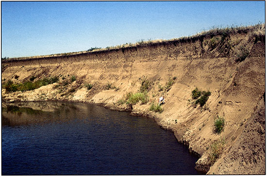
Figure 4-8--Radiocarbon ages of T-2 terrace at the Claussen site.
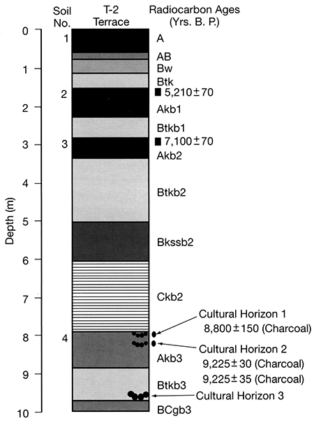
The soil-stratigraphic record and radiocarbon chronology indicate that Paleo archaic people repeatedly occupied the early Holocene (ca. 9,200-8,800 yrs B.P.) floodplain of Mill Creek at the Claussen site. Slow aggradation accompanied by pedogenesis formed a stratified record of human occupation within Soil 4. Rapid aggradation soon after ca. 8,800 yrs B.P., as indicated by a radiocarbon age at the Imthurn archeological site about 6 km downstream from Claussen, buried the early Holocene soil and sealed Paleoarchaic and potentially older cultural components beneath an 8-m-thick package of early through middle Holocene alluvium.
In 2003, 11.5 1 x 1-m archeological excavation units were placed along a 25-m-long exposure at the base of the cutbank exposing the T-2 valley fill at Claussen. The units were excavated in two areas: an upstream area designated as the west block, and an adjacent downstream area designated as the east block. The excavations yielded 261 bulk soil samples, each weighing approximately 50 pounds. These samples were water-screened on site.
A total station was used to map all cultural materials recorded in the west and east blocks. There are 185 mapped items from the Paleoarchaic component dating to ca. 9,250 yrs B.P., including chipped stone, bone, shell, and charcoal samples. Notable peaks in the vertical distribution of cultural materials and the absence of obvious sorting based on size, shape, or material suggest that the spatial integrity of this component is relatively intact.
No diagnostic artifacts were found within the 8,800-yr-old component or underlying cultural deposits during the 2003 field season. However, inspection of the site in 2005 resulted in the discovery of a Dalton projectile point in a small mass of soil that fell out of the Akb3 horizon and came to rest at the bottom of the section. Also, collectors have found Dalton and lanceolate projectile points on a gravel bar immediately downstream from the site.
Lithic materials identified to date are all derived from local or nearby sources of Permian-age Florence formation cherts. The occurrence of refits, the wide range in sizes and shapes of recovered pieces, and the lack of evidence for edge abrasion or stream rolling suggests that postdepositional alluvial transport has not been significant.
The few tools identified include two modified flakes and three flaked and battered cobbles (corelhammers). All are expedient tools that were made, used, and discarded at the site. One flake tool refits with one of the cobbles, which was apparently collected from the stream gravel in Mill Creek.
The high proportion offlakes that have platforms (75% platform-remnant-bearing based on piece plotted and 1/4-inch screen samples) indicates that post-manufacture breakage due to factors such as trampling has been minimal. This suggests an occupation or activity area usage of relatively short duration.
The rare occurrence of burned lithics (n = 5, 6% of piece plotted and 1/4-inch sample), which does not include the large corelhammers, suggests that burning of lithics was incidental and related to hearths rather than to general surface fires or natural burns. Also, the presence of latestage thinning and retouch flakes from bifaces indicates that tools were present that have not been recovered. In addition to flake tools, bifacial knives or projectile-point/knives were apparently used and resharpened, or possibly manufactured, at the site.
The archeofaunal assemblage dating to ca. 9,250 yrs B.P. included a variety of vertebrate (22 taxa) and invertebrate (three taxa) species. Medium ungulate taxa (Odocoileus or Odocoileus/Antilocapra) were the most common economic species. However, avian species, notably Meleagris gallopavo, also made up a significant portion of the archeofaunal assemblage. Bison (species indeterminate), Vulpes velox, lagomorph, and rodent taxa are all represented by single individuals and low NISPs. Preliminary identification of the mussel fauna indicates the presence of three species: Amblema plicata, Quadrula quadrula, and Fusconaia flava.
Burned bone specimens composed 23% of the mapped faunal sample and 37% of the bone recovered in the screens from 32R-25, the most productive excavation unit. Burning on both the interior and exterior of bone fragments suggests that most heat modification occurred after consumption.
Perhaps the most intriguing (and exciting) aspect of the archeological record at Claussen is the faunal assemblage. There is evidence that Early Archaic and Late Paleo indian occupants of the Western and Central Plains relied heavily on bison. The Winger site in southwestern Kansas, which will be visited during the field trip, is a case in point. However, at Claussen, faunal remains dating to ca. 8,800-9,300 yrs B.P. indicate that occupants of the site relied on a variety of animals for food. A large part of the assemblage is fragmented and burned, indicating a complex range of cultural and non cultural factors were involved in site-formation processes. Nevertheless, the faunal record at Claussen strongly suggests local subsistence behaviors at ca. 9,000 yrs B.P. that were very different from the bison-focused subsistence strategies of Native Americans on the Plains at that time. The diverse fauna and expedient technology at the site indicate an "Archaic" adaptation that may be more comparable to Dalton and later Eastern Woodland cultural complexes. Continued research at Claussen holds considerable potential to address the Paleoindian/Archaic interface.
The University of Kansas Odyssey Archeological Research Fund supported our investigations at the Claussen site.
Bettis, E. A., III, 1995, The Holocene stratigraphic record of entrenched stream systems in thick loess regions of the Mississippi River basin: Ph.D. dissertation, University of Iowa, 149 p.
Chapman, S. S., Omemick, J. M., Freeouf, J. A., Huggins, D. G., McCauley, J. R., Freeman, C. C., Steinauer, G., Angelo, R. T., and Schlepp, R. L., 2001, Ecoregions of Nebraska and Kansas (color poster with map, descriptive text, summary tables, and photographs): U.S. Geological Survey, map scale 1:1,950,000.
Daniels, R. B., Rubin, M., and Simpson, G. H., 1963, Alluvial chronology of the Thompson Creek watershed, Harrison County, Iowa: American Journal of Science, v. 261, p. 473-484.
Fenneman, N. E., 1931, Physiography of the western United States: New York, McGraw-Hill, 534 p.
Mandel, R. D., 1994, Geomorphology and stratigraphy of lower Mill Creek valley, Johnson County, Kansas; in, Archeological Test Excavations at Six Prehistoric Sites within the Lower Mill Creek Valley, Johnson County, Kansas, T. V. Gillen, R. P. Winham, E. J. Lueck, and L. A. Hanus, eds.: Sioux Falls, South Dakota, Augustana College, Archeology Laboratory, Archeology Contract Series no. 99, p.96-l25.
Mandel, R. D., and Bettis, E. A., III, 2001, Late Quaternary landscape evolution in the South Fork of the Big Nemaha River valley, southeastern Nebraska and northeastern Kansas: Guidebook No. II, Conservation and Survey Division, Institute of Agriculture and Natural Resources, University of Nebraska, Lincoln, Nebraska, 58 p.
Mandel, R. D., and Bettis, E. A., III, 2003, Late Quaternary landscape evolution and stratigraphy in northeastern Kansas and southeastern Nebraska; in, Geologic Field Trips in the Greater Kansas City Area (Western Missouri, Northeastern Kansas, and Southeastern Nebraska), T. N. Niemi, ed.: Guidebook for Field Trips, 37th North-central Section meeting of the Geological Society of America, Missouri Department of Natural Resources, Geological Survey and Resource Assessment Division, Special Publication No. 11, Rolla, Missouri, p. 127-176.
Mandel, R. D., Reynolds, J. D., Williams, B. G., and Wu1fkuhle, V. A., 1991, Upper Delaware River and tributaries watershed: Results of geomorphological and archeological studies in Atchison, Brown, Jackson, and Nemaha counties, Kansas: Topeka, Kansas State Historical Society, Contract Archeology Publication no. 9, 130 p.
Wilson, F., 1984, Landscapes: A geologic diary; in, Kansas Geology, R. Buchanan, ed.: Lawrence, University Press of Kansas, p. 9-39.
At Stop 2 in southwestern Kansas (fig. 4-1), we will visit the Simshauser site (14KY102) and adjacent exposures of late Wisconsinan and early Holocene valley fill in Mattox Draw. Simshauser is a stratified site with at least one Paleoindian component. The site is associated with a small alluvial fan on the margin of the valley floor of Mattox Draw. The channel of Mattox Draw migrated laterally and cut into the fan, opening a "window" into this landform sediment assemblage. We will examine a 4-m-high section of early Holocene fan deposits and discuss the soil stratigraphy and associated cultural deposits.
Following our visit to the Simshauser site, we will walk north several hundred meters and examine late Wisconsinan and early Holocene valley fill exposed in a long, high cutbank along a meander loop of Mattox Draw. The cutbank reveals a complex soil-stratigraphic record and sheds light on why Paleoindian sites are so elusive on the High Plains.
Stop 2 is located in the semiarid High Plains region of Fenneman's (1931) Great Plains physiographic province. The broad, flat uplands are mantled by 2-3 m of late Wisconsinan-age Peoria Loess. In many areas, a unit of Pleistocene alluvium separates the loess from late Tertiary alluvium of the Ogallala Formation.
Mattox Draw, which drains to the Arkansas River, is deeply entrenched in the Ogallala Formation (fig. 4-9). Like the other dry valleys, or draws, in the region, Mattox is an intermittent stream; it only carries water immediately after heavy rainfalls. Quaternary alluvium is stored beneath two geomorphic surfaces in the draw: a low, narrow floodplain (T-0) and a high, broad terrace (T-1) (fig. 4-9). Small alluvial fans, such as the one at the Simshauser site, are common along the margins of the draw and often merge with valley fill beneath the T-1 terrace.
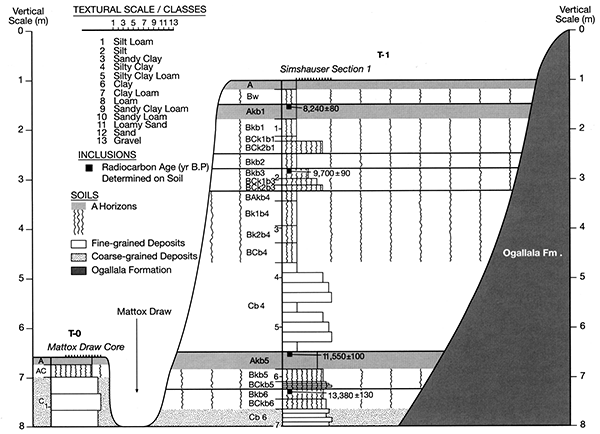
Figure 4-9--Cross section of Mattox Draw showing the landform sediment assemblages, soil stratigraphy, sedimentology, and radiocarbon ages.
The Simshauser alluvial fan formed at the mouth of a small, first-order drainage element extending into the adjacent loess-mantled uplands (fig. 4-10). Although the distal end of the fan has been removed by stream erosion, the geometry of the fan is still quite apparent. There are distinct lobes of sediment on both sides of the fan-head trench, and the modern surface of the lobes dips away from the trench. The cutbank at Simshauser provides an excellent opportunity to view the buried paleo-landscape within and adjacent to the fan. The geometry of buried fan surfaces, marked by paleosols, resembles the modern geometry of the fan, i.e., the buried soils dip away from the fan head trench (figs. 4-11 and 4-12).
Figure 4-10--Photograph of the Simshauser fan (site 14KY102). The view is to the north.
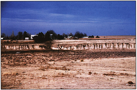
Figure 4-11--Diagram of the cutbank at the Simshauser site showing the soil stratigraphy, sedimentology, archeological components, and radiocarbon ages.
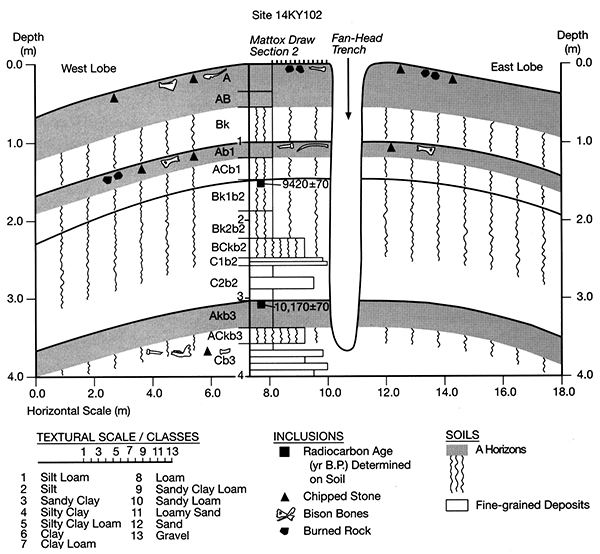
Figure 4-12--Photograph of the west lobe of the Simshauser fan (site 14KYI02). The view is to the north. Note the buried soil dipping to the west.
The alluvium composing the Simshauser fan is predominantly silt loam derived from the loess on the adjacent uplands. However, coarser sediment, including sand and gravel, occurs in the lower 1.5 m of the fan (fig. 4-11). Three buried soils are found in the upper 4 m of the fan (fig. 4-11). The upper buried soil (100-148 cm below surface) has a weakly expressed A-AC profile (fig. 4-11 and table 4-1). The middle buried soil (148-188 cm below surface) is developed at the top of an upward-fining sequence and has a well-expressed Bk-BCk profile (fig. 4-11 and table 4-1); the A horizon was stripped off by erosion before the soil was buried. The lower buried soil (303-358 cm below surface) also is developed at the top of an upward-fining sequence but has a thick, cumulic Ak horizon above an ACk horizon (fig. 4-11 and table 4-1). Decalcified soil carbon from the upper 10 cm of the Akb3 and Bk1b2 horizons yielded radiocarbon ages of 10,170 ± 70 yrs B.P. (ISGS-4675) and 9,420 ± 70 yrs B.p. (ISGS-4676), respectively (fig. 4-11).
The initial investigation at Simshauser focused on the cutbank exposing alluvium beneath the west lobe of the fan. Cultural deposits, including flakes, burned rock, and bison bones, were recorded in the upper 15 cm of the A horizon of the surface soil and in the A horizon of the upper buried soil (fig. 4-11). Presently, only one thing that can be said about the ages of these archeological components: they are younger than ca. 9,400 yrs B.P.
In addition to the upper two archeological components, bison bones and a single chert flake were found in the ACkb3 horizon of the lower buried soil (fig. 4-11 and 4-13). Based on the radiocarbon age determined on decalcified soil carbon from the overlying Akb3 horizon, the lowest archeological component in the section is older than ca. 10,100 yrs B.P. Hence, unless the radiocarbon age is problematic, this component represents a Paleoindian camp and/or bison kill site. Archeological testing of the Simshauser site will be conducted by the University of Kansas, June 15-25, 2004, with most of the effort focusing on the lowest cultural component. Results of the testing will be presented during our visit to the site.
Figure 4-13--Photograph of the thick, buried soil and underlying bison bone in the west lobe of the Simshauser fan (site 14KY102).
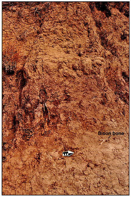
Table 4-1--Description of the section exposed beneath the west lobe at the Simshauser site.
| Depth (cm) |
Soil Horizon |
Description |
|---|---|---|
| 0-5 | A1 | Brown (10YR 5/3) silt loam, dark-brown (10YR 4/3) moist; weak medium and fine platy structure parting to weak fine granular; friable; many fine and very fine roots; abrupt smooth boundary. |
| 5-35 | A2 | Brown (10YR 5/3) silt loam, dark-brown (10YR 4/3) moist; weak fine subangular blocky structure parting to weak fine and medium granular; friable; many fine and very fine roots; many worm casts; gradual smooth boundary. |
| 35-55 | AB | Brown (10YR 5/3) silt loam, dark-brown (10YR 4/3) moist; weak fine subangular blocky structure parting to weak fine and medium granular; friable; many fine and very fine roots; common worm casts; gradual smooth boundary. |
| 55-100 | Bk | Yellowish-brown (10YR 5/4) silt loam, dark-yellowish-brown (10YR 4/4) moist; weak fine and medium prismatic structure parting to moderate fine subangular blocky; friable; common films and threads of calcium carbonate; many fine and very fine roots; common worm casts and open worm burrows; abrupt smooth boundary. |
| 100-120 | Akb1 | Brown (10YR 5/3) light silty clay loam, dark-brown (10YR 4/3) moist; weak medium prismatic structure parting to moderate coarse granular and very fine subangular blocky; friable; common grayish-brown (10YR 5/2) organic coatings on ped faces; many films and threads of calcium carbonate; many fine and very fine roots; common worm casts and open worm burrows; gradual smooth boundary. |
| 120-148 | ACkb1 | Brown (10YR 5/3) light silty clay loam, dark-brown (10YR 4/3) moist; weak medium and coarse prismatic structure parting to medium and fine angular blocky; hard; faint bedding; peds part along bedding planes; common grayish-brown (10YR 5/2) organic coatings on ped faces; few laminae of pale-brown (10YR 6/3) silt loam and yellowish-brown (10YR 5/4) loam; many films and threads of calcium carbonate; common fine and very fine roots; few worm casts and open worm burrows; abrupt smooth boundary. |
| 148-188 | Bkab2 | Yellowish-brown (10YR 5/4) to brown (10YR 5/3) silt loam, dark-yellowish-brown (10YR 4/4) to dark-brown (10YR 4/3) moist; weak fine prismatic structure parting to weak fine subangular blocky; hard; many films and threads of calcium carbonate; few fine and very fine roots; gradual smooth boundary. |
| 188-223 | Bk2b2 | Yellowish-brown (10YR 5/4) silt loam, dark-yellowish-brown (10YR 4/4) to dark-brown (10YR 4/3) moist; weak fine prismatic structure parting to weak fine subangular blocky; hard; many very fine and fine threads of calcium carbonate; few fine and very fine roots; gradual smooth boundary. |
| 223-248 | BCkb2 | Yellowish-brown (10YR 5/4) silt loam, dark-yellowish-brown (10YR 4/4) to dark-brown (10YR 4/3) moist; very weak fine prismatic structure parting to very weak fine subangular blocky; hard; faint bedding; common fine threads of calcium carbonate; gradual smooth boundary. |
| 248-257 | C1b2 | Stratified yellowish-brown (10YR 5/4) sand interbedded with fine gravel; single grain; loose; abrupt smooth boundary. |
| 257-303 | C2b2 | Stratified brown (10YR 5/3) and pale-brown (10YR 6/3) silt loam interbedded with very fine sandy loam; few lenses of sand and granules; massive; friable; abrupt smooth boundary. |
| 303-338 | Akb3 | Dark-grayish-brown (10YR 4/2) silt loam, very dark grayish-brown (10YR 3/2) moist; weak fine prismatic structure parting to moderate medium and coarse granular; friable; common fine and very fine threads of calcium carbonate; gradual smooth boundary. |
| 338-358 | ACkb3 | Dark-brown (10YR 4/3-3/3) loam, very dark grayish-brown (10YR 3/2) moist; weak fine granular structure; friable; faint bedding; common fine and very fine threads of calcium carbonate; common lenses of granules and pebbles; gradual smooth boundary. |
| 358-400 | Cb3 | Stratified brown (10YR 5/3) silt loam, pale-brown (10YR 6/3) loam, and pale-brown (10YR 6/3) and yellowish-brown (10YR 5/4) fine sandy loam interbedded with sand and fine gravel; massive; hard. |
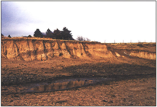
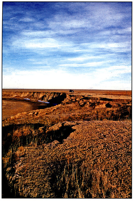
During our first visit to the Simshauser site in 1998, we also inspected the impressive cutbank spanning the meander loop of Mattox Draw immediately south of the site (fig. 4-14). None of the fills in the draws of western Kansas had been dated prior to our visit. Hence, we could only speculate on the age of the deposits exposed in the cutbank. Previous geomorphological investigations that focused on small streams in western Kansas determined that only late Holocene valley fill is stored in their valleys (see Mandel, 1994, 1995). Therefore, we thought this might also apply to Mattox Draw, even though it is an intermittent drainage element high in the drainage network. Our speculation, however, was proven wrong.
Figure 4-14--Photograph of the cutbank that spans the meander loop of Mattox Draw. The view is to the north.
A section of valley fill beneath the T-1 terrace of Mattox Draw was cleaned with hand shovels and described (fig. 4-9 and table 4-2). There are six buried soils in the 7-m-high section. The surface soil and first four buried soils at the top of the section form a pedo-complex spanning the upper 3.7 m of the T-1 fill (fig. 4-9 and table 4-2). We refer to it as a pedocomplex because the bottom of each soil is welded to the top of the soil beneath it. All of these soils have Bk horizons, but the carbonate morphology is weak (stage I-I+ as defined by Birkeland [1999, table A1.5]). Decalcified soil carbon from the upper 10 cm of the Akb1 and Bkb3 horizons yielded radiocarbon ages of 8,240 ± 80 yrs B.P (ISGS-4645) and 9,700 ± 90 yrs B.P. (ISGS-4643), respectively. A 1.8-m-thick zone of laminated silt loam interbedded with very fine sandy loam, fine sand, and pebbles (Cb4 horizon in fig. 4-9 and table 4-2) separates the pedocomplex from a pair of buried soils near the bottom of the section (fig. 4-9). The next to the lowest buried soil has a well-expressed A-Bk-BCk profile, and the lowest buried soil is represented by a truncated Bk horizon. Decalcified soil carbon from the upper 10 cm of the Akb5 and Bkb6 horizons yielded radiocarbon ages of 11,550 ± 100 yrs B.P (ISGS-4673) and 13,380 ± 130 yrs B.P. (ISGS-4672), respectively.
Table 4-2--Description of the section exposed beneath T-1 terrace of Mattox Draw.
| Depth (cm) |
Soil Horizon |
Description |
|---|---|---|
| 0-20 | A Brown | (10YR 5/3) to dark-brown (10YR 4/3) silt loam, dark-brown (10YR 4/3) moist; weak fine subangular blocky structure parting to weak fine and medium granular; friable; many fine and very fine roots; gradual smooth boundary. |
| 20-50 | Bw Brown | (10YR 5/3) silt loam, dark-brown (10YR 4/3) moist; weak fine prismatic structure parting to weak fine subangular blocky; friable; common fine and very fine roots; clear smooth boundary. |
| 50-80 | Akb1 | Dark-brown (10YR 4/3) silt loam, dark-brown (10YR 3/3) moist; weak fine prismatic structure parting to moderate medium and coarse granular; friable; common films and few threads of calcium carbonate; common fine and very fine roots; gradual smooth boundary. |
| 80-115 | Bkb1 | Brown (10YR 5/3) silt loam, dark-brown (10YR 4/3) moist; weak fine and medium prismatic structure parting to weak fine and very fine subangular blocky; friable; few fine threads of calcium carbonate; few fine and very fine roots; gradual smooth boundary. |
| 115-150 | BCkb1 | Brown (10YR 5/3) to yellowish-brown (10YR 5/4) loam grading downward to fine sandy loam, dark-brown (10YR 4/3) to dark-yellowish-brown (10YR 4/4) moist; weak coarse prismatic structure parting to very weak fine and very fine subangular blocky; friable; few fine threads of calcium carbonate; few fine and very fine roots; abrupt smooth boundary. |
| 150-180 | Bkb2 | Brown (10YR 5/3) to yellowish-brown (10YR 5/4) silt loam, dark-brown (10YR 4/3) to dark-yellowish-brown (10YR 4/4) moist; weak medium prismatic structure parting to moderate medium and fine subangular blocky; friable; common films and threads of calcium carbonate; few fine and very fine roots; abrupt smooth boundary. |
| 180-200 | Bkb3 | Brown (10YR 5/3) light silty clay loam, dark-brown (10YR 4/3) moist; moderate medium prismatic structure parting to moderate fine and medium subangular blocky; hard; many nearly continuous films of calcium carbonate on ped faces; common fine threads of calcium carbonate; few very fine roots; gradual smooth boundary. |
| 200-225 | BCkb3 | Brown (10YR 5/3) to yellowish-brown (10YR 5/4) loam grading downward to very fine sandy loam, dark-brown (10YR 4/3) to dark-yellowish-brown (10YR 4/4) moist; weak coarse prismatic structure parting to very weak fine and very fine subangular blocky; friable; very faint bedding; common films and very fine threads of calcium carbonate; few very fine roots; abrupt smooth boundary. |
| 225-245 | BAkb4 | Brown (10YR 5/3) silt loam, dark-brown (10YR 4/3) moist; weak fine prismatic structure parting to weak fine and to very fine subangular blocky; friable; many fine and very fine dark-gray ish-brown (10YR 4/2) organic coatings on ped surfaces; many threads and common films of calcium carbonate; few very fine roots; gradual smooth boundary. |
| 245-295 | Bk1b4 | Brown (10YR 5/3) to yellowish-brown (10YR 5/4) silt loam, dark-brown (10YR 4/3) to dark-yellowish-brown (10YR 4/4) moist; weak medium and fine prismatic structure parting to weak fine subangular blocky; friable; common very fine threads and few films of calcium carbonate; few very fine roots; gradual smooth boundary. |
| 295-330 | Bk2b4 | Pale-brown (10YR 6/3) to light-yellowish-brown (10YR 6/4) silt loam, brown (10YR 5/3) to yellowish-brown (10YR 5/4) moist; weak medium and fine prismatic structure parting to weak fine subangular blocky; friable; common very fine threads and few films of calcium carbonate; few very fine roots; gradual smooth boundary. |
| 330-370 | BCb4 | Pale-brown (10YR 6/3) to light-yellowish-brown (10YR 6/4) silt loam, brown (10YR 5/3) to yellowish-brown (10YR 5/4) moist; weak coarse prismatic structure parting to very weak fine subangular blocky; friable; faint bedding; few very fine roots; gradual smooth boundary. |
| 370-550 | Cb4 | Laminated pale-brown (10YR 6/3) silt loam interbedded with very fine sandy loam, brown (10YR 5/3) moist; massive; soft, very friable; common lenses of fine sand and small pebbles at 440-445 em; abrupt wavy boundary. |
| 550-585 | Akb5 | Dark-brown (10YR 4/3) loam, dark-brown (10YR 3/3) moist; very weak medium prismatic structure parting to weak fine granular; friable; common coarse threads and few films of calcium carbonate; few siliceous granules; gradual smooth boundary. |
| 585-610 | Bkb5 | Brown (10YR 5/3) fine sandy loam, dark-brown (10YR 4/3) moist; weak fine and medium prismatic structure parting to weak fine subangular blocky; friable; common coarse threads and few films of calcium carbonate; few siliceous pebbles and granules; gradual smooth boundary. |
| 610-625 | BCkb5 | Brown (10YR 5/3) to yellowish-brown (10YR 5/4) loamy fine sand, yellowish-brown (10YR 5/4) moist; very weak coarse prismatic structure parting to very weak fine subangular blocky; friable; common coarse threads and few films of calcium carbonate; common lenses of siliceous granules and fine pebbles; abrupt smooth boundary. |
| 625-645 | Bkb6 | Brown (10YR 5/3) fine sandy loam, dark-brown (10YR 4/3) moist; weak medium prismatic structure parting to weak fine subangular blocky; friable; common fine threads and few fine films of calcium carbonate; common lenses of siliceous granules and fine pebbles; gradual smooth boundary. |
| 645-665 | BCkb6 | Pale-brown (10YR 6/3) loamy fine sand, brown (10YR 5/3) moist; very weak coarse prismatic structure parting to very weak fine subangular blocky; friable; common fine threads and few films of calcium carbonate; common lenses of siliceous granules and fine pebbles; gradual smooth boundary. |
| 665-700+ | Cb6 | Pale-brown (10YR 6/3) very fine and fine sand interbedded with loamy fine sand, brown (10YR 5/3) moist; massive; friable; common lenses of siliceous granules and fine pebbles. |
Based on the suite of radiocarbon ages for the T-1 terrace fill, there is a tremendous volume of late Wisconsinan through early Holocene alluvium stored in Mattox Draw. There is no evidence of middle Holocene alluvium in the draw, and late Holocene alluvium that appears to be less than 1,000 years old is restricted to the modern floodplain (T-0). This pattern of late Wisconsinan through early Holocene sediment storage has been documented in draws throughout western Kansas (Mandel, 2001). Since ca. 8,000 yrs B.P., headward erosion in the draws has not been sufficient to remove the late Wisconsinan and early Holocene alluvium. Bettis (1990) noted a similar pattern of sediment storage high in drainage networks in the Loess Hills of western Iowa.
From an archeological perspective, the presence of multiple buried soils dating between ca. 13,300 and 8,200 yrs B.P. is very significant. These soils represent landscapes that may have been occupied by humans during and immediately after the Pleistocene-Holocene transition. It is important to note that the Clovis-age landscape is about 5.5 m below the T-1 surface. This underscores the problem of finding Paleo indian archeological deposits in a stratified context in the region. Artifact collectors have discovered Early through Late Paleo indian artifacts in the dry channel of Mattox Draw, and we now know the likely source of these materials: the T-1 fill. The task is to find "windows" into the T-1 fill and thereby systematically search for in situ Paleo indian and pre-Clovis cultural deposits. Such an effort is currently underway through the University of Kansas Odyssey Archeological Research Program.
Bettis, E. A., III, 1990. Holocene alluvial stratigraphy and selected aspects of the Quaternary history of western Iowa: University of Iowa, Iowa Quaternary Studies Group Contribution 36, 328 p.
Birkeland, P. W., 1999, Soils and geomorphology (3rd ed.): Oxford, Oxford University Press, 430 p.
Fenneman, N. E., 1931, Physiography of the western United States: New York, McGraw-Hill, 534 p.
Mandel, R. D., 1994, Holocene landscape evolution in the Pawnee River basin, southwestern Kansas: Kansas Geological Survey and the Kansas State Historical Society, Bulletin 236, 117 p.
Mandel, R. D., 1995, Geomorphic controls of the Archaic record in the Central Plains of the United States; in, Archaeological Geology of the Archaic Period in North America, E. A. Bettis, III, ed.: Geological Society of America Special Paper 297, p. 37-66.
Mandel, R. D., 2001, The effects of Holocene climatic change on river systems in the Central Great Plains of North America: University of Nebraska, Program and Abstracts of the 7th International Conference on Fluvial Sedimentology, p. 191.
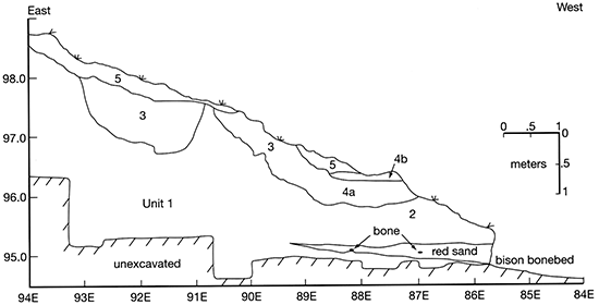
The Winger site (14ST40 I), located in Stanton County in southwestern Kansas (see Stop 3 in fig. 4-1), is a deeply buried Late Paleoindian bison bone bed. The bonebed is exposed in the bank of Bear Creek, a tributary of the Arkansas River. At Winger, Bear Creek has cut into the edge of one of the many playa basins that dot the landscape.
In 1966, the Winger site was visited by the late Virginia Buckner, an avocational archeologist who lived in southwestern Kansas. Buckner and several of her associates periodically conducted investigations at the site from 1970 to 1972. During that period, at least 45 linear meters of the bonebed were visible at a depth of 2.5-3.0 m below the surface (Buckner, 1970). They excavated two trenches and four contiguous 5 x 5-ft squares down to the bonebed, leaving the bones in place and covering the exposed bone with plastic before closing the excavation in 1972. From the first trench, Buckner reported remains of at least seven bison, using rib cages and vertebral columns for this estimate. She also noted articulated limbs, phalanges, and tooth rows. Although two "flakes of flint" were found at the bone level in the eastern trench (Buckner, 1973), no diagnostic artifacts were recovered during Buckner's excavations. Buckner (1970) reported that the late Dr. Waldo Wedel, senior archeologist with the Smithsonian Institution, visited the Winger site in August 1970, and conducted "a small exploratory excavation." However, Wedel did not conduct further research at the site, and Winger was abandoned by Buckner in 1972.
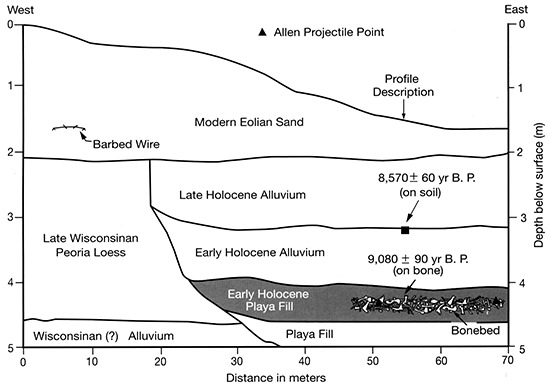
The Winger site was relocated in June of 2001 as part of Mandel's statewide geoarcheological research project in Kansas. During our initial visit to the site, we discovered that recent construction of a ranch road leading to the dry bed of Bear Creek exposed part of the bonebed in the area of Buckner's excavation. Also, hundreds of bone fragments were scattered across the streambed because of road construction and sand quarrying. A dense, 35-m-long bison bonebed averaging about 25 cm thick was recorded at a depth of 265-290 cm in the cutbank. At that time, a portion of the cutbank was cleaned from top to bottom just west of what we believe was Buckner's excavation, and a 1.5-m-wide profile was described (Mandel and Hofman, 2003). In addition, bones from the floor of the channel and from a small portion of the bonebed were collected. The collagen fraction from a sample of cleaned rib blade fragments collected from the bonebed yielded a δ13C corrected 14C age of 9,080 ± 90 yrs B.P. (ISGS-4934) (Mandel and Hofman, 2003). Given this radiocarbon age, we suspected that the bonebed represented a Paleoindian kill site. Hence, the significance of the Winger site for addressing problems of early Holocene paleoecology and archeology was apparent.
Following preliminary work in May 2002, the combined University of Kansas and University of Missouri archeological field school spent most of June 2002 excavating Winger. Approximately 9 m2 of the bonebed were excavated. Also, most of the disturbed bonebed sediment was wet screened. Soil and stratigraphic investigations accompanied the archeological studies.
The Winger site is located in the semiarid High Plains region of Fenneman's (1931) Great Plains physiographic province. Surficial deposits of the region consist oflate Pleistocene loess (Frye and Leonard, 1951, 1952). The loess mantles Pleistocene alluvium, which in turn overlies late Tertiary alluvium of the Ogallala Formation.
The High Plains surface is relatively flat and featureless. However, there are thousands of shallow depressions, or playas, scattered across the broad interfluves (Frye, 1950; Mandel, 2000). The playas range from a few meters to several kilometers in diameter, and while most are less than 3 m deep, some of the larger ones are 15-20 m deep.
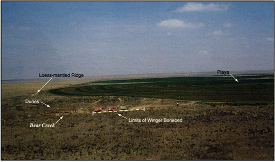
Winger is at the thalweg of a meander reach of Bear Creek, an intermittent stream, or draw, that rarely carries water. Because of lateral migration, the channel of Bear Creek has cut into the southern margin of a modern playa basin (fig. 4-15). This basin is elliptical and has an area of about 1.5 km2. The present basin floor is about 5 m below the surrounding surface. There is a loess-mantled rim around the playa basin, except where Bear Creek removed the south rim.
Figure 4-15--Aerial photograph showing the location of the Winger bonebed in relation to Bear Creek and the sand dunes, loessmantled ridge, and playa. The view is to the north.
The Winger bonebed is contained in playa fill at the base of the north bank of Bear Creek (figs. 4-16 through 4-19). The stratigraphic relationship of this playa fill to the modern playa basin on the northern fringe of the site is unknown.
Figure 4-16--Photograph of the Winger site. The people are in the dry channel of Bear Creek, and the arrow points to the location of the bonebed in the cutbank. The view is to the west.
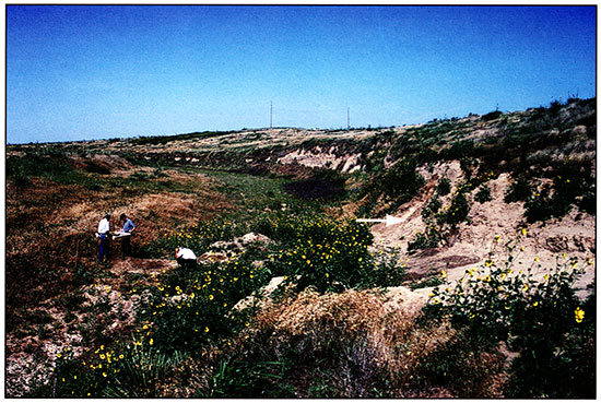
Figure 4-17--Photograph of the cutbank at the Winger site prior to excavation. The view is to the west-northwest.
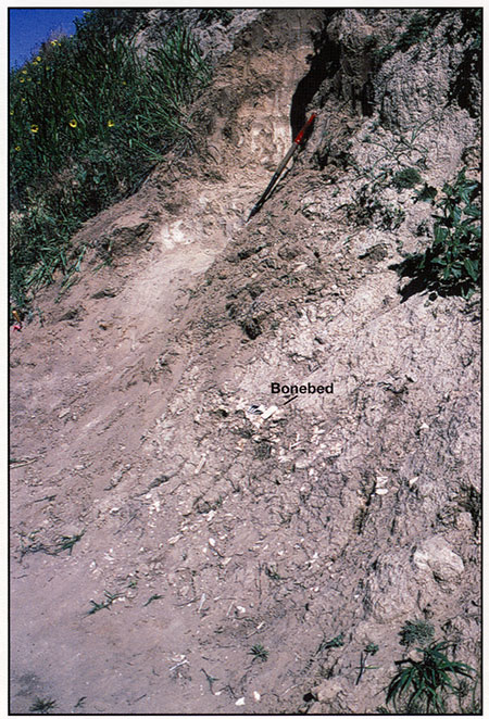
Figure 4-18--Photograph of the section that was described at the Winger site. The stratigraphy is illustrated in fig. 4-20. The photo-scale at the bottom of section is resting on the bonebed. The view is to the north.
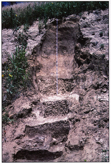
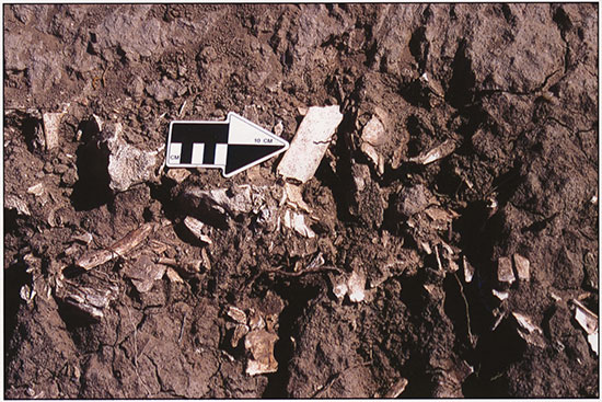
Figure 4-19--Photograph of the bonebed at the Winger site. The photo-scale is 20 cm long.
The playa fill at Winger is cut into late Wisconsinan Peoria Loess and underlying alluvium (fig. 4-20). The fill is clayey, very dark grayish-brown to olive-brown (moist colors), and noncalcareous. Similar pond deposits have been identified in playas in western Kansas (Mandel, 2000). The Winger bonebed is 13 cm below the top of the playa fill (figs. 4-18 and 4-19).
Figure 4-20--Stratigraphy exposed along the length of the cutbank at the Winger site.
Two soils are developed in the exposed portion of the playa fill. Only the upper 33 cm of the lower playa soil is exposed in the cutbank at Winger. This portion of the soil has ABk-Bk horizonation (fig. 4-21 and table 4-3) and redoximorphic features (i.e., yellowish-red mottles). The texture is silty clay and the carbonate morphology is relatively weak (stage I+ as defined by Birkeland [1999, table A1.5]).
Figure 4-21--Soil-stratigraphic profile described at the Winger site. This section is shown in fig. 4-18.
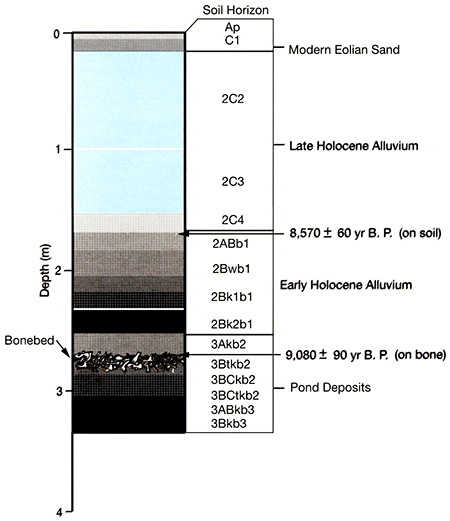
The upper playa soil has an Ak-Btk-BCk profile and is silty clay loam from top to bottom (fig. 4-21 and table 4-3). Moist colors range from very dark grayish-brown (10YR 3/2) in the 3Akb2 horizon to dark-brown (10YR 3/3) in the 3BCtkb2 horizon, and there are few yellowish-brown (10YR 5/4 and 5/6) mottles in the 3Akb2 horizon. Carbonate morphology is weak (stage I as defined by Birkeland [1999, table A1.5]) compared to the underlying playa soil, but there is evidence of clay illuviation in the form of discontinuous clay films on ped faces and the walls of pores in the 3Btkb2 and 3BCtkb2 horizons. Laminae composed of very pale brown (10YR 7/3) and very light grayish-brown (10YR 7/2) silt loam are common in the 3BCtkb2 horizon. They are laterally discontinuous and probably represent slopewash derived from the adjacent Peoria Loess, although an eolian origin cannot be ruled out. The bonebed is almost entirely within the 3Btkb2 horizon. However, there is some bone in the lower 2 cm and upper 3 cm of the 3Akb2 and 3Btkb2 horizons, respectively.
The presence of the bonebed within the 3Btkb2 horizon indicates that the playa fill was aggrading at the time of the bison kill; it was not a completely stable soil-forming environment. The bone bed was quickly buried in pond deposits, and there was an episode of landscape stability and concomitant soil formation in the playa soon after the bonebed formed (ca. 9,000 yrs B.P.). However, as explained in the following discussion, the episode of pedogenesis that produced the upper playa soil was brief.
The pond deposits are mantled by an 87-cm-thick unit of brown to yellowish-brown silty alluvium (fig. 4-20). A soil with an AB-Bw-Bk profile developed in the alluvium (fig. 4-21 and table 4-3). Decalcified bulk organic carbon from the upper 10 cm of the 2ABb1 horizon yielded a δ13C corrected 14C age of 8,570 ± 60 yrs B.P. (ISGS-5192). This age, combined with the age determined on bone from the underlying bonebed (ca. 9,000 yrs B.P. [Mandel and Hofman, 2003]), suggests that approximately 500 years elapsed between the time of the kill and end of soil development in the unit of silty alluvium. Other events during these 500 years include the accumulation of 13 cm of pond sediment above the bonebed, development of a soil at the top of the pond deposits, and accumulation of nearly 1 m of silty alluvium above the pond deposits. Hence, it is reasonable to assume that the bonebed was only on the land surface for a short time, and that it was not affected by a long episode of pedogeneis after it was buried. Instead, it was sealed beneath the pond sediments and overlying alluvium soon after ca. 9,000 yrs B.P. This is consistent with the excellent condition of the bone surfaces and preservation of articulated skeletons.
Table 4-3--Description of the soil stratigraphy at the Winger site.
| Depth (cm) |
Soil Horizon |
Description |
|---|---|---|
| EOLIAN SAND | ||
| 0-15 | Ap | Pale-brown (10YR 6/3) fine sandy loam, brown (10YR 5/3) moist; very weak fine granular structure; very friable; abrupt smooth boundary. |
| 15-35 | C1 | Pale-brown (10YR 6/3) fine sandy loam, brown (10YR 5/3) moist; single grain; loose; horizontal bedding; abrupt smooth boundary. |
| ALLUVIUM | ||
| 35-98 | 2C2 | Stratified light-grayish-brown (10YR 6/2) silt loam, grayish-brown (10YR 5/2) moist; interbedded with brown (10YR 5/3) fine sandy loam, loamy fine sand, and very fine sand, brown (10YR 4/3) moist; massive; very friable; horizontal bedding; few krotovina 6-8 cm in diameter filled with pale-brown (10YR 6/3) fine sandy loam; abrupt wavy boundary. |
| 98-150 | 2C3 | Stratified light-yellowish-brown (10YR 6/4) loamy fine sand and very fine sand, yellowish-brown (10YR 5/4) moist; massive parting to single grain; few krotovina 6-8 cm in diameter filled with light-grayish-brown (10YR 612) silt loam; abrupt wavy boundary. |
| 150-165 | 2C4 | Stratified light-grayish-brown (10YR 6/2) silt loam, grayish-brown (10YR 5/2) moist; interbedded with laminae of brown (10YR 4/3) silty clay loam, dark-brown (10YR 3/3) moist; massive; very friable; common lenses of sand, granules, and fine pebbles; horizontal bedding; abrupt wavy boundary. |
| 165-185 | 2ABb1 | Brown (10YR 5/3) to yellowish-brown (10YR 5/4) silt loam, brown (10YR 4/3) to dark-yellowish-brown (10YR 4/4) moist; few fine distinct yellowish-brown (10YR 5/6) mottles; weak fine prismatic structure parting to moderate fine and medium granular; friable; very few fine threads of calcium carbonate; common fine and very fine pores; many worm casts and open worm burrows; gradual smooth boundary. |
| 185-211 | 2Bwb1 | Brown (10YR 5/3) to yellowish-brown (10YR 5/4) silt loam, brown (10YR 4/3) to dark-yellowish-brown (10YR 4/4) moist; few fine distinct yellowish-brown (10YR 5/6) mottles; weak fine prismatic structure parting to weak fine and very fine subangular blocky; hard; friable; common fine and medium pores; common worm casts and open worm burrows; gradual smooth boundary. |
| 211-237 | 2Bk1b1 | Pale-brown (10YR 6/3) silt loam, brown (10YR 5/3) to yellowish-brown (10YR 5/4) moist; weak fine prismatic structure parting to weak fine and very fine subangular blocky; hard; friable; common fine threads of calcium carbonate; common fine and medium pores; few worm casts and open worm burrows; gradual smooth boundary. |
| 237-252 | 2Bk2b1 | Brown (10YR 5/3) silt loam, brown (10YR 4/3) to dark-brown (10YR 3/3) moist; weak fine prismatic structure parting to weak fine and very fine subangular blocky; hard, friable; common fine threads of calcium carbonate; common fine and medium pores; abrupt smooth boundary. |
| POND DEPOSITS | ||
| 252-267 | 3Akb2 | Dark-grayish-brown (10YR 4/2) silty clay loam, very dark grayish-brown (10YR 3/2) moist; common fine faint-yellowish-brown (10YR 5/4) and few fine distinct yellowish-brown (10YR 5/6) mottles; weak fine subangular blocky structure parting to moderate medium and coarse granular; hard, friable; common very fine and fine threads of calcium carbonate; many bison bones and bone fragments in lower 2 cm of horizon; gradual smooth boundary. |
| 267-287 | 3Btkb2 | Dark-brown (10YR 3/3) heavy silty clay loam, very dark grayish-brown (10YR 3/2) moist; weak fine and medium prismatic structure parting to moderate fine subangular blocky; hard, firm; common distinct, discontinuous dark-grayish-brown (10YR 4/2) clay films on ped faces; common very fine and fine threads of calcium carbonate; common fine and medium pores; many bison bones and bone fragments; gradual smooth boundary. |
| 287-307 | 3BCtkb2 | Brown (10YR 4/3) silty clay loam, dark-brown (10YR 3/3) moist; moderate medium and coarse prismatic structure parting to moderate fine angular blocky; hard, firm; common discontinuous laminae of common distinct, discontinuous dark-grayish-brown (10YR 4/2) clay films on ped faces and in pores; common fine threads of calcium carbonate; common fine and medium pores; common bison bones and bone fragments in upper 3 cm of horizon; clear smooth boundary. |
| 307-322 | 3ABkb3 | Dark-grayish-brown (10YR 4/2) silty clay, very dark grayish-brown (10YR 3/2) moist; common fine prominent yellowish-red (5YR 5/8) and yellowish-brown (10YR 5/8) and common fine distinct light-olive-brown (2.5Y 5/6) mottles; weak medium prismatic structure parting to moderate coarse granular; hard, firm; many fine threads of calcium carbonate; common shiny pressure faces on peds; gradual smooth boundary. |
| 322-340 | 3Bkb3 | Light-olive-brown (2.5Y 5/4) silty clay, olive-brown (2.5Y 4/4) moist; many fine prominent yellowish-red (5YR 5/8), yellowish-brown (10YR 5/8) and light-olive-brown (2.5Y 5/6) mottles; weak medium prismatic structure parting to moderate fine and very fine subangular blocky; hard, firm; many films and threads to calcium carbonate; common shiny pressure faces on peds. |
The soil developed in the early Holocene alluvium is overlain by 135 cm of horizontally bedded silty and sandy alluvium interbedded with fine gravel (figs. 4-20 and 4-21 and table 4-3). The numerical age of this alluvium is unknown. However, the absence of soil development in the alluvium suggests that it is late Holocene in age, and it may be modern.
The stratified alluvium is mantled by a recent sand dune. Eolian deposits composing the dune have large-scale crossbedding, with steeply dipping cross laminae attaining angles up to 32°. The thickness of the sand dune ranges from about 2.75 m at the west end of the cutbank to less than 35 cm at the east end (fig. 4-20). Barbed wire 1.7 m below the surface of the dune indicates that the dune was active during modern times.
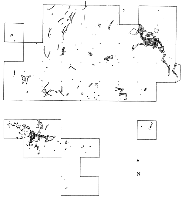
Investigations during June 2002 documented numerous articulated or partially articulated bison, including elements with a wide range of sizes, weights, and density. These excavations opened only small windows into the bonebed, but revealed articulated skeletons from the axial units to the distal extremities. In several cases, the limb elements were folded together rather than extended, suggesting that some animals had collapsed while standing, apparently in a playa or pond margin setting. It is possible that an embankment was present to the west and north of the bonebed that could have served as a partial containment or impediment to herd movement out of the playa. The actual method of containing or restraining the bison that enabled many to be killed while standing together remains to be determined. One possibility is that a narrow arroyo or gully at the edge of the playa produced a constriction in herd movement that was exploited by hunters.
The total number of bison represented in the bonebed is unknown, but likely represents at least several dozen animals. Our current estimate of the minimum number of individuals is not less than six, but this is based on field observation in a very limited portion of the bonebed. Our estimate does not include the area excavated by Buckner, who estimated seven bison in her first trench. For most of the bonebed, skeletons of multiple bison are overlapping. Currently no evidence is known for more than one layer of bone nor for more than one kill.
The faunal assemblage consists of bison of varied age groups from calves to old adults, with most elements of mature animals being relatively small, suggesting females. A few large males are present and numerous immature animals and calves are represented. A cow and calf herd with few adult males is indicated by our available sample, and such herd composition is consistent with a winter through spring kill event(s). Seasonality assessment through dental eruption and wear patterns will be completed in the near future. With the exception of elements that have been exposed along the bank of the creek, condition of the bones is generally good, with little evidence of surface weathering, root etching, or carnivore damage. These factors suggest rapid and fairly deep burial of at least parts of the bonebed. The few crania encountered are highly fragmentary, and this is probably due to their higher weathering profile and the longer period during which they would have been exposed to weathering prior to burial (see Todd and Rapson, 1999). Long bones, flat bones, and vertebrae are typically fractured due to shrink and swell of the surrounding matrix and pressure from overlying sediments. Orientation of elements appears not to have been strongly influenced, if at all, by stream action. Inclination of most elements is roughly horizontal, and the variation is not unexpected for a bonebed in what was a frequently wet substrate.
A concentration of burned bison bone less than 1 m in diameter, including some articulated limb elements, occurred near the center of the exposure. The function of this feature has not been determined, but it probably represents a small hearth area that was used during butchering and processing activities.
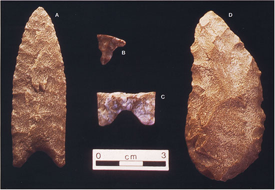
Lithic materials recovered from the Winger site include a few flakes, tools, and projectile points. Three lithic artifacts were found in the disturbed bonebed deposits that had been moved by heavy equipment prior to our investigations. These artifacts include a large bifacial thinning flake of Alibates flint, an ovate biface of locally available Dakota quartzite that may have served as a butchering tool (D in fig. 4-22), and the corner of an Allen point manufactured from Alibates flint (B in fig. 4-22). Within the bonebed we recovered (1) a unifacial flake tool which is triangular in cross section and could have served as a naturally backed knife, (2) a complete Dakota quartzite Allen point (A in fig. 4-22), and (3) the base of an Allen point made from Alibates (C in fig. 4-22). The point base was recovered from the western end of the bonebed at the base of the bone level, and the complete point was found near the eastern end of our excavation. The complete point was recovered in situ with the tip down at an oblique angle, at the bonebed level but just beyond the margin of the dense bone concentration. These artifacts compare well with Allen points recovered from the Norton site in west-central Kansas (Hofman, 1996, p. 73-74), which yielded a radiocarbon age on bone that is essentially identical to that from Winger.
Figure 4-22--Artifacts recovered during the June 2002 excavations at the Winger site. A, Allen point made from Dakota quartzite; B, corner of an Allen point; C, base of an Allen point made from Alibates; D, ovate biface made from Dakota quartzite.
The association of the Winger bonebed with pond deposits underscores the significance of playas as locations for human activities through time. As focal points for water, animal, and plant resources, playas were attractive to human groups in the High Plains environment.
Preliminary results of our investigations at Winger indicate that the site is significant in several respects. First, Winger is the largest intact bison kill/butchery site recorded in Kansas and probably the largest known in the region. The length of the Winger bone bed is similar to the Jones Miller site of Hell Gap age in eastern Colorado near the northwest corner of Kansas (Stanford, 1999), and it is more extensive and less disturbed than the Norton bonebed in west-central Kansas, which also yielded Allen points (Hofman, 1996). Like Winger, the available radiocarbon date for Norton is based on bone and indicates an age of just over 9,000 yrs B.P. for the Allen complex. The Burntwood Creek bison bonebed in the northwest corner of Kansas, originally investigated in 1922 and 1923 by paleontologists from the University of Kansas (see Hill et at, 1992), may originally have been more extensive than Winger, but it is unclear how much of the site remains intact. An Allen point has also been recovered from the Burntwood Creek bonebed, and the collagen fraction from a sample of clean rib fragments yielded an AMS 14C age of 9,055 ± 40 yrs B.P. (JSGS-A0728). The somewhat older 12 Mile Creek site in northwestern Kansas was a much smaller bonebed, of Folsom age, that can now be studied only through use of the existing museum collection at the University of Kansas (Hill, 1996). The Late Paleoindian Laird site in northwestern Kansas holds much potential but is much smaller than Winger. Laird yielded an unusual stemmed projectile point (Hofman and Blackmar, 1997), and it has a single bone collagen 14C age of 8,495 ± 40 (CAMS-82397) (Blackmar, 2002).
Second, the bonebed at Winger has undergone minimal disturbance since the time of the bison kill. Primary agents in bone modification have been the shrink-swell action of the playa sediments and the pressure of overlying deposits. Disturbance by carnivores or trampling by hoofed animals appears to be minimal based on surface conditions and orientation of elements. Element density and size is highly variable, with even fragile elements well represented. Bone surfaces are well preserved, except for numerous fractures. Evidence of butchering, dismemberment marks, and fractures can be readily identified and studied. As research progresses, evaluation of the nature and patterns of carcass utilization at the site will be made. The evaluation of butchering and processing behavior, element representation, and seasonality will be investigated in detail. This assemblage will provide a key for comparative studies of bison ecology and evolution for the early Holocene in the Central Plains.
In addition to its size and the quality of bone preservation, the Winger site provides us with an important opportunity to document an apparently unmixed, datable Allen assemblage from deeply buried, stratified deposits. This has not previously been possible, as all known Allen sites in the region have either been (1) shallow, near-surface deposits with mixed artifact assemblages potentially representing multiple technological traditions; (2) deeply buried but disturbed; or (3) without materials for reliable chronometric dating. At Winger, then, we have the potential to add substantially to our information and understanding of the Allen technological complex and the human use of, and decision-making at, an extensive early Holocene bison kill. Information gleaned from the site will also shed light on early Holocene paleoecology and bison ethology and evolution in the Central Plains of North America.
Birkeland, P. W., 1999, Soils and geomorphology (3rd ed.): Oxford, Oxford University Press, 430 p.
Blackmar, J. M., 2002, The Laird site: University of Kansas, Museum of Anthropology Newsletter, v. 65, p. 3.
Buckner, V., 1970, Kansas Anthropological Association archeological site report for site 14ST401: Kansas State Historical Society, Site Report files.
Buckner, V., 1973, Letter to Thomas Witty (dated November 12, 1973): Kansas State Historical Society, Site Report files.
Fenneman, N. M., 1931, Physiography of western United States: New York, McGraw-Hill.
Frye, J. C., 1950, Origin of Kansas Great Plains depressions: Kansas Geological Survey, Bulletin 86, part 1, 20 p. [available online]
Frye, J. C., and Leonard, A. B., 1951, Stratigraphy of late Pleistocene loesses of Kansas: Journal of Geology, v. 59, p. 287-305.
Frye, J. C., and Leonard, A. B., 1952, Pleistocene geology of Kansas: Kansas Geological Survey, Bulletin 99, 230 p. [available online]
Hill, M. E., Jr., 1996, Paleoindian bison remains from the 12 Mile Creek site in western Kansas: Plains Anthropologist, v. 41, p. 359-372.
Hill, M. E., Jr., Hofman, J. L., and Martin, L. D., 1992, A reinvestigation of the Burntwood Creek bison bonebed: Current Research in the Pleistocene, v. 9, p. 99-102.
Hofman, J. L., 1996, Early hunter-gatherers of the Central Great Plains-Paleoindian and Mesoindian (Archaic) cultures; in, Archaeology and Paleoecology of the Central Great Plains, J. L. Hofman, ed.: Fayetteville, Arkansas Archeological Survey, Arkansas Archeological Research Series 48, p. 41-100.
Hofman, J. L., and Blackmar, J. M., 1997, The Paleoindian Laird bison bone bed in northwestern Kansas: The Kansas Anthropologist, v. 18, p. 45-58.
Mandel, R. D., 2000, Lithostratigraphy and geochronology of playas on the High Plains of western Kansas: Geological Society of America, Annual Meeting, Reno, Nevada.
Mandel, R. D., and Hofman, J. L., 2003, Geoarchaeological investigations at the Winger Site--A Late Paleoindian bison bonebed in southwestern Kansas, U.S.A: Geoarchaeology--An International Journal, v. 18, p. 129-144.
Stanford, D. J., 1999, Analysis and interpretation of Hell Gap hunting strategies at the Jones-Miller site; in, Archaeology and Paleoecology of the Central Great Plains, J. L. Hofman, ed.: Fayetteville, Arkansas Archeological Survey, Arkansas Archeological Research Series 48, p. 437-454.
Todd, L. C., and Rapson, D. J., 1999, Formational analysis of bison bonebeds and interpretation of Paleo indian subsistence; in, Le Bison--Gibier et Moyen de Subsistence des homes du Paleolithique aux paleoindiens des Grandes Plaines, J-Ph. Burgal, F. David, J. G. Enloe, and J. Jaubert, eds.: Antibes, France, APDCA, p. 479-499.
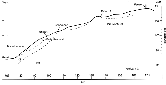
Stop 4 is at the Waugh Folsom site in northwestern Oklahoma (fig. 4-1). The Waugh site is located in Stockholm Canyon, a tributary of Buffalo Creek in Harper County (fig. 4-23). The site is situated in a narrow bottleneck near the upland divide between the Cimarron and Beaver (North Canadian) rivers. This is a common geomorphic setting for bison kill sites in the region.
Figure 4-23--Map showing the location of the Waugh site and other Folsom sites on the Southern Plains (from Hofman, 1995).
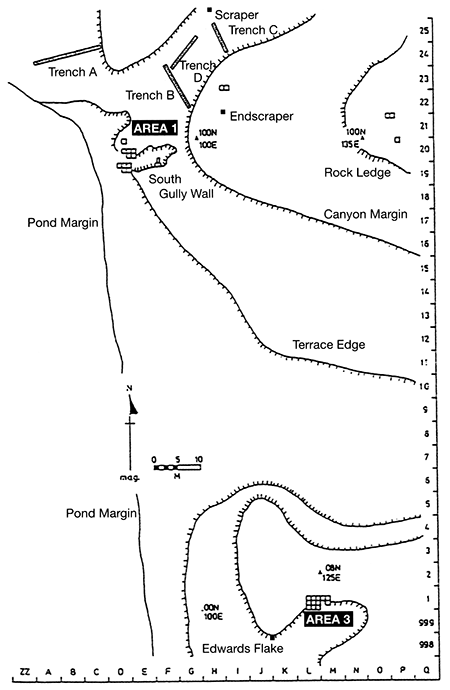
Stockholm Canyon is cut into the Permian-age sandstone of the Rush Springs Formation and drains to the north. Several exposures of late Pleistocene deposits occur along the margins of the canyon. One of these, designated Area 2, is on the west side of the canyon and dates to >25,000 yrs B.P. Area 2 has mammoth and a varied snail fauna. The Folsom components at Waugh, Areas 1 and 3, are located on the east side of the canyon (fig. 4-24). Area 1 was discovered first and is the northernmost of the areas.
Figure 4-24--Plan view of the 1990-93 excavations at the Waugh site showing Area 1 and Area 3 (from Hofman, 1995).
The Waugh site was discovered by Leland Waugh in January 1991. Excavations have been conducted with students from the University of Oklahoma, University of Kansas, Kansas State University, University of Missouri, and other institutions, and members of the Oklahoma Anthropological Society in 1991, 1992, 1993, 1996, and 2000. This research has been supported by the University of Kansas; the Oklahoma Archeological Survey; the Waugh families; the City of Buffalo, Oklahoma; the Buffalo Farmer's Co-op; and citizens of Harper County. Details pertaining to the site are in Hofman (1991a, 1991b, 1995, 1999), Hofman and Carter (1991), Hofman et al. (1992), Hill and Hofman (1997), and Widga and Hofman (2000).
Approximately 50 m2 have been excavated in Area 1 (fig. 4-24). Area 1 is interpreted as a bison kill and butchery locality with a minimum number of six bison, including three large bulls, two adult cow bison, and one juvenile bison (fig. 4-25). Season of the kill in Area 1 (based on tooth eruption and wear evidence from one animal that is 1.8 to 1.9 yrs old) is late winter to early spring. An unknown amount of the bonebed in the southwest portion of Area 1 was lost to erosion prior to discovery of the site. The densest concentration of bones representing at least four animals occurred in this area.
Figure 4-25--Plan view showing the distribution of bone in Area 1 at the Waugh site. Units are 1 x 1 m.
The bonebed in Area 1 was covered rapidly after the kill event, with some decomposition occurring after burial as indicated by reduced sediment under bones in some of the bone bed. Most bones, except some that are bleached and weathered due to recent exposure, lack root etching typical of shallowly buried bones. The eastern portion of the bonebed is more than 3 m below the modem land surface. The western portion of the bonebed is exposed at the surface and resulted in the discovery of the site (fig. 4-26).
Figure 4-26--Stratigraphy of Area 1 at at the Waugh site (from Hofman and Carter, 1991, p. 32). Unit 1 is early Holocene valley fill. Units 2 through 5 are alluvial fills post-dating Unit 1.
There is little evidence for carnivore activity (bone gnawing). Alluvial modification of bone orientation is evidenced in the northwest portion of Area 1, where a series of ribs are oriented north-south parallel to the streamflow. Also, some bones, apparently from the terrace above (east of) Area 1 have washed downslope and are contained in the colluvial fill covering the bonebed. Butchering cut marks occur on several bones. There is no evidence for marrow extraction; the long bones lack impact fractures.
Relatively few artifacts have been found in Area 1. These include one impact-damaged Folsom point of Edwards chert, one Folsom point tip with impact damage made of Alibates, an Edwards chert biface thinning flake, and a small retouch flake (fig. 4-27). The terrace above Area 1 (fig. 4-28) has yielded several lithic artifacts from what is interpreted as a processing and hide-working area. These artifacts include an endscraper of Niobrara jasper, a Folsom/Midland point preform made on a flake of Niobrara jasper, a convergent scraper of Alibates flint, and a wedge/scraper of Alibates flint (fig 4-27). These pieces have all been collected from the surface. Only 5 m2 have been excavated on the extensive Area 1 Terrace.
Figure 4-27--Dorsal view (A) and ventral view (B) of the artifacts collected at the Waugh site. A, fragment of Folsom point from Area 1; B, Folsom projectile point from Area 1; C, Folsom preform from terrace above Area 1; D, convergent scraper from terrace above Area 1; E, wedge from terrace above Area 1; F, endscraper from terrace above Area 1; G, spokeshave from Area 3; H, endscraper from Area 3, Hearth 1; I, flake tool from Area 3, Hearth 2.
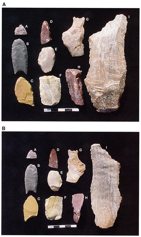
Figure 4-28--Valley cross section in Area 1 at the Waugh site.
Current interpretation for Area 1 is that it represents a small bison kill that occurred in an arroyo head-cut trap. These animals were butchered and processed during the late winter to early spring without evidence for use of the marrow which was probably in poor condition during that season. Carcass processing apparently emphasized meat, hides, and possibly extraction of some bones for technological needs.
Area 2 is located about 200 m south of Area 1 on the western side of the canyon. Investigations in 1991 and 1996 yielded evidence of a single mammoth. The bones are shallowly buried and stratigraphically above a late Pleistocene marsh/pond deposit. No evidence of cultural activity has so far been found in Area 2. A small fragment of mammoth long-bone was, however, found in Area 1 and a potential source for this specimen is the Area 2 mammoth.
Area 3 is located 100 m south of Area 1 and is also on the east side of Stockholm Canyon (fig. 4-24). It is at an elevation about 5.5 m higher than Area 1. This is in concordance with the canyon gradient and the slope of alluvial deposits at the time of occupation (10,400 14C yrs B.P.). The Area 3 Folsom level is about 3 m below the modern surface and is located to the northeast of a terminal Pleistocene marsh/pond which was drained by the headward erosion of Stockholm Canyon. A total of 36 m2 have been excavated in Area 2 since it was first investigated in 1992 (fig. 4-29).
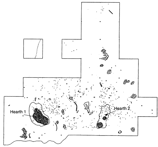
Figure 4-29--Plan view showing the distribution of hearths, charcoal, bone, and rock in Area 3 at the Waugh site. Units are 1 x 1 m.
Four lithic artifacts and two flakes have been recovered from the Area 3 Folsom level. Three artifacts are made of Alibates and include a spurred end-scraper, a spurred spokeshave or concave scraper, and a large flake knife (fig. 4-27). In addition, a large chopper of Day Creek Dolomite was also found. Each of these artifacts was found near a hearth. The flakes are of Alibates and Edwards chert. A few chipped stone pieces were found on the surface of the west slope of the terrace above the Folsom level. These include a bifacial Clear Fork gouge representing a later brief use of the location.
Bones in Area 3 include remains of at least two bison, one large bull and one juvenile, in addition to small mammal and possible bird bones. The bison bones may be derived from Area 1 bison, but this is inconclusive. Some bone working activity is indicated by a cut-out section from the blade of a bison scapula laying on the Folsom occupation surface in association with the scapula.
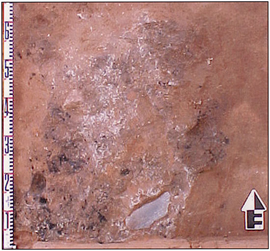
Two distinct hearth areas are present in Area 3. These contain ash and abundant charcoal and appear to be very shallow surface hearths (fig. 4-30). They were apparently covered soon after the occupation by alluvial silt and sand, leaving them intact and well preserved. The hearths are about 2.5 m apart. Hearth 1 included a burned bison sacrum with a bison cervical vertebrae series nearby. Also, there were two stone tools near the hearth. Hearth 2 (fig. 4-31) had two stone tools, including the largest artifact in fig. 4-27, and the cut scapula was nearby.
Figure 4-30--Profile view of Hearth 2, with large flake tool in situ. Arrow is pointing north.
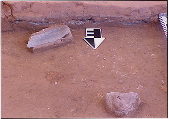
Figure 4-31--Plan view of the northern half of Hearth 2 in Area 3. The large flake tool is in situ. Arrow is pointing north.
A circular dark stain around Hearth 1 is similar in size and shape to a feature interpreted as a "structure" in the Folsom level at the Agate Basin site in Wyoming. A series of large sandstone rocks north of Hearth 2 may represent part of a Folsom-age structural feature in Area 3.
Two radiocarbon ages on charcoal from Hearth 1 average 10,390 ± 60 yrs B.P. Dates on the bison vertebrae from nearby are much younger at 9,160 ± 160 and 9,620 ± 70 yrs B.P. The ages determined on charcoal are assumed to be the best estimate of the time of Folsom activities in Area 3 at Waugh. At present there is no direct link (e.g., refit) between materials from Areas 1 and 3. Further dating is needed in all areas of the site and for the Pleistocene deposits below Area 2.
Lithic material sources at Waugh are primarily Alibates flint from the Texas Panhandle, but also represented are Edwards chert from central Texas, and Niobrara jasper from northwestern Kansas. These same materials are represented at the nearby Folsom-age Cooper bison bonebed (see Bement, 1999).
Continued research is needed in the eroded central portion of Area 1 to further determine the number of animals and individual elements, and to search for additional artifacts. Extensive shallow testing of the Area 1 Terrace to the east of the bonebed may provide important clues to secondary processing activities. Additional investigation of Area 3 is merited to better define the nature and limits of Folsom-age activities there. A much more extensive occupation surface is indicated by preliminary testing and erosional exposures in the area. Also, further investigation of Area 2 is needed to determine whether there is evidence for human involvement with the mammoth remains, and to glean paleoecological information from the marsh/pond deposits.
Geoarcheological, geochronological, and paleoecological studies are continuing in order to understand the site formational history and context of the Folsom activities at the Waugh site. Investigations to date have only provided an initial basis for interpreting the site's complex formation and depositional history.
Bement, L. C., 1999, Bison hunting at Cooper site: Norman, Oklahoma, University of Oklahoma Press, 227 p.
Hill, M. E., and Hofman, J. L., 1997, The Waugh site--A Folsom-age bison bonebed in northwestern Oklahoma: Plains Anthropologist, v. 42, Memoir 29, p. 63-83.
Hofman, J. L., 1991a, Sites, localities, and isolates--A regional perspective on Southern Plains Folsom evidence: Society for American Archaeology, New Orleans, 56th Annual Meeting (paper presentation).
Hofman, J. L., 1991b, The Waugh site--A Folsom bison kill in northwestern Oklahoma: Oklahoma Archeological Survey Newsletter, v. 10, no. 4, p. 1-2.
Hofman, J. L., 1995, Dating Folsom occupations on the Southern Plains--The Lipscomb and Waugh sites: Journal of Field Archeology, v. 22, p. 421-427.
Hofman, J. L., 1999. Unbounded hunters: Folsom bison hunting on the Southern Plains circa 10,500 yrs BP, the lithic evidence; in, Le Bison-Gibier et Moyen de Subsistance des Hommes du Paleolithique aux Paleoindiens des Grandes Plaines, J. P. Brugal, F. David, J. G. Enloe, and J. Jaubert, eds.: Antibes, France, Editions APDCA, p. 383-415.
Hofman, J. L., and Carter, B. J., 1991, The Waugh site--A Folsom bison association in northwestern Oklahoma; in, Guidebook of the 9th Annual Meeting, South-central Friends of the Pleistocene--A Prehistory of the Plains Border Region, B. J. Carter and P. A. Ward, eds.: Stillwater, Oklahoma State University, Agronomy Department, p. 24-37.
Hofman, J. L., Carter, B. J., and Hill, M. E., 1992, Folsom occupation at the Waugh site in northwestern Oklahoma: Current Research in the Pleistocene, v. 9, p. 22-25.
Widga, C., and Hofman, J. L., 2000, Recent investigations at the Waugh site, Oklahoma: Plains Anthropological and Midwest Archeological Conference, St. Paul, Minnesota (poster presentation).
*Article is excerpted with permission from Carter; B. J., and Bement, L. C: 2003, Geoarchaeology of the Cooper site, northwest Oklahoma--Evidence for multiple Folsom bison kills: Geoarchaeology--An International Journal, v. 18, no. 1, p. 115-127.
The Cooper site (34HP45) is a stratified Folsom bison kill site in northwestern Oklahoma (Bement, 1999; Carter and Bement, 1995,2003). The site is located on the north (left) floodplain margin of the Beaver (North Canadian) River (fig. 4-32). Bones eroding from deposits exposed along a bluff overlooking the Beaver River (fig. 4-33) were monitored for signs of cultural affiliation, and in 1993, the tip of a Folsom point was found. Excavations during the summer of 1993 and again in the summer of 1994 uncovered bison remains and Folsom artifacts within arroyo fill that had been truncated by the meandering of the Beaver River. Only a small portion of each bone bed remained intact (6 x 8 m), although additional bones and artifacts were in a secondary deposit on the floodplain immediately below the bluff edge. The bluff is composed of eolian fine-sandy loam, arroyo fill, and Permian bedrock. During arroyo aggregation, three Folsom bison kill events occurred. Soil formed in this arroyo fill during the late Holocene and was subsequently buried by eolian fine-sandy loam sediments. Detailed description of the site, its setting, excavation, and analyses have been presented elsewhere (Bement, 1999; Carter, 1999; Carter and Bement, 1995). Here, we present a more detailed description of the geoarcheological investigation as it bears on the definition and segregation of the three kill events.
Figure 4-32--Aerial photograph of the Cooper site vicinity at the end of the dirt-track road.
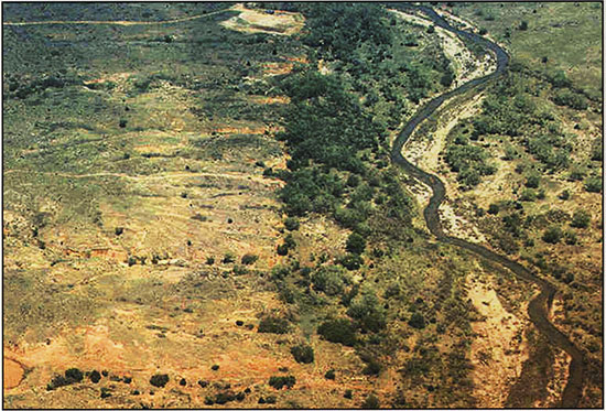
Figure 4-33--View of the upper bonebed exposed near the end of the 1993 field season. Buried bones associated with the middle bonebed are visible in the foreground.
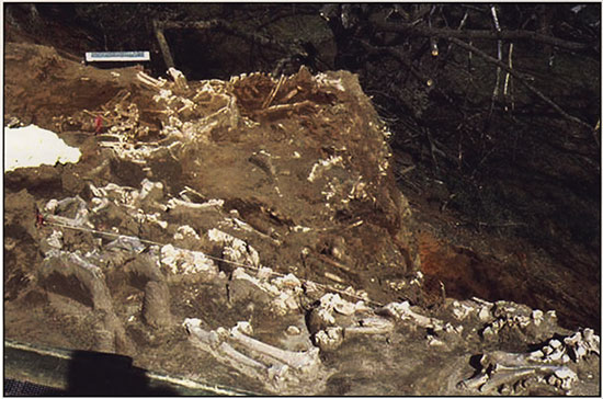
The Cooper site contains stratified fine-sandy loam, eolian and sandy loam alluvial sediments, and Permian bedrock. The Folsom bison kill materials are contained in arroyo-fill alluvium that overlies Permian bedrock.
A redoximorphic depletion zone beneath each bonebed indicates that the bison remains decomposed anaerobically. Sublayers were also identified within alluvial sediments and ranged in thickness from several to more than 30 cm (table 4-4). The sublayers indicate that the sediments aggraded by storm-water runoff. The alluvial sediments are buried by fine-sandy loam eolian sediments. Coarse fragments larger than fine gravels (2.0-5.0 mm) are not present (except bison bones and artifacts). The larger clasts within the sediments are limited to the bison bones (articulated skeletons), projectile points and uniface knives, and an occasional fist-sized cobble (11 in the upper kill, one in the middle, and one in the lower) distributed throughout the bonebeds. The distribution of the lithics, including the cobbles among the articulated skeletons, precludes their having been washed into the bonebed.
Two soils are found in the depositional sequence: (1) the modern soil formed in eolian sediments and (2) a buried soil formed in alluvium that dates to 1,100 yrs B.P. Deposition of the alluvium containing the bison bone beds had ended by the late Holocene as evidenced by this period of soil formation.
Table 4-4--Soil-profile description of a south-facing exposure at the Cooper site.a
| Horizonb | Depth (cm) |
Color Moist |
Structure | Texture | Consistence | Boundary | Reaction | Special Features |
|---|---|---|---|---|---|---|---|---|
| A | 0-15 | 10YR4/3 | 1,m,GR | FSL | vfr | c,s | eolian sand; My, f + m roots; Fw, c, krotovinas | |
| C | 15-75 | 10YR6/3 | M | FSL | vfr | a,s | ste | eolian sand; My, f + m roots; Fw, c, krotovinas |
| 2Ab | 75-81 | 7.5YR3/4 | 2,f,SBK | SL | fr | g,d | ste | alluvium (arroyo fill); Fw, f + m roots; My, fworm casts; Fw, c, krotovinas |
| 2Btk1b | 81-89 | 7.5YR4/3 | 2,m,SBK | SL | fr | c,s | ve | alluvium (arroyo fill); Fw, f + m roots; My, f worm casts; Fw, c, krotovinas |
| 2Btk2b | 89-118 | 5YR4/6 | 2,c,PRl2,m | SCL | fr | c,s | ve | alluvium (arroyo fill); Fw, f + m roots; My, m CaCO3 softbodies as threads and ped coatings; Fw, c, krotovinas |
| 2Bkb | 118-170 | 7.5YR4/3 | 2,c,PRl2,m | SBK | SL | fr | ve | alluvium (arroyo fill); Fw, f + roots; My, m CaCO3 softbodies as threads and ped coatings; Fw, m CaCO3 nodules; Fw, c, krotovinas |
| Upper bonebed (2C1b) consists of three subhorizons: 2C11b, 2C12b, and 2Cg1b | ||||||||
| 2C11b | 170-189 | 5YR4/4 | M | SL | vfr | a,s | ste | alluvium (arroyo fill); Fw, f + m roots; Fw, rounded quartzite fine gravels; Fw angular Permian red-bed fine gravels; Fw, c, krotovinas; finely stratified layers of L, SL, S, and LS |
| 2C12b | 189-200 | 2.5Y7/4 | M | vfr | a,s | ste | articulated bison bones; slight to moderate weathered surfaces; few scavenger marks; projectile points; uniface knives; large cobbles | |
| 2Cg1b | 200-204 | 5YR6/2 | M | SL | fr | a,s | ste | pinkish-gray, redoximorphic depletion area |
| Middle bonebed (2C2b) consists of three subhorizons: 2C21b, 2C22b, and 2Cg2b | ||||||||
| 2C21b | 204-224 | 5YR4/4 | M | SL | vfr | a,s | ste | alluvium (arroyo fill); Fw, f + m roots; Fw rounded quartzite fine gravels; Fw angular Permian red-bed fine gravels; Fw, c, krotovinas; finely stratified layers of L, SL, S, and LS |
| 2C22b | 224-234 | 2.5Y7/4 | M | vfr | a,s | ste | articulated bison bones; slight to moderate weathered surfaces, few scavenger marks; projectile points; uniface knives; large cobble; trampling damage to bones along western edge; painted bison skull exposed at base of bone bed | |
| 2Cg2b | 234-239 | 5YR6/2 | M | SL | fr | a,s | ste | pinkish-gray, redoximorphic depletion area |
| Lower bonebed (2C3b) consists of three subhorizons: 2C31b, 2C32b, and 2Cg3b | ||||||||
| 2C31b | 239-258 | 5YR4/4 | M | SL | vfr | a,s | ste | alluvium (arroyo fill); Fw, f + m roots; Fw rounded quartzite fine gravels; Fw angular Permian red-bed fine gravels; Fw, c, krotovinas; finely stratified layers of L, SL, S, and LS |
| 2C32b | 258-269 | 2.5Y7/4 | M | vfr | a,s | ste | articulated bison bones; slight to moderate weathered surfaces; few scavenger marks; projectile points; uniface knives; large cobble; trampling damage to bones in central and eastern bone bed; painted bison skull protrudes into 2C22,b bone bed | |
| 2Cg3b | 269-274 | 5YR6/2 | M | SL | fr | a,s | ste | pink-gray, redoximorphic depletion area |
| 2C42b | 274-332 | 5YR4/4 | M | GSL | vfr | a,s | ste | alluvium (arroyo fill); Fw, f + m roots; Fw, rounded quartzite fine gravels; Fw angular Permian red-bed fine gravels; Fw, c, krotovinas |
| 2C52b | 332-379 | 5YR4/6 | M | LVCoS | vfr | a,d | ste | alluvium (arroyo fill); Fw, f + m roots; Fw, rounded quartzite fine gravels; Fw angular Permian red-bed fine gravels; Fw, c, krotovinas |
| 2C62b | 379-400 | 5YR4/4 | M | CoSL | vfr | a,w | ve | alluvium (arroyo fill); Fw, f + m roots; Fw, rounded quartzite fine gravels; Fw, c, krotovinas |
| 3Cr2b | 400-418 | 2.5YR4/6 | l,m,SBK | SiL | fi | g,s | ste | Fw, f, roots; Fw, black Fe + Mn oxide coatings on joints and fractures of weathered Permian shale and sandstone; Fw, c, krotovinas |
| 3R1b | 418-455 | 2.5YR4/4 | M | VFSL | exh | g,s | e | Permian shale and sandstone (weakly consolidated); Fw, f, roots |
| 3R2b | 455-530+ | 2.5YR4/6 | M | LVFS | exh | ste | Permian shale and sandstone (weakly consolidated); Fw, f, roots | |
|
astructure: 1 = weak, 2 = moderate, f = fine, m = medium, c = coarse, GR = granular, SBK = subangular blocky, PR = prismatic, / = parting to. Texture: F = fine, Co = coarse, V = very, S = sand, Si = silt, L = loam, C = clay, G = gravelly. Consistence: v = very, fr = friable, fi = firm, exh = extremely hard. Boundary: a = abrupt, g = gradual, c = clear, s = smooth, d = discontinuous, w = wavy. Reaction: st = strongly, v = violently, e = effervescence. Special features: My = many, Fw = few, f= fine, m = medium, c = coarse (Soil Survey Division Staff, 1993). bHorizon designations follow Soil Survey Division Staff (1993) except for subdivision of 2C1b, 2C2b, and 2C3b horizons into subhorizons. These changes were made to assist in the explanation of soil material adjunct to each bonebed and clearly identify buried-soil horizons. |
||||||||
Each bonebed is separated by an average of 20 cm of finely stratified arroyo fill (fig. 4-34). The bonebeds do intermingle where sedimentation had not completely buried the bones of the earlier event, especially along the east and north bone bed margins between the lower and middle bonebeds and the west bonebed margin between the middle and upper bonebeds. Bonebed diagenesis includes gray redoximorphic zones (2C11b, 2C12b, and 2C13b) immediately below the bonebeds (2C12b, 2C22b, and 2C32b). These gray iron oxide depletion zones formed as organic matter from bison remains was decomposed by soil microorganisms under anaerobic conditions. Bison remains decomposed by micro-organisms represent those left in contact with the soil and not taken by bison hunters. The redoximorphic depletion areas probably formed weeks to months after each kill occurred (see Daniels and Buol, 1992; Obenhuber and Lowrance, 1991; Dobos et al., 1990; Vepraskas and Wilding, 1983; Vepraskas and Bouma, 1976).
Figure 4-34--Photograph of the laminated sediments between the middle and upper bonebeds at Cooper.
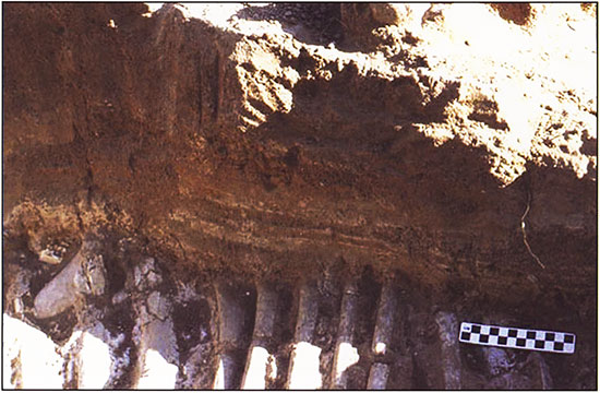
Several key observations were made during the excavations that aided in the segregation of skeletons into their respective stratigraphic levels and provide rough estimates of time between kill events. The first and most obvious was the articulated condition of the skeletons such that intermingled extremities from different animals within the same bonebed could be sorted out by following an articulated element toward other body parts. Even when bonebeds were adjacent and overlapped, individual bison remains could be attributed to one of the three distinct bonebeds. If, for example, the leg was from a lower kill episode, then the leg would eventually dip, allowing vertical separation from the upper-level carcasses. This was most visible along the western edge of the site along the steep arroyo wall in the overlap of middle and upper kill skeletons. A second zone of overlap, this time between the lowest and middle kill skeletons, was identified near the north and east edge of the bonebeds.
A second observation in excavating the upper and middle kill overlap was that bones in the intermingled zone that were articulated to animals of the lower level displayed oval to round fractures (Bement, 1999, p. 28, 30-31). The character of the fractures was somewhere midway between green-bone breaks (possible only during or immediately following the death of the animal) and dry-bone breaks (where the fracture follows the cracks that develop years after death). The size and shape of the circular fractures were interpreted as trample breaks caused by the bison of a later kill episode stomping on the exposed bones of a previous episode. A similar series of fractures were found on some of the bones in the lowest kill episode (Bement, 1999, p. 36-37), including the painted bison skull (Bement, 1999, p. 176-178). The trample fractures provide a rough estimate of the interval between kill episodes at the site. The fact that the breaks are not green-bone fractures indicates that a period of several months to a year must have elapsed between kill episodes. Similarly, because the fractures are not dry-bone breaks, the time span is less than 10 yrs in duration (see Bonnichsen and Sorg, 1989; Fiorillo, 1989). Because these figures are based on modern conditions, to extrapolate the rate of drying and cracking back in time, we must consider environmental conditions 10,500 yrs ago. If we assume conditions were cooler and perhaps more moist than today, the rate of bone drying and cracking would be comparatively slower than today and hence, a longer interval between kill episodes would be indicated. Conversely, if conditions were warmer and drier than today, the interval between kills would tend toward a shorter time span between events.
In addition to the trampling evidence, the bones from each layer were rated for extent of weathering, following the procedures of Behrensmeyer (1978). The identification of weathered bone surfaces up to stage three (out of six) in all three bone beds indicates the bones were exposed on the surface for varying lengths of time before burial (Bement, 1999, p. 131-133), but none was exposed to the point of extensive degradation. The upper surfaces of the uppermost bones in each bone bed exhibited the highest degree of weathering while lower bones in each bonebed displayed less evidence of weathering on both upper and lower surfaces. The end result, then, is a sequence of minimally weathered bones overlain by moderately weathered bones in each kill episode.
Carnivore modification was found on bones from all three kills, with the highest incidence occurring in the lowest kill bonebed followed by the upper kill and then the middle kill (Bement, 1999, p. 133). Although the presence of carnivore gnawing does not provide an estimate of time, it does support the stratigraphic break between kill episodes because such activity can only occur while the carcasses are exposed on the surface. Scavenging activity would cease when the bones were buried by arroyo fill or by the carcasses of a later kill event.
The age distribution of the bison (based on tooth eruption and wear patterns) in all three kills points to a late summer/early fall season of death. This situation suggests that at least one year elapsed between kill episodes. However, several years could elapse between kill events and produce the same pattern as long as each event occurred during the same season of the year.
Cultural modification of the bonebeds was limited to the span of time encompassing and immediately following each kill and consists of damage caused by the projectile points and the butchering tools. The presence of cut marks and various punctures and fractures on bones from each kill indicate animals in all three events were butchered and that similar butchering techniques were employed on all three occasions (Bement, 1999, p. 129-131, 137). The only evidence of pre-kill activity occurred prior to the middle kill with the painting of an exposed lowest kill bison skull.
The geoarcheological investigation of the Cooper site indicates three bison kills were buried by alluvium in the bottom of an aggrading arroyo during Folsom time. The finely stratified sandy loam sediments separating the bonebeds characterized the arroyo fill. The stratified sandy loam alluvium indicates the three bison kills are contained in sediments derived from storm-water runoff. Lack of soil formation within the alluvium, except for redoximorphic depletion areas below each bonebed and evidence from bone characteristics (based on bison tooth eruption and wear pattern) and weathering (based on the degree of weathering and trample-fracture pattern on the bones), indicate that each bison kill occurred at intervals of at least a year apart and probably less than 10 years. Clasts larger than clay, silt, sand, and fine gravel were culturally introduced into the arroyo in the form of Folsom bison kill and butchering materials. Arroyo filling stopped at least by the late Holocene as evidenced by a soil formed at the top of the alluvium and subsequently buried by eolian sediments.
This work was supported by the National Geographic Society; Oklahoma Archeological Survey, University of Oklahoma; Oklahoma Anthropological Society; Convenience Products of Fenton, Missouri; Oklahoma Department of Wildlife Conservation; Oklahoma Agricultural Experiment Station, Division of Agricultural Sciences and Natural Resources at the Oklahoma State University; and private donations.
Behrensmeyer, A. K., 1978, Taphonomic and ecologic information from bone weathering: Paleobiology, v. 4, no. 2, p. 150-162.
Bement, L. C., 1999, Bison hunting at Cooper site--Where lightning bolts drew thundering herds: Norman, University of Oklahoma Press.
Bonnichsen, R., and Sorg, M. H., 1989, Bone modifications: Orono, Maine, Center for the Study of the First Americans, 535 p.
Buol, S. W., Hole, F. D., McCracken, R. J., and Southard, R. J., 1997, Soil genesis and classification, 4th ed.: Ames, Iowa State University Press, 527 p.
Carter, B. J., 1999, Soils and landscape features; in, Bison Hunting at Cooper Site--Where Lightning Bolts Drew Thundering Herds, L. Bement: Norman, University of Oklahoma Press, p. 45-51.
Carter, B. J., and Bement, L. C., 1995, Soil investigations at the Cooper site: Current Research in the Pleistocene, v. 12, p. 119-121.
Carter, B. J., and Bement, L. C., 2003, Geoarchaeology of the Cooper site, northwest Oklahoma--Evidence for multiple Folsom bison kills: Geoarchaeology--An International Journal, v. 18, no. I, p. 115-127.
Daniels, R. B., and Buol, S. W., 1992, Water-table dynamics and significance to soil genesis; in, Proceedings of the Eighth International Soil Correlation Meeting (VIII ISCOM)--Characterization, Classification, and Utilization of Wet Soils, J. M. Kimble, ed.: U.S. Department of Agriculture, Soil Conservation Service, and U.S. AID, Washington, D.C., p.66-74.
Dobos, R. R., Ciolkosz, E. J., and Waltman, W. J., 1990, The effect of organic carbon, temperature, time, and redox conditions on soil color: Soil Science, v. 150, p. 506-512.
Fiorillo, A. R., 1989, An experimental study of trampling--Implications for the fossil record; in, Bone Modifications, R. Bonnichsen and M. H. Sorg, eds.: Orono, Maine, Center for the Study of the First Americans, p. 61-72.
Hall, G. F., Daniels, R. B., and Foss, J. E., 1982, Rate of soil formation and renewal in the USA; in, Determination of Soil Loss Tolerance, D. Kral, ed.: Madison, Wisconsin, American Society of Agronomy, Special Publication 45, p. 23-39.
Obenhuber, D. C., and Lowrance, D., 1991, Reduction of nitrate in aquifer microcosms by carbon additions: Journal of Environmental Quality, v, 20, p. 255-258.
Soil Survey Division Staff, 1993, Soil survey manual: U.S. Department of Agriculture, Handbook No. 18,437 p.
Vepraskas, M. J., and Bouma, J., 1976, Model experiments on mottle formation simulating field conditions: Geoderma, v. 15, p. 217-230.
Vepraskas, M. J., and Wilding, L. P., 1983, Albic neoskeletans in argillic horizons as indices of seasonal saturation and iron reduction: Soil Science Society of America, Journal, v. 47, p. 1,202-1,208.
Paper presented at the 2003 SAA meetings, Milwaukee, Wisconsin, April 2003.
Recent excavations in gullies along the Beaver River of northwest Oklahoma have unearthed the Jake Bluff site, an apparent Clovis-age bison kill (fig. 4-35). On the southern Plains of North America, the period between 12,000 and 10,000 radiocarbon years before present (yrs B.P.) is generally considered the Pleistocene/Holocene transition and is marked by rapidly changing climatic conditions, flora and faunal associations, and cultures. Whether the extinction of the mammoth and other megafauna species was due to changing environments (Grayson, 1989; Graham and Lundelius, 1984), overkill by human predation (Martin, 1984), or a combination of both (Stanford, 1999), the result was that hunters on the southern Plains of North America had to adapt to hunting the remaining mammal species-principally bison. Our best studied aspects of Clovis hunters are directed toward mammoth hunting with only a secondary, cursory understanding of Clovis bison hunting.
Figure 4-35--Location map of the Jake Bluff site in northwest Oklahoma.
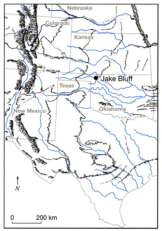
A search of the literature failed to find a model of Clovis bison hunting except for the "opportunistic" taking of large animals near water sources in what is otherwise a generalist subsistence strategy (Meltzer, 1993). Conversely, five models have been proposed for Clovis mammoth hunting (Saunders 1992, p. 133-138). These include the scavenger model (Sellards, 1952), age-selective cull model (Haury et al., 1959), herd stampede model (Haynes, 1966), herd confrontation model (Stevens, 1973; Saunders, 1977, 1980), and opportunistic culling model (Frison, 1978, 1988; Frison and Todd, 1986). Among the Clovis mammoth hunting models are communal hunting scenarios where groups of hunters acted in unison toward the planned trapping and killing of mammoths. If Clovis mammoth hunting included communal hunting techniques, then the development of bison communal hunting techniques is a logical progression, especially following mammoth extinction. Bison, as well as horse and camel remains, occur at Clovis sites including postulated bison kills at Murray Springs (MNI = 6, Hemmings, 1970) Clovis (MNI = 7, Hester, 1972; MNI = minimum number of individuals), and at or near Aubrey (Ferring, 1989). Whether these kills represent opportunistic harvesting of bison near water sources or utilization of some other landform is not fully discussed. However, the presence at Jake Bluff of bison remains in a narrow, deep arroyo suggests the employment of a deliberate, planned (if not communal) utilization of this landform to trap a group of bison.
During the 1994 excavation of the Folsom-age Cooper site, northwest Oklahoma (Bement, 1999), crew members discovered bison bones eroding from the side of a modern arroyo only 400 m upstream from the site. Initial assessment found only a handful of bison bones under a drape of late Holocene dune sand. No cultural material was found at that time. In 1998, a 1.5 x 0.5 m section of the bone deposit was uncovered to obtain samples for radiocarbon dating and species identification (Bement and Brosowske, 1999). The bone sample yielded a modern age that was at odds with the species identification of Bison antiquus, a late Pleistocene/early Holocene bison species. The stable carbon isotope ratio of -26.1 parts per mil for the dated bone suggested the sample was contaminated by modern plant material. A second sample was submitted. This sample, however, did not contain sufficient carbon for a radiocarbon assay-a condition more in line with the suspected Pleistocene age indicated by the Bison antiquus species identification.
The 1998 testing program determined the bones lay on top of bedrock. A chert flake found in the bison bone pile on the bedrock bench provided evidence of human association with the bison remains and the site was recorded as 34HP60, the Jake Bluff site. Subsequent monitoring of the gully exposure yielded two additional flakes and a unifacial flake knife-all of local lithic material. Coring in the area immediately east of this bone pile revealed a 3-m-deep gully. The core removed a piece of bison bone from the depths of this arroyo. Subsequent hand auguring, however, failed to extend the arroyo.
To determine the relationship of the bone deposit and adjacent buried arroyo, three weeks of excavation were conducted during the summer of 2001. This effort included the excavation of a 2 x 1.5-m area of the bone deposit and three 1 x 4-m trenches across the suspected long axis of the arroyo. The block excavation on the bone deposit uncovered the butchered legs of at least three bison. Although dominated by leg elements, the pile also contained a pair of mandibles from a juvenile (3.3-yr-old) bison bull. The tooth eruption and wear pattern identified the season of death as late summer/early fall-identical to that at the nearby Folsom-age kills at the Cooper site. The three trenches confirmed the existence of the arroyo and uncovered bison bone at the bottom, including the mandible from a 4.3-yr-old bison cow. A radiocarbon assay of 10,750 ± 40 (CAMS-79940) on a tooth from the bottom of the central trench suggested an early Folsom age for this site. Based on the radiocarbon date, presence of a buried gully containing bison remains, recovery of flakes and a flake knife, and the late summer/early fall seasonality of the kill, the Jake Bluff site was proposed to be an early Folsom bison kill similar to the three kills at the nearby Cooper site (Bement, 1999).
With funding from the National Geographic Society (Grant #7283-02), excavation was undertaken in 2002 to uncover additional areas within the arroyo, explore the eastern bedrock rim, and obtain additional datable materials and diagnostic projectile points (fig. 4-36). Information from Jake Bluffwas intended to address a model of Folsom bison-kill organization developed from the excavation of the Cooper site. The presence of three large bison kills in a single gully at the Cooper site raised the possibility for additional kills in other gullies along this stretch of the Beaver River. It was anticipated that the Jake Bluff site was, like the three kills at the Cooper site, a late summer/early fall, large arroyo trap kill along the eastern margin of the southern Plains.
Figure 4-36--A 3-D and profile layout of the Jake Bluff gully.
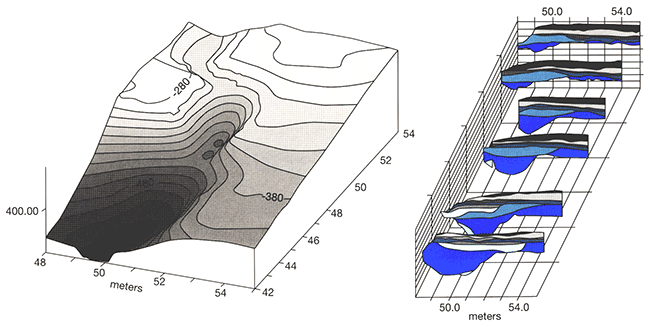
The six-week-long 2002 excavation opened three wide trenches (2 x 6 m) that extended across and onto the eastern bedrock rim of the arroyo. Lateral extensions of these trenches brought the total excavated area to 40 m2 including a total of 8 m along the arroyo floor.
The gully was found to extend for at least 20 m and was surprisingly narrow (fig. 4-36). The 2-m-wide gully had the appearance of an eroded animal trail incised into the soft sandstone bedrock (fig. 4-37). The excavation across the gully axis identified five zones. Zone I is Permian-age sandstone bedrock. Zone II is the gully fill containing the bison bones and artifacts. Zone III is an erosional cut-and-fill event that removed a portion of Zone II and replaced it with coarse sand. An attempt to date this event failed. The hackberry seeds selected for dating appear to be intrusive into the deposit. Zone IV may be the upward-fining of sediments from the Zone III event or an independent depositional event. Pedogenesis in Zone IV reflects stability on this landform around 500 14C yrs B.P. Zone V is eolian sand sourced from the Beaver River floodplain alluvium.
Figure 4-37--East-west profile across the gully.
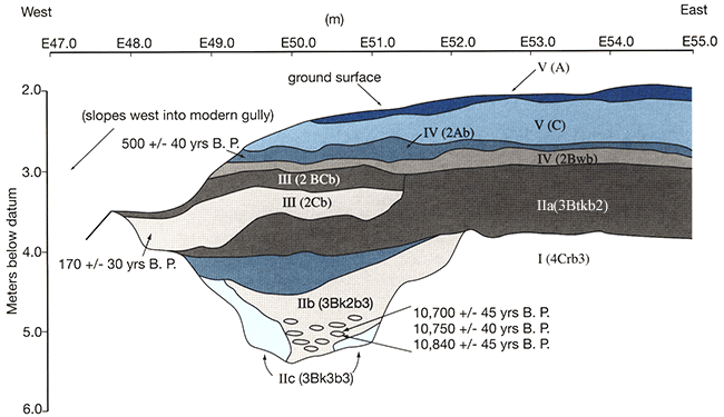
The bison remains in the arroyo brought the overall site minimum number of individuals (MNI) to 15 animals (table 4-5). Preliminary analysis suggests the herd consisted of cows, calves, and juveniles. The eastern bedrock rim failed to yield a processing pile such as that seen on the western rim. However, a scatter of broken bones, resharpening flakes, cobble-size hammer stones, and one possible anvil stone indicates processing activities were present.
Table 4-5--Field count and minimum number of individuals at Jake Bluff site.
| Element | 2001 N=MNI |
2002 N=MNI |
Total N=MNI |
|---|---|---|---|
| Humerus | 13 7 | 12 6 | 25 13 |
| Radius | 15 8 | 8 4 | 23 12 |
| Ulna | 7 4 | 5 3 | 12 6 |
| Metacarpal | 10 5 | 10 5 | 20 10 |
| Femur | 16 8 | 14 7 | 30 15 |
| Tibia | 13 7 | 12 6 | 25 13 |
| Astragalus | 9 5 | 7 4 | 16 8 |
| Metatarsal | 8 4 | 8 4 | 16 8 |
The bone deposits in the bottom of the arroyo contained resharpening flakes, additional cobble-size hammer stones, and two Clovis projectile points (fig. 4-38). Both projectile points are made of Alibates agatized dolomite and display a single flute on each face (fig. 4-39). One has been reworked from a much larger point (now L = 5.13 cm, W = 2.59, T = 0.74), the other is similar to the Clovis type II defined by Hester (1972) at Blackwater Draw and is rather diminutive (L = 4.25 cm, W = 1.75, T = 0.57).
Figure 4-38--Two Clovis-style projectile points were discovered in this bone pile on the gully floor.
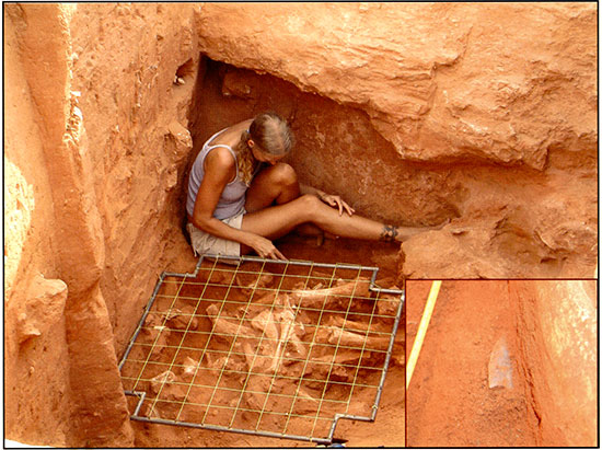
Figure 4-39--Drawings of both projectile points from the Jake Bluff site.
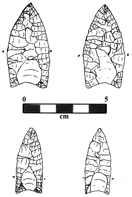
Workmanship on both specimens is similar to other southern Plains Clovis (Hofman and Wyckoff, 1991). Fine-pressure retouch on the larger point is reminiscent of the workmanship on the Clovis points from the Domebo mammoth kill in central Oklahoma (Leonhardy, 1966) and apparently also resembles specimens from the Mockingbird Gap site in New Mexico--an assemblage believed to fall intermediate between Clovis and Folsom (Stanford, 1999). Basal characteristics place both points in the middle of the range of western Clovis points as discussed by Morrow and Morrow (2002).
The recovery of two Clovis points in direct association with bison remains in the bottom of the arroyo brought new implications to the site. First, it indicated that Jake Bluffwas not a Folsom site. Second, there are few Clovis bison kills known (Hemmings, 1970; Hester, 1972). Third, the radiocarbon date of 10,750 ± 40 yrs B.P. suggested the site may post-date mammoth extinction. It was clear that the dating of Jake Bluffwas ofutrnost importance. The evaluation of the initial radiocarbon date and submission of additional samples became the priority of analysis. The first age was obtained from XAD purified collagen from an upper molar recovered from the bottom of the arroyo in 200 I. Two additional bone samples were submitted to Stafford Labs for similar processing. This time, a small, dense skull bone known as the petrous was selected from the 2002 excavations. Recent amino acid preservation analysis on a suite of bones from the Cooper site concluded that the petrous contained the least altered amino acids of all bones sampled (Stafford and Bement, n.d.). Because Jake Bluff is only 400 m from Cooper and both sites are in gullies along the same landform remnant of the Beaver River, it was felt that the petrous from Jake Bluff might also be well preserved. Subsequent amino acid analysis of two Jake Bluffpetrous bones from the arroyo deposits showed them to be as well preserved as the Cooper petrous. The resultant radiocarbon ages of 10,840 ± 45 and 10,700 ± 45 yrs B.P. (CAMS-90968 and 90969, respectively) provide confirmation of the late age of this site (table 4-6). Combining these two dates with the previous Jake Bluff date yielded an average of 10,754 ± 83 yrs B.P.
Table 4-6--Jake Bluff radiocarbon dates.
| Lab ID | Material | 14C yrs B.P.a |
|---|---|---|
| Beta-170045 | Decalcified Soil Carbon | 500±40 |
| Beta-170044 | Hackberry Seeds | 170±30b |
| CAMS-79940 | Tooth-XAD Collagen | 10,750±40 |
| CAMS-90968 | Petrous-XAD Collagen | 10,840±45 |
| CAMS-90969 | Petrous-XAD Collagen | 10,700±45 |
| aRadiocarbon years before present bIntrusive material |
||
It is logical that Clovis hunters would turn to bison hunting as mammoths and other megafauna became scarce. In fact, following analysis of the Murray Springs materials, Hemmings (1970) presented the hypothesis that as Clovis hunters turned to pursuit of bison, the Clovis projectile would undergo a concomitant reduction in size (see Bonnichsen et al., 1987, p. 421, for a similar prediction). Hemmings' subsequent analysis, comparing point size from mammoth and bison contexts, however, did not support this hypothesis, as some of the smallest points were associated with mammoth and some larger points with bison (Hemmings, 1970). It is not clear, however, that the Clovis bison associations analyzed by Hemmings post-dated mammoth extinction-generally accepted at ca. 10,800 14C yrs B.P. (Bonnichsen et al., 1987; Mead and Meltzer, 1985). In fact, Haynes (1993, p. 227) considers the mammoth kill at Murray Springs to be the last in the stratigraphic sequence. The presence in the Mockingbird Gap site assemblage of projectile points with characteristics intermediate between Clovis and Folsom types may be evidence of this shift (Stanford, 1999, p. 296). However, without the recovery of datable materials, this site cannot be positively placed in an intermediate time frame between Clovis and Folsom.
Perhaps the post-mammoth adaptation is seen first in the techniques of bison hunting and later in stone use. It is proposed here that it is the method of taking bison that changes from the opportunistic harvesting of one to several animals around water holes to include the deliberate trapping of larger numbers of animals, allowing harvesting of 10+ animals at a time. The arroyo trap technique would be a logical outcome that allows maximum numbers of animals killed with a minimum chance of risk, either in the failure of the overall hunt or risk of bodily harm to the hunters themselves (Meltzer, 1993, p. 30 I). The arroyo trap would not replace the small kill at pondside but rather would be added as an alternative for situations when large numbers of animals and the required arroyos were available to the appropriate number of hunters. The postmammoth-extinction Clovis bison kills could include both small kills, possibly around watering areas, and larger kills in arroyos.
A similar dichotomy in bison-kill size has been postulated for Folsom times where small numbers (<6) of animals are taken near water sources while larger kills (>10) are found in arroyo traps (Bement, 1999). Concomitant with the dichotorny in kill size during the Folsom Period is a seasonal dichotomy where the large arroyo traps occur only during the late summer/early fall season while small kills occur throughout the year. Interestingly, the bison (MNI = 15) killed in the Jake Bluff arroyo indicate a late summer/early fall seasonality of death-the same as that seen at the three Cooper kills only 400 m away and 250 yrs later. Is Jake Bluff a Clovis precursor of the pattern seen during the Folsom Period?
Stemming from this discussion, then, is the hypothesis that the Jake Bluff site is a late-Clovis adaptation to bison hunting. As a consequence, it is predicted that possible shifts in the lithic technology toward that of later Folsom adaptations may exist in the lithic assemblage from Jake Bluff. Finally, is it a coincidence that the Jake Bluff arroyo is among a number of paleo-arroyos including the Cooper arroyo, preserved along this 3-km-long landform segment on the north side of the Beaver River? Perhaps there are additional Paleoindian bison kills awaiting discovery in nearby gullies. Continued work at the Jake Bluff site includes the analysis of lithic technology, butchering technology, landscape evolution, seasonality, and the search for a nearby camp.
In summary, the importance of this research is seen at the level of the site and what it has to say about a specific bison-hunting event and subsequent processing of the kill. Beyond this, the late Clovis age indicated by the radiocarbon dates suggests the site post-dates mammoth extinction. As such, Jake Bluff can offer insights into the development of Clovis hunting techniques and organization pertaining to bison hunting at the scale seen in subsequent Folsom bison kills. This project expands the geornorphological investigation of the Pleistocene/Holocene transition from the ponded water and draws settings into the short gullies found on valley margins. The expansion of investigation into new landforms follows the expansion of hunting tactics employed first by Clovis and later by Folsom groups on the southern Plains of North America. Whether or not the change in location of bison kills was prompted by the extinction of mammoths or simply the fortuitous archeological investigation of this landform, this project is the first to investigate arroyo-style bison hunting techniques of Clovis hunters.
This project was funded in part by National Geographic CRE Grant #7283-02, the University of Oklahoma, Oklahoma Archeological Survey, Oklahoma State University, Oklahoma Anthropological Society, and private donations.
Bement, L. C., 1999, Bison hunting at Cooper site--Where lightning bolts drew thundering herds: University of Oklahoma Press, Norman, 227 p.
Bement, L. C; and Brosowske, S. D., 1999, Paleoindian bison hunting along the Beaver River, Harper County, Oklahoma: Oklahoma Archeological Survey, Norman, Archeological Resource Survey Report No. 40, 57 p.
Bonnichsen, R., Stanford, D., and Fastook, J. L., 1987, Environmental change and developmental history of human adaptive patterns--The Paleoindian case; in, North America and Adjacent Oceans During the Last Deglaciation, W. F. Ruddiman and H. E. Wright, Jr., eds.: Geological Society of America, The Geology of North America, v. K-3, p. 403-424.
Ferring, C. R., 1989, The Aubrey Clovis site--A Paleoindian locality in the Upper Trinity River basin, Texas: Current Research in the Pleistocene, v. 6, p. 9-11.
Frison, G. C., 1978, Prehistoric hunters of the High Plains: New York, Academic Press, 457 p.
Frison, G. C., 1988, Prehistoric, plains-mountain, large-mammal, communal hunting strategies; in, The Evolution of Human Hunting, M. H. Nitecki and D. Y. Nitecki, eds.: Plenum Press, New York, p. 177-223.
Frison, G. C., and Todd, L. C., 1986, The Colby mammoth site--taphonomy and archeology of a Clovis kill in northern Wyoming: University of New Mexico Press, Albuquerque, 238 p.
Graham, R. W., and Lundelius, E., Jr., 1984, Coevolutionary disequilibrium and Pleistocene extinctions; in, Quaternary Extinctions--A Prehistoric Revolution, P. S. Martin and R. G. Klein, eds.: University of Arizona Press, p. 223-249.
Grayson, D. K., 1989, The chronology of North American late Pleistocene extinctions: Journal of Archaeological Science, v. 16, p. 153-165.
Haury, E. W., Sayles, E. B., and Wasley, W. W., 1959, The Lehner mammoth site, southeastern Arizona: American Antiquity, v. 25, p. 2-30.
Haynes, C. Y., Jr., 1966, Elephant-hunting in North America: Scientific American, June 1966, p. 104-112.
Haynes, C. V., 1993, Clovis-Folsom geochronology and climatic change; in, From Kostenki to Clovis: Upper Paleolithic-Paleoindian Adaptations, O. Soffer and N. D. Praslov, eds.: New York, Plenum Press, p. 219-236.
Hemmings, E. T., 1970, Early man in the San Pedro Valley, Arizona: Ph.D. dissertation, The University of Arizona, 236 p.
Hester, J. J., 1972, Blackwater Locality No. 1--A stratified, early man site in eastern New Mexico: Fort Burgwin Research Center, Publication No.8, 238 p.
Hofman, J. L., and Wyckoff, D. G., 1991, Clovis occupation in Oklahoma: Current Research in the Pleistocene, v. 8, p. 29-32
Jochim, M. A., 1996, Surprises, recurring themes, and new questions in the study of the late glacial and early postglacial; in, Humans at the End of the Ice Age, L. G. Straus, B. Y. Eriksen, J. M. Erlandson, and D. R. Yesner, eds.: New York, Plenum Press, p. 357-363.
Leonhardy, F. C., 1966, Domebo: A Paleoindian mammoth kill in the prairie-plains: Museum of the Great Plains, Lawton, Oklahoma, Contribution No. I, 53 p.
Martin, P. S., 1984, Prehistoric overkill-The global model; in, Quaternary Extinctions--A Prehistoric Revolution, P. S. Martin and R. G. Klein, eds.: University of Arizona Press, p. 354-404.
Mead, J. I., and Meltzer, D. J., 1985, Environments and extinctions--Man in late glacial North America: Orono, Maine, Center for the Study of Early Man, 209 p.
Meltzer, D. J., 1993, Is there a Clovis adaptation?; in, From Kostenki to Clovis, Upper Paleolithic-Paleoindian Adaptations, O. Soffer and N. D. Praslov, eds.: New York, Plenum Press, p. 293-310.
Morrow, J. E., and Morrow, T. A., 2002, Rurnmells-Maske revisited--A fluted point cache from east-central Iowa: Plains Anthropologist, v, 47, no. 183, p. 307-321.
Saunders, J. J., 1992 Blackwater Draws-Mammoths and mammoth hunters in the terminal Pleistocene; in, Proboscidean and Paleoindian Interactions, J. W. Fox, C. B. Smith, and K. T. Wilkins, eds.: Baylor University Press, p. 123-147.
Saunders, J. J., 1977, Lehner Ranch revisited; in, Paleoindian Lifeways, E. Johnson, ed.: Lubbock, Texas, The Museum Journal, XVII, p. 48-64.
Saunders, J. J., 1980, A model for man-mammoth relationships in late Pleistocene North America: Canadian Journal of Anthropology/Revue Canadienne d'Anthropologie, I, p. 87-98.
Sellards, E. H., 1952, Early man in America--A study in prehistory: Austin, The University of Texas Press, 211 p.
Stafford, T. W., Jr., and Bement, L. C., n.d., Unpublished research results on amino acid preservation of bison bone.
Stanford, D., 1999, Paleoindian archaeology and Late Pleistocene environments in the Plains and southwestern United States; in, Ice Age Peoples of North America--Environments, Origins, and Adaptations of the First Americans, R. Bonnichsen and K. L. Turnmire, eds.: Corvallis, Oregon State University Press, p. 281-289.
Stevens, D. E., 1973, Blackwater Draw Locality No. 1, 1963- 1972, and its relevance to the Firstview Complex: Portales, Eastern New Mexico University, M.A. thesis, 225 p.
Prev--Post-meeting Field Trip 3
Kansas Geological Survey
Comments to webadmin@kgs.ku.edu
Web version July 7, 2014. Original publication date 2006.
URL=http://www.kgs.ku.edu/Publications/Bulletins/TS21/field_trip4.html