Kansas Geological Survey, Mineral Resources Series 5, originally published in 1976
Prepared for the United States Department of the Interior Bureau of Mines
(Final Report on Grant No. G0254009)
Originally published in 1976 as Kansas Geological Survey Mineral Resources Series 5. This is, in general, the original text as published. The information has not been updated. An Acrobat PDF version (6 MB) is also available.
Kansas coal production peaked during W.W. I and has steadily declined since then due to the availability of cheaper alternatives--oil and natural gas. The days of excess production capacity for these fuels are over and coal is regaining some of its former importance. In 1976, national coal production increased by 2.6% to 665 million tons. In Kansas, in 1976, our production increased by 8% to 560,000 tons, an insignificant figure nationally but worth over $11 million to the Kansas economy.
Kansas' bituminous coal reserves for strip mining in the demonstrated (measured plus indicated) reliability class* total 998 million tons under less than 100 feet of overburden and 526 million tons with an overburden to coal thickness ratio of 30:1 or less. In addition, there are 1,816 million tons of inferred coal reserves under 100 feet of overburden and 794 million tons of inferred coal with a 30:1 or less thickness ratio. These reserve figures are for a coal having a minimum thickness of twelve inches.
Using modern stripping methods, the 30:1 stripping ratio approximates the upper stripping limit for Kansas coals mined at the present time. However, value will vary from location to location depending on coal quality, market, mining method, and overburden conditions.
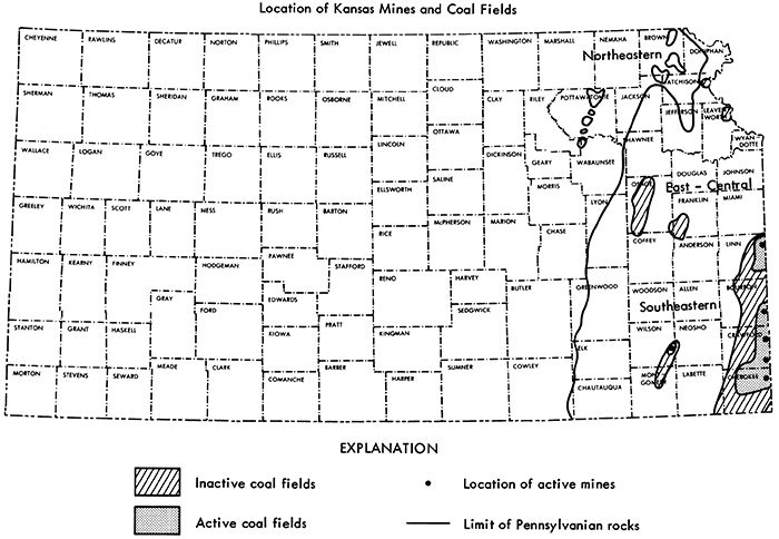
Coal reserves are located in 23 eastern Kansas counties with Cherokee, Crawford, and Linn counties in southeastern Kansas containing 66% of the demonstrated reserves. Future coal mining in Kansas will probably be concentrated in these three counties with additional mining in Bourbon and possibly Osage County. Small coal mines could operate in other counties having coal reserves such as the small coal mine in Wilson County. Presently, there are six coal mines operating in the state, two mines in Crawford County, two in Bourbon County, and one each in Wilson and Cherokee counties.
Four coals--the Mineral and Bevier coals of the Cherokee Groups, the Mulberry coal of the Marmaton Group, and the Nodaway coal of the Wabaunsee Group--represent 64% of the demonstrated coal reserves. Most coal production in Kansas in recent years has been from the Rowe, Mineral, Fleming, Croweburg, Bevier, and Mulberry coal beds. This trend differs significantly from the historical coal production in Kansas where nearly two-thirds of the coal mined was from the Weir-Pittsburg coal bed. With most of the strippable Weir-Pittsburg coal removed and a large part of the easily minable underground portion worked, a large portion of future coal production will probably be obtained from the Mineral, Bevier, and Mulberry coals. The Nodaway coal, with reserves mainly in Osage County, has provided nearly 12 million tons of coal in the past but future production could be hampered by a very high sulfur content.
Coal production in Kansas has gone through a major rise and subsequent decline since initial production over 115 years ago. Production peaked at slightly over seven million tons during 1917 and 1918 and declined to approximately 0.5 million tons during 1975. [For the conversion on English System measurements to Metric, see Appendix II.] The availability and use of petroleum and natural gas--cheap, clean, reliable sources of energy--in Kansas during the 1900's was the primary factor for the decline of coal. As reserves of these commodities decline, use of coal for energy purposes is again becoming important. Electric utilities are presently the major consumer of coal in Kansas and the U.s. (Zarley, 1975, p. 34; Westerstrom, 1975, p. 365) and will increase their coal consumption in the future (Dupree and Corsentino, 1975, p. 28).
Future production of Kansas coal will be tied to the exploitation of coal beds that were not the main source of past coal production. In the past, production was mainly from one bed with over 200 million tons of coal produced from the Weir-Pittsburg coal bed (estimate based on Abernathy, 1944, p. 221). Total coal production in Kansas through 1975 totaled approximately 300 million tons, with 50 million tons estimated to have been recovered by strip mining (Schoewe, 1958, p. 385, plus subsequent mine records).
Since 1964, strip mining has been the only mining method used in Kansas to recover coal. The principal coal beds mined in recent years are the Mineral, Mulberry, Croweburg, Fleming, Rowe, and Bevier coals, not the Weir-Pittsburg coal bed. In the future it is anticipated that strip mining will continue to be the main method of coal recovery. It is based on this assumption that this study was undertaken to evaluate the strippable coal reserves in Kansas.
The objective of this study was to determine the reserves of coals in Kansas that have a potential to be mined by surface methods. This includes the general distribution, coal thickness, amount of overburden, and general reliability class of the coal reserves. Only bituminous coals were evaluated; lignites of Cretaceous age in central Kansas were not covered in this report. A discussion of the Kansas lignites is presented by Schoewe (1952, 1958).
Although areas exist in several Kansas counties that have the potential for deep mining of coal, these areas were not included in this study. Reasons for this omission were the general lack of data on these deep coal areas, and the importance in the near future of the stripping coals in the state.
Two important characteristics about Kansas coal must be considered by anyone interested in mining or using Kansas coal:
All coal of economic importance in Kansas is of Middle Pennsylvanian or Late Pennsylvanian age. Most of the coals occur in the Cherokee Group; however, extensive reserves also exist for the Mulberry coal of the Marmaton Group and the Nodaway coal of the Wabaunsee Group. General distribution of coal in Kansas and the active coal mines in the state are shown in Figure 1.
Figure 1--Location of active Kansas coal mines and bituminous coal fields.
The first complete review of Kansas coal reserves and the one that forms the basic material for subsequent coal reserve investigations was by Abernathy, Jewett, and Schoewe (1947). In this 1947 study the proved coal reserves of Kansas were determined to be 949.323 million tons, and the potential coal reserves (resources) 17,574 million tons. Of these total reserves, 60 million tons were considered proven strippable coal reserves (p. 3). The basis of their reserve calculations were as follows:
(a) Minimum thickness of coal for proved strippable coal and all potential coal was 10 inches.
(b) Reserve coal was considered to be 125 tons per acre-inch of coal.
(c) Preparation and mining losses were not considered and reserve figures are coal in place.
(d) Maximum depth of strippable coal was 60 feet with an overburden to coal stripping ratio of 35 cubic yards of overburden to one ton of coal.
(e) Minimum thickness of reserve coal considered variable for mining by underground methods was as follows:
| Depth (ft.) | Min. Coal Thickness (inches) |
|---|---|
| 100 | 16 |
| 150 | 18 |
| 200 | 22 |
| 600 | 32 |
| 1200 | 36 |
(f) Proved coal reserves were determined as a known thickness of coal at a point location proving the same thickness of coal under one square mile. Two or more known coal occurrences of the same coal bed four or less miles apart were considered as proving the coal between the points. In calculating potential reserves, a known point thickness was considered to indicate coal of the same thickness under 400 square miles. The presence of thinner coal or erosion greatly reduced the different areas considered.
Schoewe (1958, p. 386-388) re-evaluated the Kansas coal reserves using similar criteria as the Abernathy et al. (1947) study for underground coal thickness. However, Schoewe used 1800 tons per acre-foot for coal and more closely defined his coal reliability to:
Stripping coal was considered by Schoewe as being at least 12 inches thick, less than 60 feet deep, and not exceeding 35 cubic yards of overburden per ton of coal. Total resources shown by Schoewe (1958, p. 388) are 1,919.344 million tons of measured and indicated coal; 16,787 million tons inferred coal, totaling 18,706.344 million tons. Schoewe (1958) did not give an estimate of stripping coal reserves.
Stripping coal reserves were evaluated for Kansas by Stroup and Falvey (1969). Criteria for determining strippable coal reserves were based by Stroup and Falvey at a minimum coal thickness of 12 inches and a stripping ratio of 20-25 cubic yards overburden to a ton of coal. Total strippable coal reserves estimated by Stroup and Falvey for Kansas are 215.2 million tons, with 830.9 million tons of reserves for both stripping and underground methods.
By allowing an overburden thickness of 100 feet, additional areas not considered by Stroup and Falvey, and a slightly larger stripping ratio, Averitt (1970) estimated the original Kansas stripping coal resources at 500 million tons. Allowing for past stripping, this would give a reserve of approximately 450 million tons.
The U.S. Bureau of Mines (1971, p. 83-84) estimates strippable reserves in Kansas to be 375,473,000 tons. This estimate is based on a 12 inch minimum thickness, 120 feet maximum overburden thickness, and stated (p. 12) economic stripping ratio of 15 feet overburden to one foot of coal.
In a summary report, the U.S. Bureau of Mines (1974) lists the "Demonstrated" amount of strippable coal at 1,388 million tons. This total is based on "Measured" and "Indicated" coals under 120 feet or less of overburden and a 14 inch minimum thickness of coal.
Based primarily on the estimate of Schoewe (1958) the total coal resources in Kansas are estimated by Averitt (1975) to be 22,668 million tons. This figure is determined primarily from Schoewe's (1958) estimate plus 4000 million tons estimated hypothetical resources (p. 14).
Many individuals were responsible for providing, compiling, measuring, and assembling the data used for this report. The following individuals and firms are especially recognized for their contribution to the study: U.S. Bureau of Mines and D.H. White, Jr., for providing funds to continue and complete this study after a slow initial effort; Pittsburg and Midway Coal Mining Company and the following employees of that company--J.A. Borders, H.E. Knight, T.C. Dewey, F.J. Foresman, B.M. Darnay, and Kenneth Cassidy--for providing considerable data and discussion on the Cherokee Group coals and the Mulberry coal; Clemens Coal Company with J.W. Mackie, Jr., D.E. Fleury, and H.C. Brown--employees and former employee--providing data on the Cherokee Group coals; Bill's Coal Company and W.D. Patch and Sam Shaw III of that company for additional data on Cherokee coals.
Numerous individuals presently or formerly associated with the Kansas Geologial Survey contributed a great deal to the assembling of data, initial reserve calculations, tabulation of data, and contributions to the development of the final report. Because of the abundant data and interconnection of different research and administrative services, a good part of the Survey provided aid and assistance on this study. Individuals who have contributed considerable time and effort to the study include: L.F. Dutcher, who initiated the study, W.W. Hambleton, Helen Wolfe, R.G. Hardy, J.M. Budai, Joann Laskowski, Jean Ashton, Vickie Bryant, G.D. Romero, M.A. Soule, G.A. Waldron, and D.L. Beene.
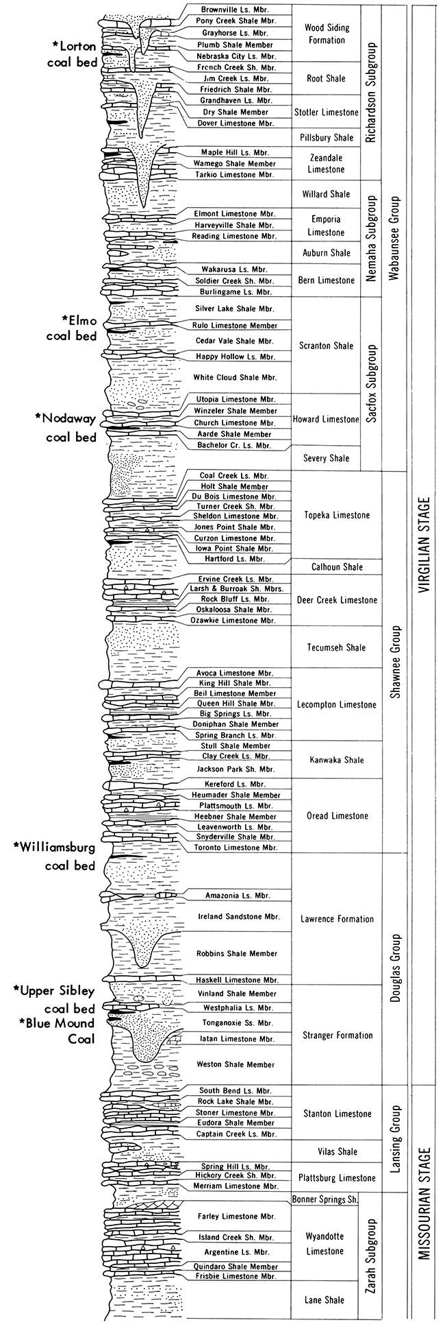
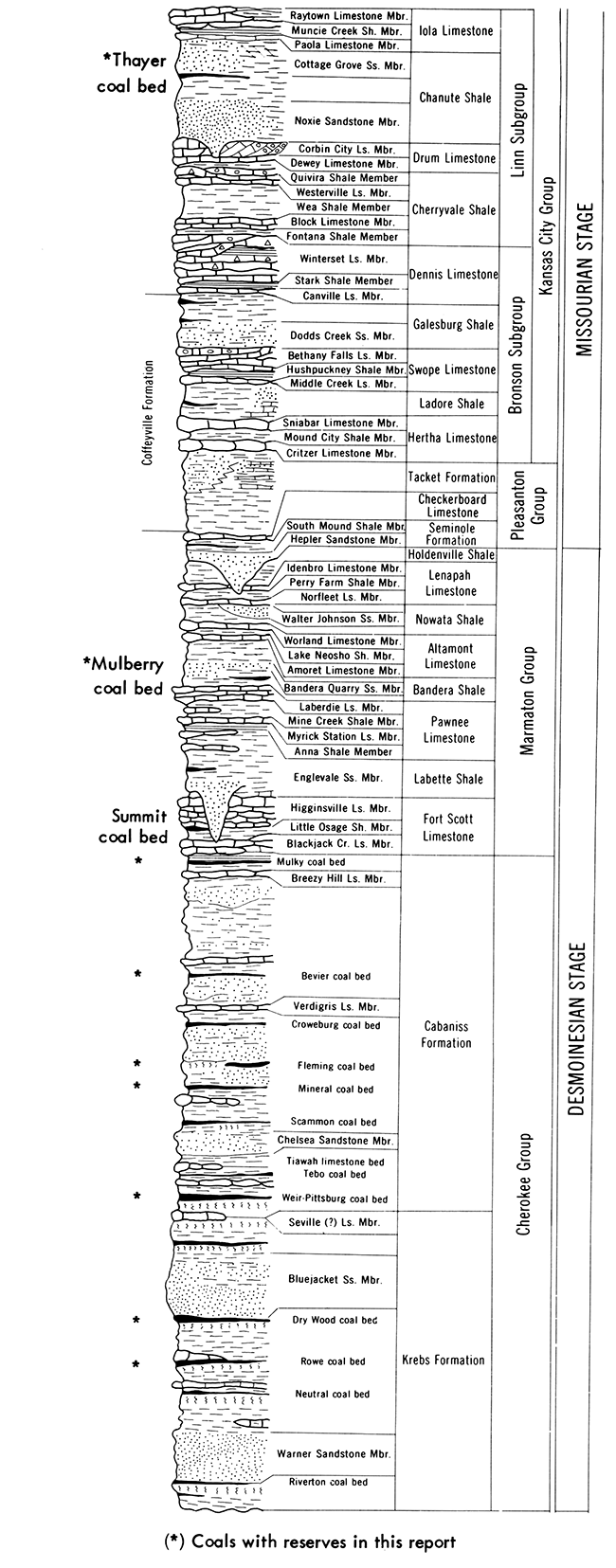
Coal beds considered for reserves in this report are all strippable or have the potential of being stripped. These coals and their stratigraphic position are shown in Figure 2. Only coals 12 inches or greater in thickness were considered in the reserve classification. Thickness of overburden for this study was limited to a maximum of 100 feet. In considering the economic potential for stripping of the coals in this report three categories were included: (a) coal having an overburden/coal thickness ratio of 30:1 or less; (b) coal with thickness of overburden ranging from 0-50 feet; and (c) coal with thickness of overburden ranging from 50 to 100 feet.
Figure 2--Stratigraphic distribution of bituminous coals having strippable coal reserves in Kansas (modified from Zeller, 1968).
The 30:1 stripping ratio considered in this report for coal in place would be the upper limit of an economic stripping ratio that would be considered at this time (1976). However, this could change drastically with improved mining equipment, techniques, or changes in coal value. In 1974 the Pittsburg and Midway Coal Mining Company was mining at approximately a 36:1 ratio (in this ratio, 36 cubic yards of overburden to one ton of saleable coal) in Cherokee County at Mine #19. For coal in place, the stripping ratio of 36:1 is approximately equal to a 30:1 ratio of thickness of overburden to thickness of coal.
Lithology of the overburden is also quite important in determining an economic stripping ratio. Important coals strip-mined in Kansas in the past principally have had shale overburden, but a number of the coals considered in this report have thick limestone units present a small distance above the coal (Fig. 2).
Three classes of reliability were included in this study based on categories agreed upon by the U.S. Bureau of Mines and the U.S. Geological Survey (see Averitt, 1975, p. 26-27). In summary, the three reliability classes used in this report are as follows:
Measured--Estimates of measured reserves are based on outcrops or borings showing coal 12 inches or greater in thickness where data points are one half mile or less in distance from each point. For single data points a radius of one quarter mile was considered for those areas where the coal bed is considered to be present based on structure and topography.
Indicated--Estimates of ,indicated reserves are based on outcrops or borings showing coal 12 inches or greater and at,a distance from one half to 1.5 miles between data points. For a single data point the radius distance from 0.25 to 0.75 mile from the data point where the coal is believed to exist was considered in the indicated category.
Inferred--Estimates included in the inferred category follow the same basic rules as the measured and indicated classes, except the distance between data points ranges from 1.5 to 6 miles. For individual data points the radius from the individual point for the inferred category would be from 0.75 to 3 miles from where the coal is considered to exist.
Demonstrated--This term implies the combined tonnage of the Measured and Indicated classes of coal reserves. This class of reserves is used by the U.S. Bureau of Mines (1974) to classify coal as reserves rather than resources.
Data utilized in the reserve study were derived from numerous sources including: (a) proprietary drill information from coal companies; (b) stratigraphic sections, mine maps, and well logs on file at the Kansas Geological Survey; (c) published reports; (d) field examinations; (e) discussions with coal company personnel; and (f) yearly publications titled, Report of the Inspector of Coal Mines, State of Kansas, covering a time period from 1891 to 1956.
Extensive data were obtained from the Pittsburg and Midway Coal Mining Company, covering Mineral, Fleming, Croweburg, Bevier, and Mulberry coals in large areas of Bourbon, Cherokee, Crawford, and Linn counties. Density of the data derived from the Pittsburg and Midway Company was close enough and covered a large enough area that isopach (thickness) maps were made for reserve determinations. Coal information was key punched and maps plotted by a Gerber 600 flatbed plotter, and processed on a Honeywell 635 computer. The maps were then analyzed to block out areas where there was a lack of data control. Reserve information was derived from the maps by planimeter measurements.
Maps were plotted for each coal bed and the reliability class determined as measured or indicated depending on the density of the data. Additional data outside the map areas were hand compiled with the data plotted on U.S. Geological Survey topographic maps, and reserve areas planimetered.
Over 3200 data points were used for the reserve determinations. Many of these data points represent borings that include multiple coal beds. Approximately 2600 data points were used for the computer mapping program and 620 data points for the reserves calculated from topographic maps. An estimated 2000 data points contain information on two or more coal beds having reserves of coal.
Of the 17 coal beds considered in this study to have economic potential, only portions of five coals were actually mapped by computer contour methods and reserves calculated based on the maps. The remaining coals were individually plotted on topographic maps and coal reserves calculated by planimeter methods. In all cases, all known data points were used except in a few areas having very close drilling data. Structure and topographic conditions were considered in the coal reserve calculations.
Only coal beds 12 inches or thicker were considered as reserves for this study. In any area where the individual coal bed was measured as less than 12 inches, its area of influence was not considered as reserves except as it affects adjacent reserve areas.
All reserve totals shown in the report are for coal reserves in place. Excluded from coal reserve considerations are areas of coal under towns, and Federal areas such as the Marais des Cygnes Wildlife Refuge, Melvern Reservoir area, and other areas unlikely to be mined. Included in the figures, however, were areas under federal, state, and county highways and roads and areas of rural housing development outside of the city limits.
All coal beds except the Weir-Pittsburg and the Mulberry coal, the two thickest coal beds in Kansas, were divided in thickness intervals of 0.25 feet and reserves calculated for these intervals. The Weir-Pittsburg and Mulberry coal beds were divided into 0.5 foot thickness intervals. All calculations were based on a coal weight of 1800 tons/acrefoot for coal in place. This tonnage figure correlates with values used in similar reserve reports (Friedman, 1974, p. 17; Robertson, 1971, p. 29; Averitt, 1975, p. 21).
The strippable bituminous coal reserves of Kansas contain 526 million tons of measured and indicated coal having a stripping ratio of 30 feet or less overburden to one foot of coal. In addition, there are 794 million tons of coal in the inferred reliability class having the 30:1 or less stripping ratio. These values for coal in place represent a figure based on the present economic limits of mining.
In addition to the 30:1 ratio reserve figure, reserves were also evaluated for coals under 50 feet or less of overburden and those having overburden thicknesses less than 100 feet. Evaluation of these reserves show a total of 998 million tons of measured and indicated coal reserves and 1,816 million tons of inferred coal reserves under 100 feet or less of overburden.
A summary of the tonnage of strippable Kansas coals by coal bed and county is tabulated in Table 1. This table shows that four coals - the Mineral, Bevier, Mulberry, and Nodaway coals - contain the major percentage of coal reserves in the state. These four coals represent 64 percent of the demonstrated coal reserves (measured and indicated) having a 30:1 stripping ratio, and 68 percent of the demonstrated reserves under less than 100 feet of overburden.
Table 1--Strippable Reserves of Kansas Coals by Coal Bed (millions of short tons)
| County | 30:1 Stripping Ratio | 0-50 ft. Overburden | 50-100 ft. Overburden | ||||||
|---|---|---|---|---|---|---|---|---|---|
| Measured | Indicated | Inferred | Measured | Indicated | Inferred | Measured | Indicated | Inferred | |
| Rowe Coal Bed | |||||||||
| Cherokee | 2.56 | 12.07 | 54.22 | 2.56 | 12.73 | 66.64 | 1.71 | ||
| Crawford | 1.27 | 3.47 | 12.86 | 1.27 | 3.47 | 13.26 | 1.31 | ||
| TOTAL | 3.83 | 15.54 | 67.08 | 3.83 | 16.20 | 79.90 | 3.02 | ||
| Dry Wood Coal Bed | |||||||||
| Cherokee | 0.81 | 4.34 | 18.12 | 0.77 | 4.88 | 21.59 | |||
| Crawford | 0.56 | 2.00 | 1.75 | 0.56 | 2.00 | 2.15 | 1.28 | ||
| TOTAL | 1.37 | 6.34 | 19.87 | 1.33 | 6.88 | 23.74 | 1.28 | ||
| Weir-Pittsburg Coal Bed | |||||||||
| Bourbon | 0.10 | ||||||||
| Cherokee | 9.81 | 31.90 | 43.35 | 8.97 | 34.13 | 19.52 | 19.95 | 5.51 | 34.59 |
| Crawford | 1.05 | 4.11 | 1.05 | 3.71 | 0.21 | 4.19 | 8.81 | ||
| TOTAL | 10.86 | 36.01 | 43.35 | 10.02 | 37.84 | 19.52 | 20.16 | 9.80 | 43.40 |
| Mineral Coal Bed | |||||||||
| Bourbon | 1.29 | 1.03 | 10.33 | 1.03 | 7.39 | 0.04 | 4.30 | ||
| Cherokee | 17.28 | 17.39 | 90.63 | 21.02 | 15.20 | 90.63 | 11.69 | 32.25 | 108.85 |
| Crawford | 34.91 | 6.68 | 41.05 | 42.14 | 6.81 | 41.73 | 28.02 | 32.48 | 41.18 |
| Labette | 0.64 | 0.64 | 20.47 | ||||||
| TOTAL | 53.48 | 25.74 | 131.68 | 73.49 | 23.68 | 132.36 | 47.10 | 64.77 | 174.80 |
| Fleming Coal Bed | |||||||||
| Bourbon | 1.81 | 2.48 | 6.13 | 0.12 | 0.46 | ||||
| Cherokee | 0.59 | 1.32 | 10.47 | 8.32 | 2.15 | 10.47 | 0.24 | 2.30 | |
| Crawford | 0.60 | 1.35 | 8.39 | 3.62 | 10.84 | 7.16 | 0.09 | 4.90 | 1.99 |
| TOTAL | 3.00 | 2.67 | 18.86 | 14.42 | 19.12 | 17.63 | 0.45 | 7.66 | 1.99 |
| Croweburg Coal Bed | |||||||||
| Bourbon | 2.21 | 3.55 | 0.99 | ||||||
| Cherokee | 6.24 | 4.40 | 32.43 | 7.56 | 4.65 | 34.36 | 0.08 | 0.89 | |
| Crawford | 0.36 | 12.54 | 21.80 | 1.71 | 21.85 | 26.29 | 0.09 | 3.64 | 10.09 |
| TOTAL | 6.60 | 19.15 | 54.23 | 9.27 | 30.05 | 60.65 | 0.17 | 5.52 | 10.09 |
| Bevier Coal Bed | |||||||||
| Bourbon | 0.14 | 8.53 | 4.61 | 0.20 | 13.04 | 6.74 | 15.21 | 9.88 | |
| Cherokee | 28.94 | 12.91 | 14.54 | 26.95 | 12.91 | 14.54 | 3.49 | 1.59 | 3.12 |
| Crawford | 2.54 | 24.69 | 40.43 | 8.87 | 29.65 | 43.78 | 9.15 | 35.58 | 35.52 |
| Labette | 8.23 | 8.30 | 2.40 | ||||||
| TOTAL | 31.62 | 54.36 | 59.58 | 36.02 | 63.90 | 65.06 | 12.64 | 54.78 | 48.52 |
| Mulky Coal Bed | |||||||||
| Bourbon | 3.22 | 9.24 | 38.39 | 3.62 | 9.35 | 47.77 | 0.32 | 2.16 | 27.69 |
| Crawford | 1.00 | 1.00 | 1.00 | 1.00 | 10.52 | 0.63 | |||
| TOTAL | 4.22 | 10.24 | 38.39 | 4.62 | 10.35 | 58.29 | 0.32 | 2.16 | 28.32 |
| Mulberry Coal Bed | |||||||||
| Bourbon | 16.39 | 16.15 | 0.37 | ||||||
| Linn | 30.55 | 67.05 | 140.98 | 14.05 | 35.92 | 104.69 | 45.37 | 101.43 | 89.61 |
| Miami | 4.58 | 7.00 | |||||||
| TOTAL | 30.55 | 67.05 | 161.95 | 14.05 | 35.92 | 120.84 | 45.37 | 101.43 | 96.98 |
| Thayer Coal Bed | |||||||||
| Montgomery | 0.87 | 3.93 | 9.08 | 0.87 | 3.93 | 12.35 | 0.05 | 1.81 | 10.83 |
| Neosho | 0.23 | 0.90 | 2.93 | 0.23 | 0.86 | 4.85 | 0.30 | 20.53 | |
| Wilson | 0.43 | 1.30 | 4.00 | 0.59 | 2.15 | 4.47 | 0.01 | 0.05 | 0.61 |
| TOTAL | 1.53 | 6.13 | 16.01 | 1.69 | 6.94 | 21.67 | 0.06 | 2.16 | 31.97 |
| Blue Mound Coal Bed | |||||||||
| Douglas | 0.53 | 0.78 | 1.82 | 0.64 | 1.05 | 2.44 | 0.23 | 1.61 | 1.41 |
| TOTAL | 0.53 | 0.78 | 1.82 | 0.64 | 1.05 | 2.44 | 0.23 | 1.61 | 1.41 |
| Sibley Coal Bed | |||||||||
| Brown | 0.67 | 1.59 | 7.53 | ||||||
| Leavenworth | 3.40 | 8.76 | 20.62 | 4.62 | 8.76 | 29.74 | 0.11 | 3.69 | 24.76 |
| TOTAL | 3.40 | 8.76 | 21.29 | 4.62 | 8.76 | 31.33 | 0.11 | 3.69 | 32.29 |
| Lower Williamsburg Coal Bed | |||||||||
| Douglas | 0.42 | 1.75 | 14.82 | 0.42 | 1.75 | 19.96 | 0.17 | 1.48 | 27.96 |
| Franklin | 0.21 | 0.38 | 1.37 | 0.21 | 0.38 | 1.47 | 0.03 | 0.00 | |
| TOTAL | 0.63 | 2.13 | 16.19 | 0.63 | 2.13 | 21.43 | 0.20 | 1.48 | 27.96 |
| Upper Williamsburg Coal Bed | |||||||||
| Anderson | 0.59 | 3.31 | 0.68 | 0.59 | 3.31 | 0.81 | 0.21 | 0.71 | |
| Franklin | 5.68 | 12.31 | 8.04 | 5.87 | 12.64 | 11.80 | 6.54 | 6.13 | 25.72 |
| Osage | 1.47 | 3.76 | 0.09 | 1.47 | 3.76 | 0.36 | 1.74 | ||
| TOTAL | 7.74 | 19.38 | 8.81 | 7.93 | 19.71 | 12.97 | 6.75 | 6.84 | 27.46 |
| Nodaway Coal Bed | |||||||||
| Atchison | 0.57 | 2.08 | 2.96 | 0.99 | 2.08 | 5.35 | 0.32 | 1.38 | 14.85 |
| Chautauqua | 0.44 | 2.80 | 3.53 | 0.53 | 2.95 | 4.69 | 0.14 | 1.49 | 34.34 |
| Coffey | 0.71 | 3.34 | 7.35 | 0.71 | 3.34 | 10.77 | 10.95 | ||
| Cowley | 0.64 | 2.04 | 10.84 | 0.64 | 2.04 | 13.82 | 0.16 | 1.04 | 22.35 |
| Doniphan | 0.12 | 0.69 | 2.05 | 0.16 | 1.33 | 6.89 | 0.01 | 1.13 | 15.00 |
| Elk | 0.19 | 0.41 | 11.20 | ||||||
| Franklin | 0.24 | 1.68 | 7.88 | 0.24 | 1.68 | 14.52 | 17.95 | ||
| Jefferson | 0.60 | 2.87 | 3.81 | 0.60 | 2.87 | 5.62 | 0.03 | 0.96 | 10.22 |
| Lyon | 0.09 | 0.48 | 0.29 | 0.09 | 0.71 | 0.72 | 3.86 | ||
| Osage | 10.12 | 33.94 | 35.75 | 12.27 | 46.84 | 46.34 | 0.62 | 8.62 | 103.01 |
| Shawnee | 1.51 | 8.83 | 13.22 | 1.51 | 8.83 | 17.75 | 1.28 | 0.44 | 18.98 |
| TOTAL | 15.04 | 58.75 | 87.87 | 17.74 | 72.67 | 126.88 | 2.56 | 15.06 | 262.71 |
| Elmo Coal Bed | |||||||||
| Atchison | 0.94 | 2.65 | 0.61 | 1.86 | 5.06 | 1.29 | 0.11 | 0.95 | 10.48 |
| Brown | 1.19 | 5.24 | 19.12 | 1.61 | 5.02 | 36.30 | 0.31 | 2.89 | 66.93 |
| Doniphan | 3.78 | 5.35 | 6.66 | ||||||
| Jackson | 0.12 | 0.53 | 2.64 | 0.25 | 0.99 | 6.17 | 0.09 | 0.37 | 12.69 |
| Jefferson | 2.46 | 4.85 | 12.50 | ||||||
| Shawnee | 1.35 | 5.54 | 16.10 | 1.35 | 6.19 | 21.69 | 0.29 | 0.94 | 37.63 |
| TOTAL | 3.60 | 13.96 | 44.71 | 5.07 | 17.26 | 75.65 | 0.80 | 5.15 | 146.89 |
| Lorton Coal Bed | |||||||||
| Brown | 0.09 | 1.26 | 2.76 | 0.09 | 1.26 | 5.81 | 0.33 | ||
| TOTAL | 0.09 | 1.26 | 2.76 | 0.09 | 1.26 | 5.8l | 0.33 | ||
| TOTAL | 178.09 | 348.25 | 794.45 | 205.46 | 373.72 | 876.17 | 136.92 | 282.11 | 939.42 |
In Appendix I, Table 2 shows the distribution of strippable coal reserves by county, coal bed, and coal thickness.
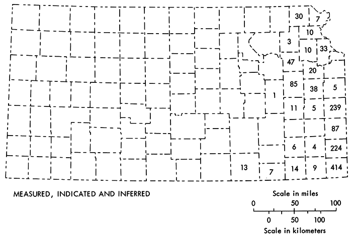
Basically, Table 2 shows that 23 counties in eastern Kansas have demonstrated stripping coal reserves and 25 counties have inferred coal reserves. The three counties having the largest reserve amounts are Cherokee, Crawford, and Linn which comprise 66 percent of demonstrated reserves at a 30:1 ratio and 70 percent under 100 feet or less of overburden. Summaries of these tonnages of coal reserves by county are shown in Figures 3 and 4.
Figure 3--Distribution of bituminous coals by county in millions of short tons for coals having a stripping ratio of 30:1 or less.
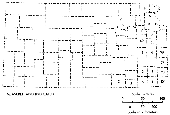
Figure 4--Distribution of bituminous coals by county in millions of short tons for coals having an overburden of 100 feet or less.
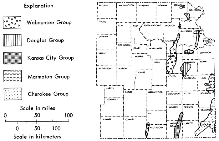
Distribution of the coal reserves by geologic groups (Fig. 2) in eastern Kansas is shown in Figure 5. A summary of Kansas coals by geologic group shows that the Cherokee Group of coals are the most important coal beds in the state. This group contains the important coal beds mined in the past and represents nearly 92 percent of the past production. The Cherokee coals will continue to be an important factor in Kansas coal production, but the largest production in the near future will probably come from the Mulberry coal of the Marmaton Group. Distribution of the strippable coal reserves by the various geological groups is shown by the following tonnages:
| Group | 30:1 Ratio | 100 ft. Overburden or Less | ||
|---|---|---|---|---|
| Demonstrated | Inferred | Demonstrated | Inferred | |
| Cherokee | 285 | 433 | 587 | 769 |
| Marmaton | 98 | 162 | 197 | 218 |
| Kansas City | 8 | 16 | 11 | 54 |
| Douglas | 43 | 43 | 66 | 157 |
| Wabaunsee | 93 | 135 | 138 | 618 |
Figure 5--General distribution of strippable coal reserves by geologic group for coals under 100 feet of overburden or less.
The Rowe coal bed is presently mined in southeast Crawford County and northeast Cherokee County. An additional large coal mine primarily mining the Rowe coal exists just across the Kansas line in Barton County, Missouri. Areas of Rowe coal reserves are located near these mining areas with coals generally 12 to 20 inches thick. In the Crawford County and Barton County, Missouri mining operations, the overlying Dry Wood coal is mined with the Rowe coal where sufficient thickness exists. In many locations there is a thin clay parting present in the coal. The Rowe coal is described by Pierce and Courtier (1938, p. 65), and further defined by Howe (1956, p. 37).
There has been limited production from the Rowe coal in the past, but within the last ten years it has become one of the important coals being mined in Kansas. There are potentially greater reserves of Rowe coal present in Cherokee and Crawford counties than appear in Tables 1 and 2.
The Dry Wood coal is mined as the upper seam of a two-seam mining operation with the Rowe coal. Variable in quality and thickness within rather short distances, the Dry Wood coal ranges up to 18 inches in thickness but is typically 12-14 inches thick where mined. Reserves are limited to southeastern Crawford and northeastern Cherokee counties. Presently the Dry Wood coal is mined in southeast Crawford County, and just across the state line in Barton County, Missouri. The stratigraphic relations of the Dry Wood coal at several localities are described by Howe (1956) and Brady (1976).
Extensive mining of the Weir-Pittsburg coal in the past has resulted in removal of most of the coal reserves of this bed. Both undergound and surface mining methods have resulted in production of over 200 million tons of this coal. Remaining reserves calculated in this report are small amounts of coal located along the margins and isolated areas of some of these old mines in Cherokee and Crawford counties. There are no coal mines presently mining the Weir-Pittsburg coal bed in Kansas. Thickness of the coal ranges up to four feet, but where mined in the past it was typically 36 to 38 inches in thickness. Generally the greater thickness of coal is in the southern part of its mined area.
Discussion of the Weir-Pittsburg coal and its relation to other units of the Cherokee Group is covered in Howe (1956, p. 46-48) and Pierce and Courtier (1938). Distribution and geologic structure of the Weir-Pittsburg coal are shown in Pierce and Courtier (1938, Plate 5). Distribution of the mined areas of the coal are shown by Abernathy (1944, 1946).
In recent years the Mineral coal has been the most important coal bed for total tonnage of coal produced in Kansas. Presently, one coal mine in northern Crawford County is producing from the Mineral coal bed. Another mine in southeastern Bourbon County has recently produced a small amount of coal from the Mineral coal bed.
A large mine operated in northwest Cherokee County until 1974 mined the Mineral coal (along with a higher second seam where economically feasible). Reserves of the coal are located primarily in Cherokee and Crawford counties, with a lesser amount in Bourbon County. Thickness of the Mineral coal where mined is typically 16 to-22 inches. In general, the Mineral is a high Btu coal that has been extensively mined in the past by surface mining methods.
General distribution of the mined areas are shown by Abernathy (1946), with more recent mining in northwestern Cherokee County shown by Camin and Hardy (1972, Plate 1). Stratigraphic relations of the Mineral coal bed are listed in Pierce and Courtier (1938, p. 69-73) and Howe (1956, p. 60-62). A petrographic study of the coal was made by Hambleton (1953). Measured section relations are shown in Howe (1956) and Brady (1976).
Variability in thickness and quality are typical of the Fleming coal throughout the area where mined. In recent years the Fleming coal has been mined as a second coal bed where economically feasible. It is presently mined in southeast Bourbon County along with the Croweburg coal bed. Where possible, the Fleming was commonly mined with the Mineral coal in the large mining operation of northwest Cherokee County. Where mined, the coal is typically 12-15 inches in thickness. The rapid thickness change in the coal is described by Howe (1956, p. 28) as commonly ranging from a streak to a coal bed over one foot in thickness within a few hundred yards.
Descriptions of the Fleming coal and its stratigraphic relations are given in Pierce and Courtier (1938, p. 73-74) and Howe (1956, p. 66-68).
Distribution of the Croweburg coal reserves are primarily in northwestern Cherokee, northeastern Crawford, and southeastern Bourbon counties. At the present time, the Croweburg coal is mined with the Fleming coal in Bourbon County and with the Mineral coal in Crawford County. Where feasible, the Croweburg was mined with the Mineral coal in northwestern Cherokee County. Thickness of the Croweburg coal is typically less than 15 inches but local areas of greater thickness are present. This coal has a very wide distribution outside of Kansas. Wanless, Baroffio, and Trescott (1969, p. 131) consider the coal swamp that resulted in the Croweburg coal, and its equivalent to the east, the Colchester coal, as possibly representing the most extensive coal swamp that ever existed. This swamp extended from central Oklahoma to eastern Pennsylvania, and from western Iowa to central West Virginia.
Areas of Croweburg coal in Kansas that were previously strip-mined are shown by Abernathy (1946). Stratigraphic relations of the Croweburg coal with other Cherokee Group units are described by Howe (1956, p. 68-72), and Pierce and Courtier (1958, p. 74-76). Physical and chemical properties of the Croweburg are described by Hambleton (1953).
Past production and presently calculated reserves make this coal one of the five important coal beds in Kansas. It has been mined extensively along its crop line from southwestern Labette County across northwestern Cherokee and Crawford counties to southeastern Bourbon County (Abernathy, 1946). There is no production of the Bevier coal at the present time in Kansas; however, the Bevier has been mined in both Cherokee and Crawford counties within the last five years. The Bevier coal lies just above the Verdigris Limestone, and has a typical thickness of 14 to 18 inches.
As with previous Cherokee Group coals, the stratigraphic relations of the Bevier coal are discussed by Pierce and Courtier (1938, p. 76-77) and Howe (1956, p. 78-80). An extensive petrographic study was made of the Bevier coal by Hambleton (1953).
The uppermost coal bed in the Cherokee Group is the Mulky coal. This coal has reserves in northeastern Crawford County and eastern Bourbon County, with a large amount of the reserves in the 12-15 inch thickness range. Thicker reserves are more common northward in Bourbon County than in Crawford County. In general, the Mulky coal lies 32-60 inches below the Blackjack Creek Limestone member of the Fort Scott Limestone (Schoewe, 1959, p. 207).
Overburden consists of the Excello Shale of the Cabaniss Formation, the Blackjack Creek Limestone (3.5 to 17.5 feet thick), Little Osage Shale (4 to 12 feet thick) and the Higgensville Limestone (15 feet thick) of the Fort Scott Limestone Formation (Schoewe, 1959). This extensive limestone overburden has limited the amount of stripping of the Mulky coal, and resulted in contour stripping rather than the area stripping method that is commonly used for the other coals of the Cherokee Group. At the present time, there is no mining of Mulky coal; however, there has been about 3.6 million tons mined in the past by stripping and small drift mines (Schoewe, 1959, p. 215-216).
Stratigraphic relations of the Mulky coal, its distribution, mined areas, and potential are discussed by Schoewe (1959). Other authors describing the Mulky relative to the Cherokee Group coals and rock units are Howe (1956, p. 84-89) and Pierce and Courtier (1938, p. 78-79) who refer to the Mulky as the Fort Scott coal bed.
Reserves of the Mulberry coal make up one of the most important coals for stripping in Kansas. The reserves are primarily in eastern Linn County, with lesser amounts in northeastern Bourbon County. A small amount of inferred reserves are also present in southeastern Miami County. Total past production of Mulberry coal is approximately 11 million tons, with all but about 20 to 30 thousand tons mined in Linn County.
At the present time no Mulberry coal is being mined in Kansas, but extensive mining of the coal is presently being conducted just across the state line in Bates County, Missouri. It is expected that there will be extensive mining of the Mulberry coal in Linn County, Kansas in the near future. Of coals having extensive strippable reserves in KansaS, the Mulberry coal has the greatest thickness, averaging slightly more than two feet, but ranges in thickness up to four feet.
A summary of the Mulberry coal, its stratigraphy, characteristics, production, and mining methods, is provided by Schoewe (1955). Additional discussion of the Mulberry coal and its mining is discussed by Whitla (1940, p. 17-18, 30-31, 46-51).
Within the Kansas City Group, the Thayer coal bed of the Chanute Shale is the only coal of economic importance. The Thayer coal is present along the crop line of the Chanute Shale from Kansas City southward through Montgomery County (Schoewe, 1944). Thickness of the Thayer coal sufficient to be classified as reserves is present only in Neosho, Wilson, and Montgomery counties.
One mine is presently mining the Thayer coal in eastern Wilson County. Based on Schoewe (1944, p. 103-106) and recent coal production, the total coal mined from the Thayer coal bed is estimated at 800,000 tons. The present mining operation is a strip mine, but mining in the past was drift or slope mines into the side of a hill, commonly operated by one person. In addition to the drift mines there were several small strip and shaft mines used to mine the Thayer coal (Schoewe, 1944, p. 99-103). Additional information on mining of the Thayer coal is provided by Whitla (1940).
Reserves for the Thayer coal were determined in a slightly different manner than the other coals. A persistent shale parting of variable thickness occurs where the coal is the thickest. This parting is normally two to three inches thick, but attains a thickness up to seven inches. Because of mining problems that are associated with removal of the shale within the coal, a three inch thickness of coal was subtracted from the total coal thickness at a given location. Reserves listed in Table 2 are actually three inches thicker at the measured location. Most thickness data used in preparing the reserve figures were derived from Schoewe (1944).
Occurrence of reserves in the Blue Mound coal bed is limited to eastern Douglas County. Extensive mining of this coal occurred east of Lawrence in the late 1800's with the coal used for firing locomotives on the Santa Fe Railroad (Bowsher and Jewett, 1943, p. 39-40). There was later mining of the coal in the area but no production records are known.
The Sibley coal extends from Franklin through Douglas to Leavenworth counties, but only Leavenworth County has any significant reserves. Actually there are two Sibley coals in Leavenworth County, an Upper Sibley coal and a Lower Sibley coal, but only the Upper Sibley coal had sufficient thickness for reserve calculations. Numerous small shaft and drift mines have operated in Leavenworth County in the past. Total coal production from the Sibley coal is unknown but it is believed to be on the order of five to eight thousand tons. Variable in thickness, the Sibley coal does range up to 25 inches in thickness, but is usually less than 18 inches. Some old analyses of the Sibley coal indicate a high ash content (Bowsher and Jewett, 1943, p. 47).
Recent population growth and potential poor quality of the coal in some areas could limit future mine development of the coal.
This coal, having reserve thickness, occurs in northwestern Franklin and western Douglas counties. Mining of the coal has been limited in the past to a few small shaft and drift mines. Of rather limited exposure and extent, there is little known about this coal. It is generally thin and believed to be of poor quality with ash value near 20 percent (Bowsher and Jewett, 1943, p. 54). Potential reserves were included in the reserve tables but based on the work of Bowsher and Jewett (1943) it is questionable if the coal will be further mined in the forseeable future.
Reserves of the Upper Williamsburg coal are present primarily in western Franklin, eastern Osage, and northwestern Anderson counties. Mining in the past was mainly in Franklin County and Osage County by various methods including shaft, drift, and strip mining; with total production approximately 90 thousand tons (Bowsher and Jewett, 1943).
One outstanding characteristic is the much lower sulfur content of the coal (one to two percent) when compared with other Kansas coals (Bowsher and Jewett, 1943, p. 56-57). In general, the reserves are thin with most reserves in the 12 to 15 inch category. The thickest deposits are in the Williamsburg vicinity. Occurring near the top of the Lawrence Formation, the Upper Williamsburg coal lies from nine to 30 feet below the Toronto Limestone member of the Oread Limestone Formation. The problem of removing the Toronto Limestone to obtain a thin coal bed could hinder development of this potentially important coal.
Stratigraphy, coal characteristics, and general mining history are covered by Bowsher and Jewett (1943) with limited discussion by Whitla (1940).
The Nodaway coal of Howard Limestone Formation is present in outcrop across Kansas in a north-south direction from Chautauqua to Doniphan counties. Reserves of the Nodaway coal are present in eleven counties with Osage County containing most of the reserves. Nearly 12 million tons of Nodaway coal have been produced in the past by underground and strip-mining methods with over 97 percent from Osage County (Schoewe, 1946, p. 50). Coffey County was the only other county having significant production with 200,000 tons.
Most of the Nodaway coal reserves are in the 15 to 18 inch thickness class, but Schoewe (1946, p. 24) describes some local thickening up to 36 inches.
The main problem associated with development of the Nodaway coal in the present coal market is the very high sulfur content (six to eight percent). Ash content is generally less than 10 percent and the coal generally runs over 11,000 Btu on an as-received basis (Schoewe, 1946, p. 30-31).
Overburden consists of shales and thin limestones of the Howard Limestone Formation. However, in some locations limestone comprising the Utopia Limestone Member can reach thicknesses of ten feet or more.
Better quantity and thickness of coal reserves and general good heating quality of the coal in Osage County make this area the most likely for coal mine development in the future. Production in Shawnee County which also has good quantities of Nodaway coal reserves is hindered by suburban development, zoning, and generally thinner coal thickness.
A good summary of the Nodaway coal is present in Schoewe (1946) and Whitla (1940). Stratigraphy and characteristics of the Nodaway coal in Osage County are discussed by O'Connor et al. (1955, p. 24).
The Elmo coal is similar to the Nodaway coal in north-south distribution across Kansas. Thicknesses of the Elmo coal that are sufficient to classify as reserves are limited to six counties in the northeastern part of Kansas. Shawnee and Brown counties, however, contain most of the reserves.
Thickness of the Elmo coal where classified as a reserve generally ranges from 12 to 16 inches with maximum thickness of 21 inches. Quality and physical characteristics of the Elmo coal are described by Schoewe (1946, p. 47) as being similar to the Nodaway coal, except that in some areas the Elmo coal has a one to two inch clay seam present. Overburden consists mainly of shales containing a few thin limestones.
Production of the Elmo coal was generally for local consumption, with a cumulative production of slightly over 200 thousand tons estimated by Schoewe (1946, p. 48).
Mining areas and thickness of the Elmo coal are described by Schoewe (1946) and Whitla (1940).
Brown County is the only area having sufficient thickness of Lorton coal to be classified as a reserve. Thickness of the Lorton is commonly less than 12 inches, but reaches 14 inches in northwestern Brown County. Overburden consists of shale with a few thin limestones.
Restriction in amount of reserves and lack of data on coal quality make potential development of this coal unlikely in the near future. The Lorton coal and its stratigraphic relations are given by Schoewe (1946, p. 67-68).
In addition to the 17 coals with reserve evaluations considered in this report, two additional coals and possibly one other coal have reserve potential. These coals are the Riverton coal of the Cherokee Group, the Summit coal of the Marmaton Group, and the Lower Sibley coal of the Douglas Group.
A small amount of Riverton coal was mined in the past and thickness of the coal ranges up to slightly more than 12 inches in southeastern Cherokee County (Howe, 1956, p. 31-32). Mining of the Summit coal is reported by Whitla (1940, p. 16, 29-30) as having been conducted in eastern Bourbon County on beds ranging up to two feet in thickness. This thickness and mining activity is questioned by Schoewe (1959, p. 196) who believed there was a mis-correlation and the coal mined was actually the Mulky coal. Both coals have a thick limestone unit a short distance above the coal and there is only a small stratigraphic interval between the coals. Schoewe (1959, p. 196) considered the Summit coal as being less than six inches in thickness and finds no evidence of it being mined in Kansas.
The Lower Sibley coal reaches a maximum thickness in south-central Leavenworth County of 13 inches at one known location (Bowsher and Jewett, 1943, p. 42-44). Only very small amounts of the Lower Sibley coal have been mined.
1. Evaluation of the stripping coal reserves in Kansas based on all available basic data of borings, measured sections, coal thickness at old and new mine areas show the following tonnage:
| 30:1 Stripping Ratio (overburden: coal) | |
|---|---|
| Measured | 178 million tons |
| Indicated | 348 million tons |
| Inferred | 794 million tons |
| 100 Ft. or Less of Overburden | |
| Measured | 342 million tons |
| Indicated | 656 million tons |
| Inferred | 1,816 million tons |
2. Distribution of the stripping coal reserves among the various geologic groups show that the Cherokee Group coals are by far the most important. Next in importance is the Marmaton Group represented by the Mulberry coal, and the Wabaunsee Group coals. Coal of the Douglas and Kansas City Group are of minor importance in the total Kansas reserve picture.
3. Among the 17 coal beds evaluated for stripping coal reserves in Kansas, four coals--the Mineral, Bevier, Mulberry, and Nodaway--contain the bulk of the reserves. For a 30:1 stripping ratio of demonstrated reserves, 64 percent of the coal is present in these four seams, and 68 percent of the coal reserves under less than 100 feet overburden comes from these reserves.
4. There are 23 counties in eastern Kansas that have bituminous coal reserves in the measured or indicated reliability classes and 25 counties having coal reserves in the inferred class. Of the 23 counties having demonstrated coal reserves, three counties--Cherokee, Crawford and Linn--comprise 66 percent of the 30:1 stripping ratio reserves and 70 percent of the coal under 100 feet or less of overburden.
Abernathy, G.E., 1944, Mined areas of the Weir-Pittsburg coal bed: Kansas Geol. Survey, Bull. 52, pt. 5, p. 213-228. [available online]
Abernathy, G.E., 1946, Strip-mined areas in the southeastern Kansas coal field: Kansas Geol. Survey, Bull. 64, pt. 4, p. 124-144.
Abernathy, G.E., Jewett, J.M., and Schoewe, W.H., 1947, Coal reserves in Kansas: Kansas Geol. Survey, Bull. 70, pt. 1, 20 p. [available online]
Averitt, Paul, 1970, Stripping coal resources of the United States, January 1, 1970: U.S. Geol. Survey, Bull. 1252-C, 20 p. [available online]
Averitt, Paul, 1975, Coal resources of the United States--January 1, 1974: U.S. Geol. Survey, Bull. 1412, 131 p. [available online]
Bowsher, A.L. and Jewett, J.M., 1943, Coal resources of the Douglas Group in east-central Kansas: Kansas Geol. Survey, Bull. 46, 94 p. [available online]
Brady, L.L., 1976, Coal and coal production in southeastern Kansas; in, Coal and oil potential of the Tri-State area: Tulsa Geological Society Field Trip Guidebook (April 30-May 1, 1976) p. 33-40.
Camin, K.Q. and Hardy, R.G., 1972, Mined-land redevelopment: Southeast Kansas portion of the Ozarks Region: Final report of the Mineral Resources Task Group (1971-72) to the Ozarks Regional Commission: Kansas Geol. Survey, Lawrence, Kansas, 173 p.
Dupree, W.G., Jr. and Corsentino, J.S., 1975, United States energy through the year 2000 (revised): U.S. Bureau of Mines, 65 p.
Friedman, S.A., 1974, An investigation of the coal reserves in the Ozarks section of Oklahoma and their potential uses: Final report to the Ozarks Regional Commission, July 10, 1974: Oklahoma Geol. Survey, 117 p.
Hambleton, W.W., 1953, Petrographic study of southeastern Kansas coals: Kansas Geol. Survey, Bull. 102, pt. 1, 76 p. [available online]
Howe, W.B., 1956, Stratigraphy, of pre-Marmaton Desmoinesian (Cherokee) rocks in southeastern Kansas: Kansas Geol. Survey, Bull. 123, 132 p. [available online]
Kansas Labor Department, 1891-1956, Report of the inspector of coal mines, State of Kansas (49 annual and biannual reports): Kansas Labor Dept., Topeka.
O'Connor, H.G., Goebel, E.D., Schoewe, W.H., and Plummer, Norman, 1955, Geology, mineral resources, and ground-water resources of Osage County, Kansas: Kansas Geol. Survey, Vol. 13, 50 p. [available online]
Pierce, W.G. and Courtier, W.H., 1938, Geology and coal resources of the southeastern Kansas coal field: Kansas Geol. Survey, Bull. 24, 122 p. [available online]
Robertson, C.E., 1971, Evaluation of Missouri's coal resources: Missouri Geol. Survey and Water Resources Rept. Inv. 48, 92 p.
Schoewe, W.H., 1944, Coal resources of the Kansas City Group, Thayer bed; in eastern Kansas: Kansas Geol. Survey, Bull. 52, pt. 3, p. 81-135. [available online]
Schoewe, W.H., 1946, Coal resources of the Wabaunsee Group in eastern Kansas: Kansas Geol. Survey, Bull. 63, 144 p. [available online]
Schoewe, W.H., 1952, Coal resources of the Cretaceous System (Dakota Formation) in central Kansas: Kansas Geol. Survey, Bull. 96, pt. 2, p. 69-156. [available online]
Schoewe, W.H., 1955, Coal resources of the Marmaton Group in eastern Kansas: Kansas Geol. Survey, Bull. 114, pt. 2, 112 p. [available online]
Schoewe, W.H., 1958, The geography of Kansas: pt. IV, Economic geography: mineral resources: Trans. Kansas Acad. Sci., v. 61, p. 367-391.
Schoewe, W.H., 1959, Coal resources of the Cherokee Group in eastern Kansas--1. Mulky coal: Kansas Geol. Survey, Bull. 134, pt. 5, p. 181-222. [available online]
Stroup, R.K. and Falvey, A.E., 1969, Coal reserves for steam-electric generation in Kansas and Missouri areas of Missouri River Basin: U.S. BuMines Prelim. Rept. 174, 37 p.
U.S. Bureau of Mines, 1971, Strippable reserves of bituminous coal and lignite in the United States: U.S. BuMines Inf. Circ. 8531, 148 p.
U.S. Bureau of Mines, 1974, Demonstrated coal reserve base of the United States on January 1, 1974: U.S. BuMines Mineral Industry Surveys, 6 p.
Wanless, H.R., Baroffio, J.R. and Trescott, P.C., 1969, Conditions of deposition of Pennsylvanian coal beds: Geol. Soc. America Special Paper 114, p. 105-142.
Westerstrom, L., 1975, Coal--bituminous and lignite: U.S. BuMines Yearbook 1973-Vol. I, p. 317-376.
Whitla, R.E., 1940, Coal resources of Kansas: Post-Cherokee deposits: Kansas Geol. Survey, Bull. 32, 64 p. [available online]
Zarley, Carol, 1975, Kansas energy balance 1974--Preliminary: Kansas Geol. Survey, Min. Resources Series no. 3, p. 34-36.
Zeller, D.E., (ed.), 1968, The stratigraphic succession in Kansas: Kansas Geol. Survey, Bull. 189, 81 p. [available online]
Table 2--Kansas Strippable Coal Reserves by County (millions of short tons)
| Coal | Thickness | 30:1 Stripping Ratio | 0-50 ft. Overburden | 50-100 ft. Overburden | ||||||
|---|---|---|---|---|---|---|---|---|---|---|
| Measured | Indicated | Inferred | Measured | Indicated | Inferred | Measured | Indicated | Inferred | ||
| Anderson | ||||||||||
| Upper Williamsburg |
1.0-1.25 | 0.59 | 3.31 | 0.68 | 0.59 | 3.31 | 0,81 | 0.21 | 0.71 | |
| Total | 0.50 | 3.31 | 0.68 | 0.59 | 3.31 | 0.81 | 0.21 | 0.71 | ||
| Atchison | ||||||||||
| Nodaway | 1.0-1.25 | 0.57 | 2.08 | 2.60 | 0.99 | 2.08 | 4.84 | 0.32 | 1.38 | 14.53 |
| 1.25-1.5 | 0.36 | 0.51 | 0.32 | |||||||
| Elmo | 1.0-1.25 | 0.94 | 2.65 | 0.61 | 1.86 | 5.06 | 1.29 | 0.11 | 0.95 | 10.48 |
| Total | 1.51 | 4.73 | 3.57 | 2.85 | 7.14 | 6.64 | 0.43 | 2.33 | 25.33 | |
| Bourbon | ||||||||||
| Weir-Pittsburg | 1.0-1.5 | 0.06 | ||||||||
| 1.5-2.0 | 0.04 | |||||||||
| Mineral | 1.0-1.25 | 0.81 | 0.78 | 7.26 | 0.78 | 3.76 | 0.33 | |||
| 1.25-1.5 | 0.48 | 0.25 | 2.61 | 0.25 | 1.88 | 0.04 | 3.97 | |||
| 1.5-1.75 | 0.45 | 0.56 | ||||||||
| 1.75-2.0 | 0.01 | 0.43 | ||||||||
| 2.0-2.25 | 0.42 | |||||||||
| 2.25-2.5 | 0.23 | |||||||||
| 2.5-2.75 | 0.11 | |||||||||
| Fleming | 1.0-1.25 | 1.81 | 2.48 | 3.38 | 0.12 | 0.40 | ||||
| 1.25-1.5 | 1.70 | 0.06 | ||||||||
| 1.5-1.75 | 1.05 | |||||||||
| Croweburg | 1.0-1.25 | 2.21 | 3.55 | 0.99 | ||||||
| Bevier | 1.0-1.25 | 0.14 | 6.75 | 4.61 | 0.20 | 10.99 | 6.74 | 8.12 | 9.88 | |
| 1.25-1.5 | 1.65 | 1.95 | 6.30 | |||||||
| 1.5-1.75 | 0.13 | 0.10 | 0.79 | |||||||
| Mulky | 1.0-1.25 | 1.94 | 4.12 | 14.80 | 2.11 | 4.58 | 20.64 | 0.17 | 1.18 | 11.38 |
| 1.25-1.5 | 0.81 | 2.00 | 12.34 | 1.05 | 1.59 | 16.56 | 0.13 | 0.81 | 10.85 | |
| 1.5-1.75 | 0.15 | 1.21 | 9.41 | 0.15 | 1.21 | 8.80 | 4.77 | |||
| 1.75-2.0 | 0.32 | 1.91 | 1.84 | 0.31 | 1.97 | 1.77 | 0.02 | 0.17 | 0.69 | |
| Mulberry | 1.5-2.0 | 10.09 | 10.15 | |||||||
| 2.0-2.5 | 6.30 | 6.00 | 0.37 | |||||||
| Total | 6.46 | 21.01 | 59.39 | 16.63 | 33.10 | 70.66 | 7.83 | 18.96 | 42.24 | |
| Brown | ||||||||||
| Sibley | 1.0-1.25 | 0.67 | 1.59 | 7.53 | ||||||
| Lorton | 1.0-1.25 | 0.09 | 1.26 | 2.76 | 0.09 | 1.26 | 5.81 | 0.33 | ||
| Elmo | 1.0-1.25 | 1.07 | 4.20 | 12.04 | 1.49 | 3.98 | 24.98 | 0.25 | 2.39 | 40.97 |
| 1.25-1.5 | 0.12 | 1.04 | 7.08 | 0.12 | 1.04 | 11.32 | 0.06 | 0.50 | 25.96 | |
| 1.5-1.75 | ||||||||||
| Total | 1.28 | 6.50 | 22.55 | 1.70 | 6.28 | 43.70 | 0.31 | 2.89 | 74.79 | |
| Chautauqua | ||||||||||
| Nodaway | 1.0-1.25 | 0.21 | 0.48 | 0.25 | 0.24 | 0.58 | 1.41 | 1.36 | 14.45 | |
| 1.25-1.5 | 0.23 | 2.32 | 3.28 | 0.29 | 2.37 | 3.28 | 0.14 | 0.13 | 19.89 | |
| Total | 0.44 | 2.80 | 3.53 | 0.53 | 2.95 | 4.69 | 0.14 | 1.49 | 34.34 | |
| Cherokee | ||||||||||
| Rowe | 1.0-1.25 | 1.27 | 5.50 | 42.52 | 1.27 | 5.62 | 52.09 | 1.71 | ||
| 1.25-1.5 | 0.47 | 2.58 | 11.70 | 0.47 | 2.58 | 14.55 | ||||
| 1.5-1.75 | 0.82 | 3.99 | 0.82 | 4.53 | ||||||
| Dry Wood | 1.0-1.25 | 0.24 | 1.77 | 18.12 | 0.24 | 1.77 | 21.59 | |||
| 1.25-1.5 | 0.57 | 2.57 | 0.53 | 3.11 | ||||||
| Weir-Pittsburg | 1.0-1.5 | 0.02 | 0.11 | 0.21 | 0.11 | 1.17 | ||||
| 1.5-2.0 | 0.04 | 0.02 | 1.44 | |||||||
| 2.0-2.5 | 0.16 | 1.25 | ||||||||
| 2.5-3.0 | 0.76 | 3.26 | 0.64 | 2.87 | 1.08 | |||||
| 3.0-3.5 | 4.62 | 18.11 | 5.21 | 3.89 | 13.53 | 5.21 | 4.94 | 4.64 | ||
| 3.5-4.0 | 4.21 | 10.42 | 38.14 | 4.21 | 17.62 | 14.31 | 10.07 | 0.87 | 34.59 | |
| Mineral | 1.0-1.25 | 0.31 | 0.23 | 1.53 | 1.75 | 0.23 | 1.53 | 0.66 | 3.17 | |
| 1.25-1.5 | 1.57 | 1.98 | 19.59 | 2.30 | 1.98 | 19.59 | 3.92 | 4.75 | 5.51 | |
| 1.5-1.75 | 6.31 | 6.69 | 29.02 | 6.77 | 5.29 | 29.02 | 2.79 | 7.73 | 5.40 | |
| 1.75-2.0 | 4.65 | 2.13 | 8.83 | 5.65 | 3.51 | 8.83 | 1.84 | 12.26 | 97.94 | |
| 2.0-2.25 | 1.00 | 2.38 | 0.10 | 2.17 | ||||||
| 2.25-2.5 | 0.05 | 0.05 | 0.47 | |||||||
| 2.5-2.75 | 0.19 | |||||||||
| 2.75-3.0 | 0.21 | |||||||||
| 3.0-3.25 | 3.39 | 6.36 | 31.66 | 2.12 | 4.19 | 31.66 | 1.51 | 2.17 | ||
| Fleming | 1.0-1.25 | 0.26 | 0.55 | 4.12 | 1.38 | 0.16 | 1.26 | |||
| 1.25-1.5 | 0.25 | 0.22 | 4.04 | 3.14 | 0.22 | 4.04 | 0.08 | 1.04 | ||
| 1.5-1.75 | 0.08 | 0.55 | 6.43 | 0.95 | 0.55 | 6.43 | ||||
| 1.75-2.0 | 0.11 | |||||||||
| Croweburg | 1.0-1.25 | 0.95 | 0.46 | 1.70 | 1.56 | 0.46 | 3.17 | 0.06 | 0.37 | |
| 1.25-1.5 | 1.58 | 0.38 | 14.10 | 1.16 | 0.63 | 14.56 | 0.02 | 0.52 | ||
| 1.5-1.75 | 1.98 | 2.61 | 16.63 | 2.53 | 2.61 | 16.63 | ||||
| 1.75-2.0 | 1.43 | 1.65 | ||||||||
| 2.0-2.25 | 0.30 | 0.95 | 0.66 | 0.95 | ||||||
| Bevier | 1.0-1.25 | 7.68 | 1.52 | 0.84 | 5.87 | 1.52 | 0.84 | 1.53 | ||
| 1.25-1.5 | 15.'89 | 3.65 | 13.70 | 15.58 | 3.65 | 13.70 | 1.83 | 3.12 | ||
| 1.5-1.75 | 3.63 | 3.58 | 3.76 | 3.58 | 0.13 | 1.59 | ||||
| 1.75-2.0 | 1.07 | 4.16 | 1.07 | 4.16 | ||||||
| 2.0-2.25 | 0.67 | 0.67 | ||||||||
| Total | 66.23 | 84.33 | 263.76 | 76.15 | 86.65 | 257.75 | 35.45 | 42.54 | 148.27 | |
| Coffey | ||||||||||
| Nodaway | 1.0-1.25 | 0.06 | 0.38 | 1.14 | 0.06 | 0.38 | 2.16 | 4.59 | ||
| 1.25-1.5 | 0.65 | 2.96 | 6.21 | 0.65 | 2.96 | 8.61 | 6.36 | |||
| Total | 0.71 | 3.34 | 7.35 | 0.71 | 3.34 | 10.77 | 10.95 | |||
| Cowley | ||||||||||
| Nodaway | 1.0-1.25 | 0.64 | 2.04 | 8.10 | 0.64 | 2.04 | 10.58 | 0.16 | 1.04 | 11.72 |
| 1.25-1.5 | 2.74 | 3.24 | 10.63 | |||||||
| Total | 0.64 | 2.04 | 10.84 | 0.64 | 2.04 | 13.82 | 0.16 | 1.04 | 22.35 | |
| Crawford | ||||||||||
| Rowe | 1.0-1.25 | 1.79 | 2.19 | 1.31 | ||||||
| 1.25-1.5 | 1.27 | 3.47 | 1.27 | 3.47 | ||||||
| 1.5-1.75 | 11.07 | 11.07 | ||||||||
| Dry Wood | 1.0-1.25 | 0.24 | 0.64 | 1.75 | 0.24 | 0.64 | 2.15 | 1.28 | ||
| 1.25-1.5 | 0.32 | 1.36 | 0.32 | 1.36 | ||||||
| Weir-Pittsburg | 1.0-1.25 | 1.17 | 0.71 | |||||||
| 1.5-2.0 | 1.13 | |||||||||
| 2.0-2.5 | 1.02 | 0.70 | ||||||||
| 2.5-3.0 | 0.23 | 0.31 | 0.23 | 1.75 | 0.09 | 1.19 | 8.10 | |||
| 3.0-3.5 | 0.82 | 2.78 | 0.82 | 1.96 | 0.12 | |||||
| Mineral | 1.0-1.25 | 3.10 | 0.44 | 6.50 | 0.48 | 0.79 | 0.77 | |||
| 1.25-1.5 | 5.11 | 1.98 | 15.66 | 7.04 | 2.07 | 16.34 | 3.76 | 6.27 | 11.03 | |
| 1.5-1.75 | 8.09 | 3.38 | 25.39 | 7.93 | 3.38 | 25.39 | 11.54 | 10.60 | 23.86 | |
| 1.75-2.0 | 8.48 | 0.88 | 10.56 | 0.88 | 9.78 | 11.77 | 6.29 | |||
| 2.0-2.25 | 4.25 | 4.21 | 1.41 | 3.07 | ||||||
| 2.25-2.5 | 1.59 | 1.61 | 0.71 | |||||||
| 2.5-2.75 | 4.20 | 4.20 | 0.03 | |||||||
| 2.75-3.0 | 0.09 | 0.09 | ||||||||
| Fleming | 1.0-1.25 | 0.20 | 0.43 | 8.39 | 1.10 | 3.54 | 7.16 | 0.75 | 1.57 | |
| 1.25-1.5 | 0.27 | 0.58 | 1.45 | 2.55 | 0.09 | 3.52 | 0.42 | |||
| 1.5-1.75 | 0.13 | 0.34 | 0.72 | 1.96 | 0.37 | |||||
| 1.75-2.0 | 0.35 | 2.43 | 0.26 | |||||||
| 2.0-2.25 | 0.36 | |||||||||
| Croweburg | 1.0-1.25 | 0.29 | 3.69 | 12.96 | 1.37 | 6.25 | 17.45 | 0.09 | 1.74 | 0.90 |
| 1.25-1.5 | 0.07 | 2.73 | 2.96 | 0.34 | 6.60 | 2.96 | 0.47 | 9.19 | ||
| 1.5-1.75 | 1.10 | 5.88 | 1.69 | 5.88 | 1.27 | |||||
| 1.75-2.0 | 0.64 | 1.09 | 0.16 | |||||||
| 2.0-2.25 | 1.13 | 1.54 | ||||||||
| 2.25-2.5 | 3.25 | 4.68 | ||||||||
| Bevier | 1.0-1.25 | 0.81 | 4.09 | 4.70 | 4.40 | 5.56 | 8.05 | 2.33 | 5.68 | 6.58 |
| 1.25-1.5 | 0.79 | 8.80 | 21.85 | 3.24 | 11.39 | 21.85 | 4.61 | 11.98 | 18.15 | |
| 1.5-1.75 | 0.72 | 7.23 | 1.01 | 8.21 | 2.02 | 12.33 | 5.72 | |||
| 1.75-2.0 | 0.01 | 2.44 | 13.88 | 0.01 | 1.97 | 13.88 | 0.19 | 3.53 | 5.07 | |
| 2.0-2.25 | 0.21 | 2.13 | 0.21 | 2.52 | 2.06 | |||||
| Mulky | 1.0-1.25 | 1.00 | 1.00 | 1.00 | 1.00 | 10.52 | 0.63 | |||
| Total | 42.29 | 55.84 | 126.28 | 60.22 | 79.33 | 144.89 | 37.56 | 80.79 | 100.81 | |
| Doniphan | ||||||||||
| Nodaway | 1.0-1.25 | 0.12 | 0.69 | 2.05 | 0.16 | 1.33 | 6.89 | 0.01 | 1.13 | 15.00 |
| Elmo | 1.25-1.5 | 2.19 | 3.85 | 0.89 | ||||||
| 1.5-1.75 | 1.59 | 1.50 | 5.77 | |||||||
| Total | 0.12 | 0.69 | 5.83 | 0.16 | 1.33 | 12.24 | 0.01 | 1.13 | 21.66 | |
| Douglas | ||||||||||
| Blue Mound | 1.25-1.5 | 0.53 | 0.78 | 1.82 | 0.64 | 1.05 | 2.44 | 0.23 | 1.61 | 1.41 |
| Lower Williamsburg |
1.0-1.25 | 0.42 | 1.75 | 14.82 | 0.42 | 1.75 | 19.96 | 0.17 | 1.48 | 27.96 |
| Total | 0.95 | 2.53 | 16.64 | 1.06 | 2.80 | 22.40 | 0.40 | 3.09 | 29.37 | |
| Elk | ||||||||||
| Nodaway | 1.0-1.25 | 0.19 | 0.41 | 11.20 | ||||||
| Total | 0.19 | 0.41 | 11.20 | |||||||
| Franklin | ||||||||||
| Lower Williamsburg |
1.25-1.5 | 0.21 | 0.38 | 1.37 | 0.21 | 0.38 | 1.47 | 0.03 | 0.00 | |
| Upper Williamsburg |
1.0-1.25 | 2.78 | 9.10 | 3.67 | 2.78 | 9.09 | 7.19 | 0.47 | 2.51 | 22.20 |
| 1.25-1.5 | 2.57 | 2.00 | 4.37 | 2.94 | 2.35 | 4.61 | 5.86 | 3.61 | 3.52 | |
| 2.0-2.25 | 0.33 | 1.21 | 0.15 | 1.20 | 0.21 | 0.01 | ||||
| Nodaway | 1.0-1.25 | 0.24 | 1.68 | 7.88 | 0.24 | 1.68 | 14.52 | 17.95 | ||
| Total | 6.13 | 14.37 | 17.29 | 6.32 | 14.70 | 27.79 | 6.57 | 6.13 | 43.67 | |
| Jackson | ||||||||||
| Elmo | 1.0-1.25 | 0.12 | 0.53 | 2.64 | 0.25 | 0.99 | 6.17 | 0.09 | 0.37 | 12.69 |
| Total | 0.12 | 0.53 | 2.64 | 0.25 | 0.99 | 6.17 | 0.09 | 0.37 | 12.69 | |
| Jefferson | ||||||||||
| Nodaway | 1.0-1.25 | 0.60 | 2.87 | 1.70 | 0.60 | 2.87 | 2.98 | 0.03 | 0.96 | 5.24 |
| 1.25-1.5 | 2.11 | 2.64 | 4.98 | |||||||
| Elmo | 1.0-1.25 | 2.46 | 4.85 | 12.50 | ||||||
| Total | 0.60 | 2.87 | 6.27 | 0.60 | 2.87 | 10.47 | 0.03 | 0.96 | 22.72 | |
| Labette | ||||||||||
| Mineral | 1.25-1.5 | 0.64 | 0.64 | 12.68 | ||||||
| 1.5-1.75 | 7.79 | |||||||||
| Bevier | 1.0-1.25 | 3.42 | 3.46 | 1.06 | ||||||
| 1.25-1.5 | 2.45 | 2.45 | 0.80 | |||||||
| 1.5-1.75 | 1.15 | 1.18 | 0.22 | |||||||
| 1.75-2.0 | 0.39 | 0.39 | 0.25 | |||||||
| 2.0-2.25 | 0.73 | 0.73 | 0.07 | |||||||
| 2.25-.25 | 0.04 | 0.04 | ||||||||
| 2.5-2.75 | 0.05 | 0.05 | ||||||||
| Total | 8.87 | 8.94 | 2.40 | 20.47 | ||||||
| Leavenworth | ||||||||||
| Sibley | 1.0-1.25 | 0.45 | 1.54 | 9.20 | 0.45 | 1.54 | 17.07 | 0.05 | 1.81 | 16.60 |
| 1.25-1.5 | 2.54 | 6.88 | 11.42 | 3.76 | 6.88 | 12.40 | 0.06 | 1.74 | 7.89 | |
| 1.5-1.75 | 0.27 | 0.27 | ||||||||
| 1.75-2.0 | 0.41 | 0.34 | 0.41 | 0.34 | 0.14 | |||||
| Total | 3.40 | 8.76 | 20.62 | 4.62 | 8.76 | 29.74 | 0.11 | 3.69 | 24.76 | |
| Linn | ||||||||||
| Mulberry | 1.0-1.5 | 0.44 | 0.39 | 10.12 | 1.09 | 0.45 | 17.06 | 0.90 | 3.22 | 16.68 |
| 1.5-2.0 | 4.13 | 9.59 | 14.64 | 4.37 | 9.17 | 18.30 | 4.83 | 17.05 | 13.67 | |
| 2.0-2.5 | 9.30 | 26.47 | 43.87 | 3.98 | 17.08 | 40.49 | 11.32 | 37.54 | 12.57 | |
| 2.5-3.0 | 8.74 | 13.35 | 69.18 | 2.13 | 5.20 | 28.43 | 17.70 | 25.61 | 45.19 | |
| 3.0-3.5 | 6.26 | 16.90 | 3.17 | 1.88 | 4.02 | 0.41 | 8.78 | 17.30 | 1.50 | |
| 3.5-4.0 | 1.68 | 0.35 | 0.60 | 1.84 | 0.71 | |||||
| Total | 30.55 | 67.05 | 140.98 | 14.05 | 35.92 | 104.69 | 45.37 | 101.43 | 89.61 | |
| Lyon | ||||||||||
| Nodaway | 1.0-1.25 | 0.09 | 0.48 | 0.29 | 0.09 | 0.71 | 0.72 | 1.53 | ||
| 1.5-1.75 | 2.33 | |||||||||
| Total | 0.09 | 0.48 | 0.29 | 0.09 | 0.71 | 0.72 | 3.86 | |||
| Miami | ||||||||||
| Mulberry | 2.0-2.5 | 4.58 | 2.42 | |||||||
| 2.5-3.0 | 4.58 | |||||||||
| Total | 4.58 | 7.00 | ||||||||
| Montgomery | ||||||||||
| Thayer | 1.0-1.25 | 0.23 | 0.74 | 7.79 | 0.23 | 0.74 | 11.06 | 0.64 | 7.81 | |
| 1.25-1.5 | 0.41 | 2.07 | 1.29 | 0.41 | 2.07 | 1.29 | 3.02 | |||
| 1.75-2.0 | 0.23 | 1.12 | 0.23 | 1.12 | 0.05 | 1.17 | ||||
| Total | 0.87 | 3.93 | 9.08. | 0.87 | 3.93 | 12.35 | 0.05 | 1.81 | 10.83 | |
| Neosho | ||||||||||
| Thayer | 1.0-1.25 | 2.03 | 4.03 | 1.17 | ||||||
| 1.75-2.0 | 0.23 | 0.90 | 0.90 | 0.23 | 0.86 | 0.82 | 0.30 | 19.36 | ||
| Total | 0.23 | 0.90 | 2.93 | 0.23 | 0.86 | 4.85 | 0.30 | 20.53 | ||
| Osage | ||||||||||
| Upper Williamsburg Seam |
1.0-1.25 | 1.47 | 3.76 | 0.09 | 1.47 | 3.76 | 0.36 | 1.74 | ||
| Nodaway | 1.0-1.25 | 0.26 | 0.97 | 19.48 | 2.32 | 10.35 | 23.33 | 0.03 | 1.94 | 64.11 |
| 1.25-1.5 | 7.90 | 25.52 | 10.33 | 8.23 | 28.84 | 17.46 | 0.16 | 2.64 | 28.63 | |
| 1.5-1.75 | 1.72 | 7.24 | 5.94 | 1.72 | 7.65 | 5.55 | 0.19 | 1.93 | 10.27 | |
| 1.75-2.0 | 0.24 | 0.21 | 0.24 | 2.11 | ||||||
| Total | 11.59 | 37.70 | 35.84 | 13.74 | 50.60 | 46.70 | 0.62 | 8.62 | 104.75 | |
| Shawnee | ||||||||||
| Elmo | 1.0-1.25 | 0.31 | 1.88 | 1.31 | 0.31 | 2.53 | 1.89 | 0.01 | 0.42 | 2.96 |
| 1.25-1.5 | 1.04 | 3.66 | 14.79 | 1.04 | 3.66 | 19.80 | 0.28 | 0.52 | 34.67 | |
| Nodaway | 1.0-1.25 | 1.30 | 6.90 | 1.81 | 1.30 | 6.90 | 2.7l | 1.28 | 0.32 | 3.80 |
| 1.25-1.5 | 0.21 | 1.93 | 9.42 | 0.21 | 1.93 | 13.05 | 0.12 | 13.10 | ||
| 1.5-1.75 | 1.99 | 1.99 | 2.08 | |||||||
| Total | 2.86 | 14.37 | 29.32 | 2.86 | 15.02 | 39.44 | 1.57 | 1.38 | 56.61 | |
| Wilson | ||||||||||
| Thayer | 1.0-1.25 | 0.15 | 0.68 | 4.00 | 0.28 | 1.09 | 4.47 | 0.01 | 0.05 | 0.09 |
| 1.25-1.5 | 0.28 | 0.62 | 0.31 | 1.06 | 0.52 | |||||
| 1.5-1.75 | ||||||||||
| Total | 0.43 | 1.30 | 4.00 | 0.59 | 2.15 | 4.47 | 0.01 | 0.05 | 0.61 | |
| TOTAL | 178.09 | 348.25 | 794.45 | 205.46 | 373.72 | 876.17 | 136.92 | 282.11 | 939.42 | |
All measurements used in this report are in the English System. This system was used instead of the Metric System because all basic data measurements used to compile the reserve figures are in the English System. Use of this system is the common measurement method for reports dealing with coal reserves or resources in the United States; i.e., Averitt (1975); U.S. Bureau of Mines (1971, 1974).
Conversion to the Metric System can be made by use of the following conversion constants:
| Short tons | x 0.9072 = | Metric tons |
| Pounds | x 0.4536 = | Kilograms |
| Inches | x 2.54 = | Centimeters |
| Feet | x 0.3048 = | Meters |
| Miles | x 1.609 = | Kilometers |
| Square Miles | x 2.59 = | Square Kilometers |
| Acres | x 0.4047 = | Hectares |
| Btu | x 0.252 = | Kilogram-calories |
Kansas Geological Survey
Placed on web March 11, 2015; originally published July 1976.
Comments to webadmin@kgs.ku.edu
The URL for this page is http://www.kgs.ku.edu/Publications/Bulletins/MRS5/index.html