Kansas Geological Survey, Mineral Resources Circular 6, originally published in 1937
Prev--Letters G through O...
Pawnee County has one oil field, known as the Pawnee Rock. This field was discovered in September, 1936, by a well drilled in sec. 13, T. 20 S., R. 16 W. This well is producing from the "Siliceous lime" at a depth of 3,840 feet. To date no offset wells have been drilled. The outlet for the oil is by truck. A second well, drilled 2 1/2 miles to the southwest, was dry and abandoned at a depth of 4,140 feet. A test has just been completed in sec. 29, T. 2l S., R. 19 W., western Pawnee County. This well was abandoned as a dry hole at a depth of 4530 feet. A tabulation of other deep tests in Pawnee County follows:
| Location | Date | Total Depth |
|---|---|---|
| Sec. 27, T. 20 S., R. 18 W. | January, 1931 | 4807 |
| Sec. 15, T. 23 S., R. 17 W. | May, 1935 | 4384 |
| Sec. 22, T. 21 S., R. 17 W. | December, 1935 | 4152 |
| Sec. l6, T. 23 S., R. 15 W. | February, 1936 | 4200 |
The well drilled to 4807 feet had no shows of oil. It encountered the "Oswald lime" at 3680 feet, conglomerate between 4095 and 4160 feet, and the top of the "Siliceous lime" at 4671 feet.
Pawnee County lies on the southwest flank of the Central Kansas Uplift. It is high enough on the flank so that depths to the "Siliceous lime" are not excessive. Almost the entire county has been core drilled, and leasing was very active in the eastern end and northwestern corner during 1936. Additional tests will undoubtedly be drilled in this county during the next few years.
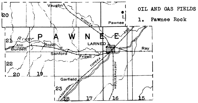
Eastern Pawnee County is crossed from southwest to northeast by the wide flood plain of Arkansas River. Sand is present both in the flood plain and in the river bed. One operator reported the production of several thousand tons of paving sand from near Larned during 1935.
All except the northwestern part of Pawnee County is manteled with terrace deposits (ancient river deposits), dune sands, or flood-plain sediment. In addition, the bed rock beneath much of the mantle rock is Dakota sandstone, which is tapped in some parts of the county by moderately deep wells and usable water obtained. The mantle-rock deposits contain sufficient water for local needs at shallow depths.
The thickest bed of bentonite known in the state occurs in Phillips County in the NE of sec. 35, T. 1 S., R. 20 W., 1 1/2 miles south of Long Island. This bed is 5 feet thick. Bentonite is used mainly in rotary-drilling mud and in filtering oil.
Phillips County lies high on the northeast flank of the Central Kansas Uplift. The nearest oil production is about a mile south of the county line in the Faubin pool of northern Rooks County. Several tests have been drilled in Phillips County, during past years, but without discovery of a commercial oil or gas field as yet. One well was drilled during 1932 in sec. 25, T. 5 S., R. 18 W., to a depth of 3440 feet. The top of the "Oswald lime" was encountered at 3075 and the "Siliceous lime" at 3425 feet. Good oil shows appeared at depths of 3097, 3137, 3195, and 3S80 feet. A well in section 24 of the same township was drilled to a depth of 3455 feet in May, 1934, but without success. Considerable leasing took place in southwestern Phillips County during the past year.
At least one large deposit of volcanic ash occurs in Phillips County. This deposit is southwest of Speed, about 1 1/2 miles north of the Rooks County line. The tonnage has been estimated at one-half million. This ash is of unusually high quality, with 60 per cent passing through the 200-mesh screen.
The Materials Department of the State Highway Commission has mapped several workable sand and gravel deposits in southern and western Phillips County.
Pottawatomie County is bounded on the west by Big Blue River, and on the south by Kansas River. Abundant supplies of water are available in the flood plains of these streams and their larger tributaries. Surface waters are impounded for the municipal supply at Onaga. In the upland areas successful wells have been dug or drilled into a number of bed-rock aquifers. As a general rule this water is hard, but potable. Adequate farm supplies have been obtained in wells ranging from but a few feet to nearly 200 feet, from the following bed-rock formations: Florence flint, Wreford, Cottonwood, Neva, and lower Elmdale shale.
Both sand and gravel deposits, and limestone beds, have been exploited in Pottawatomie County. The sand and gravel occur along the Big Blue and Kansas rivers, especially along the latter. The limestones are drift-covered in some parts of the county, but are well exposed, and have been quarried along the north side of Kansas River valley in the vicinities of Wamego and St. George. The Tarkio limestone is especially well exposed.
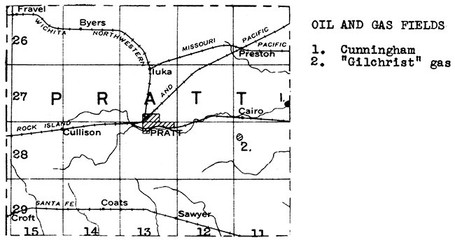
The western edge of the Cunningham pool of Kingman County extends over the line into eastern Pratt County. Several oil wells have been drilled in sec. 25. T. 27 S., R. 11 W., Pratt County. As in the case of the wells on the Kingman County side of the line, oil is obtained from both the Kansas City "lime" and the "Siliceous lime". A large amount of gas accompanies this oil.
A one-well gas pool was discovered in February, 1936, about 6 miles southwest of the Cunningham field. The well had an initial yield of about 14 million feet of gas. It was drilled to a depth of 4435 feet.
A number of tests have been drilled in other parts of Pratt County which encountered good shows of gas and oil. One well 9 miles east of Pratt had 1 1/2 million cubic feet of gas in the Viola lime at 4,259 feet. A well in the northwestern part of the county, in sec. 7, T. 26 S., R. 15 W., had a show of gas in the "Oswald lime" at a depth of 3870 feet, an oil show at 3935 feet, and a million feet of gas at 4300 feet. This test was dry and abandoned at a depth of 4956 feet. A well in sec. 15, T. 27 S., R. 14 W. had a small show of oil in the base of the Kansas City "lime" from 4094 to 4098 feet, and the well was eventually abandoned at 4355 feet. About 3 miles west of the western edge of the Cunningham field (as now outlined), in sec. 28, T. 27 S., R. 11 W.. a well was drilled to a total depth of 4427 feet in 1933. Several showings of oil and gas were encountered.
A leasing campaign recently took place in southwestern Pratt County, following extensive core drill and seismograph surveys.
Practically all of Pratt County is cover-ed by Tertiary river deposits and dune sand. Over most of the county sheet water is available at a relatively moderate depth.
The State Geological Survey has two records on file of volcanic ash deposits in Pratt County. One of these is in the SW. cor. of sec. 23, T. 27 S., R. 11 W. This deposit has an unusually high content of clay. It is doubtful if it has commercial possibilities. The other deposit is in sec. 22., T. 27 S., R. 12 W. This ash bed varies in thickness from 2 to 7 feet, and its owner estimates that 30,000 tons are available beneath an overburden ranging from 2 to 6 feet.
Pratt County is largely covered with Tertiary stream sediment in which workable deposits of sand and gravel are numerous.
Most of Rawlins County is veneered with the Tertiary formation of Ogallala age. The county is drained from southwest to northeast by Little Beaver Creek, a tributary of the Republican River. Large quantities of water are available at shallow to moderate depths, both in the valley fills and the Ogallala formation. Some use is being made of sheet water for irrigation in this part of the state.
Several deposits of volcanic ash occur in Rawlins County, of which the largest are in the vicinity of Beardsley. Two deposits in this neighborhood have been exploited in the past, but no production was reported from this area during 1935.
The Wray or Beecher Island gas field in Colorado, near the northwestern corner of Kansas, is the nearest field to Rawlins County. The closest production in Kansas is some distance to the southeast in Rooks and Trego counties. Only one deep test has been drilled in Rawlins County, so the oil and gas possibilities of this area are still largely unknown. This well was drilled in sec. 3, T. 2 S., R. 35 W., in 1932. It was abandoned at a depth of 3939 feet in the Pennsylvanian after encountering oil shows at 3369, 3520, and 3737 feet. There is no reason known at the present time why storage of oil and gas cannot occur in the buried rocks in this district. The formations which produce most of the gas and oil to the southeast are deeply buried beneath Rawlins County, but there is a possibility of oil and gas in higher formations, including those of Cretaceous age.
A sand and gravel deposit has been mapped along Little Beaver Creek west of Atwood. Outcrops of "Mortar beds" along the same creek northeast of Atwood may be quarried in the future for stone.
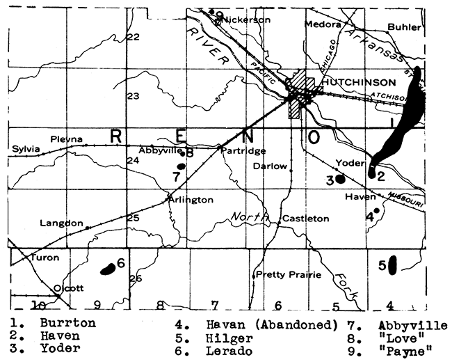
Reno County first entered the producing column in 1927, with the completion of the discovery well of the Abbyville pool. However, it was not until 1932 that the county became an important producer, through the deepening of a gas well drilled the year before in the Burrton pool. Subsequently, the Burrton pool has become the largest pool in the state, with a yield of over 5 1/4 million barrels during 1936. Four additional fields were discovered between 1934 and 1936. Some facts in regard to Reno County fields are given in the following table.
| Name of field | Discovery date | Producing formation | Depth |
|---|---|---|---|
| Abbyville | Jan., 1927 | Kansas City "lime" | 3,540 ft. |
| Burrton | April, 1931 | Mississippian "chat" | 3,370 ft. |
| Hunton "lime" | 3,590 ft. | ||
| "Siliceous lime" | 3,780 ft. | ||
| Haven | Sept., 1935 | Mississippian "chat" | 3,380 ft. |
| Hilger | April, 1934 | Viola "lime" | 4,000 ft. |
| Yoder | Oct., 1935 | Mississippian "chat" | 3.450 ft. |
The Reno County production in 1936 was 5,984,634 barrels. Most of this came from the Burrton pool. Eastern Reno County has been core drilled and western Reno has been both core drilled and surveyed by seismograph. Leasing was active during 1936 in both parts of the county.
The Empire Oil and Refining Company has a natural gasoline plant, which produces gasoline from gas obtained in the Burrton field by the absorption process.
Up to 500 feet of salt underlies the central part of Reno County. Three plants, the Barton Salt Company, the Carey Salt Company, and the Morton Salt Company, reported production in this county during 1935. Salt was obtained by both brine wells and underground mining. The quantity produced from brine wells was greater than the rock salt mined. The total production for Reno County during 1935 was 241,388 tons of salt, valued at $798,529. This was about 40 per cent of the total salt production for the state.
The Arkansas River flows across northeastern Reno County from northwest to southeast. A large supply of sand is available in the bed of this river and along some of its tributaries. One operator reported the production during 1935 of several thousand tons of structural and engine sand in this county.
Except along the north fork of Ninnescah River in southern Reno County, where Permian rocks are exposed, the bed rock is mantled with flood-plain alluvium, terrace sands and gravels, dune sand, and Tertiary deposits. It is possible almost anywhere in the flood plain of Arkansas River, and in the dune-sand areas, to obtain an abundant supply of water at shallow depths. The Tertiary cover is thin and is not everywhere water bearing. The only bed-rock aquifers present are the Cheyenne sandstone of Comanchean age, which lies between the Tertiary sediments and the Permian formations in the western part of the county, and Permian shale where fissured. Water from the latter source is mineralized in most cases.
A deposit of volcanic ash has been reported 1 1/2 miles south of Arlington in the SW of sec. 14, T. 25 S., R. 8 W. The size of this deposit is not known.
The Greenhorn limestone, which includes the thin but widely used "fence-post" bed, outcrops in eastern and southern Republic County. One operator reported the production of several thousand tons of limestone for use as road metal and in concrete during 1935.
Western Republic County is crossed from north to south by the Republican River. Gravel is abundant in the wide flood plain of this river, and a large supply of water is available almost anywhere in the river "bottoms". A large part of northern Republic County is covered by a Tertiary silt, sand, and gravel deposit, known as the Belleville formation. An excellent supply of water is available in this formation. although it may be necessary to drill to a depth of about 200 feet in order to penetrate the main aquifer. The Dakota sandstone underlies the entire county, and outcrops in the southeastern corner. A large quantity of water is stored in the sandstone beds of this formation, but unfortunately in some parts of the county it is too highly mineralized for even stock use.
No tests drilled for oil and gas in Republic County have reached the Ordovician rocks. This county is situated on the east flank of the Salina Basin, and wells drilled to test the lower formations will have to go to considerable depths.
Sand and gravel occur along Republican River and have been dredged near Scandia. Deposits also occur in the basal part of the Tertiary sediments in the northern part of the county. Some of these, north of Belleville, have been exploited.
The Cretaceous (Dakota) coal that is mined in northern Cloud County extends into southern Republic County.
Rice County became an oil producer in 1924 with the discovery of the Welch pool in the southeastern part of the county. This was the year following the discovery of the Fairport pool in Russell County, and for some years these two fields were the only oil fields in western Kansas. It is interesting to note, however, that gas was discovered in 1888 in a l,230 foot well drilled in Lyons. This was was piped to a hotel and near-by dwellings and used for some months before an explosion put a stop to the local gas industry for a period of over 35 years.
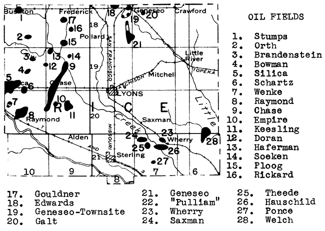
The large-scale development of oil and gas resources of Rice County did not take place until the summer of 1929 when the Raymond field in the western part of the county was discovered. Subsequently about two dozen new fields have been discovered, mainly west and north of Lyons. Rice County led the state during 1936, with a production of 11,427,072 barrels, or about 20 per cent of the state's total. One of the Rice County fields the Silica, produced over 3 3/4 million barrels during 1936, and the Chase pool produced nearly 3 1/2 million barrels of oil. The Raymond pool, a relatively old pool for this vicinity, continues to be important, yielding over a million barrels during 1936.
Rice County lies on the southeastern "nose" of the Central Kansas Uplift. Most of its production is obtained from Ordovician rocks. A compilation of the oil and gas fields of this county follows:
| Name of field | Discovery date | Producing formation | Depth |
|---|---|---|---|
| Bowman | Aug., 1936 | "Siliceous lime" | 3,290 ft. |
| Brandenstein | Nov., 1933 | Kansas City "lime" | 3,018 ft. |
| Chase | Dec., 1932 | "Siliceous lime" | 3,200 ft. |
| Doran | Oct., 1936 | "Siliceous lime" | 3,300 ft. |
| Edwards | Mar., 1936 | "Siliceous lime" | 3,330 ft. |
| Empire | June, 1936 | "Siliceous lime" | 3,275 ft. |
| Galt | Oct., 1935 | "Siliceous lime" | 3,225 ft. |
| Geneseo | May, 1934 | "Siliceous lime" | 3,255 ft. |
| Gouldner | July, 1935 | Kansas City "lime" | 3,000 ft. |
| "Siliceous lime" | 3,162 ft. | ||
| Haferman | Aug., 1936 | "Siliceous lime" | 3,245 ft. |
| Hauschild | May, 1936 | Conglomerate | |
| Keesling | Aug., 1935 | "Siliceous lime" | 3,255 ft. |
| Orth | July, 1932 | "Siliceous lime" | 3,237 ft. |
| Ploog | July, 1930 | "Siliceous lime" | 3,250 ft. |
| Ponce | June, 1936 | Mississippian "Chat" | 3,400 ft. |
| Raymond | July, 1929 | Kansas City "lime" | 3,140 ft. |
| Conglomerate | 3,280 ft. | ||
| "Siliceous lime" | 3,350 ft. | ||
| Rickard | Sept., 1935 | "Siliceous lime" | 3,350 ft. |
| Saxman | Dec., 1936 | Mississippian "chat" | 3,350 ft. |
| Schartz | July, 1936 | "Siliceous lime" | 3,300 ft. |
| Silica | Oct., 1931 | "Siliceous lime" | 3,000 ft. |
| Soeken | Jan., 1937 | "Siliceous lime" | 3,309 ft. |
| Stumps | May, 1935 | "Siliceous lime" | 3,940 ft. |
| Theede | Jan., 1937 | Conglomerate | 3,355 ft. |
| Welch | Jan., 1924 | Mississippian "chat" | 3,400 ft. |
| Wenke | Mar., 1935 | "Siliceous lime" | 3,370 ft. |
| Wherry | Sept., 1933 | Mississippian "chat" | 3,375 ft. |
Rice County is underlain by salt beds with an aggregate thickness exceeding 300 feet. Two operators reported production of both evaporated and rock salt during 1935. The mines and brine wells are located in and near Lyons. A third mine in the eastern part of the county at Little River has not operated for some years. However, it is being kept in condition and can be re-opened at any time should market conditions justify it.
The Dakota formation is exposed at the surface in northeastern Rice County. Practically all of the remainder of the county is covered by mantle rock, including flood-plain alluvium, terrace deposits, and dune sand. Ordinarily sufficient water can be obtained from the mantle-rock deposits, but in very dry years water becomes unobtainable in some places. The best bed rock aquifer is a sandstone bed in the lower part of the Dakota formation. Unfortunately, this sandstone is lenticular and some wells have missed it. It yields a good supply of water in dry and moist years alike.
Sand and gravel are abundant In the broad flood plaIns of Arkansas River and Cow Creek in the southern half of Rice County.
The Dakota formation which outcrops in eastern and northeastern Rice County is a potential source of stone.
A series of limestone beds from the Americus to the Fort Riley crosses Riley County. The most exploited is the Cottonwood, which is well exposed, and has been quarried extensively in the vicinity of Manhattan. Cottonwood limestone has been used as a building stone, and many dwellings and buildings in Manhattan, including those on the College campus, are built with this stone. One operator reported production of building stone, including rough architectural and dressed stone, in Riley County during 1935. The same operator produced acme flagstone. Riley County is one of the few places in the state where building stone, once an important industry in Kansas, has been quarried in recent years.
A large supply of sand and gravel is available in Riley County in the beds and flood plains of the Kansas and Big Blue rivers. Dredging, operations have been carried on at Manhattan and near the northeastern corner of the county. A small production was reported during 1935.
Flood plains constitute a very important source of water in Riley County. In the vicinity of Manhattan, where the Kansas and Big Blue rivers merge, it is possible to obtain a large supply of water at almost any point on the valley floor at shallow depths. The upland areas are limited in water supply, and those desiring water must either seek it in the narrow flood plains of the tributary streams or attempt to develop a bed-rock supply. Some of the massive limestones, such as the Wreford, are extensively fractured and carry a fair supply of water in the openings.
Eastern Riley County overlies the Granite Ridge, and wells have encountered pre-Cambrian formations at relatively shallow depths. The sedimentary section is much thicker, however, in western Riley County and a test located on a local structure there might encounter oil or gas in paying quantities. A very short distance to the west of Riley County, in Clay County, a 20-barrel oil well was drilled about 10 years ago.
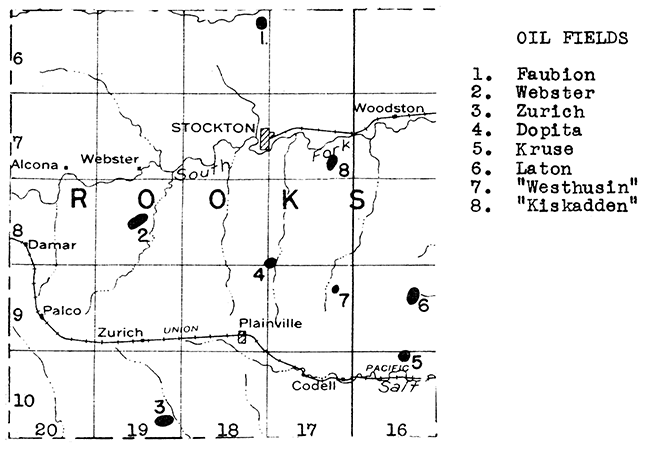
The discovery well for Rooks County was drilled in July, 1927, in sec. 11, T. 9 S., R. 16 W. The pool thus discovered was named the Laton. Subsequently five other pools have been discovered in this county, and one of them, the Faubin, is the northernmost pool in the state. So far all of the fields discovered in Rooks County are small, with from one to four producing wells in each pool. The total production for the county-during 1936 was 40,831 barrels. A tabulation of the Rooks County fields follows:
| Name of field | Discovery date | Producing formation | Depth |
|---|---|---|---|
| Dopita | July, 1934 | "Siliceous lime" | 3,415 ft. |
| Faubin | March, 1936 | Kansas City "lime" | 3,058 ft. |
| Laton | July, 1927 | "Oswald lime" | 3,292 ft. |
| Webster | Oct., 1930 | Kansas City "lime" | 3,225 ft. |
| Conglomerate | 3,450 ft. | ||
| Westhusin | Sept., 1936 | "Oswald lime" | 3,200 ft. |
| Zurich | Sept., 1935 | Kansas City "lime" | 3,300 ft. |
Southern and western Rooks County have been both core drilled and surveyed by seismograph parties. Leasing has been active recently in the western and northwestern parts of the county.
The south fork of Solomon River extends across Rooks County from west to east. The flood plain of this river contains sand and gravel in commercial amounts at numerous places. Some sand and gravel have also been obtained from low terraces along Solomon River and Bow Creek, in the northwestern corner of the county. In addition are scattered sand and gravel deposits of the high-terrace type, in which limestone pebbles derived from the Niobrara formation are abundant. One operator reported production of structural gravel in Rooks County during 1935.
The uplands in northwestern and southwestern Rooks County are covered with the Ogallala formation. Water is fairly abundant in the Tertiary rocks, except along the valley edge where drainage has taken place. The rest of the county is underlain with Niobrara chalk, and to a much lesser extent with the Carlile shale. The Codell sandstone at the base of the Niobrara formation carries water, as do sand lenses in the much deeper Graneros shale. The sands in the Dakota are full of water, but in many parts of the county this water is too salty to be used. A consistent supply of water is obtainable at shallow depths in the flood plain of the south fork of Solomon River. A less consistent supply is available in the narrower flood plains of tributary streams.
At least two deposits of volcanic ash occur in Rooks County. One is in sec. 7, T. 8 S., R. 16 W., about 6 3/4 miles south of Woodston, and the other is about 1 1/2 miles southeast of Webster. So far as is known, these deposits have not been exploited to any extent as yet. Both are several miles from the railroad.
Tertiary "mortar beds" and massive ledges of Fort Hays limestone constitute potential sources of stone in this county.
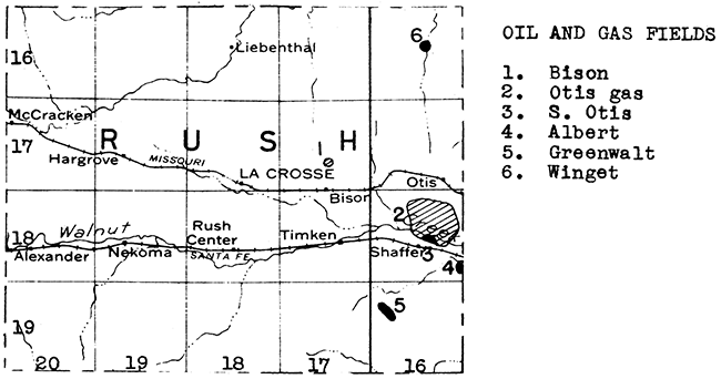
The discovery well for Rush County was the Bison-gas-well drilled in sec. 27, T. 17 S., R. 17 W. in November, 1928. This well produced from conglomerate at a depth of 3,575 feet. Subsequent offset drilling failed to enlarge the field, and it is reported as not producing at the present time. The second discovery was an oil well in sec. 17, T. 19 S., R. 16 W. This well, the Greenwalt, was completed in October, 1931, in the "Siliceous lime" at a depth of 3,263 feet. It was abandoned in August, 1934.
One of the important gas fields of central-western Kansas, the Otis, was discovered by a well in eastern Rush County completed in March, 1930. Subsequent drilling has shown the gas area to be at least 4,800 acres in extent. The producing formation is a basal Paleozoic sand at a depth of about 3,600 feet. During the development of this field an oil well was completed in the southern part, in August, 1934. Subsequently, seven other wells in the field have struck oil, and several more are drilling. The pool apparently is not as extensive as the gas-producing area.
The Winget pool, near the northeastern corner of the county was discovered by a well completed in December, 1936. This well is producing from the Kansas City "lime". At the present time three offset wells are being drilled.
The Albert pool of western Barton County extends across the Rush County line into sec. 36, T. 18 S., R. 16 W., a short distance southeast of the present limit of the Otis field.
Most of Rush County is floored with the Carlile shale, which is too dense a formation for the storage of any appreciable quantity of water. However, the entire county is underlain by the Dakota sandstone, which carries potable water in this part of the state, and which is tapped for the water supplies of La Crosse and other communities. South-central Rush County is crossed from west to east by Walnut Creek, in the flood plain of which water is available at shallow depths.
An excellent quality white, rock wool has been blown from a mixture of Greenhorn limestone and sand sampled in the northern part of Rush County. The same rocks are available elseWhere in the county, much closer to rail transportation and gas fuel.
Sand and gravel occur along Smoky Hill River in northern Rush County.
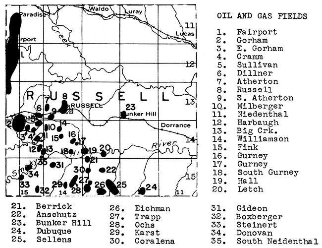
The discovery well of Russell County was also the discovery oil well for western Kansas. This well was completed in the latter part of 1923 in what later became known as the Fairport pool. At that time the closest field of importance was 13.5 miles to the southeast in Butler County. Other discoveries in western Kansas came slowly during the ensuing decade. Now, however, Russell County has three dozen oil fields beside the Fairport, most of which have been discovered in the last two or three years. At first the complete development of the fields discovered was held up through lack of outlet, but recent pipe-line extensions and new construction have made marketing of Russell County oil possible, so at present the Russell-Ellis district is being rapidly explored and developed. During 1936, Russell County was second only to Rice County in the total oil production, with a yield of 7,074,226 barrels.
A compilation of the Russell County fields follows:
| Name of field | Discovery date | Producing formation | Depth |
|---|---|---|---|
| Anschutz | April, 1936 | Topeka "lime" | 2,858 ft. |
| "Siliceous lime" | 3,327 ft. | ||
| Atherton | July, 1935 | "Oswald lime" | 3,030 ft. |
| "Siliceous lime" | 3,290 ft. | ||
| South Atherton | March, 1936 | "Oswald lime" | 3,120 ft. |
| "Siliceous lime" | 3,307 ft. | ||
| Benso | Feb., 1936 | "Oswald lime" | 3,100 ft. |
| Herrick | Dec., 1935 | "Oswald lime" | 2,925 ft. |
| Boxberger | Dec., 1935 | "Oswald lime" | 3,140 ft. |
| Bunker Hill | Oct., 1935 | Kansas City "lime" | 2,980 ft. |
| Coralena | Oct., 1936 | Topeka "lime" | 2,760 ft. |
| "Oswald lime" | 2,975 ft. | ||
| Cram | Aug., 1935 | "Oswald lime" | 3,170 ft. |
| Dillner | May, 1930 | "Siliceous lime" | 3,000 ft. |
| Donovan | Feb., 1935 | Kansas City "lime" | 3,125 ft. |
| Dubuque | Oct., 1935 | "Siliceous lime" | 3,275 ft. |
| Dumler | Dec., 1936 | Topeka "lime" | 2,770 ft. |
| "Oswald lime" | 3,110 ft. | ||
| Eichman | April, 1935 | "Siliceous lime" | 3,335 ft. |
| Fairport | Nov., 1923 | "Oswald lime" | 3,010 ft. |
| "Gorham sand" | 3,220 ft. | ||
| Granite wash | 3,260 ft. | ||
| Fink (abandoned | Feb., 1935 | "Oswald lime" | 3,112 ft. |
| Gideon | June, 1930 | Conglomerate | 3,270 ft. |
| Gorham | Oct., 1936 | "Oswald lime" | 3,040 ft. |
| Conglomerate | 3,300 ft. | ||
| Gurney | Feb., 1935 | "Oswald lime" | 2,980 ft. |
| Granite wash | 3,220 ft. | ||
| Gurney (South) | Sept., 1936 | "Oswald lime" | 3,011 ft. |
| "Gorham sand" | 3,192 ft. | ||
| Hall | May, 1931 | "Oswald lime" | 2,950 ft. |
| "Siliceous lime" | 3,375 ft. | ||
| Harbaugh | March, 1936 | "Oswald lime" | 3,140 ft. |
| "Siliceous lime" | 3,200 ft. | ||
| Big Creek | July, 1935 | "Oswald lime" | 3,005 ft. |
| "Siliceous lime" | 3,175 ft. | ||
| Karst | Oct., 1935 | "Siliceous lime" | 3,310 ft. |
| Letch | June, 1936 | Kansas City "lime" | 3,850 ft. |
| Millberger | May, 1935 , | "Siliceous lime" | 3,310 ft. |
| Neidenthal | Aug., 1934 | "Siliceous lime" | 3,250 ft. |
| Ochs | Oct., 1929 | "Siliceous lime" | 3,352 ft. |
| Peterson | Nov., 1936 | "Siliceous lime" | 3,293 ft. |
| Rude | Dec., 1930 | "Siliceous lime" | 3,350 ft. |
| Russell | Feb., 1934 | Kansas City "lime" | 3,200 ft. |
| "Siliceous lime" | 3,275 ft. | ||
| Sellens | June, 1929 | Kansas City "lime" | 3,100 ft. |
| "Siliceous lime" | 3,350 ft. | ||
| Steinert | July, 1929 | Kansas City "lime" | 3,075 ft. |
| Sullivan | Feb., 1925 | Topeka "lime" | 2,785 ft. |
| Kansas City "lime" | 3,075 ft. | ||
| Tarkio "lime" | 2,526 ft. | ||
| "Erlich sand" | 3~060 ft. | ||
| "Gorham sand" | 3,315 ft. | ||
| "Siliceous lime" | 3,225 ft. | ||
| Trapp | March, 1936 | "Siliceous lime" | 3,250 ft. |
| Trapp North | June, 1936 | Kansas City "lime" | 3,050 ft. |
| "Siliceous lime" | 3,075 ft. | ||
| Williamson | Feb., 1936 | Tarkio "lime" | 2,525 ft. |
| "Gorham sand" | 3,294 ft. |
The original Fairport field was considerably revived a few years ago by "acidizing" the wells. The yield of many wells was temporarily restored to the original "flush" figure.
The uplands in Russell County are floored with the relatively "tight" Carlile shale and Greenhorn limestone. The underlying Graneros shale and Dakota sandstone are exposed in the stream valleys that cross the county from west to east. In northern and eastern Russell County the Dakota sandstone is a satisfactory aquifer. In western Russell County, however, some of the sand layers within this formation carry salt water. The city of Russell obtains its municipal supply from impounded surface water.
A 5-foot bed of volcanic ash is expose in the southwest corner of sec. 19, T. 14 S., R. 13 W. So far as is known, this deposit has never been exploited commercially.
Sand and gravel (including limestone gravel) deposits are exceptionally abundant in Russell County. These occur not only along the Smoky Hill and Saline Rivers and their tributaries, but also in terrace deposits on the uplands.
Sand and gravel deposits are abundant in the flood plains and channels of the Smoky Hill and Saline rivers which cross Saline County. One operator reported production of structural sand, paving sand, engine sand and paving gravel from near Salina during 1935.
A large and continuous supply of potable water is available in the valley fill of Smoky Hill and tributary rivers, including the Saline. This valley-fill material covers nearly half of the county, and although it does not everywhere yield abundant water supplies, a water-bearing gravel can be struck by relatively shallow wells in most places. The remaining half of the county, with the exception of the eastern edge, is floored with the Dakota formation, in which sandstone beds yielding potable water occur.
Attempts to extend oil and gas productIon northward from McPherson County into Saline County have so far been unsuccessful. Six tests, ranging in depths from 3289 feet to 3579 feet, have been drilled in the last four years. These were all located in the eastern half of the county.
The western outpost of oil production in Kansas was pushed two counties westward with the discovery of oil in southern Scott County in January, 1935. Subsequently, two other producing wells have been drilled in this field, known as the Shallow Water. The total production for the field in 1936 was 34,050 barrels. The oil is unusually heavy, with a gravity of 26 degrees. It occurs in the Mississippian "lime" between 4,670 and 4,750 feet. At present there is no outlet for the oil other than by truck, but it is reported that a refinery is under construction in Scott City to handle the production from this field.
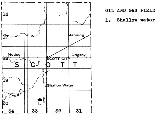
Central and southern Scott County lie in the so-called Shallow Water Basin, where a large volume of water is available at depths ranging from 20 to 75 feet. The aquifer is the Ogallala formation of Tertiary age, which covers practically all of the county. The availability of this water at shallow depth has led to pumping and irrigation over a wide belt extending from Scott City southward into northern Finney County. The Shallow Water Basin has been described in Circular 5 of the State Geological Survey of Kansas: "Preliminary report on ground water resources of the Shallow Water Basin in Scott and Finney Counties, Kansas" by Rycroft G. Moss.
Sand and gravel occur in the Tertiary sediments of Scott County. One deposit in the south central part of the county has been mapped.
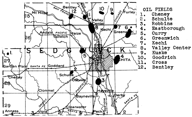
It was not until thirty-six tests had been drilled for oil and gas in Sedgwick County that commercial production was obtained. This well, which opened up the Valley Center field, was completed in August, 1928. Now the county has a dozen oil and gas fields. The total production during 1936 was 2,002,314 barrels. The Valley Center pool is still the largest one in the county, producing over a half million barrels during 1936.
The Sedgwick County fields produce from a variety of formations. A compilation of these fields follows:
| Name of field | Discovery date | Producing formation | Depth |
|---|---|---|---|
| Bentley | March, 1934 | "Oswald lime" | 2,912 ft. |
| Cheney | Nov., 1935 | Viola "lime" | 4,020 ft. |
| Cross | March, 1929 | Kansas City "lime" | 2,700 ft. |
| Curry | Oct., 1929 | Viola "lime" | 3,390 ft. |
| Schulte | May, 1934 | "Wilcox sand" | 3,660 ft. |
| Valley Center | Aug., 1928 | Kansas City "lime" | 3,660 ft. |
| Goodrich | Dec., 1928 | Kansas City "lime" | 2,616 ft. |
| "Mississippi lime" | 3,020 ft. | ||
| Misener dolomite | 3,334 ft. | ||
| Kuske | Jan., 1929 | "Mississippi lime" | 3,064 ft. |
| Kechi | April, 1929 | Penn. basal sand | 3,008 ft. |
| Greenwich | April, 1929 | "Mississippi lime" | 2,923 ft. |
| Top of Simpson | 3,168 ft. | ||
| "Wilcox sand" | 3,352 ft. | ||
| "Siliceous lime" | 3,361 ft. | ||
| Eastborough | Aug., 1929 | Mississippian "chat " | 2,960 ft. |
| Misener dolomite | 3,250 ft. | ||
| Robbins | April, 1929 | "Mississippi lime" | 3,090 ft. |
The largest natural gasoline plant in the state, with a capacity of 40,000 gallons per day, is located in Wichita. This plant uses the absorption process.
Local clays are utilized in Wichita in two plants, one a face brick plant, and the other a brick and tile plant.
Most of Sedgwick County is mantled by Tertiary deposits, Quaternary terrace sands and gravels, and Recent alluvium. The Wellington shale, which includes the Carlton limestone member, is exposed along the eastern end of the county. One operator reported limestone production for use in road metal and concrete during 1935.
A large supply of sand and gravel is available in Sedgwick County from the river bed of Arkansas River and terrace deposits. Four operators reported production during 1935 of a large tonnage of sand, which was used mainly as structural and paving sand. Lesser uses include blast, engine, and railroad ballast sand.
A large supply of water is available in Sedgwick County in the mantle rock deposits, especially in the flood plain of Arkansas River. Wells dug or drilled into the valley fill rarely fail to penetrate a gravel bed carrying a large supply of water. Unfortunately, in many parts of the county the salt content of this water is high enough to be noticeable to the taste. A much better quality water is available in the northern part of the county where the water in the Harvey and McPherson County Equus beds drains into the Arkansas river valley fill.
An exceedingly fine white rock wool was blown from samples collected in the Wichita area by the State Geological Survey in 1936.
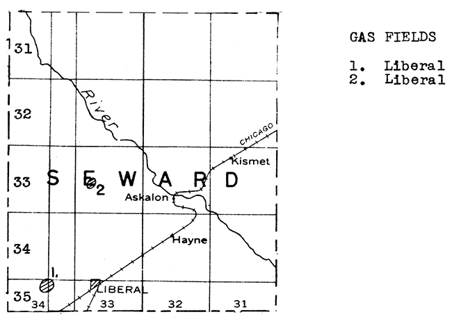
The first producing well in western Kansas was a gas well completed in southwestern Seward County in December, 1922. This well, in sec. 3, T. 35 S., R. 34 W., had an initial production of 5,000,000 cubic feet of gas at a depth between 2,718 and 2,755 ft. Two years later a million foot gas well was drilled in sec. 20, T. 33 S., R. 33 W. These two centers of gas production in western Seward County are now thought to belong in the great southwestern Kansas gas field, which was subsequently developed outward from the vicinity of Hugoton in Stevens County. It is reasonable to assume that all of western Seward County, at least, is underlain by gas-bearing strata. The eastern margin of the gas-producing belt is not known as yet with any certainty. Two wells, one in sec. 33, T. 32 S., R. 34 W. and the other in sec. 14, T. 33 S., R. 33 W., encountered small shows only in the gas sand. The possibilities of deep oil production in Seward County have not yet been thoroughly investigated.
Seward County is covered with the Ogallala formation of Tertiary age, with sand dunes here and there. The Cimarron River crosses the county from northwest to southeast. Sand and gravel deposits occur within the Ogallala formation, and are especially abundant in the alluvium and abandoned channels of Cimarron River. One operator reported production of paving gravel during 1935.
Water is available over most of Seward County by means of moderately deep wells into gravel beds in the lower part of the Ogallala formation. Another and shallower source of supply is the alluvium of Cimarron River.
A 7 1/2 foot volcanic ash bed occurs in eastern Seward County 4 miles southwest of the town of Kismet, adjacent to the Rock Island Railroad right of way. This deposit was worked about a decade ago.
A series of limestones crosses Shawnee County from north to south. The more important formations in this group include the Lecompton, Deer Creek, Topeka, Howard, Burlingame, Emporia, and Tarkio. Several of these limestones have been quarried in the north central and west central parts of the county. Two operators reported production of limestone for use in road metal and concrete during 1935.
An abundant supply of sand and gravel is available in the bed of Kansas River, which crosses northern Shawnee County from west to east. Three operators dredged sand and gravel during 1935, according to the statistical report of the U. S. Bureau of Mines. The chief products marketed were structural sand, paving sand, structural gravel, and paving sand, and miscellaneous sands were dredged.
Municipal and industrial supplies of water are available in northern Shawnee County from the Kansas River and its wide flood plain, which yields abundant water at shallow depths. The remainder of the county is dependent upon shallow wells into the valley fills of tributary streams. The deeper bed-rock aquifers in this part of the state contain highly mineralized water.
Bricks have been made from clay mined a short distance south of Kansas River near the western edge of Topeka. This plant is not operating at present.
Nine wells have been drilled into pre-Pennsylvanian rocks in Shawnee County. Two wells went entirely through the sedimentary series to the pre-Cambrian granite. One of these, in sec. 12, T. 12 S., R. 16 E., encountered the top of the granite at 3,015 feet. The other, in sec. 14, T. 11 S., R. 16 E., entered granite at a depth of 3,010 feet. The "Siliceous lime" was 530 feet thick in the first well, and 440 feet thick in the second. The Simpson ("Wilcox") sandstone in this part of the state is 70 to 100 feet thick. Although so far the wells penetrating the Ordovician formations in Shawnee County have encountered only water, the county cannot be said to have been adequately tested.
Practically all of Sheridan County is covered with the Tertiary Ogallala formation. Gravel beds in this formation yield abundant quantities of usable water at moderate depths.
Except for the eastern end, Sheridan County has not been explored for oil or gas. Two deep tests have been drilled in the eastern-most tier of townships. One, in sec. 27, T. 7 S., R. 26 W., was completed in November, 1932, at a depth of 4540 feet. A show of gas was reported at 3625 feet. The other well was drilled in sec. 34, T. 9 S., R. 26 W. It was abandoned in February, 1937, at a depth of 4663 feet. The nearest oil field at the present time is to the southeast in northern Trego County. Leasing was active in the southeastern part of Sheridan County during 1936.
Sheridan County contains at least four deposits of volcanic ash, two in the vicinity of Hoxie and two lying north of Tasco in the east-central part of the county. About 10 years ago some of these deposits were undergoing active exploitation. The amount of volcanic ash remaining is not known.
Recent streams have reworked the Tertiary sands and gravels into commercial deposits, especially in southwestern and east central Sheridan County.
Sherman County is entirely covered by a relatively thick veneer of Tertiary rocks. Local supplies are available at shallow depths, and larger supplies can be obtained by moderately deep wells drilled into the gravel beds that nearly everywhere lie at the base of the Ogallala.
The deeper formations beneath Sherman County have not yet been explored for oil and gas. The nearest producing field is the Wray or Beecher Island gas field to the northwest in eastern Colorado, and the nearest deep test was drilled to the southeast in southern Logan County. In northwestern Kansas there is a possibility of production from Cretaceous and Permian rocks, in addition to the deeper formations which are productive to the eastward in Trego, Ellis, Rooks, and Russell counties.
The presence of volcanic ash on the south bank of Smoky Hill River in southeastern Sherman County has been reported.
Sand and gravel occur in the Tertiary sediments that mantle Sherman County. A potentially commercial deposit just west of Goodland has been mapped by the State Highway Commission.
Most of Smith County is floored with the Niobrara formation, with the Hays chalk member, which lies at the base of this formation, lying at the surface in the southern and southeastern parts of the county. The Ogallala formation of Tertiary age veneers the surface in the northwestern part of the county, and forms a large outlier northeast of Smith Center. Quartzitic beds in this outlier have been exploited for road material. Several thousand tons of stone were quarried in Smith County in 1935 for use in road metal and concrete.
The Niobrara chalk and chalky shale which covers most of Smith County does not yield large supplies of water. The town of Smith Center is dependent upon surface water. Other town supplies are obtained by shallow wells into local valley fills. The only large alluvial deposit is along the north fork of Solomon River, in the southwestern part of the county. Other sources of ground water are the gravel zone at the base of the loess which covers much of the county, and the Codell sandstone immediately beneath the Niobrara formation.
Smith County lies between the Central Kansas Uplift on the west and the bottom of the Salina Basin to the east. The Ordovician formations are deeply buried in this part of the state. The county has not yet been adequately tested for oil and gas resources.
One deposit of volcanic ash is known in Smith County. This deposit lies 2 miles west of the town of Kensington, just east of the Phillips County line. According to the owner, the maximum thickness of the ash is 22 feet. As far as is known, no attempts have been made to market this material, although the Rock Island railroad is within a half mile.
Sand and gravel occur along the north fork of Solomon River in southwestern Smith County. High terrace deposits of limestone gravel are also fairly common in the southern part.
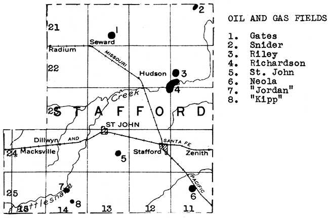
Oil was first struck in Stafford County in September, 1930 when the Richardson well was completed. Now there are seven pools in the county, with an aggregate production of approximately three-quarters of a million barrels of oil in 1936. Pertinent data on these pools follow:
| Name of field | Discovery date | Producing formation | Depth |
|---|---|---|---|
| Gates | May, 1933 | "Siliceous lime" | 3,700 ft. |
| Jordan | Jan., 1937 | "Oswald lime" | 3,780 ft. |
| Kipp | Jan., 1937 | "Oswald lime" | 3,900 ft. |
| Richardson | Sept., 1930 | "Siliceous lime" | 3,575 ft. |
| Riley | July, 1935 | "Siliceous lime" | 3,600 ft. |
| Snider | April, 1936 | Kansas City "lime" | 3,100 ft. |
| "Siliceous lime" | 3,325 ft. | ||
| St. John | May, 1935 | Kansas City "lime" | 3,600 ft. |
Stafford County is almost completely covered with dune sand. Water is available throughout this area at relatively shallow depths.
The presence of volcanic ash in southeastern Stafford County, in sec. 28, T. 25, S., R. 11 W., has been reported to the State Geological Survey of Kansas by the owner of the deposit. No data are available as to its extent.
Several sand and gravel deposits occur southwest of St. John where Tertiary rocks project through the general veneer of dune sand.
Almost all of Stanton County is veneered with the Ogallala formation of Tertiary age. Beneath is the Dakota formation, which carries potable water in this part of the state. Wells of varying depth throughout Stanton County encounter abundant supplies of water in either the coarser sand and gravel beds of the Tertiary, or in sandstone layers in the underlying Dakota.
The western edge of the southwestern Kansas gas field is ordinarily drawn across southeastern Stanton County, but no wells have been drilled in this area as yet. A dry hole has been drilled two or three miles southwest of Johnson, in the central part of the county, so it is fairly certain that the gas district does not carry that far west. This well was drilled to a depth of 3,005 feet. The possibilities of oil in the deeper rocks in this county are absolutely unknown. A deep test is now being drilled a few miles north of the Stanton County line in southern Hamilton County.
Local streams have reworked Tertiary sands and gravels in this county into workable deposits. One such deposit occurs in south central Stanton County.
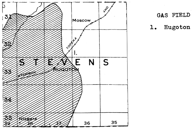
It is a possibility that every acre of Stevens County is underlain by natural gas. No unproductive wells have been drilled as yet, although over 175 gas wells have been completed in this county since the first well, which had an initial production of 7,000,000 cubic feet, was drilled in 1927 in sec. 31, T. 33 S., R. 37 W. The gas-bearing formations occur in the Big Blue series oT Permian age, The depth to the "pay" zone varies from 2,580 to 2,860 feet. Three different formations have been found to contain gas in this area, but there is some evidence that they are interconnected.
The southwestern Kansas gas field constitutes one of the great gas reserves of the country. It may continue southward across the Oklahoma Panhandle and connect with the enormous Amarillo gas field in Texas. Pipe lines carry gas from Stevens County northwestward to cities in Colorado, and eastward and northeastward to many cities in that direction.
Only one deep test has been drilled in the county, and it is reported to have stopped short of the top of the Mississippian. This well went to a depth of 5,521 feet, and was located near the western boundary of the county. Southwestern Kansas merits deeper testing for oil possibilities.
A plant near Hugoton extracts gasoline from natural gas by the absorption process. This plant has a capacity of 14,000 gallons a day.
Stevens County is entirely covered with Tertiary rocks. Sheet water is present in the coarser layers at varying depths in different parts of the county. Municipal supplies for Hugoton and Moscow are obtained from moderately deep wells.
Sand and gravel occur along Cimarron River near the northwestern corner of the county.
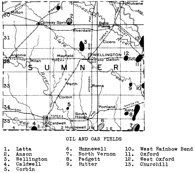
Sumner is one of the important oil counties in Kansas, with a total production in 1936 of 3,230,779 barrels. Nearly 2,000,000 barrels of this total came from the Oxford pool on the east side of the county. This pool has given spectacular proof of the oft-quoted theory that deeper oil reserves may underlie present fields. The Oxford pool was originally opened in May, 1927, and for over 8 years the 63 wells that were eventually drilled produced from shallow formations at about 1,500 feet, and the Stalnaker (Lansing) sand at about 2,050 feet. Then, in 1935, two wells were drilled into the underlying Ordovician rocks, reached at a depth of about 2,900 feet. The first well was a small one, but the second came in for nearly 9,000 barrels a day. This brought about a deepening campaign, and some of the largest oil wells ever drilled in Kansas resulted. One well was credited with an estimated initial production of 37,466 barrels a day. The relatively small Oxford pool became a very important field in Kansas. A compilation of the oil and gas fields of Sumner County follows:
| Name of field | Discovery date | Producing formation | Depth |
|---|---|---|---|
| Anson | April, 1928 | Howard "lime" | 1,940 ft. |
| Caldwell | April, 1929 | "Wilcox sand" | 4,772 ft. |
| Corbin | July, 1927 | "Wilcox sand" | 4,500 ft. |
| Latta | June, 1927 | "Oswald lime" | 3,050 ft. |
| Wellington | Dec., 1929 | Mississippian "chat" | 3,662 ft. |
| Oxford | May, 1927 | Emporia limestone | 1,075 ft. |
| Three Shawnee formations | |||
| Stalnaker sand | 2,050 ft. | ||
| "Siliceous lime" | 2,890 ft. | ||
| West Oxford | June, 1926 | Kansas City Group | 2,960 ft. |
| "Wilcox sand | 3,640 ft. | ||
| "Siliceous lime" | 3,670 ft. | ||
| Rutter | June, 1926 | "Mississippi lime" | 3,315 ft. |
| Padgett | May, 1925 | "Mississippi lime" | 3,455 ft. |
| "Wilcox sand" | 3,785 ft. | ||
| Hunnewell | April, 1927 | Lawrence shale | 2,275 ft. |
| Kanwaka shale | 2,148 ft. | ||
| North Vernon | June, 1915 (gas) | Severy shale | 1,508 ft. |
| Nov., 1928 (oil) | Stalnaker sand | 2,334 ft. | |
| "Mississippi lime" | 3,300 ft. |
Western Sumner County has recently been extensively surveyed by seismograph and core drill, and active leasing was taking place during 1936.
A plant near Oxford extracts gasoline from natural gas by the compression method. This plant belongs to the Shell Petroleum Company, and has a capacity of 3,000 gallons per day.
A relatively thin limestone, the Carlton, crosses central Sumner County from north to south. This bed is a member of the thick Wellington shale, which floors the eastern half of the county. The western half is underlain by red beds of Permian age. The county engineer reported a small limestone production during 1935.
Commercial depoSits of sand and gravel occur along Arkansas River in eastern and northeastern Sumner County, and in low terraces in the north central and southwestern parts of the county.
Northeastern Sumner County is crossed by the flood plain of Arkansas River, in which sheet water is available at shallow depths. The southwestern part of the county is covered by an old river deposit, in the porous layers of which a fair supply of water is available. The bed rock beneath these terrace deposits, and the Wellington shale in the central and southeastern parts of the county, contain water that is too highly mineralized for use. Local supplies, however, are available in the narrow flood plains of the streams draining the area. For a large supply, such as that required by the city of Wellington, it is necessary to impound surface water.
The surface of Thomas County is covered by the Ogallala formation of Tertiary age. Sheet water is available over practically the entire county at moderate depths.
No deep tests have been drilled in Thomas County. The nearest production is to the south in Scott County, to the southeast in Trego County, and to the northwest in northeastern Colorado (gas). The southern part of Thomas County has been covered by seismograph surveys, and there has been considerable leasing activity recently in the southeastern part. The next few years should see some deep tests drilled in this part of the state.
Local streams have reworked Tertiary sands and gravels into potentially commercial deposits in many places in Thomas County, especially in the north central and southeastern parts.
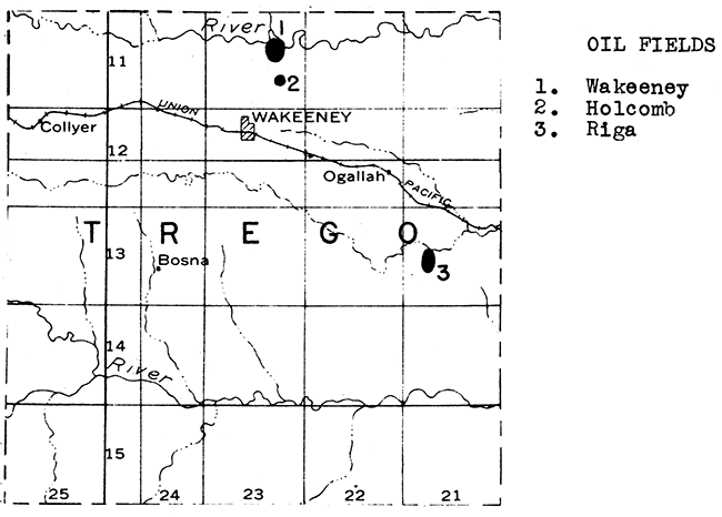
At the present time Trego County has two producing fields. A third, the Rega, which was the discovery pool of the county (May, 1929), was abandoned in 1932. The one well in this pool produced from the Pennsylvanian basal conglomerate between 3,960 and 3,972 feet. The Wakeeney pool, in secs. 10, 11, 14, and 15, T. 11 S., R. 23 W., was discovered in August, 1934. Oil occurs in the Kansas City "lime" at a depth of a little over 3,600 feet. At the present time there are nine producing wells in this field.
Two miles south of the Wakeeney pool, in sec. 26, T. 11 S., R. 23 W., the discovery well of the Holcomb oil field was completed in April, 1936. This well had an initial production of 616 barrels from the "Oswald lime". At present this field consists of two producing wells.
The production for Trego County in 1936 was 96,542 barrels. Leasing was active in the northwestern part during 1936. A large part of the county has been covered by seismograph surveys.
The uplands of Trego County are covered with the Ogallala formation in which water occurs at relatively shallow depths. Valleys, however, are floored with the Niobrara chalk and Carlile shale, which are not water-bearing formations with the possible exception of the Codell sandstone, which, where present, lies at the top of the Carlile shale. Local supplies are available in the flood plains of Smoky Hill and Saline rivers, and in the relatively narrow valley fills of their tributaries.
The county engineer of Trego County has reported the presence of two deposits of volcanic ash. One lies near the east side of the county, on the north bank of Smoky Hill Hiver, in either sec. 33 or 34. T. 14 S., R. 21 W. The other is likewise on the north side of the river, in sec. 35, T. 14 S., R. 23 W.
Samples collected from the chalk beds of northern Trego County for the purpose of blowing rock wool have not yet been tested in the experimental plant at the University of Kansas.
Sand and gravel are not only abundant along Smoky Hill River in the southern part of the county, and along Saline River in the northern part, but they also occur in workable deposits on the uplands between the two rivers.
Wabaunsee County is crossed from north to south by the Emporia, Tarkio, Americus, Cottonwood, and Wreford limestones. One operator reported limestone production for use in road metal and concrete during 1935.
Water is obtained in Wabaunsee County mainly from the flood plain of Kansas River along the north boundary of the county, and from the narrower valley alluvial deposits along the tributary streams, Some of the bed-rock limestones are sufficiently creviced to yield sufficient water for local needs.
Several dry holes have been drilled in Wabaunsee county. Two of these were in the northwestern part of the county, immediately above the crest of the Nemaha Granite Ridge. The pre-Cambrian surface was struck at a depth of 958 feet in a well in sec. 26, T. 10 S., R. 9 E., and at 1,180 feet in sec. I, T. 11 S., R. 9 E. The east flank of the Ridge is very steep, and wells drilled any distance to the east encounter a thick sedimentary section. A well in sec. 15, T. 13 S., R. l2 E. was drilled to a depth of 3,625 feet before reaching the granite surface. A well in sec. 19, T. 12 S., R. 11 E. was drilled to a depth of 3,431 feet. The last 31 feet in this well was in the Ordovician "Wilcox" sandstone. No shows of oil or gas were reported. The Ordovician formations have not been adequately tested in other parts of the county. A well in sec. 9, T. 12 S., R. 10 E. encountered a flow of helium gas.
The uplands of Wallace County are covered with the Ogallala formation, which contains sheet water in the sands and gravels lying near the base of the formation. Central and eastern Wallace County is floored with the Pierre shale. In this area it is necessary to utilize the water that is stored in the valley fills of Smoky Hill River and tributary streams.
No deep tests for oil and gas have been drilled in Wallace County. The nearest production is the Shallow Water field of Scott County to the southeast, and the Wray or Beecher Island gas field to the northwest in eastern Colorado.
Several small deposits of volcanic ash have been found in Wallace County. One of these is in sec. 8, T. 14 S., R. 38 W.
In some parts of Wallace County the Ogallala formation contains bentonitic clays with a maximum thickness of 30 feet. The largest of these deposits is in sec. 19, T. 12 S., R. 41 W. So far no attempt has been made to exploit this clay, but it has possibilities of utilization in rotary-drilling mud, and as a bleaching agent.
A large deposit of diatomaceous marl, occurring on the Marshall Ranch in northeastern Wallace County, has been described in Bulletin 18 of the State Geological Survey of Kansas. At least two other deposits of this material are known in Wallace County. Diatomaceous marl has potential economic value as raw material in the manufacture of hydraulic lime, a commercial product now being imported into the United States from Europe.
Sand and gravel deposits occur along Smoky Hill River between Sharon Springs and the Logan County line.
Most of Washington County is floored with shales and sandstones belonging to the Dakota formation. However, the Greenhorn formation, with the "fence-post limestone" bed at the top, outcrops in the uplands in western and northwestern Washington County and the Herington limestone of Permian age crosses eastern Washington County from north to south. The county engineer reported some limestone production for use in road metal and concrete during 1935.
Deposits of sand and gravel occur along Little Blue River in eastern Washington County. Some of these deposits contain reworked sand and gravel of glacial origin. One operator reported the production of a considerable quantity of' paving sand, and lesser amounts of structural sand, engine sand, and miscellaneous sand during 1935.
The county seat, Washington, obtains its municipal supply from surface water. Elsewhere in the county, except near the eastern edge, it is possible to obtain sufficient water for local and municipal supplies from sandstone layers in the Dakota formation. The eastern edge of the county is underlain by Permian rocks, and the inhabitants are dependent upon valley fills, such as the flood plain of Little Blue River, for water supplies.
Washington County has not yet been adequa ely tested for oil and gas. The county lies on the east flank of the Salina Basin, but high enough on the flank so that the depths to the Ordovician formations are not excessive.
The entire surface of Wichita County is covered with Ogallala formation. Sheet water is available in the coarser sediments of this formation at moderate depths throughout the county.
The Shallow Water oil pool of southern Scott County is only about 9 miles from the eastern boundary of Wichita County. No deep tests have been drilled in Wichita County as yet. The county has recently been covered by seismograph surveys, and leasing has been very active in the western half.
Sand and gravel deposits have been found in western and southern Wichita County.
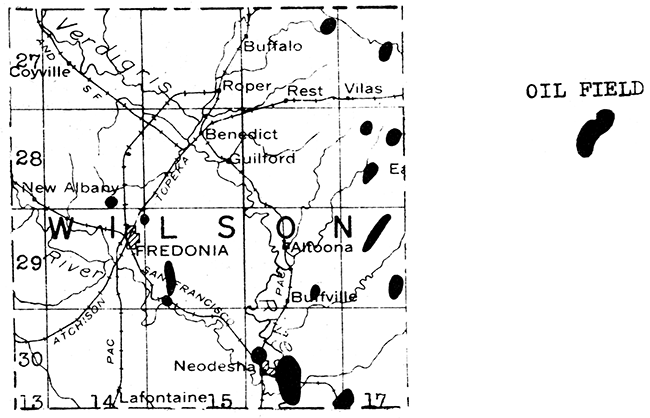
The first commercial oil well in Kansas was drilled near Neodesha in southern Wilson County nearly 50 years ago. Subsequently exploration spread over the entire county, and a large number of individual oil and gas pools were discovered. Every township in the county has produced oil or gas at one time or another. Neodesha, Altoona, Fredonia, Buffalo, and Vilas are communities that have been largely surrounded by oil and gas fields. The accompanying map shows in a general way the pools in Wilson County which are producing oil at the present time. It is interesting to note that one of these pools near Neodesha is within sight of the first oil well in Kansas. Wilson County produced 89,317 barrels of oil in 1935.
In addition to the oil wells there are about 8,000 wells at present producing some gas. The county is a network of gas lines. About 10 years ago there was considerable drilling for shale gas in eastern Wilson County. The shale gas occurs in the Fort Scott formation. Most of the other gas wells, and the oil wells, in Wilson County produce from lenticular sands in the Cherokee shale.
The "Siliceous lime" has not yet been adequately tested in Wilson County, although some relatively large wells are producing from this formation to the southwest in Elk and Chautauqua counties.
Limestones of commercial importance which cross Wilson County from north to south include the Iola, Plattsburg, and Stanton. The Stanton limestone is quarried at The Fredonia cement plant. Two operators reported a relatively small limestone production during 1935.
Three plants in Wilson County, at Buffalo, Buffville, and Neodesha, burn locally mined Clay to produce brick. The clay at Buffville is buff-firing.
Municipal and industrial supplies of water in Wilson County are obtained mainly from the Verdigris and Fall rivers. Ground water supplies occur in the alluvial deposits of these rivers and their tributaries, and in the shallower bed-rock formations. The Stranger sandstone outcrops in the western part of the county, and is a source of local ground water supplies.
Experiments by the State GeologIcal Survey at the University of Kansas have shown that satisfactory rock wool can be blown from raw materials occurring in Wilson County. The formations tested in the experimental plants are those exposed in the brick and cement company quarries at Fredonia.
High terrace flint gravel occurs in deposits of potential commercial importance in southwestern Wilson County.
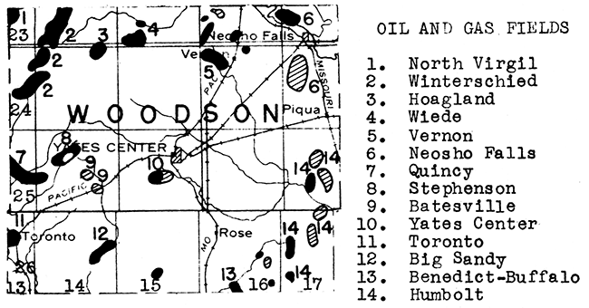
Woodson County has a number of scattered oil and gas fields. In the northeastern corner of the county is the Neosho Falls gas district with production coming from a sandy zone in the Winterset limestone at a depth of but 325 feet, and from the "Mississippi lime". Other small pools produce from the Bartlesville sand and the "Mississippi lime". A "Mississippi lime" pool lies just southwest of Yates Center. In the southwestern part of the county are the Big Sandy pool, producing heavy oil from the Bartlesville sand, and the Toronto pool, which extends across into Greenwood County. The largest oil production comes from the west-central part of the county where the southeast trending Bartlesville "shoestring sand" of the Quincy field extends across the line from Greenwood County. The Batesville pool in Woodson County also lies on this trend. The "Siliceous lime" has not yet been thoroughly tested in this part of the state.
Woodson County is crossed from north to south by the Plattsburg, Stanton, and Oread limestones. The county engineer reported limestone production for use in road metal and concrete during 1935. Suitable quarry sites have been found in south-central Woodson County.
The town of Yates Center utilizes impounded surface water for its supply. Valley fills, and sandstones occurring in the Douglas group, are used for local ground water supplies.
A flint gravel deposit occurs near the northeastern corner of Woodson County.
Wyandotte County produces no oil as yet, but has several gas fields. Among these is the Fairfax field, in the industrial district north of Kansas City, Kansas, with about 40 wells producing from two formations in the Marmaton group. The Bethel gas field, west and northwest of the town of Bethel, has about 60 gas wells producing from two sands, one in the Marmaton and the other in the upper Cherokee shale. The Welborn field, northeast of Welborn, and the Dunlap field, about 4 miles north of Bonner Springs, produce from the same formations. Scattered gas wells are found in other parts of the county. The depth to production ranges from about 225 to 700 feet.
The deepest test in the county was drilled north of Bonner Springs in sec. 20, T. 11 S., R. 23 E. to a depth of 2,200 feet. This well was abandoned in the "Siliceous lime" after penetrating it for 660 feet. The Ordovician formations have not been adequately tested in northeastern Kansas.
A cement plant is located near Bonner Springs in the southwestern part of Wyandotte County. The quarry is in the Wyandotte limestone, Bonner Springs shale, and the lower part of the Plattsburg limestones.
Wyandotte County is the leading producer of sand and gravel in Kansas. Five companies dredge these materials from the bed of Kansas River between Kansas City, Kansas, and Muncie. The chief products are structural, paving, and engine sand. Also marketed are other types of sand, and structural and paving gravel.
Southern and northeastern Wyandotte County has abundant water available in Kansas and Missouri rivers, and in the alluvial deposits of these streams. The only dependable water supply in the uplands is in the western part of the county, where the Stranger sandstone immediately underlies the surface and carries a large amount of good water. People dwelling in the uplands in the eastern part of the county are dependent upon local gravel deposits in the tributary valleys, or upon wells into bed-rock limestone near the outcrop. The water occurring in the latter environments is not abundant, and wells are prone to run dry during times of drought.
During the investigation of the rock wool resources of Kansas, conducted by the State Geological Survey, high-quality rock wools were blown from samples collected in the limestone quarry near the corner of Rainbow Ave. and Douglas in Kansas City, hansas; from the Union Pacific Railroad quarry west of Loring; and from the quarry of the Lone Star Cement plant east of Bonner Springs. With the large market afforded by the Kansas City metropolitan area, the prospects for successfully making rock wool in Wyandotte County are unusual.
(in order from youngest to oldest)
Quaternary system
Recent series
Alluvium
Dune sand
Pleistocene series
Sanborn loess
Belleville formation
Terrace deposits
McPherson formation (Equus beds)
Gerlane formation
Glacial drift
Tertiary system
Pliocene series
Ogallala formation
Cretaceous system
Pierre shale formation
Niobrara chalk formation
Carlile shale formation
Greenhorn limestone formation
Graneros shale formation
Dakota formation
Cheyenne sandstone member
Permian system
Cimarron series
Blaine formation
Enid formation
Big Blue series
Sumner group
Wellington shale formation
Carlton limestone member
Donegal limestone formation
Hollenberg limestone member
Pearl shale formation
Nolans limestone formation
Herington limestone member
Odell shale formation
Chase group
Winfield limestone formation
Gage shale formation
Towanda limestone formation
Holmesville shale formation
Barneston limestone formation
Fort Riley limestone member
Florence flint member
Blue Rapids shale formation
Kinney limestone formation
Wymore shale formation
Wreford limestone formation
Council Grove group
Speiser shale formation
Bigelow limestone formation
Easly Creek shale formation
Bader limestone formation
Stearns shale formation
Beattie limestone formation
Cottonwood limestone member
Eskridge shale formation
Grenola limestone formation
Neva limestone member
Roca shale formation
Red Eagle limestone formation
Johnson shale formation
Foraker limestone formation
Admire group
Hamlin shale formation
Fivepoint limestone formation
West Branch shale formation
Falls City limestone formation
Hawxby shale formation
Aspinwall limestone formation
Towle shale formation
Pennsylvanian system
Virgil series
Wabaunsee group
Brownville limestone formation
Pony Creek shale formation
Caneyville limestone formation
French Creek shale formation
Jim Creek limestone formation
Friedrich shale formation
Grandhaven limestone formation
Dry shale formation
Dover limestone formation
Table Creek shale formation
Maple Rill limestone formation
Pierson Point shale formation
Tarkio limestone formation
Willard shale formation
Elmont limestone formation
Harveyville shale formation
Reading limestone formation
Auburn shale formation
Wakarusa limestone formation
Soldier Creek shale formation
Burlingame limestone formation
Silver Lake shale formation
Rulo limestone formation
Cedar Vale shale formation
Happy Hollow limestone formation
White Cloud shale formation
Howard limestone formation
Severy shale formation
Shawnee group
Topeka limestone formation
Calhoun shale formation
Deer Creek limestone formation
Tecumseh shale formation
Lecompton limestone formation
Kanwaka shale formation
Oread limestone formation
Plattsmouth limestone member
Douglas group
Lawrence shale formation
Stranger formation
Missouri series
Pedee group
Iatan limestone formation
Weston shale formation
Lansing group
Stanton limestone formation
Vilas shale formation
Plattsburg limestone formation
Kansas City group
Bonner Springs shale formation
Wyandotte limestone formation
Lane shale formation
Iola limestone formation
Chanute shale formation
Drum limestone formation
Quivira shale formation
Westerville limestone formation
Wea shale formation
Block limestone formation
Fontana shale formation
Bronson group
Dennis limestone formation
Galesburg shale formation
Swope limestone formation
Ladore shale formation
Hertha limestone formation
Bourbon formation
Des Moines series
Marmaton group
Lenapah limestone formation
Nowata shale formation
Altamont limestone formation
Bandera shale formation
Pawnee limestone formation
Labette shale formation
Fort Scott limestone formation
Cherokee shale
Bartlesville sandstone member
Mississippian system
"Mississippi lime"
Chattanooga shale
Misener "sand"
Siluro-Devonian system
"Hunton lime"
Ordovician system
Maquoketa shale
"Viola lime"
Simpson formation
"Wilcox sand" member
Cambro-Ordovician system
"Siliceous lime" (Arbuckle)
Pre-Cambrian
Granite and other crystalline rocks
Kansas Geological Survey, Geology
Placed on web Jan. 28, 2016; originally published June 1, 1937.
Comments to webadmin@kgs.ku.edu
The URL for this page is http://www.kgs.ku.edu/Publications/Bulletins/MRC6/page3.html