![]()
Prev Page--Results, Start || Next Page--Discussion and Conclusions
Results, Continued
Stafford 1
Stafford 1 is a 2.50-m (8.2-ft)-deep section (figs. 7, 31), exposed by backhoe trenching, in a compound parabolic dune field in the NW NW sec. 15, T. 25 S., R. 15 W. (fig. 6). Two pedostratigraphic units were described in the profile, one in silty sand and another in dune sand (figs. 31, 32). In general, the deposits at Stafford 1 are noncalcareous, loamy, have a mean particle size ranging from medium to coarse silt, are very poorly to poorly sorted, and are very finely skewed and leptokurtic to very leptokurtic (Arbogast, 1995). The sedimentology of Unit II suggests a low-energy fluvial or lacustrine depositional environment. That of Unit I suggests a predominantly eolian environment.
Figure 31--The 2.50-m (8.2-ft)-high exposure at Stafford 1, showing the position of pedostratigraphic units and radiocarbon ages.
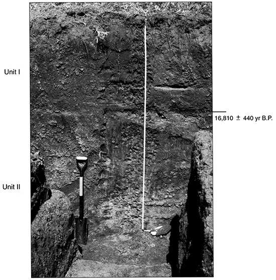
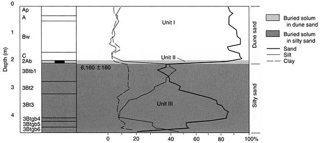
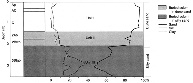
Figure 32--Pedostratigraphy, soil horizonation, and texture at Stafford 1.
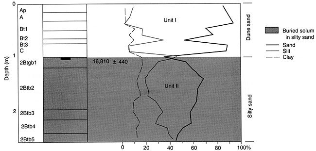
Unit II is the thickest deposit, extending from 98 cm (39 in) to the base of the profile. Deposits are generally sandy loam, containing as much as 46.4% silt and 16.6% clay (fig. 32), and are very poorly sorted. Overall, Unit II is consistent with other silty-sand deposits in the region. The degree of sorting, coupled with a subtle but steady fining-upward sequence, suggests accumulation in a low-energy alluvial or lacustrine environment during a time of increased effective moisture. Periods of exposure and relatively long-term stability must have occurred, however, as indicated by the thick, well-developed soil with prismatic structure that formed within the unit. Alternating periods of wetting and drying are suggested by soil characteristics. Towards the base, the solum is gleyed, mottled, and relatively rich in calcium carbonate, suggesting ponded water or high ground-water tables. In the middle, however, the sediment is slightly oxidized, indicating weathering in a more arid environment. In the upper part of the soil, the sediment is once again gleyed, implying a return to moist conditions. Ultimately, the soil must have been exposed again, and for some time, resulting in complete truncation of the A horizon. A radiocarbon age of about 17,000 yr B.P. from the upper part of the soil indicates that Unit II is probably a late Wisconsinan deposit. A δ13C value of -21.9‰ suggests proportionately high percentages of C3 plants inhabited the site, further implying a relatively cool climate with possibly more effective moisture.
The surficial deposit, Unit I, consists largely of single-grained sand between the surface and 98 cm (39 in) (figs. 31, 32). At the base of the unit, the deposit contains approximately 90% sand, but texture fines sharply in the middle of the stratum, with about 36% silt and 10% clay present. Towards the top of the unit, the sand content increases sharply again to around 90% (fig. 32).
Overall, the character (e.g., texture, structure, color, topographic position and expression) of Unit I is consistent with other deposits generally classified as eolian sand in the region. A sharp increase in sorting in the lowermost stratum of Unit I, as compared to the underlying deposits, is indicative of eolian sedimentation. Apparently, this change in facies occurred sometime during the late Wisconsinan, as suggested by an approximate age of 17,000 yr B.P. from the uppermost part of Unit II. Varied textures in the middle of Unit I, coupled with a sharp decrease in sorting, imply mixed alluvial and eolian deposition, possibly when the site occupied an interdunal position. Near the surface, a sharp improvement in sorting, coupled with percentages of sand of about 90%, suggests a return to eolian sedimentation.
It is difficult to estimate the age of Unit I. Evidence suggests that the unit is relatively old, possibly early Holocene. Based on the late Wisconsinan age of the underlying Unit II, the lowermost part of Unit I appears to be a late Wisconsinan deposit. Assuming no truncation, the entire thickness of Unit I would then be of a similar age. In contrast, the development of the surface soil, although excellent for one in eolian sand, does not imply great antiquity. Accordingly, it appears that an unconformity exists between the upper and lower parts of Unit I and that two periods of eolian sedimentation are represented. The development of the surface soil, with illuviated clays lining root casts, strongly suggests that Stafford 1 has been stable for a relatively long period of time for an eolian deposit on the Great Bend Sand Prairie, possibly since the early Holocene.
Stafford 2
Stafford 2 is a 3.65-m (11.9-ft)-deep section (figs. 7, 33), exposed by backhoe trenching, in a high-relief sand sheet in the NE NE sec. 24, T. 24 S., R. 13 W. (fig. 6). Four pedostratigraphic units were recognized in the profile (figs. 33, 34). In general, the deposits are noncalcareous, loamy, fine sand with a mean particle size ranging from fine to coarse silt. The sediments are poorly to very poorly sorted, consistently very finely skewed, and very leptokuric to mesokurtic (Arbogast, 1995).
Figure 33--The 3.65-m (11.9-ft)-high exposure at Stafford 2, showing the position of pedostratigraphic units and radiocarbon ages.
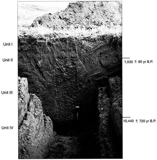
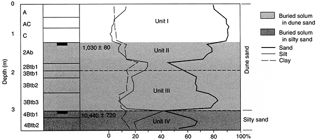
Figure 34--Pedostratigraphy, soil horizonation, and texture at Stafford 2.
The deposits at Stafford 2 can be considered as two units: Unit I, a surficial deposit of unoxidized dune sand, and Units II-IV, an underlying sequence of oxidized, siltier sediments. The origin of the upper unit can be determined with certainty. Conflicting evidence exists, however, as to the depositional environment in which Units II through IV accumulated.
Three variables suggest that Units II-IV have a fluvial origin. First, the deposit is very poorly sorted, suggesting a mixed sediment load that may occur in a low-energy fluvial or lacustrine environment. Second, a δ13C value of -23.6‰, derived from the top of the deposit, suggests that C3 plants were present in high numbers at the site, evidence of a cool climate with possibly more effective moisture. Third, the deposit contains two, well-defined fining-upward sequences, further indicative of alluvial sedimentation.
Other evidence, however, favors an eolian source for Units II-IV. Sand is a much larger component in the stratum at Stafford 2 than in other silty sands, making up as much as 85.1% (fig. 34). The radiocarbon age of approximately 10,400 yr B.P., obtained from the base of the deposit (figs. 7, 33, 34), also points to an eolian source. At other localities where the lower part of the silty sand was dated (e.g., Edwards 2 and 3, Reno 4), late Wisconsinan ages greater than 13,000 yr B.P. were derived. The age obtained from the base of Stafford 2, however, strongly suggests that the remainder of the section accumulated during the Holocene, a time of demonstrably warmer, more arid conditions. Overall, Units II through IV appear to be predominantly eolian in nature, especially in the lower part, but probably include some deposits of a very low-energy (e.g, interdune) fluvial origin. The presence of three, well-developed buried soils indicate that sedimentation was episodic and was punctuated by periods of long-term stability.
Although the origin of the underlying deposits is problematic, the surficial deposit, Unit I, clearly consists of eolian sand, for it is similar in stratigraphic position, topographic expression, age, color, texture, and structure to other deposits in the region identified as wind-blown sand. Moreover, the sorting of the upper unit, although poor, is much better than the deposits it overlies. The overall lack of sorting in the sand, in fact, suggests that Unit II, or a nearby outcrop of very poorly sorted sediments (e.g., silty sand) was the sediment source. A radiocarbon age of about 1,000 yr B.P. from the upper part of the underlying 2Ab (figs. 33, 34) provides a maximum-limiting, late Holocene age for Unit I. In addition, a δ13C value of -13.3‰ clearly implies that the associated climate was relatively warm with probably less effective moisture. The degree of surface soil development (i.e., A/AC/C horizonation) suggests that, in general, the dune field immediately surrounding Stafford 2 has been stable for a relatively short period of time, probably less than 500 years.
Stafford 3
Stafford 3 is a 4.58-m (15.0-ft)-deep section (figs. 7, 35), exposed by backhoe trenching, in a compound parabolic dune field, in the NW NW sec. 23, T. 24 S., R. 13 W. (fig. 6). Three pedostratigraphic units were recognized, Unit III in silty sand and Units I and II in eolian sand (figs. 35, 36). Skewness (finely skewed) and kurtosis (very leptokurtic to leptokurtic) are consistent in these deposits, all of which are basically noncalcareous. Unit III is much more poorly sorted, however, than the overlying deposits and contains abundant silt and clay. In contrast, Units II and I are much sandier and better sorted (Arbogast, 1995). The sedimentological differences between the lower (Unit III) and upper (Units II and I) units reflect diachronous depositional environments. Theoretically, Unit III represents a predominantly low-energy fluvial or lacustrine facies that accumulated in a wetter climate, whereas Units II and I represent eolian sedimentation in a relatively arid environment.
Figure 35--The 4.58-m (15.0-ft)-high exposure at Stafford 3, showing the position of pedostratigraphic units and radiocarbon ages.
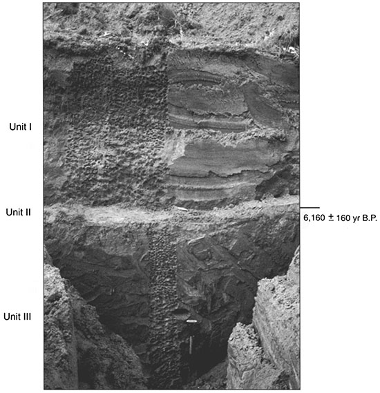
Figure 36--Pedostratigraphy, soil horizonation, and texture at Stafford 3.
Unit III is consistent with silty sands recognized elsewhere on the Great Bend Sand Prairie. The stratigraphic position of the deposit (i.e., beneath eolian sand), coupled with the degree of sorting and high percentages of silt and clay, favors this correlation. Unfortunately, deposits such as Unit III contain no sedimentary features, rendering facies categorization difficult. Sedimentologically, Unit III is very poorly sorted, indicative of a low-energy fluvial or lacustrine environment where a mixed sediment load existed. In addition, the deposit contains two, very distinct, fining-upward sequences (fig. 36), which further imply fluvial sedimentation. The deposit could be the result of both fluvial and eolian sedimentation. Because the deposit contained no measurable organic carbon, its age could not be determined through radiocarbon dating. Based on ages obtained from similar units elsewhere (e.g., Edwards 2 and 3, Stafford 1, Reno 4), which were deposited sometime between 20,000 and 13,000 yr B.P., Unit III is assigned a late Wisconsinan age.
Regardless of when and how Unit III accumulated, it is clear that following sedimentation, a stable surface existed for some time, one that promoted formation of a very strongly developed soil (fig. 36). Each horizon is strongly mottled, with the lower three heavily gleyed, suggesting that ponded water at the surface or high water tables promoted chemical illuviation. At some point, a period of surficial erosion must have truncated the A horizon from the top of the soil.
The derivation of Units II and I (figs. 35, 36) can be ascertained with relative certainty. Both are consistent in stratigraphic position, texture, cohesiveness, color, and sorting with eolian sand. Unit II, which is 11-cm (4.3-in)thick, sits unconformably on Unit III. Essentially, Unit II consists of a 2Ab horizon that formed following deposition of wind-blown sand. A radiocarbon age of about 6,200 yr B.P. from the upper part of the 2Ab (fig. 36) suggests last exposure during the middle Holocene when climate was relatively warm, and this is further indicated by a δ13C value of -17.9‰. Moreover, the age provides a maximum-limiting age for the overlying, 1.96-m (6.4-ft)-thick dune deposits of Unit I. Unit I contains a moderately developed surface soil, containing one Bw horizon. Although the 6,200-yr-B.P. age obtained from Unit II implies a middle Holocene age for Unit I, the relative lack of soil formation at the surface suggests it is younger. Apparently, an unconformity exists somewhere in Unit I, one that represents a period of erosion in the later Holocene that removed the upper part of a pre-existing dune, but did not scour Unit II. Subsequently, the remainder of Unit I was deposited and the surface soil developed. Overall, the degree of soil formation suggests that the dune has been stable for less than 1,000 years.
Stafford 4
Stafford 4 is a 3.75 m (12.3 ft) section of loess (figs. 7, 37), exposed by backhoe trenching, located in the loess plain in the NW NE sec. 16, T. 24 S., R. 12 W. (fig. 6). Although the trench was excavated to 3.75 m (12.3 ft), instability precluded sampling below 2.85 m (9.4 ft). Two pedostratigraphic units were recognized at the site (figs. 37, 38). Deposits at the site are basically noncalcareous and loamy, have a mean particle size ranging from coarse to fine silt, are very poorly sorted, and are very fine to finely skewed and very leptokurtic to mesokurtic (Arbogast, 1995).
Figure 37--The 3.75-m (12.3-ft)-high exposure at Stafford 4, showing the position of pedostratigraphic units and radiocarbon age.
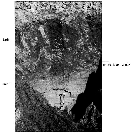
Figure 38--Pedostratigraphy, soil horizonation, and texture at Stafford 4.
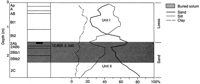
In general, the lowermost part of Unit II consists of very sandy (>83% sand), slightly laminated sediments that lack structure. The character (e.g., texture, structure, sorting) of these deposits is consistent with dune sand. In the upper part of Unit II, the sediment is much siltier (e.g., 40%) in the presence of a moderately well developed buried soil, one that consists of one 2Ab horizon, one 2ABb horizon, and two 2Btb horizons. A radiocarbon age of approximately 12,800 yr B.P. from the upper part of the soil (fig. 38) indicates that Unit II is likely a late Wisconsinan deposit. In addition, the unit is slightly oxidized (e.g., 7.5YR4/6; moist), further suggesting relative antiquity. At most localities where late Wisconsinan ages have been obtained (e.g., Edwards 1-3, Stafford 1, Reno 4), the associated deposits imply a fluvial or lacustrine facies of mixed energy. The age obtained from the 2Ab at Stafford 4 suggests that dune formation apparently occurred in some parts of the study area between 20,000 and 10,000 yr B.P. A δ13C value of -14.2‰ suggests that plants specialized for sandy, well-drained landscapes dominated the site.
Unit I conformably overlies Unit II and extends from the surface to 1.66 m (5.4 ft) (figs. 37, 38). Fundamentally, Unit I is silty, very poorly sorted, and lacks definable sedimentary structures. At first glance, the unit is similar to other strata in the study area categorized as silty sand, but in this case it is not buried. However, the radiocarbon age of approximately 12,800 yr B.P. from the underlying 2Ab (fig. 38) provides a maximum-limiting, late Wisconsinan age for the unit, a chronology recognized at several localities (e.g., Edwards 3; Stafford 11) where the silty sand has been recognized. On closer examination, however, several variables suggest that Unit I reflects a different environment from that in which the silty sand accumulated. First, the unit lies conformably over Unit II, a relationship unrecognized elsewhere in the region. Second, the deposits associated with Unit I have not been reduced or oxidized as has the silty sand at other localities. Third and most importantly, the soil horizons associated with Unit I have relatively poor structure, largely weak prismatic parting to weak subangular blocky, when compared to the moderate to strong prismatic structure observed elsewhere in the silty sand. The character of Unit I implies an eolian facies that consisted predominantly of silt at Stafford 4 rather than sand. As a result, Unit I is interpreted to be a Holocene wind-blown deposit. Apparently, the site has been stable for at least 1,000 years, as suggested by a well-developed surface soil that includes two Bt horizons.
Stafford 5
Stafford 5 is a 3.46-m (11.4-ft)-high section (figs. 7, 39), exposed by backhoe trenching, in a compound parabolic dune field in the SW SW sec. 6, T. 24 S., R. 13 W. (fig. 6). Three pedostratigraphic units were described (figs. 39, 40), one in very poorly sorted deposits of sand, silt, and clay, and two in overlying, relatively well sorted dune sand. In general, the contrasting sedimentology between Unit III and the overlying deposits appears to reflect changes in depositional environments at the site in the past 20,000 years. Two buried soils were described, indicating that sedimentation was punctuated by periods of stability and pedogenesis (fig. 40). The deposits at Stafford 5 are noncalcareous, loamy, very poorly to moderately sorted, very finely to finely skewed, mesokurtic to very leptokurtic, and have a mean particle size of medium silt to very fine sand (Arbogast, 1995).
Figure 39--The 3.46-m (11.4-ft)-high exposure at Stafford 5, showing the position of pedostratigraphic units.
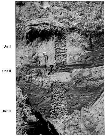
Figure 40--Pedostratigraphy, soil horizonation, and texture at Stafford 5.
Unit III ranges from 2.03 m (6.7 ft) to the base of the profile (figs. 39, 40). Although abundant in sand (e.g., 66.2%), it also contains relatively high amounts of silt (e.g., 36.5%) and clay (21.8%; fig. 40) and, as a result, is very poorly sorted. The overall lack of sorting, coupled with the presence of three fining-upward sequences in the stratum, suggest accumulation in a very low-energy fluvial or lacustrine environment. A fluvial association is tentative, however, because sedimentary structures are not preserved. Deposition must have been episodic, because the stratum contains a well-developed soil, one that consists of a heavily gleyed Btgb horizon. Implicit in the presumed sedimentary environment is a climate of more effective moisture than the present climate. In addition, the gleyed nature of the soil suggests ponded water at the surface or higher ground-water tables. Although no radiocarbon ages were obtained from Unit III, the character of the unit is consistent with other silty sands recognized elsewhere (e.g., Stafford 1, Edwards 2, Reno 4), demonstrated to be late Wisconsinan in age. As a result, Unit III at Stafford 5 is assigned a Woodfordian age.
Although the origin of the facies associated with Unit III is uncertain, the origins of Units II and I (figs. 39, 40) can be made with confidence. In general, the sediments in Units II and I consist of massive, single-grain sand that is much better sorted than the underlying deposits. The character of the deposits, coupled with their topographic position and expression, correlates very well with dune sand. Inherent in dune development is a relatively warm, arid environment, one promoting destabilization and eolian mobilization of sand. Soil development throughout Unit II, and at the surface of Unit I, indicate episodic sedimentation. Following deposition of Unit II, a brief period of pedogenesis occurred that resulted in the development of a soil with A/Bw horizonation. Although no radiocarbon ages were obtained from the 2Ab, its character (e.g., color, structure, position) suggests a middle to late Holocene age. Subsequent to development of the 2Ab, at least 1.40 m (4.6 ft) of eolian sand accumulated. The weakly developed surface soil, with A/AC/C horizonation (fig. 40), suggests that Stafford 5 has been stabilized for only a brief period of time.
Stafford 6
Stafford 6 is a 2.30-m (7.5-ft)-thick section (figs. 7, 41), exposed by backhoe trenching, in a parabolic dune field located in the SW NE sec. 29, T. 23 S., R. 12 W. (fig. 6). In general, the sediments at Stafford 6 are noncalcareous, loamy (with a mean particle size ranging from coarse silt to very fine sand), very poorly sorted to moderately sorted, very fine to finely skewed, and leptokurtic to very leptokurtic (Arbogast, 1995). Four pedostratigraphic units are recognized in the profile, with one in deposits rich in silt and three in surficial dune sand (figs. 41, 42). Essentially, these diachronous strata represent contrasting depositional regimes in the past 20,000 years that were punctuated by periods of soil formation.
Figure 41--The 2.30-m (7.5-ft)-high exposure at Stafford 6, showing the position of pedostratigraphic units and radiocarbon ages.
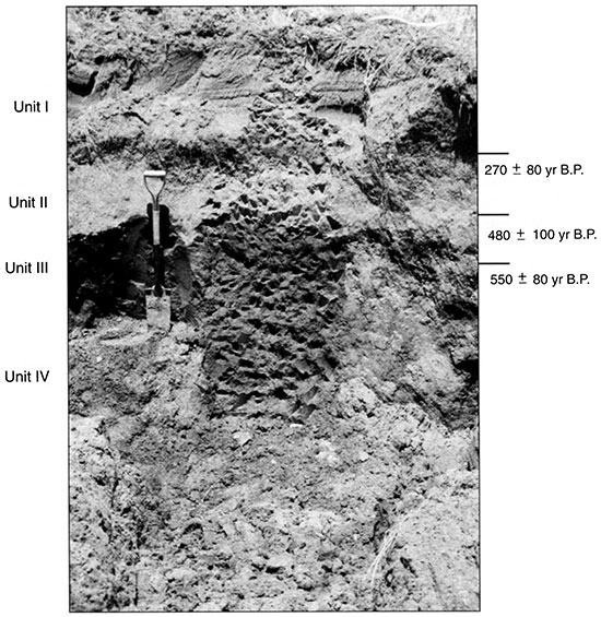
Figure 42--Pedostratigraphy, soil horizonation, and texture at Stafford 6.
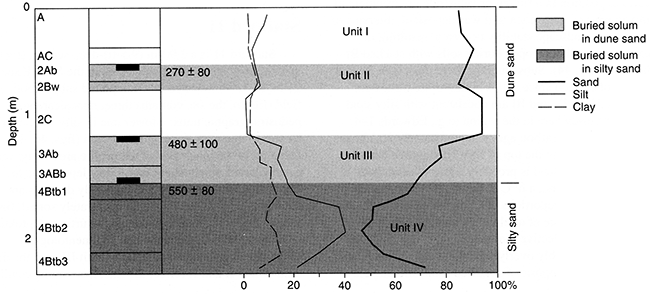
Unit IV extends from 1.52 m (4.9 ft) to the base of the profile. The deposits are loamy and very poorly sorted because of high percentages of sand, silt, and clay (fig. 42). As a result, the sediments are extremely cohesive. In its character (e.g., texture, structure, color, stratigraphic position), Unit IV is similar to other silty sands (e.g., Edwards 1-4, Stafford 1 and 2) in the region. Unfortunately, unlike other localities, sedimentary structures are not preserved that would attest to the facies. The overall lack of sorting, coupled with a clear fining-upward sequence in the middle of the deposit, suggests a low-energy fluvial or lacustrine facies. A climate that was apparently more moist than the present is also implied. Although the age of Unit IV was not estimated through radiocarbon dating, the deposit is consistent with others (e.g., Edwards 1 and 2, Reno 4, Stafford 1) assigned a late Wisconsinan age and is considered to be a late Wisconsinan stratigraphic unit. Regardless of when and how the stratum accumulated, the formation of a strongly developed soil (fig. 42) indicates that the unit was exposed for some period of time. A rather intense period of erosion must have subsequently occurred, one that truncated the 4Ab that is presumed to have existed.
A sequence of relatively uncohesive, sandy sediments, extending from the surface to 1.52 m (4.9 ft), is included within Units I to III (figs. 41, 42). The overall character of these sediments-including very sandy texture, poor structure, relatively good sorting, color, and topographic position and expression-qualify them as wind-blown dune sand. Given no significant truncation, the sequence represents at least three cycles of rapid eolian sedimentation during a relatively warm, arid climate, followed by brief periods of soil formation during periods of more effective moisture. Following deposition of Unit III, a poorly developed soil formed. Radiocarbon ages of about 550 yr B.P. from the base of the 3ABb and 480 yr B.P. from the top of the 3Ab (fig. 42) suggest that sedimentation occurred in the past 1,000 years and pedogenesis lasted for, at most, a few hundred years. Soon after this soil formed, at least 70 cm (28 in) of sediment accumulated that buried the 3Ab. Another brief period of soil formation subsequently occurred, one that altered the upper part of Unit II. A radiocarbon age of about 270 yr B.P. from the upper part of the 2Ab verifies a very late Holocene age for the overall deposit. Values of δ13C are about 15.0‰ in both buried soils, suggesting C4 plants dominated the site in the past 1,000 years. Subsequent to the development of the 2Ab, at least 53 cm (21 in) of eolian sand accumulated. The overall lack of surface soil development, which includes an A and AC horizon, coupled with the radiocarbon ages obtained from the underlying soils, suggests that Stafford 6 has been stable for a brief period of time.
Stafford 10
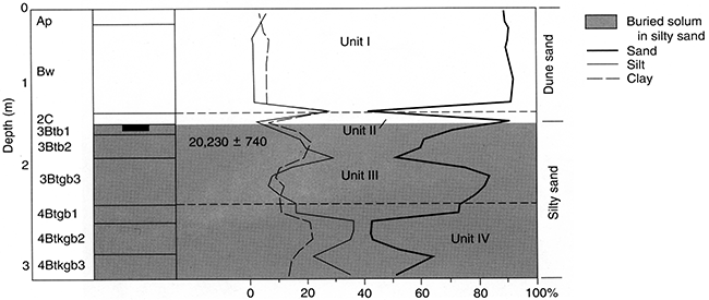
Stafford 10 is a 3.0-m (9.8-ft)-deep section (figs. 6, 43), exposed by backhoe trenching, in a compound subparabolic dune field in the SW SW sec. 11, T. 25 S., R. 15 W. (fig. 6). Four pedostratigraphic units were described in the profile, with two in silty sand and two in sand (figs. 43, 44). The silty sand is loamy, ranging from sandy loam to loam. Dune sand, in contrast, is classified as sand (fig. 44). Mean particle size in the silty sand ranges from coarse to fine silt, with two, distinct fining-upward sequences, and the deposit is very poorly sorted, fine to very finely skewed, and mesokurtic to very leptokurtic. In the dune sand, mean particle size is coarse silt to very fine sand, sorting is poor, and the deposit is very fine to finely skewed and platykurtic to very leptokurtic (Arbogast, 1995). In general, the sedimentological differences between the dune sand and silty sand appear to reflect changes in depositional environments due to a shift in climate at the site in the past 20,000 years. Both the silty sand and dune sand are basically noncalcareous.
Figure 43--The 3.0-m (9.8-ft)-high exposure at Stafford 10, showing the position of pedostratigraphic units and radiocarbon age.
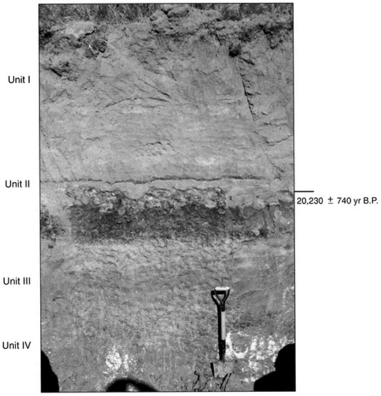
Figure 44--Pedostratigraphy, soil horizonation, and texture at Stafford 10.
In general, Units IV and III can be grouped together. Although each represents a unique period of deposition, they are sedimentologically similar because they are loamy, have relatively strong structure, and are very poorly sorted. The primary difference is color, with Unit IV being slightly oxidized. Both units are also gleyed to some degree, suggesting a period of sediment saturation. Although sedimentary features are not preserved, the presence of two, distinct fining-upward sequences indicates deposition in a fluvial or lacustrine environment of mixed energy. After each unit was deposited, intervals of long-term landscape stability occurred, resulting in extremely well developed buried soils with stacked Bt horizons (fig. 44). Subsequently, there must have been a period of erosion since soil A horizons are truncated. Overall, Units IV and III are consistent with silty sand described elsewhere in the region (e.g., Edwards 1-4, Reno 4). A radiocarbon age of approximately 20,230 yr B.P. obtained from the top of Unit III suggests that the underlying silty sand is probably a late Wisconsinan deposit. In addition, a δ13C value of -20.1‰ suggests relatively high proportions of C3 plants inhabited the site, providing evidence of a relatively cool climate with possibly more effective moisture.
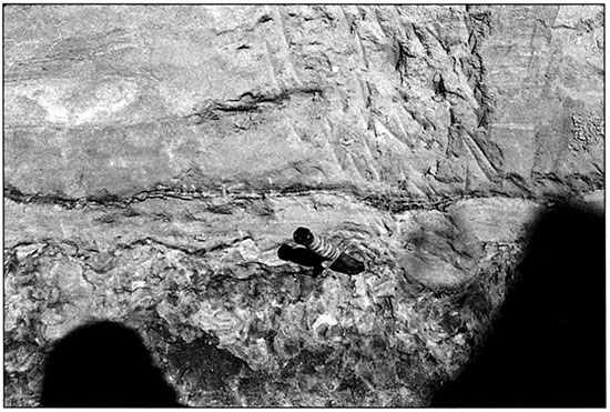
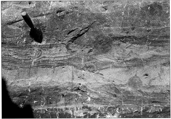
Unconformably overlying these units is Unit II, a 12-cm (5-in)-thick deposit of stratified sand, silt, and clay (figs. 43, 44). Overall, the relationship of Units III and II suggests a mixed environment, one that promoted both erosion and deposition. The contact between Units III and II is very uneven, with small channels visible in cross section (fig. 45) that indicate flowing water of unknown energy. Following truncation of Unit III, Unit II apparently resulted from fluvial processes that culminated in deposition of a 2-cm-thick silty-clay drape toward the top of the unit. Given the late Wisconsinan age of the top of Unit III, it is theorized that truncation of Unit III and subsequent deposition of Unit II occurred sometime between approximately 20,000 and 15,000 yr B.P.
Overlying Units II to IV, ranging from the surface to 1.20 m (3.9 ft), is Unit I (figs. 43, 44). Over 90% sand (fig. 44), Unit I is consistent with other deposits in the region categorized as dune sand in topographic position and expression, color, structure, and texture of the stratum. In contrast to the underlying silty sand, Unit I probably was deposited during a period of increased aridity that promoted accumulation of wind-blown sand. Conflicting evidence exists as to the time of this deposition. Based on a maximum-limiting age of approximately 20,230 yr B.P. from the upper part of the silty sand 12 cm (5 in) below the base of the dune (figs. 43, 44), it appears that Unit I is a late Wisconsinan deposit. However, Unit II may have been a much thicker deposit that was eroded during the early or middle Holocene. Because the silty-clay drape in Unit II resisted further truncation, this erosion did not reach the top of Unit III. Subsequently, eolian processes promoted deposition of Unit I on the remnants of Unit II. The Holocene age of Unit I is supported by surface soil development. Although the soil is relatively well developed, consisting of A/Bw horizonation (fig. 44), it does not appear to reflect 20,000 years of landscape stability. In fact, equilibrium throughout the Holocene is difficult to imagine. More likely, Unit I is a middle to early late Holocene deposit that has been stable only during the late Holocene.
Stafford 11
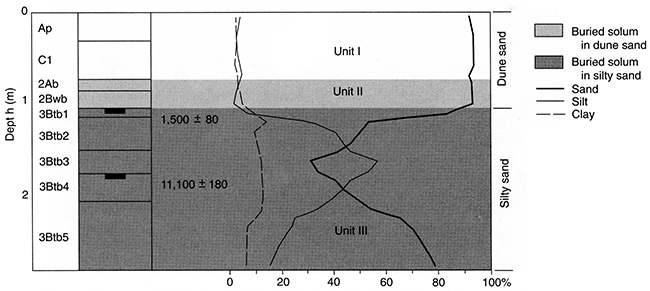
Stafford 11 is a 2.90-m (9.5-ft)-deep section (figs. 7, 46), exposed by backhoe trenching, in the SW SE sec. 6, T. 21 S., R. 11 W. Located in a compound subparabolic dune field (fig. 6), the site contains three, noncalcareous pedostratigraphic units: a lower one in silty sand overlain by two in massive, single-grained sand (figs. 46, 47). Deposits in the lower part of the profile are loamy, very poorly sorted, finely skewed and very leptokurtic to leptokurtic. In contrast, overlying sandy deposits are classified as sand, are poorly to moderately sorted, finely to very finely skewed, and very leptokurtic to leptokurtic (Arbogast, 1995). In general, the sedimentological differences between the silty sand (Unit III) and the dune sand (Units II and I) reflect the shift from moist conditions during the late Wisconsinan to more arid conditions in the Holocene. Unit III extends from 1.07 m to the base of the profile and is consistent in character with silty sand elsewhere (e.g., Edwards 1,2, and 4; Reno 4) in the study area. Two radiocarbon ages were derived from the deposit. One of approximately 11,000 yr B.P. from the center of the unit suggests late Wisconsinan deposition. The other, about 1,500 yr B.P. from the top of the stratum (figs. 46,47), implies exposure during the late Holocene. Based on δ13C values of about -16.0‰, C4 plants have dominated the site for the past 11,000 years.
Figure 45--Truncated surface at the top of Unit III at Stafford 10. Note the knife for scale. The nails identify the boundaries of sedimentary beds.
Unit III is also loamy, containing high percentages of silt (ca. 57%) and clay (ca. 14.5%). Very poorly sorted, the stratum contains a well-defined fining-upward sequence similar to those described at other localities in the region (e.g., Edwards 4, Reno 4, Stafford 3). Although no sedimentary structures were discerned, the nature of the unit suggests deposition in a fluvial environment of mixed energy.
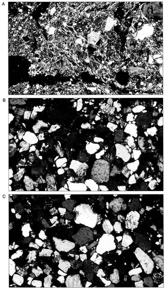
Following sedimentation, Unit III was evidently exposed and essentially stable for a very long period of time, and this promoted formation of a strongly developed buried soil consisting of five 3Btb horizons (fig. 47) with moderate to strong prismatic structure. In thin section, the matrix of the 3Btb3 horizon consists of skeleton grains of sand and silt surrounded by a clayey plasma. Mineralogy is dominated by quartz, but isolated grains of feldspar and rock fragments (e.g., biatite) are scattered throughout the section. The plasma is composed largely of striated clays, which indicate intensive illuviation of fine-grained material during pedogenesis. Clay skins are located primarily on the edge of sand grains, but they also line the inside of voids. Many of the sand grains are highly stained with iron, indicating oxidation. In addition, several sand grains are pitted, suggesting transport (fig. 48A).
Subsequent to development of the soil in Unit III, an erosional episode must have occurred, completely truncating the 3Ab horizon. Water tables must have been periodically high at this time, because the lower part of the 3Btb5 is slightly mottled.
Units II and I overlie Unit III with an apparent unconformity and sharp contact at 1.17 m (3.8 ft) (figs. 46, 47). Since they are similar in character, Units II and I can be grouped for purposes of discussion. Both, for example, contain over 90% sand that is poorly to moderately sorted (fig. 47). In addition, each contains a weakly developed soil with a mainly single-grain structure. Overall, they are consistent with dune sand in texture, sorting, structure, and topographic position and expression. In short, Units II and I reflect episodic sedimentation of eolian sand during a more arid climate than that in which Unit III was deposited. A radiocarbon age of about 1,500 yr B.P. from the top of Unit III (figs. 46, 47) provides a maximum-limiting, late Holocene age for wind-blown sand deposition. Following accumulation of Unit II, a brief period of landscape stability and soil formation occurred that resulted in development of a 2Ab and 2Bwb horizon (fig. 47). Although no radiocarbon age was obtained from this soil, it is similar in development and position with solums dated to less than I ,000 yr B.P. in the region (e.g., Crocket Cutbank, Reno 3 and 4, Stafford 2 and 6, Rice Roadcut). In thin section, the lack of pedogenic alteration in the 2Ab horizon is clear. The matrix consists primarily of skeleton grains of sand and, to a lesser extent, silt. Birefringent material surrounding the sand grains is probably clay. Although the presence of clay on sand grains implies illuviation, the clay could be present from previous weathering episodes and have been transported with the sand. Occasionally, sand grains are pitted and are lined with iron oxide. According to Ransom (personal communication, 1995), this evidence is inconsistent with the environment in which the grains are now found, further indicating transport. In addition, many of the grains are frosted (fig. 48B), which is consistent with eolian deposition.
Figure 46--The 2.90-m (9.5-ft)-high exposure at Stafford 11, showing the position of pedostratigraphic units and radiocarbon ages.
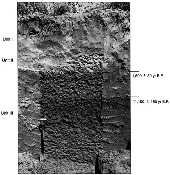
Figure 47--Pedostratigraphy, soil horizonation, and texture at Stafford 11.
Another period of deposition followed the development of the soil in Unit II, resulting in Unit I. Because Unit I is a very weakly developed surface soil, consisting of an Ap and C horizon (fig. 47), the site probably has been stable for a relatively brief period of time. Examination of the C horizon in thin section illustrates both the lack of post-depositional alteration of the sediments and verifies the brevity of the 2Ab. The matrix consists primarily of skeleton grains of sand and, to a lesser extent, silt. Quartz is the dominant mineral, although scattered grains of feldspar and rock fragments are present (fig. 48C). As in the 2Ab horizon in Unit II (fig. 48B), several of the grains are lined with clay. Given the single-grain structure of the horizon, this clearly suggests transport rather than illuviation of clay. Further evidence of transport lies in the many pitted grains covered with iron oxide and the frosting on many particles in the section (fig. 48C).
Figure 48--Thin sections (FOV = 1.85 x 2.69 mm) of (A) EBtb4, (B) 2Ab, and (C) C2 horizons at Stafford 11 (from Arbogast and Johnson, 1998).
Wilson Ridge
During the mapping phase of the project, a large anomalous dune was recognized in the west central part of the Great Bend Sand Prairie. The dune was unusual because of its size, relationship to other landforms, and orientation. Because of the potential for significant paleoenvironmental data that could supplement the entire study, detailed investigations were conducted and are presented below.
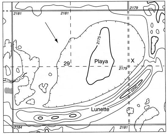
The site is located in the S2 secs. 28, 29, T. 25 S., R. 18 W. (figs. 6, 49) and was named Wilson Ridge after landowner Chad Wilson of Lewis, Kansas. In contrast to the majority of dunes in the study area, which are ≤100 m (328 ft) in length, Wilson Ridge is approximately 1.5 km (0.58 mi) long. In addition, the dune is concave in a northwesterly direction, rather than southwesterly as are other parabolic dunes in the region. When first discovered, the dune appeared to be related to a playa-lake basin immediately to the north (fig. 49). Preliminary investigations revealed a complex stratigraphy in the dune and a clear association with the playa. As a result, a hypothesis was formulated that the dune was a lunette, one that formed as sediment was deflated from the nearby lake bed during dry periods.
Figure 49--Topographic map in the vicinity of Wilson Ridge. Scale = 1:24,000 (Centerview 7.5-min. quadrangle, 1972). Pursuant to the landowner's request, the study transect was located where the unimproved road bisects the dune from north to south (x). The arrow reflects the direction of the prevailing winds that scoured the playa during arid intervals.
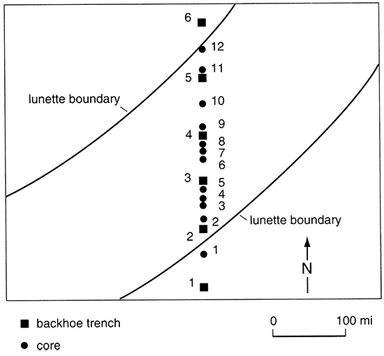
This lunette hypothesis was interesting because lunettes had not been formally recognized in the central Great Plains of Kansas and Nebraska. In fact, lunettes in the Great Plains had been previously identified only in the southern High Plains (Reeves, 1965, 1966; Holliday, 1985, 1989,1995). Of further significance, however, were the chronologie and paleoenvironmental ramifications of Wilson Ridge to the study as a whole. If indeed the feature was a lunette, then it must have formed when northerly or northwesterly winds prevailed in order to scour the adjacent playa and construct the dune. Northwesterly winds are thought to have last dominated during the late Wisconsinan (COHMAP Members, 1988; Kutzbach et al., 1993). Therefore, a final hypothesis was constructed, stating that Wilson Ridge was a lunette that formed during the Woodfordian when northwesterly winds prevailed. To test this theory, stratigraphic information was obtained from six backhoe trenches excavated along a south to north transect across the dune axis. In order to correlate stratigraphy among trenches, twelve cores were extracted with a Giddings coring machine (fig. 50).
Figure 50--Position of backhoe trenches and cores extracted from Wilson Ridge (modified from Arbogast, 1996a).
According to Arbogast (1996a), 10 late Quaternary stratigraphic units were identified through backhoe trenching and coring, and their chronology was established with 12 radiocarbon ages (table 3). Several, well-developed buried soils were recognized, at various positions in cross section (fig. 51), that formed in sediments ranging from clay loam to sandy loam (fig. 52).
Table 3--Radiocarbon ages obtained from Wilson Ridge. All ages were obtained on the base soluble fraction of total soil humates. 1 Calibration from a conventional δ13C-corrected radiocarbon age to calibrated calendar years using a tree-ring curve. All calibrations reported here were based upon the 20-year atmospheric curve (see Linick et al., 1985, 1986; Kromer et al., 1986; Mook, 1986; and Stuiver et al., 1986). Program used for calibration is discussed in Stuiver and Reimer (1993). 2Reported in Arbogast (l996a).
| Backhoe trench |
Depth (m) |
Laboratory number |
Uncorrected 14C age (yr B. P.) |
δ13C (‰) | Corrected 14C age (yr B.P.) |
Calibrated age1 (yr B. P.) |
|---|---|---|---|---|---|---|
| Trench 12 | 2.45-2.50 | Tx-8005 | 10,220 ± 200 | -18.3 | 10,330 ± 200 | 12,520 (12,200) 11,550 |
| Trench 22 | 1.18-1.23 | Tx-7827 | 5,490 ± 140 | -13.6 | 5,670 ± 140 | 6,640 (6,450) 6,310 |
| Trench 32 | 1.59-1.64 | Tx-7996 | 8,680 ± 180 | -14.2 | 8,860 ± 180 | 9,990 (9,890) 9,570 |
| Trench 32 | 2.65-2.70 | Tx-7826 | 10,180 ± 200 | -14.2 | 10,360 ± 200 | 12,550 (12,240) 11,670 |
| Trench 32 | 2.91-2.96 | Tx-8004 | 12,000 ± 220 | -18.1 | 12,110 ± 240 | 14,550 (14,130) 13,760 |
| Trench 42 | 2.60-2.65 | Tx-7825 | 16,330 ± 380 | -11.9 | 16,520 ± 400 | 20,070 (19,450) 18,960 |
| Trench 52 | 0.95-1.00 | Tx-8014 | 9,460 ± 180 | -13.0 | 9,840 ±180 | 11,660 (11,000) 10,870 |
| Trench 52 | 2.25-2.30 | Tx-7824 | 16,950 ± 460 | -11.9 | 17,180 ±480 | 21,137 (20,370) 19,611 |
| Trench 62 | 0.73-0.78 | Tx-8002 | 2,600 ± 100 | -12.4 | 2,800 ± 100 | 3,020 (2,870) 2,770 |
| Trench 62 | 1.13-1.18 | Tx-7695 | 3,220 ± 80 | -13.2 | 3,410 ± 80 | 3,822 (3,677) 3,478 |
| Trench 62 | 1.94-1.99 | Tx-7997 | 7,410 ± 160 | -15.6 | 7,560 ± 160 | 8,440 (8,340) 8,130 |
| Trench 62 | 3.58-3.63 | Tx-7995 | 17,480 ± 520 | -20.8 | 17,540 ± 260 | 21,620 (20,880) 20,070 |
Figure 51--Cross section showing the position of stratigraphic units, trenches, and cores at Wilson Ridge (modified from Arbogast, 1996a).
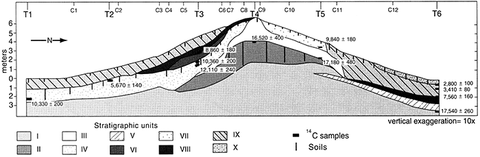
Figure 52--Trench and soil stratigraphy, including radiocarbon ages, at Wilson Ridge (modified from Arbogast, 1996a).
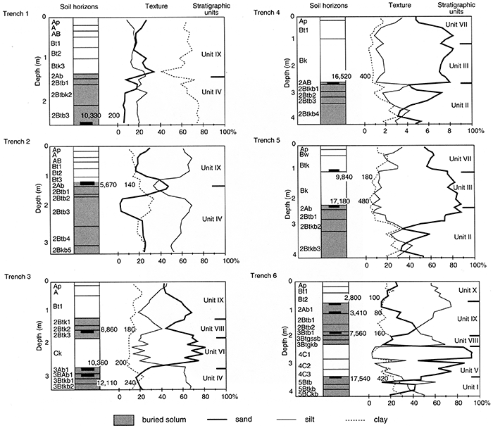
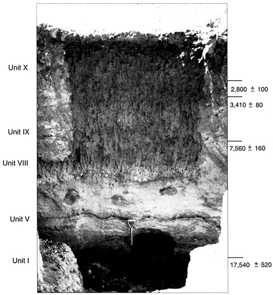
The basal unit (Unit I), which was recognized in trench 6 (fig. 53) and cores 2 to 4, 6 to 9, and 11 (figs. 51-52), underlies the lunette where it is about 3 m (9.8 ft) higher than in the playa. The unit consists of gleyed silt and clay containing fragmented gastropods. Humates at the top of Unit I in trench 6 dated to about 17,500 yr B.P. and provided a δ13C value of -20.8‰.
Figure 53--Trench 6, 4.20 m (13.78 ft) deep, at Wilson Ridge showing stratigraphic units and radiocarbon ages.
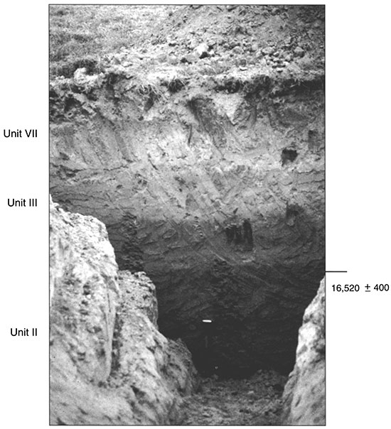
Unit II was recognized in trenches 4 (figs. 51-53) and 5 (figs. 52, 54), as well as in cores 7 to 10. The unit contains numerous gastropod fragments and is extremely calcareous; it is thickest (ca. 2 m; 6.6 ft) in the center of the dune, but pinches out or is truncated both up and downslope (fig. 51). Formed throughout the deposit is a well-developed buried soil, consisting of several Btb horizons. Humates in the upper part of Unit II dated to about 16,500 yr B.P. in trench 4 and approximately 17,200 yr B.P. in trench 5 (figs. 52, 55). In addition, δ13C values of -11.9‰ were obtained from both samples.
Figure 54--Trench 5, 4.18 m (13.71 ft) deep, at Wilson Ridge showing stratigraphic units and radiocarbon ages.
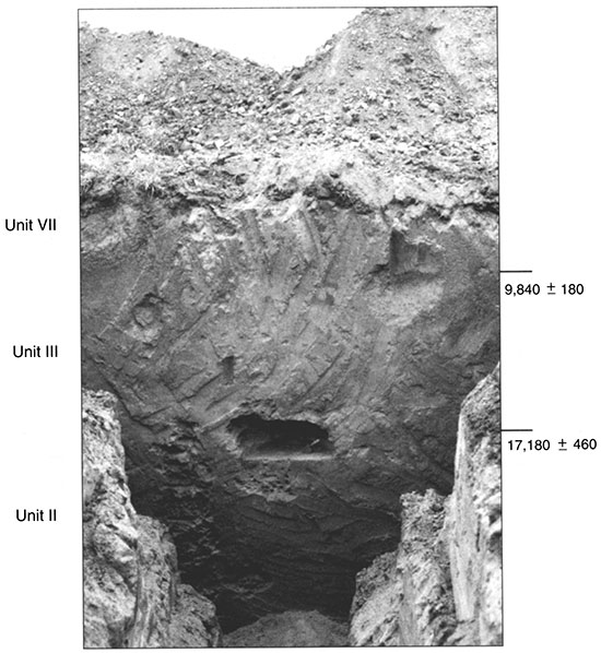
Figure 55--Trench 4, 4.22 m (13.85 ft) deep, at Wilson Ridge showing stratigraphic units and radiocarbon age.
Unit III consists of calcareous, sandy sediments, containing fragmented gastropods, and overlies Unit II in the center and north slope of the dune. The deposit, which has a maximum thickness of about 2.6 m (8.5 ft), was recognized in trenches 4 (figs. 51, 52, 55) and 5 (figs. 52, 54) as well as in cores 6 to 11. It appears to have been truncated on both the north and south slopes (fig. 51). Although no radiocarbon ages were obtained directly from Unit III, ages of approximately 17,200 and 9,800 yr B.P. obtained from trench 4 (figs. 52, 55) effectively bracket the deposit.
Capping Units I, II, and III is Unit IV, which is recognized in trenches 1 through 3 (figs. 56-58) and in cores 1 through 8. Unit IV consists of pale-brown (10YR6/3; moist) silt and has a maximum thickness of about 1.4 m (4.6 ft). Inset against Unit III in the center of the dune, Unit IV overlies Unit I on the south slope. The stratum contains a well-developed soil recognized in most of the dune's south slope that merges with the surface soil at the dune crest (fig. 51). Humates in the upper part of the 3Ab in trench 3 dated to about 12,100 yr B.P. and provided a δ13C value of -18.1‰.
Figure 56--Trench 1, 3.31 m (10.86 ft) deep, at Wilson Ridge showing stratigraphic units and radiocarbon age.
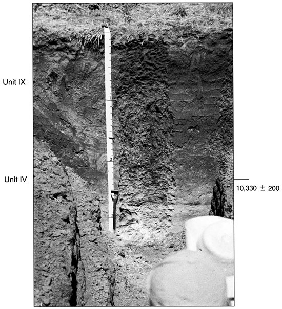
Figure 57--Trench 2, 3.22 m (10.56 ft) deep, at Wilson Ridge showing stratigraphic units and radiocarbon age.
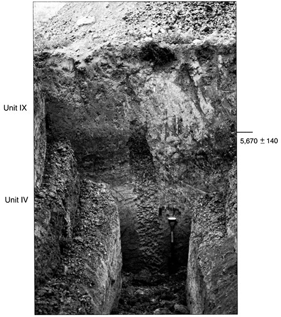
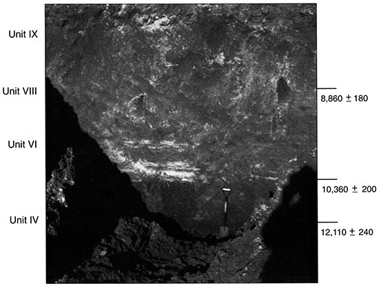
Figure 58--Trench 3, 3.24 m (10.63 ft) deep, at Wilson Ridge showing stratigraphic units and radiocarbon ages.
Unit V includes laminated deposits of sand and silt (fig. 51) recognized in the playa in trench 6 (fig. 53) and in cores 11 and 12 on the dune's north slope. The maximum thickness of the unit is about 1.5 m (4.9 ft) (fig. 51). Although no radiocarbon age was derived from the stratum, ages of about 17,500 and 7,600 yr B.P. in trench 6 (figs. 52, 53) bracket the deposit.
Unit VI is a lens of laminated silt and sand that was identified on the south flank of the dune in trench 3 (figs. 52, 58) and in cores 4 to 6. In trench 3 the deposit is about 1.4 m (4.6 ft) thick, but it thins both up and downslope (fig. 51). Sedimentary structures (e.g., small cross-beds, convolutions) suggest that the sediment was saturated when it accumulated, possibly related to slumping (fig. 59). Many of the laminae are consistent in character (e.g., texture, color) with the underlying soil, suggesting it may have been a source for sediment. An age of about 10,400 yr B.P. (δ13C value: -14.2‰) from the upper part of the 3Ab in trench 3 is a maximum-limiting age for Unit VI, and an age of about 8,900 yr B.P. (δ13C value: -14.2‰) from the lower part of the overlying 2Btk3 gives the minimum-limiting age (figs. 51, 58). These ages, coupled with the character of the deposit, further suggest rapid accumulation. Given this scenario, Unit VI separates two buried soils in trench 3 that are otherwise welded upslope at the surface in cores 7 and 8 and downslope in trenches 1 and 2 and core 1.
Figure 59--Sedimentary structures, including laminations and load structures, in Unit VI in Trench 3 at Wilson Ridge.
Unit VII, a lens of sandy silt and sand, mantles Unit III on the upper north slope of the dune (fig. 51). Observed in trench 5 (figs. 52, 55) and cores 9 and 10 (fig. 51), it is similar to the underlying Unit III, but does not contain gastropods. As a result, it may indicate a different depositional interval. Humates from the lower part of the Btk horizon of Unit VII in trench 5 dated to about 9,800 yr B.P. and provided a δ13C value of -13.0‰.
Unit VIII is a thin veneer of silty sediment on the north slope of the dune in trench 6 and core 12 (figs. 52, 53) and on the south slope of the dune in trench 3 and cores 3 to 7 (fig. 51, 58). In the playa, the deposit is about 42-cm (16.5-in)thick where it overlies Unit V. Humates from the upper part of the 3Btb1 horizon in trench 6 provide a minumum-limiting age of around 7,600 yr B.P. and a δ13C value of -15.6‰. The age of the unit can be better estimated on the south slope of the dune, where it is about 1.5 m (4.9 ft) thick, is capped by a truncated buried soil, and overlies the stratified deposits of Unit VI. Radiocarbon ages of about 8,900 yr B.P. (δ13C value: -14.2‰) at the base of the deposit in trench 3 (figs. 51, 58), and approximately 5,700 yr B.P. (δ13C value, -13.6‰) from the upper 2Ab in trench 2 (fig. 51,57) provide maximum- and minimum-limiting ages, respectively, for Unit VIII on the south slope of Wilson Ridge.
Unit IX is a deposit of silty sediment on both the north and south flanks of the dune (figs. 51, 52). On the north side, the unit was recognized in trench 6 (figs. 52, 53) and cores 11 and 12 (figs. 51). The deposit is thickest (1.21 m; 3.9 ft) in trench 6, where it is bracketed by radiocarbon ages of about 7,600 and 3,400 yr B.P. On the south side of the dune, the stratum was recognized in trenches 1 to 3 and cores 1 to 6 where it has an average thickness of about 1.2 m (3.9 ft) (figs. 51, 52). A radiocarbon age of approximately 5,700 yr B.P. was derived from the 2Ab in trench 2 (figs. 52, 57) and provides a maximum-limiting age for Unit IX on the south side of the dune.
Unit X is a thin veneer of sediment, positively identified in the playa within trench 6 (figs. 52, 53). The unit is a 73-cm (28.7-in)-thick deposit of silt (fig. 52) that buried a well-developed soil soon after 2,800 yr B.P. Unit X may thinly mantle most of the dune, however, as suggested by the textural and pedogenic consistency (i.e., thermic, pachic Argiustoll) that is present, except for the north slope (Arbogast, 1996a).
In summary, the stratigraphic and chronologie evidence indicate a complex late Quaternary history at Wilson Ridge (Arbogast, 1996a). Ten stratigraphic units, containing a total of six buried soils, are present and represent a variety of depositional events and facies. Based on the unique characteristics (e.g., sedimentology, radiocarbon ages) of each unit, the geomorphic history can be reconstructed (Arbogast, 1996a). In addition, radiocarbon-derived δ13C values (Krishnamurthy et al., 1982) and faunal remains can be used to infer paleoclimatic variability through time.
From the data currently available, it is impossible to precisely determine when Wilson Ridge began to develop. As with other lunettes in the Great Plains (e.g., Reeves, 1965; Holliday, 1985, 1989), the dune is closely associated with an adjacent playa (fig. 49). The underlying deposit (Unit I; fig. 51) is consistent with other late Wisconsinan deposits on the Great Bend Sand Prairie (e.g., Edwards 1-4, Reno 4). A radiocarbon age of about 17,000 yr B.P. from a buried soil in Unit I provides an estimated minimum age for the deposit. According to Arbogast (1996a), this correlates reasonably well with studies conducted elsewhere in the Great Plains. Holliday (1985), for example, presented evidence that lunettes began to form in the southern High Plains around 30,000 yr B.P. In addition, Reeves (1965) obtained a radiocarbon age of approximately 19,000 yr B.P. directly beneath a lunette in Texas. Given that Wilson Ridge overlies a unit that is texturally and chronologically consistent to the one described by Reeves (1965), eolian sedimentation probably began at Wilson Ridge about 20,000 yr B.P. This age estimate also correlates with the onset of Peoria loess sedimentation in the central Great Plains (Wells and Stewart, 1987; Johnson et al., 1993). Eolian deposition at Wilson Ridge apparently began because the playa was deflated and Unit II accumulated downwind of a small ridge or shoreline formed in Unit I.
From the available evidence it appears that deposition of Unit II continued, as a result of prevailing northwesterly winds, until approximately 17,000 yr B.P. The sediment is calcareous and includes numerous gastropod fragments that were probably transported from the playa. Following this interval of sedimentation, the playa stabilized, resulting in a well-developed soil in both the lake bed and on the dune. Values of δ13C suggest vegetation edaphically varied during this interval of time: -20.9‰ from the playa indicates a higher proportion of C3 plants, whereas -11.9‰ demonstrates that the well-drained dune was xeric.
Soon after the episode of stability of 17,000 yr B.P., another interval of eolian sedimentation transpired. According to Arbogast (1996a), this period of deposition lasted until around 12,000 yr B.P., largely occurred in two stages, and may have been driven by the climate changes associated with the major late Wisconsinan deglaciation (Ruddiman, 1987). The initial stage resulted in Unit III, a deposit of calcareous and sandy sediment on the north slope and crest of the dune that deflated from the playa. The latter interval is represented by Unit IV, which accumulated on the south slope of the dune. Unit IV is similar in texture (70% silt) and color (10YR6/3; moist) to Peoria loess, a unit of late- Wisconsinan loess (Wells and Stewart, 1987; Johnson, 1993, Johnson et al., 1993) that has been recognized immediately to the north and south of the Great Bend Sand Prairie (Feng, 1991; Feng et al., 1994). As a result of this similarity to Peoria loess, it is conceivable that Unit IV may have originated from a distant source.
Subsequent to the deposition of Units III and IV, a well-developed soil formed in Unit IV on the upper part of the dune's south slope (fig. 51). Radiocarbon ages from the lower and upper boundaries of the soil suggest that landscape stability may have lasted for approximately two thousand years (i.e., from about 12,000 to 10,000 yr B.P.). This interval of pedogenesis implies a temporal correlation with the Brady soil, a geosol that represents a major period of landscape stability in the central Great Plains (Schultz and Stout, 1948; Frye and Leonard, 1951; Caspall, 1970, 1972; Feng et al., 1994) at the Pleistocene-Holocene climatic boundary (Johnson and May, 1992). Generally, the interval of time represented by the Brady geosol is thought to range from approximately 10,500 to 8,500 yr B.P. The vast majority of ages derived from the Brady, however, are from northern Kansas (e.g., Johnson, 1993) and Nebraska (e.g., Johnson and May, 1992; Johnson et al., 1993). According to Arbogast (1996a), the results from Wilson Ridge suggest that the Brady may be time-transgressive.
Given that the soil (Brady") in Unit IV is so well developed, it is interesting that it occurs only on the south slope of the dune. This spatial variability may have occurred for one of two reasons: (I) a soil formed only on the lee slope of the dune because strong northwesterly winds perpetually destabilized the north slope; or (2) a soil initially formed over the entire dune, but was truncated on the north slope during the early Holocene.
According to Arbogast (1996a), four variables suggest that the north slope of the dune was extensively eroded during the early Holocene: (1) the soil on the south slope is extremely well developed, suggesting a major period of landscape stability; (2) the preserved soil dips more steeply than the modern surface (moreover, it merges with the surface soil on the crest, suggesting the dune was higher at one time with the soil continuing to the north slope); (3) values of δ13C shift from -18.1‰ in the lower boundary to -14.2‰ in the upper boundary of the soil on the south slope of the dune, which suggests a shift to a more arid and potentially unstable environment towards the end of the soil-forming interval; and (4) the soil was partially truncated on the lower part of the lee slope of the dune.
The nature of early Holocene deposits suggests that a significant period of landscape instability occurred soon after about 10,000 yr B.P., resulting in complete truncation of the Brady soil on the north slope and its partial truncation on the south slope. Specifically, the position and sedimentology of Unit VI (fig. 51) imply at least one major erosional event in the early Holocene. As mentioned previously, Unit V consists of well-laminated deposits of sand and silt, containing convolutions and load structures, that buried the soil in Unit IV. A radiocarbon age of approximately 8,900 yr B.P. was obtained from sediments directly above Unit VI. Coupled with the maximum-limiting age of about 10,000 yr B.P. (from the top of Unit IV), this provides a relatively narrow window (-1,000 yr) for the deposition of Unit VI to have occurred. Overall, the width of the depositional interval and the deposit's sedimentology indicate rapid accumulation. Stringers of organic-rich laminae in the unit, apparently derived from the underlying soil, suggest that mass wasting of upslope sediment truncated the soil near the crest of the dune. As a result, the dune probably decreased in height and the position of the crest shifted slightly from north to south.
During the Holocene the geomorphic chronology is characterized by episodic deposition in a periodically more arid, destabilizing environment. Evidence suggests that the playa remained the sediment source during the early Holocene. A major unconformity exists between units V and VIII, suggesting that strong, northwesterly winds deflated the lake bed. As a result, the north slope and crest of the dune would have frequently been destabilized, whereas the southern slope was protected. Accumulation of sandy sediment (Unit VII) began approximately 9,000 yr B.P. on the north slope of the dune. The onset of this sedimentary interval correlates with events recorded elsewhere in the region, including deposition of Bignell loess (Frye et al., 1968; Feng, 1991; Johnson, 1993) and localized eolian erosion in the southern High Plains (Holliday, 1989). A δ13C value of -13.0‰ from Unit VII suggests increased aridity at the site during the early Holocene. In addition, the unit lacks the gastropods that are contained in underlying deposits, further suggesting increased aridity. Early Holocene deposition on the north slope was probably episodic because a well-developed soil formed in the playa around 7,500 yr B.P. This period of stability correlates reasonably well with soil formation in a playa located to the west in Haskell County (Mandel and Olson, 1995).
Despite the instability of the north slope, evidence suggests that the south slope was largely in equilibrium during the early Holocene. Other than deposition of Unit VI and some erosion of the Brady soil, extended pedogenesis prevailed. On the upper part of the south slope, a period of soil formation began soon after deposition of Unit VI. This period of stability lasted until about 5,800 yr B.P. Immediately south of the dune, an extended period of pedogenesis (-10,300-5,800 yr B.P) resulted in the development of a thick, cumulic soil.
It is surprising that the south slope of Wilson Ridge was stable throughout the early Holocene while the north slope was severely truncated, especially since regional and local evidence implies a more unstable environment. Documented early Holocene climate change (Webb, 1985; Crowley and North, 1991) reflects a gradual temperature increase, which culminated in the middle Holocene as an extended warm, dry period (Wright, 1970; Benedict and Olson, 1978; Barry, 1983; Holliday, 1989). This period is commonly referred to as the Altithermal (Antevs, 1955). Values of δ13C, derived from the buried soil on the south side of Wilson Ridge (fig. 51), reflect the regional record, changing from -18.3‰ at about 10,300 yr B.P. to -13.6‰ around 5,800 yr B.P. Given the overwhelming evidence for a shift to more arid conditions, the south slope of Wilson Ridge should have destabilized in the early Holocene. According to Arbogast (1996a), the only logical explanation is that mobilizing winds remained northwesterly into the latter part of the early Holocene, resulting in a "windshadow" that protected the south slope.
According to Arbogast (1996a), Wilson Ridge has generally been a stable landform in the past 5,000 yr B.P. Local climate has generally remained warm and dry, as indicated by low δ13C values (e.g., -12.4‰). Sedimentation in the playa (Unit IX) has been episodic with soil formation occurring between about 3,500 yr B.P. and 2,800 yr B.P. This pattern correlates to a period of relative stability, one that began around 4,000 yr B.P., in a playa in Haskell County (Mandel and Olson, 1995). On the south slope of the dune, an approximately 1-m-thick deposit of sandy silt (Unit IX) has accumulated in the past 5,000-6,000 years. This corresponds to the record derived from a lunette in the Sandhills of Texas, where eolian sedimentation occurred between about 6,000 yr B.P. and 4,500 yr B.P. (Holliday, 1989). In contrast to earlier deposits, which were mobilized by northwesterly winds at Wilson Ridge, sedimentation on the south slope (Unit IX; fig. 51) apparently resulted from the same southerly winds that were documented by Arbogast (1996b) elsewhere on the Great Bend Sand Prairie in the late Holocene. At most localities across the dune and playa, the surface soil is well developed, indicating relatively long-term (ca. 1,000 yr) stability at the site. The lone exception is on the upper north slope where the surface soil is less well developed, suggesting that this area of the dune has recently been active and that northwestly winds continue to provide sediment (Arbogast, 1996a).
Prev Page--Results, Start || Next Page--Discussion and Conclusions
Kansas Geological Survey, Geology
Placed on web March 16, 2016; originally published 1998.
Comments to webadmin@kgs.ku.edu
The URL for this page is http://www.kgs.ku.edu/Publications/Bulletins/242/04_results2.html