![]()
Gorham Oil Field, Russell County, Kansas
by Robert F. Walters
Originally published in 1991 as Kansas Geological Survey Bulletin 228. This is, in general, the original text as published. The information has not been updated. An Acrobat PDF version (44 MB) is also available.
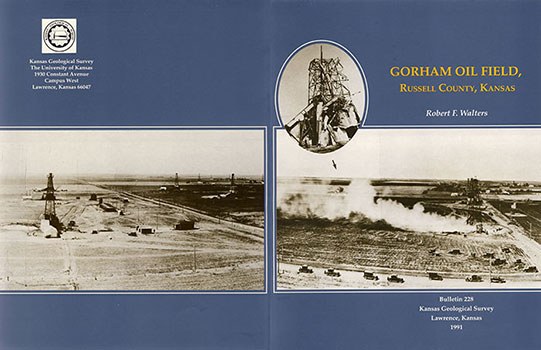
Front cover--Gorham oil field, April 14, 1928; view west toward the Gorham town site. Steam is rising from Day Petroleum Company's Joe Mermis No. 2, where rigging-up operations are underway. Photographed by E. J. Banks from the derrick of Johnson and Vickers Gorham #1 in sec. 33, T. 13 S., R. 15 W.; courtesy of Russell County Historical Society. Arrow points to the Joe Mermis No. 4 with collapsed derrick (inset). See pages 56-57. Back cover--Gorham oil field, April 14, 1928, continued from the front cover. View is to the southwest.
Foreword
In conversations and correspondence during 1982, Robert F. Walters and I agreed that the Kansas Geological Survey would publish his monograph on the Gorham oil field of Russell County, Kansas. Additionally, the Survey would provide necessary clerical, graphical, and editorial assistance. Several reasons motivated this decision to publish the work of a professional industry geologist having no occupational ties with the Kansas Geological Survey. The first relates to his unsurpassed knowledge of the Gorham field and its prominent position in the petroleum development of central Kansas, knowledge gained through experience and long, intense, and enthusiastic study. A second reason relates to his rare historical sensitivity that sets this work apart from the usual case study of the development of a significant oil field. Lastly, I much admired his personal qualities, such as professional integrity, scholarly breadth of interest, and willingness to share his skills and insights with others.
In elaboration of the first reason, one might say that this volume on the geology and historical development of the Gorham oil field by Robert F. Walters reflects a love affair with central Kansas and the Central Kansas uplift of some 40 years duration. As Barbara W. Tuchman has observed in Practicing History, " . . . it is this quality of being in love with your subject that is indispensable for writing good history-or good anything, for that matter." It would seem, in a way, that his entire career has been pointed toward this volume. Dr. Walters gained his Ph.D. degree in geology from Johns Hopkins University in 1946, based partly on his dissertation on "Buried Precambrian hills in northeastern Barton County, central Kansas," a pioneering effort begun while he was a research geologist with Gulf Oil Corporation in Tulsa, Oklahoma. He discovered a thread of continuity, the movement of fluid through soluble rocks, that guided much of his later effort, and through his insoluble residue work documented a buried karst or paleokarst between buried Precambrian hills. Subsequent work and publication had to do with migration of oil and gas, production from fractured Precambrian basement rocks, subdivision into mappable units and differential entrapment in the Arbuckle dolomite, and salt dissolution and land subsidence. The Gorham oil field exhibits aspects of all these important subjects and is representative of the exciting development of the giant oil fields of central Kansas. Furthermore, with diligence, its record and history were recoverable by someone who cared.
As to the second reason, the work gives historical perspective to the methods used to develop the field by discussing exploration, drilling, and production techniques, and even the behavior of field geologists. It draws upon personal experience, anecdotes and records of friends and colleagues, and museum and library records. It helps to explain the evolution of institutions and practices that survive in Kansas to the present. In like manner, it examines the environmental impact of the field's development. This integration of geology, history, and environment causes this volume to be unique as a synthesis of the geologic conditions that led to the field's development, and the environmental conditions that development engendered.
Finally, Bob Walters has a long record of exemplary service to his profession and consulting in the public interest. This was recognized by his election in 1987 as an Honorary Member of the American Association of Petroleum Geologists. With respect to the Kansas Geological Survey, review of correspondence shows his first appointment to the Geological Survey Advisory Council (then called the Mineral Industries Advisory Council) by Chancellor W. Clarke Wescoe in 1963. He continued in this role for 10 years, serving five years as Council chair. In this capacity, he provided leadership in recommending new programs and stimulating staff discussions about old ones, securing funding for the construction of Moore Hall, and in recommending to the Chancellor appropriate personnel policies for the staff of the Geological Survey.
During the early 1970's, the Kansas Geological Survey was much involved in the problems of storing high-level nuclear waste at Lyons, Kansas. An independent consultant on drilling, coring, logging salt beds, borehole plugging, subsidence, and field operations in the midcontinent was badly needed by Union Carbide Corporation-Nuclear Division, the contractor for the Atomic Energy Commission. I could think of no better qualified person than Bob Walters, who had owned and operated oil wells, saltwater-disposal wells, and rotary-drilling tools for more than 20 years. I recommended him for the assignment. Somewhat reluctantly, he accepted the challenge, but only after his term on the Advisory Council had ended. He continued to provide valuable guidance on these matters until 1982 to successor agencies and their contractors, including the Energy Research and Development Agency, Department of Energy, and Battelle Memorial Institute.
The report by Walters in 1976 to the Solution Mining Research Institute on subsidence in Kansas caused by salt dissolution was a model of clarity on cause and effect. Because of its limited distribution, we suggested release for publication. Release having been granted, the report emerged as "Land subsidence in central Kansas related to salt dissolution," Kansas Geological Survey Bulletin 214, published in 1978, and Bob Walters had become a Geological Survey author. This volume was reprinted in 1984, an indication of its impact and popularity. Having influenced this oil finder in a new direction of public service, when the matter of publication of the Gorham oil field seemed certain I could do no less than recommend to the Chancellor in 1987 that Dr. Walters be appointed Adjunct Senior Scientist. This title conveys certain responsibilities and perquisites, but not included are salary or other compensation. It is satisfying to be associated again with Robert F. Walters in a unique publication venture, especially one that will help to preserve an important part of exploration and environmental history in Kansas.
William W. Hambleton
Emeritus Director
1990
Abstract
The 1,397 oil wells in the Gorham oil field have produced nearly 100 million barrels of oil (BO) from 1926 to 1986. Wells were drilled on 10-acre (4-hectare) spacing 660 ft (198 m) apart, within the 50 mi2 (130 km2) oil field. The Arbuckle dolomite (Cambrian-Ordovician) and Reagan Sandstone (Cambrian), a unit reservoir with a strong water drive (original oil-water contact near subsea -1,440 ft), has produced 66% of the oil from porosity under the Pennsylvanian unconformity surface near 3,300 ft (9.90 m). The Lansing-Kansas City (Pennsylvanian) limestone reservoirs have produced 25% of the oil from structural and porosity traps by primary dissolved gas drive and secondary water flooding. A fracture zone in the Topeka limestones (Pennsylvanian) provided the reservoir(s) for spectacular oil recovery of 200,000 BO per well from 30 oil wells. A fourth pay zone yielded gassy, stratigraphically trapped oil from the Tarkio (Pennsylvanian) after fracturing. Precambrian granite and quartzite yield small amounts of oil in 15 wells.
The Gorham oil field is localized by a 10-mi (16-km)-long northwest-trending anticline with 400 ft (120 m) of faulting in the Precambrian granite on the southwest flank. Fault relief diminishes upward with 30 ft (9 m) of closure present in the near-surface Fence-post limestone (Cretaceous). The anticline was defined by the then-unique method of core drilling which provided the location for the discovery well in 1926.
In the 1920's, 1930's, and early 1940's, holes were drilled by the now-obsolete method of cable-tool drilling, providing excellent samples of well cuttings used by the author for acid insoluble residue studies, permitting subdivision of the Arbuckle dolomites into six mapped units. The drilling and development history and the changing role of the petroleum geologist are reviewed with illustrations of cable-tool rigs, derricks, and historic maps.
The adverse environmental effects of.this 60-year-old oil field (444 remaining active oil wells, December 31, 1986) include saline contamination of formerly useful freshwater aquifers and of limited agricultural areas plus slow, long-continued, costly subsidence affecting Interstate Highway 70 (I-70) in three areas. Subsidence rates are diminishing to only one-half foot per year, maximum, in 1986. Subsidence is caused by inadvertent dissolution of the Wellington salt (Permian) at depths of 1,300-1,550 ft (390-465 m) by improperly disposed waste oil-field brines that were unsaturated with regard to salt (halite, NaCl). Stringent regulation by the Kansas Corporation Commission of brine disposal and plugging of abandoned wells is minimizing additional adverse environmental impact.
Kansas Geological Survey, Geology
Placed on web Jan. 30, 2015; originally published 1991.
Comments to webadmin@kgs.ku.edu
The URL for this page is http://www.kgs.ku.edu/Publications/Bulletins/228/index.html