
|
Original published in D.F. Merriam, ed., 1964, Symposium on cyclic sedimentation: Kansas Geological Survey, Bulletin 169, pp. 593-605 | |
University of Illinois, Urbana, Illinois
Environmental maps of the Midwest area indicate that within a single widespread cyclothem, clastic wedges may reach the sedimentary basin from three or four different directions. Their stratigraphic positions and directions of source of sediment provide excellent clues to the time and place of contemporary tectonism. Widespread cyclothemic successions may become indistinguishable where traced away from sources of clastic wedges toward a marine environment where the marine limestones of several separate transgressions may merge into a single limestone. It is proposed that the megacyclothem of the northern Midcontinent is equivalent to a single cyclothem of the Illinois type, rather than a number of these as has been suggested.
Later, when studies were extended into the southern and eastern borders of the Illinois Basin, the eastern Midcontinent, and the Appalachian Coal Field (Wanless, 1939, 1946, 1962), it became evident that: (1) the cyclic pattern varies greatly from place to place (Wanless, 1947) and from time to time at the same place, (2) in some regions there is a greater degree of variability and there are fewer thin widely persistent units, and (3) a certain stratigraphic interval is not everywhere represented by the same, or even the same number of cyclic successions throughout a large region.
This paper is written to present evidence of and to give interpretation for the variability in the number of cyclic successions in the Appalachian, Illinois, and Midcontinent Coal Basins. It is also concerned with the problem of classification in the cyclothemic framework of variable numbers of successions of a cyclic nature. The paper also deals with the relations between cyclothem sequences as developed in Illinois and the more complex megacyclothems of the northern Midcontinent.
Acknowledgments--Many of the examples cited in the paper are derived from environmental mapping studies done under the author's direction of the Brereton cyclothem, by John B. Tubb, Jr., of the Liverpool cyclothem by Cynthia Roseman, of the Summum cyclothem by John Weiner, and of the Sparland cyclothem by Constantine Manos. Interpretations frequently arose from fruitful discussions with these persons. Aid in preparation of illustrations has been supplied by the Department of Geology, University of Illinois; David A. Waltrip drafted the illustrations. The manuscript has been critically read by H. B. Willman, J. A. Simon, J. Baroffio, J. B. Tubb, Jr., Cynthia Roseman, and Julie Rystrom.
Because the deposits just described fit well into a general cyclothemic pattern, it has also become evident that other clastic wedges may appear during the formation of a widespread coal, limestone, or black shale. Where this has taken place, the persistent units may be spread so far apart that they may appear to belong to different cyclic successions. Indeed, in association with the wedge of shale and sandstone there may be locally a coal and limestone added to the new sequence, so as to simulate a full-fledged cyclothem. The author has made several errors in earlier correlations through failure to recognize the insertion of these local cyclic units into the more widespread layer-cake successions of cyclothems with which he was already familiar. It is now evident that several of the studied cyclothems contain as many as three or four clastic wedges in addition to the ones including their basal and topmost beds. Should the strata associated with each such wedge be designated a cyclothem, where present, to be combined into a single cyclothem at their distal margins? Or, should the definition of a cyclothem be modified so that it applies only to cyclic successions with great regional extent, considering the local clastic wedges as stray members or sequences? If the latter is done, a cyclothem may have three or four coals and similar numbers of other lithologic types in one area and only one of each in a location beyond the distal margins of the clastic wedges.
In many places at the distal margin of a clastic wedge, the wedge is reduced to a bedding plane or occasionally a very thin unusual layer such as the Covel Conglomerate (Willman, 1939), suggesting that numerous other abrupt lithologic changes at bedding planes may mark nondepositional intervals.
The megacyclothem of the northern Midcontinent (Moore, 1931, 1950) has been considered to be a sequence of cyclothems of unlike character in Illinois (Weller, 1958). Its distinctive features are three unlike marine limestones, and locally one or two others, separated by characteristic types of argillaceous sediment. The most distinctive part of the sequence is a black fissile shale a few feet thick grading up through several feet of gray shale into the principal marine limestone, the third limestone from the base. This black fissile shale is underlain with knife edge contact by a single bed of marine limestone, generally less than 18 inches thick which in turn rests on poorly bedded gray shale. The author suggests that this limestone may be wholly or in part the marine correlative of a coal bed, for in many areas the coals of the Pennsylvanian are immediately overlain by entirely similar black shale and underlain by poorly bedded gray claystone, the underclay of a coal bed. The lower of the three principal marine limestones may be equivalent to the underclay limestone of the Illinois Basin, generally nodular, algal and nonmarine, but also in some places carrying a marine fauna. In such a case a megacycle, at least the three lower limestones and associated shales, would be equivalent to one, rather than a succession of cyclothems of Illinois type.
The Cedar Grove coal of West Virginia, of Kanawha age, is a 6-foot 9-inch coal near Holden, Logan County, where it contains a 6-inch parting of clay 4 feet above the base (Hennen and Reger, 1914, p. 171-175). Within the same county the clay parting expands quite abruptly to a massive gray ledge of sandstone up to 60 feet thick. Where this wedge intervenes, the Cedar Grove coal is considered two separate beds, the upper and lower Cedar Grove, separated by the middle Cedar Grove Sandstone. This sandstone is prominent in southeastern Logan and Mingo Counties, but absent in the northwestern portions of the two counties. Therefore, it appears to be a clastic wedge thickening to the southeast. Figure 1 shows a generalized cross section of this wedge.
Figure 1--Wedge of sandstone dividing Cedar Grove coal into two beds, Logan County, West Virginia.
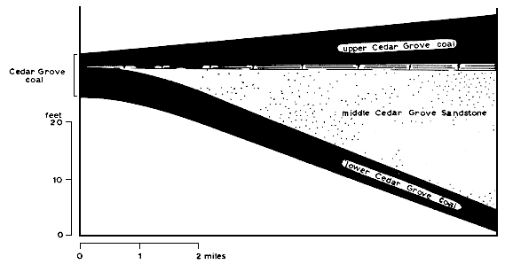
Figure 2--Clastic wedge dividing Kellioka coal southeast of Lynch, Harlan County, Kentucky.
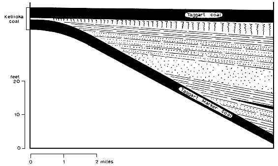
Figure 3--Clastic wedge of Englevale Sandstone and associated strata dividing Lexington coal in western Missouri (adapted from Searight, 1959, pl. 2).
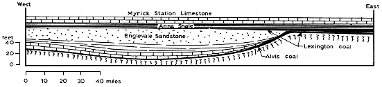
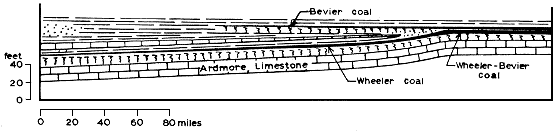
Figure 4--Clastic wedge separating Bevier and Wheeler coals in western Missouri (adapted from Searight, 1959, pl. 2).
The division of coals by these clastic wedges would not indicate the division of a cyclothem into two, except as additional clays, shales or limestones are found in the wedge interval.
Brereton Cyclothem
The Brereton cyclothem is represented by a cross section from Missouri across Illinois to Indiana (Fig. 5). The cross section shows that the cycle is initiated by a delta complex spreading southwestward from west-central Indiana into southern Illinois. This is followed by deposition of a coal (Illinois No. 5a) on the higher part of the delta, while no sediment formed in much of northern Illinois, and marine waters occupied much of Missouri and Iowa. At the close of coal accumulation the sea transgressed from Missouri to southern Illinois, slightly overlapping the No. 5a coal. The transgression was followed by the formation of another clastic wedge, a shale and sandstone delta complex similar in distribution to that below the No. 5a coal in southern Illinois and western Kentucky. This transgression, however, was followed by general marine regression both in Illinois, Missouri, and Iowa, so that the succeeding coal (No. 11 in Kentucky, No. 6 in Illinois, Mystic in Iowa, and Lexington of eastern Missouri) accumulated through large parts of the area and is the only coal in the western Illinois area where the cyclothem was named.
Figure 5--Idealized cross section showing clastic wedges within Brereton cyclothem and its correlatives (not to scale): (A) Vermilionville Sandstone equivalent, southern Illinois Basin, (B) Vermilionville Sandstone of northern Illinois (not shown), (C) sandstone between coals 5a and 6, southern Illinois Basin, (D) Englevale Sandstone between Lexington and Alvis coals, western Missouri, (E) gray shale between No. 6 coal and Anna black shale, southern Illinois, (F) sandstone and shale between Brereton Limestone and Jamestown coal, southern Illinois Basin, and (G) Lawson Shale, above Conant Limestone (lower part of wedge; upper part is Anvil Rock Sandstone, Sparland cyclothem).
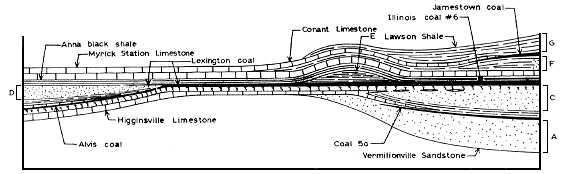
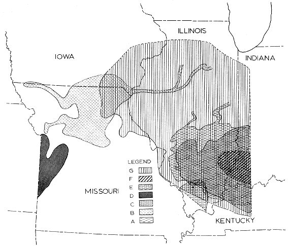
After the widespread deposition of black fissile shale (Anna) and marine limestone (Providence of western Kentucky, Brereton of Illinois, and Myrick Station of Missouri and Iowa), another small and local clastic wedge was introduced from the east in southern Indiana. The sediment of this wedge is mainly shale with some deltaic sand. Probably the greater part of this delta complex is east of the present Illinois Basin and has been destroyed. On this surface a commercial coal was deposited in parts of Indiana (locally coal VI) and western Kentucky (No. 12) and a thin noncommercial coal (Jamestown) in southern Illinois. This is capped in southern Illinois around the distal margin of the delta with another marine limestone, the Conant. Westward this limestone has been recognized in southern Iowa about 1 foot above the Myrick Station Limestone, but southward in Missouri this shale dies out and the Conant Limestone equivalent becomes only the upper bed of the Myrick Station. Figure 6 shows generalized outlines of the four clastic wedges thus far mentioned. Another wedge following the Conant Limestone separates the Brereton and Sparland cyclothems.
Figure 6--Geographic distribution of clastic wedges in Brereton cyclothem: (A) Vermilionville Sandstone (southern), (B) Vermilionville Sandstone (northern), (C) sandstone between coals 5a and 6, (D) Englevale Sandstone, (E) gray shale between No. 6 coal and Anna Shale, (F) shale and sandstone between Brereton Limestone and Jamestown coal, and (G) Lawson Shale.
Liverpool Cyclothem
The Liverpool cyclothem, in its typical area in western Illinois, includes, from the base up: (1) a sandstone, the Browning; (2) an underclay; (3) a coal, the Colchester (No. 2); (4) a gray shale, the Francis Creek, (5) a black fissile shale; (6) a massive limestone, equivalent to the Ardmore of Missouri; (7) a succession of four very thin marine limestones or ironstones (Oak Grove) separated by shales and in one instance locally siltstone or sandstone; and (8) an upper gray shale with ironstones. Because the lime-shale-sanironstone succession, the Oak Grove Member, appears to bear significantly on the complex regional problems of this interval, the units are separately listed here:
| Ironstone bed with fossil casts and molds (Crenipecten bed) | 0'2" |
| Gray shale with ironstones | 1'6" |
| Ferruginous fossiliferous limestone (Linoproductus bed) | 0'6" |
| Dark-gray flaky shale (Dunbarella shale) | 2'0" |
| Ferruginous limestone (Cardiomorpha bed) | 0'3" |
| Calcareous fossiliferous shale (Mesolobus bed) | 0'4" |
| Gray septarian limestone with cone-in-cone (Desmoinesia muricatina bed) | 1'0" |
| Unfossiliferous silty shale (Jake Creek Sandstone) | 1'0" |
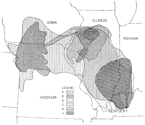
This sequence is unusual in the presence of the thick gray Francis Creek shale, which is a clastic wedge in the typical area, and in having such a complex sequence of limestones and shales as the Oak Grove Member in place of a single marine limestone to represent the transgression. Figure 7 is a very idealized cross section from northern Illinois southwestward and westward to Iowa, western Missouri and eastern Kansas. The clastic wedges involved in the Liverpool cyclothem are: (1) the Sebree-Palzo Sandstone of western Kentucky and southern Illinois (Potter, 1962, Pl. 1), a delta complex directed west and southwest in southern Indiana, western Kentucky and southeastern Illinois at the base of the Liverpool cyclothem; (2) a system of channels probably forming distributaries of a separate delta in northern Illinois, southeast Iowa and west-central Illinois (Browning), probably contemporary with (1); (3) the Francis Creek Shale, a prodelta shale extending southwestward from northern to west-central Illinois (this shale is sandy in its northeasternmost outcrops and in the same area contains the ironstone concretions rich in plant and animal fossils which have long been associated with Mazon Creek, Grundy County); (4) the Jake Creek "sandstone," a shale-sand complex from an easterly direction, on which the Lowell-Wheeler-Bevier coal swamp was supported, in part; (5) a clastic wedge which divides the Wheeler (lower) from the Bevier coal westward in Missouri, expanding from an inch or two of shale in eastern Missouri to 30 feet of shale near the Kansas line, illustrated in Figure 4 and described above (this wedge has a westerly source and the lower Wheeler coal locally has as a marine limestone caprock the Desmoinesia muricatina bed of western Illinois); and (6) a composite prodelta (Purington Shale) probably from the east or northeast, the uppermost portion of the Liverpool cyclothem. Figure 8 is a map showing approximate areas of the six clastic wedges mentioned.
Figure 7--Idealized cross section showing clastic wedges within the Liverpool cyclothem and its correlatives (not to scale): (A) Palzo Sandstone, southern Illinois Basin, (B) Browning Sandstone, northern Illinois (not shown), (C) Francis Creek Shale, (D) Jake Creek Sandstone and shale, (E) shale between Wheeler and Bevier coals, (F) Purington Shale (lower part of wedge; upper part is Pleasantview Sandstone, Summum cyclothem).
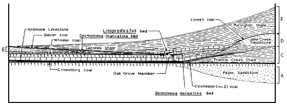
The ironstone, limestone, and shale units of the Oak Grove Member are believed to have the following significance in terms of clastic wedges:
Crenipecten ironstone bed (ironstone band in lower Lagonda Shale)
Gray Shale (lowermost part of Lagonda Shale)
Linoproductus limestone bed (cap of Bevier coal)
Dunbarella shale (roof shale of Bevier coal)
Cardiomorpha limestone (marine correlative of Bevier coal)
Mesolobus shale (calcareous marine shale above Wheeler coal)
Desmoinesia muricatina limestone bed (cap rock of Wheeler coal)
Jake Creek silty shale (clastic wedge below Wheeler coal)
As thus interpreted, the Oak Grove Member, only about 6 to 10 feet thick on the average, includes cap rocks of two coals (Bevier and Wheeler); two distal margins of clastic wedges; one marine roof shale; and the marine equivalent of one coal. Had the typical section of the Liverpool cyclothem been located elsewhere it might have been divided into a Bevier cycle, a Wheeler cycle, and a Croweburg cycle.
The Liverpool cyclothem has the following very widely extensive units of regional as opposed to local significance, listed in ascending order: (1) a basal sandstone (Sebree, Palzo, Browning); (2) a very widespread underclay; (3) the most extensive coal of the Pennsylvanian (No. 2 of Illinois, IIIa of Indiana, Schultztown of western Kentucky, Whitebreast of Iowa, Croweburg of the Midcontinent); (4) a widespread black fissile shale; (5) a cap limestone (Verdigris, Ardmore); (6) the Oak Grove marine zone; and (7) an upper shale (Purington, Lagonda). This suite of regionally extensive strata seem to compose a representative cyclothem. The other units of this complex succession are local and are present because of the influence of the clastic wedges which interrupt the regionally extensive Liverpool cyclothem.
Figure 9--Cross section showing merging of Houx Limestone, St. David cyclothem, and Higginsville Limestone, Brereton cyclothem in western Missouri.
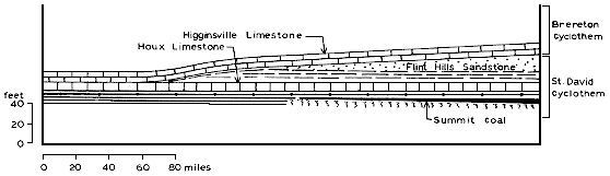
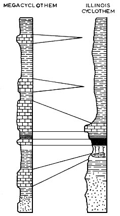
Figure 10--Generalized columns showing suggested relations between the megacyclothem of the northern Midcontinent and the cyclothem of Illinois.
The underclay limestone of Illinois is commonly a mass of nodules or a very unevenly bedded nodular limestone containing only algae of supposed fresh-water adaptation (Norman, 1959), but there are several instances of a marine limestone in the lower part of an Illinois cyclothem. The most widely distributed is the Bankston Fork Limestone (Universal of Indiana) which immediately overlies the basal Anvil Rock Sandstone of the Sparland cyclothem of southern Illinois, southwestern Indiana and parts of western Kentucky. This is equivalent to the Coal City or Upper Pawnee Limestone of Missouri and Iowa. There are several other examples of marine limestones in Illinois between the coal and the underlying sandstone, which will not be enumerated here.
There are other instances, notably: (1) the limestone below the Herrin (No. 6) coal, which is generally "fresh water" in Illinois, but is marine in the Midcontinent region (Higginsville Limestone or upper Fort Scott); and (2) the underclay limestone below the Summum (No. 4) coal of Illinois which is not known to carry a marine fauna in Illinois or eastern Missouri, but which becomes the marine Breezy Hill Limestone of western Missouri, Kansas, and northeastern Oklahoma. These observations suggest that, while underclay limestones in the Illinois basin commonly formed in fresh-water lakes or brackish lagoons, they were contemporary with transgressive marine limestones to the southwest.
If these suggestions are correct, the megacyclothem may be the Midcontinent equivalent of the Illinois basin cyclothem, rather than a combination of individual cyclothems as proposed by Weller (1958).
It is commonly thought that in most situations sediment supply has been adequate to maintain a profile of equilibrium, so that most sediment in transit would bypass the area, continuing on until a region of active downwarping is reached (Eaton, 1929; Twenhofel, 1950). Thus, a local thickening of a stratigraphic interval by 10 feet might be an indication of local downwarping in that amount. The Illinois Basin is divided into segments by the LaSalle Anticline, which is mainly a monocline with a steep west flank, and the Duquoin Anticline, similar to the LaSalle, but with a steep east flank. If thickening of stratigraphic intervals resulted simply from differential movement along these axes, most clastic intervals should be much thicker in the deeper Fairfield Basin between these folds than on the flanks. In the environmental mapping of middle Pennsylvanian strata recently completed (Wanless, Tubb, Gednetz, and Weiner, 1963, and later unpublished studies by C. Roseman, C. Manos, and D. Orlopp) there are numerous clastic wedges, generally delta and prodelta complexes, derived from a northeastern source. Most of these cross the LaSalle anticlinal belt nearly at right angles. Although hundreds of thicknesses have been plotted of the several clastic intervals, these have uniformly failed to show abrupt thickening on the downslope flank of the fold. From this it is deduced that this structure was inactive during the intervals mapped, having no topographic expression, and the sediment distribution was controlled by distance from the source area, paleoslope, climate, and the position of the strandline. The LaSalle Anticline was evidently tectonically active during parts of the early Pennsylvanian, where the clastic intervals have not yet been environmentally mapped. In such cases the shales and sandstones probably thicken abruptly on the down slope flank of the fold.
For the interpretation of geologic history local clastic wedges and associated strata afford excellent bases for determination of exact times and places of contemporary tectonism. Rough calculations involved in the volume of such a clastic wedge as the Francis Creek Shales, Liverpool cyclothem, would permit estimates as to magnitude of each separate uplift. Changes in paleoslope resulting from movements around the borders of a sedimentary basin may be determined from the directional trends of lenticular sandstones in successive cyclothems.
Another type of variation in number of cyclic sequences is found at a great distance from tectonically active areas where a series of marine limestones is no longer separated by shale or sandstone wedges, or in a deeper "starved" basin where shales replace most other sediment types.
It is proposed that the megacyclothem of the northern Midcontinent is the equivalent of the cyclothem of the Illinois Basin formed in regions nearer sources of marine transgression and farther from frequent sources of clastic sediment.
It is suggested that, although the clastic wedges may result from tectonism in distant highlands, their distribution is not influenced by differential downwarping of the sedimentary basin except where the axis of downwarping is coincident with the location of a thickened portion of the clastic wedge. Studies of thickness variation patterns of individual clastic wedges can therefore indicate times of local tectonism and of quiescence in the sedimentary basins.
It is hoped that this discussion may aid in the separation of local from regional elements in late Paleozoic cyclic successions and permit a sounder interpretive analysis of their depositional history than has been possible.
Cline, L. M., 1941, Traverse of Upper Desmoines and Lower Missouri Series from Jackson County, Missouri to Appanoose County, Iowa: Am. Assoc. Petroleum Geologists Bull., v. 25, p. 23-72.
Eaton, J. E., 1929, By-passing and discontinuous deposition of sedimentary materials: Am. Assoc. Petroleum Geologists Bull., v. 17, p. 713-761.
Hennen, R. V., and Reger, D. B., 1914, Logan and Mingo Counties: West Virginia Geol. Survey County Reports, 776 p.
Kellett, Betty, 1932, Geological cross section from western Missouri to western Kansas showing detailed correlation of Permian Big Blue and Pennsylvanian: Kansas Geol. Soc., cross section.
Kosanke, R. M., Simon, J. A., Wanless, H. R., and Willman, H. B., 1960, Classification of the Pennsylvanian strata of Illinois: Illinois Geol. Survey Rept. Inv. 214, 84 p.
Moore, R. C., 1931, Pennsylvanian cycles in the northern Midcontinent Region: Illinois Geol. Survey BuIl., 60, p. 247-258.
Moore, R. C., 1950, Late Paleozoic cyclic sedimentation in central United States: 18th Internat. Geol. Congress, London, Rept., pt. 4, p. 5-16.
Norman, E. K., 1959, Petrography of some Pennsylvanian underclay carbonate beds in Illinois: Unpub. master's thesis, Illinois Univ., 66 p.
Potter, P. E., 1962, Shape and distribution patterns of Pennsylvanian sand bodies in Illinois: Illinois Geol. Survey Circ. 339, 35 p.
Searight, W. V., 1959, Pennsylvanian (Desmoinesian) of Missouri: Missouri Geol. Survey Rept. Inv. 25, 46p.
Twenhofel, W. H., 1950, Principles of sedimentation, 2nd ed.: McGraw-Hill, New York, 673 p.
Wanless, H. R., 1931a, Pennsylvanian cycles in western Illinois: Illinois Geol Survey, Bull. 60, p. 179-193.
Wanless, H. R., 1931b, Pennsylvanian section in western Illinois: Geol Soc. America Bull., v. 42, p. 801-812.
Wanless, H. R., 1939, Pennsylvanian correlations in the Eastern Interior and Appalachian Coal Fields: Geol Soc. America Spec. Paper 17, 130 p.
Wanless, H. R., 1946, Pennsylvanian geology of a part of the Southern Appalachian Coal Field: Geol Soc. America Mem. 13, 162 p.
Wanless, H. R., 1947, Regional variations in Pennsylvanian lithology: Jour. Geology, v. 55, p. 237-253.
Wanless, H. R., 1962, Pennsylvanian rocks of Eastern Interior Basin, in Pennsylvanian System in the United States: Am. Assoc. Petroleum Geologists, Tulsa, p. 4-59.
Wanless, H. R., Tubb, J. B., Jr., Gednetz, D. E., and Weiner, J. L., 1963, Mapping sedimentary environments of Pennsylvanian cycles: Geol Soc. America Bull., v. 74, p. 437-486.
Wanless, H. R., and Weller, J. M., 1932, Correlation and extent of Pennsylvanian cyclothems: Geol Soc. America Bull., v. 43, p. 1003-1016.
Weller, J. M., 1930, Cyclical sedimentation of the Pennsylvanian Period and its significance: Jour. Geology, v. 38, p. 97-135.
Weller, J. M., 1931, The conception of cyclical sedimentation during the Pennsylvanian Period: Illinois Geol Survey Bull. 60, p. 163-177.
Weller, J. M., 1956, Argument for diastrophic control of Late Paleozoic cyclothems: Am. Assoc. Petroleum Geologists Bull., v. 40, p. 17-50.
Weller, J. M., 1958, Cyclothems and larger sedimentary cycles of the Pennsylvanian: Jour. Geology, v. 66, p. 195-207.
Willman, H. B., 1939, The Covel Conglomerate, a guide bed in the Pennsylvanian of northern Illinois: Illinois Acad. Sci. Trans., v. 32, p. 174-176.
Woerthen, A. H., 1870, Geology of Fulton County: Illinois Geol Survey, v. 4, p. 90-110.