
|
Original published in D.F. Merriam, ed., 1964, Symposium on cyclic sedimentation: Kansas Geological Survey, Bulletin 169, pp. 219-238 | |
1Columbia University and The American Museum of Natural History, New York, New York; 2Brown University, Providence, Rhode Island; 3Kansas Geological Survey, Lawrence, Kansas.
The Beattie Limestone of the northern Midcontinent region, including in ascending order the Cottonwood Limestone, FIorena Shale, and Morrill Limestone, has been the subject of a series of detailed field and laboratory investigations. This work has resulted in the identification, description, and interpretation of a variety of distinct facies. Preliminary results on the FIorena Shale were published by Imbrie (1955), and a detailed analysis of the Cottonwood Limestone was provided by Laporte (1962). In a previous paper the authors (1959) offered a tentative interpretation of the stratigraphy and paleoecology of the Beattie Limestone. Additional studies of the Morrill Limestone, as well as field experience in modern carbonate environments of the Florida Keys and the Bahamas, have confirmed many of our earlier ideas, and it seems appropriate now to summarize our views.
It is proper to acknowledge here the contributions made by several associates in this study. Louis S. Kornicker and Karl Turekian have worked with the senior author on the FIorena Shale. Raymond C. Moore assisted materially in solving certain stratigraphic problems in the field, and in discussion and correspondence gave freely of his extensive knowledge of Midcontinent stratigraphy and paleoecology. Russell T. Runnels has taken the responsibility of making and sharing in the interpretation of chemical analyses. Edward Jonas made x-ray analyses of several FIorena Shale samples. Robert W. Parkhurst helped accumulate, record, and interpret well-log data for the subsurface map. Published and unpublished maps and stratigraphic sections prepared by members of the staff of the State Geological Survey of Kansas provided the essential foundation on which our work was based. Studies by R. C. Moore, J. M. Jewett, H. G. O'Connor, K. L. Walters, and M. R. Mudge and E. L. Yochelson (1962) should be noted in particular. Unpublished studies by R. C. Taylor and D. L. Vosburg, prepared under the direction of Carl C. Branson, were invaluable in working out stratigraphic relations in Oklahoma. Maxim K. Elias not only gave needed assistance in locating critical exposures in Nebraska, but also, through his classic paper on "Big Blue" cyclothems (1937), provided much background and inspiration for the present study. Discussions with Norman D. Newell have been most helpful in clarifying our concepts of Permian paleoecology. Field assistance by Donald Hattin, Edward Purdy, and William Heaslip is gratefully acknowledged.
The Beattie Limestone constitutes a small portion of the Wolfcampian Stage in the northern Midcontinent region (Fig. 1). AIthough relatively thin (3-24 feet), the Beattie can be traced on the outcrop from Nemaha County, Nebraska, southward to Osage County, Oklahoma, and followed in the subsurface westward to the vicinity of the Colorado-Kansas line. It forms part of the well-known sequence of upper Paleozoic deposits in which marine beds (such as the Beattie) alternate with nonmarine beds (represented in the Beattie cyclothem by parts of the Eskridge Shale below and the Stearns Shale above).
Figure 1--Generalized stratigraphic section of Council Grove Group (Wolfcampian Stage) Lower Permian (adapted from Moore and others, 1951).
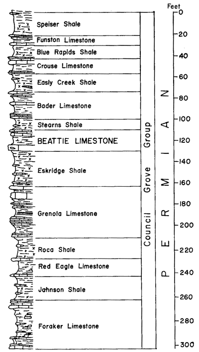
In general, strata in this part of the geologic column are laterally persistent and display a remarkable uniformity of thickness. Where thickness changes occur, they do so gradually and systematically. Subsurface studies show, for example, that the sequence from the base of the Crouse Limestone to the top of the Grenola Limestone is about 100 feet thick in northern Marshall County, Kansas, and that it thickens gradually to about 120 feet in southern Cowley County, Kansas. Westward from Marshall County the same sequence thins gradually to about 60 feet at the Colorado line. Although equally systematic, thickness variations of the Beattie Limestone (which falls within the sequence just named) are much more pronounced over the same region and exhibit an entirely different pattern. In northern Marshall County the Beattie is about 10 feet thick; in southern Chase County, about 25 feet; in southern Cowley County, 10 feet (Fig. 2). Westward from Marshall County the Beattie thins gradually to extinction near the Colorado-Kansas line. Within the Beattie, certain members display striking uniformity of thickness over considerable areas whereas others change rapidly within short distances. An outstanding example of uniformity is the Cottonwood Limestone, which on the outcrop over a distance of 150 miles from Nebraska to central Kansas maintains a thickness nowhere less than 5.5 nor more than 6.5 feet. The Florena varies from an inch or so in Osage County, Oklahoma where it is pinching out between two limestones, to an outcrop maximum of 15 feet in Chase County, Kansas.
Figure 2--A, Restored stratigraphic cross section showing facies distribution in Beattie Limestone along line of outcrop from Nemaha County, Nebraska, to Osage County, Oklahoma. Datum is top of Florena Shale. Facies boundaries determined from data obtained in foot-by-foot sampling at each of 24 measured sections. For description of facies, see text. For location of sections, see Figure 3 (from Imbrie, Laporte, and Merriam, 1959). B, Restored section of Cottonwood Limestone showing areal distribution of facies. Datum is top of Cottonwood Limestone (Laporte, 1962). A larger version of this figure is available.
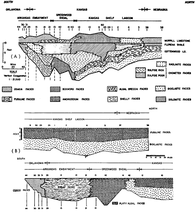
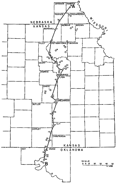
Figure 3--Beattie Limestone sampling localities. Line of section in Figure 2.
Our approach to facies definition has been to examine and evaluate a large number of lithic and paleontologic parameters. Observations made in the field, including stratigraphic relationships, were supplemented with laboratory studies employing petrographic, mineralogic, chemical, and paleontological techniques. Rock attributes that confer distinctive field characteristics are important aids to the determination of stratigraphic relationships, but exclusive reliance on such attributes gives a biased and sometimes misleading basis for genetic interpretation.
Ten distinct facies may be recognized in the Beattie Limestone. Some of these (e. g. the fusuline facies) consist of a single lithologic type. Others comprise two or more lithologies found in close geographic and stratigraphic association. The following brief descriptions indicate only the most diagnostic lithic and faunal characteristics.
(1) Osagia facies. Beds classed as Osagia facies contain a significant proportion of grains coated by the algal-foraminiferal consortium Osagia. Three varieties of Osagia facies can be recognized. Type a (osagite) is a dense, pure limestone containing conspicuous subspherical or bean-shaped Osagia-coated grains typically making up 40 percent of the rock and 80 percent of the biota. Type b is a silty limestone containing 5 to 10 percent quartz silt and fewer Osagia than Type a. Molluscs, echinoderms, and the alga Epimastopora are the most abundant associated fossils in both Type a and Type b. Type c (Osagia marl) is an argillaceous limestone containing Osagia as the dominant fossil (80 percent of the biota) and 10 to 15 percent clay. Fusulines, echinoids, and the brachiopod Composita are the most abundant associated fossils.
(2) Shelly facies. This facies is characterized by an unusually diverse and well-preserved fauna occurring in thin (1- to 6-inch) layers of calcareous shale and limestone. The facies averages 60 percent CaCO3, and 75 percent of the rock is composed of clay and carbonate grains smaller than 1/8 mm. Brachiopods and molluscs commonly dominate the fauna, although some beds contain abundant ammodiscid and hyperamminid foraminifera. Many larger fossils are found unbroken and articulated. The following fossils, although rare, have been found only in this facies: intact ophiuroids, intact crinoids, bellerophontid gastropods, the snail Omphalotrochus, and cephalopods. Subcylindrical casts of burrows, some but not all of which are due to the activity of burrowing clams and arthropods, are abundant.
(3) Platy algal facies. Rocks of this facies are pure limestones (greater than 90 percent CaCO3) containing the platy alga Anchicodium as the dominant organism. Osagia, the brachiopod Crurithyris, and bryozoans are the most common associated organisms. About 70 percent of the rock is made up of grains smaller than 1/8 mm. Weathered platy algal limestones have a distinctive crinkled aspect in outcrop.
(4) Fusuline facies. Rocks of this facies are limestones (90 percent CaCO3) containing nodular chert and abundant fusulines, mostly Schwagerina. Fusulines make up about 25 percent of the rock and 50 percent of the biota. Osagia, the most abundant associated organism, makes up 10 to 15 percent of the rock and 25 percent of the biota. Other skeletal material is finely broken. About 50 percent of the rock is made of grains smaller than 1/8 mm.
(5) Bioclastic facies. Rocks of this facies are limestones (90 percent CaCO3) containing nodular chert and an assemblage of finely broken fossils dominated by Osagia. This fossil makes up about 20 percent of the rock and 50 percent of the biota. Here, the alga occurs as broken and isolated fragments as well as grain-coatings (cf. Osagia facies). Bryozoans and echinoderms are the most common associated organisms. About 60 percent of the rock is made of grains smaller than 1/8 mm.
(6) Kaolinite facies. Rocks of this facies are calcareous shales (including thin interbedded limestones) in which kaolinite forms a significant proportion of the clay minerals. Although many beds are stained a faint red from traces of contained hematite, the fauna is definitely marine. Two fossils are found exclusively in this facies: small, high-spired, subulitid snails and pentagonal crinoid columnals. The fauna as a whole is sparse, specialized, and difficult to detect in the field.
(7) Chonetid facies. Rocks of this facies include calcareous shales and argillaceous limestones containing a fauna dominated by brachiopods, bryozoans, crinoids, and echinoids. The brachiopod Neochonetes is especially characteristic. In contrast to the shelly facies, this fauna is less diverse, contains fewer molluscs, and lacks burrow casts. Two varieties of this facies can be distinguished. Type a is relatively rich in pyrite and clay (25 to 50 percent); Type b is relatively poor in pyrite, fossils, and clay (15-30 percent) and relatively rich in strontium.
(8) Dolomitic shale facies. Rocks of this facies contain 20 to 70 percent dolomite, which occurs as microscopic rhombs in a matrix of clay and calcite grains. Although calcareous fossils are rare, orbiculoid brachiopods, fish remains, and conodonts are present. In the field this facies can be recognized by its distinctive blocky weathering. The original dark-gray color of rocks of this facies and the chonetid facies is commonly bleached on outcrop to a buff or pale yellow.
(9) Algal-biscuit facies. Rocks of this facies are dense, pure limestones containing concentrically laminated, biscuit-shaped algal colonies an inch or more in diameter. Carbonate intraclasts are common.
(10) Boxwork facies. Rocks of this facies can be classified into many distinctive subfacies. These include (1) dolomitic limestone and dolomite which weathers into a "boxwork" of intersecting dolomitic plates, (2) unfossiliferous limestone with pink or reddish-brown chert, (3) dove-colored lime mudstones with small vertical burrows, and (4) laminated dolomitic limestone with mudcracks, some of which are reworked and occur as intraclasts.
Boundaries between facies in the two Beattie limestone members were originally drawn by inspection of field data alone. Although laboratory data obtained subsequently provided additional and useful information, it did not necessitate significant alteration of these boundaries. In the case of the Florena Shale, however, field inspection was supplemented by statistical procedures employing a high-speed digital computer and taking into account general tendencies in a large number of lithologic and paleontologic attributes determined in the laboratory. These statistical techniques, similar to those used by Imbrie and Purdy (1962) and Purdy (1963) to classify modern Bahamian sediments, served to evaluate differences detected in the field and laboratory by ordinary procedures. This evaluation enabled us to distinguish the shelly from the chonetid facies of the FIorena at locality 14, for example, where field criteria for the separation are not convincing alone.
Although valid inferences can be drawn from an inspection of lithic and paleontologic characteristics alone, many uncertainties inevitably remain in the paleoecologic interpretation of Paleozoic rocks. Important additional clues can be obtained upon consideration of the geographic relationships of contemporaneous facies. As will be demonstrated below, the geographic pattern of facies distribution depicted in Figure 2 contributes materially to an understanding of conditions of deposition during Beattie time.
The validity of these interpretations naturally depends on the accuracy of the correlations. Recognizing this, we have exerted every effort to determine chronologic relationships correctly. Detailed field examination reveals the presence of distinctive marker beds. Although none of these key beds can be traced the full length of the Beattie outcrop, sets of marker strata with overlapping geographic ranges provide a secure stratigraphic framework. Among these may be mentioned: (1) the fusulinid and bioclastic beds of the Cottonwood from locality 12 and north; (2) a 3- to 6-inch fusuline bed at the top of the Cottonwood from locality 40 to locality 35; (3) sulfide chonetid facies of the lower FIorena from locality 3 southward to locality 13 (excepting locality 50); (4) the dolomitic shale bed of the upper FIorena from locality 1 southward to locality 40; (5) the kaolinite- and subulitid-bearing beds of the FIorena from locality 15 south to locality 44; (6) "boxwork" and associated cherty beds of the Morrill from locality 2 south to locality 12; (7) the algal-biscuit beds of the Morrill from locality 42 northward to locality 12 where they interfinger with the "boxwork" zones of the Morrill; and (8) the Morrill Limestone from locality 13 south to locality 44 has a persistent microstratigraphy which includes distinctive, dense osagite limestone with large vertical burrow molds formed by clams Aviculopinna and Allorisma. Small-scale intertonguing of adjacent facies, moreover, supports the correlations made from the key beds alone. For example, platy algal beds just a few inches thick are found within the Cottonwood for several tens of miles north of locality 40 where the fully developed platy algal facies first appears. Finally, Beattie Limestone strata can be distinguished from the Stearns Shale above and the underlying Eskridge Shale by its markedly greater carbonate content. Similarly, Florena strata are more argillaceous than those of the other two Beattie members.
Figure 4 is an isopach map of the Florena Shale contoured on a 4-foot interval; west of the line of Cottonwood outcrop it is based on several thousand electric logs, laterologs, and radioactivity logs from wells scattered widely over the state (for documentation of control points, see Merriam, 1963, p. 99). Surprisingly, regional variations in thickness are shown not only to be systematic but also to coincide with several known structural features such as the Nemaha Anticline, Sedgwick Basin, and Salina Basin. This coincidence of known structural features with Florena isopachous patterns suggests that the narrow zone of thin FIorena observed on the outcrop (localities 13 to 41) and in the subsurface in northern Cowley County and southern Greenwood County may reflect differential subsidence.
Figure 4--Isopachous map of Florena Shale based on 50 surface sections along line of Cottonwood outcrop and about 2,500 electric logs of wells scattered over state west of outcrop (outcrop of Cottonwood Limestone from Moore and Landes, 1937). A larger version of this figure is available.
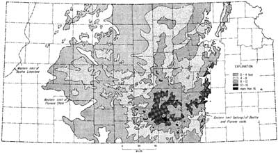
Figure 5 represents an interpretation of northern Midcontinent geography at the time of deposition of the Beattie Limestone. During this time Kansas was occupied by an elongate seaway or strait extending southeast from northeastern Wyoming to Arkansas and northeastern Oklahoma. The seaway, here called the Kansas Strait, separated the low-lying continent to the north from tectonically active lands to the south and west, occupying portions of Utah, Colorado, Arizona, New Mexico, southern Oklahoma, and Texas. Waters of the Kansas Strait probably communicated with the open ocean principally to the southeast by way of an arm of the sea, here called the Arkansas Embayment. A second access to open oceanic waters may have been present from western Oklahoma through the Texas Panhandle.
Figure 5--Geography inferred for Beattie Limestone sea. Based in part on data provided by Paleotectonic Map Unit of United States Geological Survey and in part on independent surface and subsurface studies by the authors.
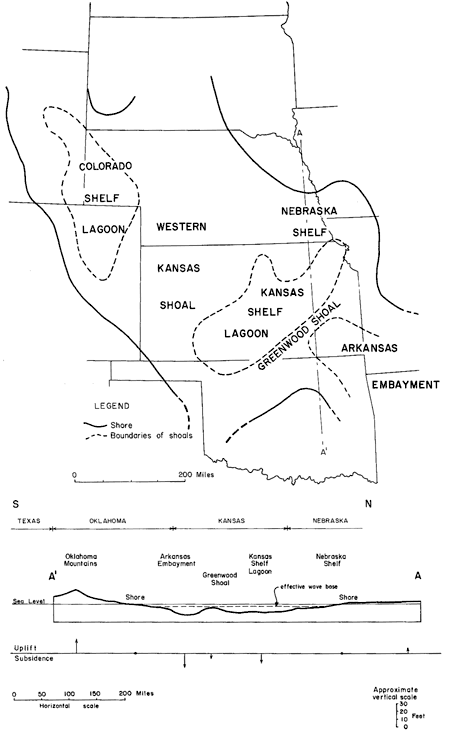
Isopach and facies data for the Beattie strongly suggest that the Strait was subdivided by a shoal area (here called the Greenwood Shoal) extending southwest-northeast across southeastern Kansas through Greenwood County. This shoal area apparently impeded exchange of water in the Kansas Shelf Lagoon with the oceanic reservoir that lay to the southeast and southwest. Directly south of the Beattie sea were tectonically active highlands of central Oklahoma, which at times were sources of terrigenous detritus.
Nearshore facies--Examination of lateral facies changes in the three members of the Beattie Limestone near their present northern and southern outcrop limits is tantamount to studying nearshore-offshore facies sequences along the borders of the Kansas Strait. Five out of six of these sequences reveal a distinct and rapid facies change near shore; only the northern Cottonwood facies remain unchanged over the present outcrop area as the Nebraska shoreline is approached. In four of the five sequences exhibiting lateral change, the Osagia facies lies nearest the shoreline. This relationship, together with intrinsic attributes of the Osagia facies, indicates that the facies reflects a shallow, turbulent, nearshore environment in which the accumulation of terrigenous detritus is relatively small. Modern oncolites, judged to be related to Osagia, form in waters just below mean low tide to depths of about one fathom in the Bahamas. The southern, nearshore facies of the FIorena (kaolinite facies) is interpreted as a shallow, oxidized, turbulent environment to which terrigenous detritus was supplied rapidly from the Oklahoma highlands.
The Greenwood Shoal--Several independent lines of evidence indicate that during the deposition of the Beattie Limestone an elongate shoal separated two distinct facies provinces in the Kansas Strait. As indicated in Figure 5, this shoal probably extended northeast-southwest across the Strait from shore to shore. Besides the isopachous data cited above, evidence for this shoal is enumerated below.
Zone of facies change: Along the same area of outcrop marked by thin Florena, all three members of the Beattie Limestone undergo significant facies changes. Abrupt facies changes in such an offshore position strongly suggests primary topographic control within the depositional basin.
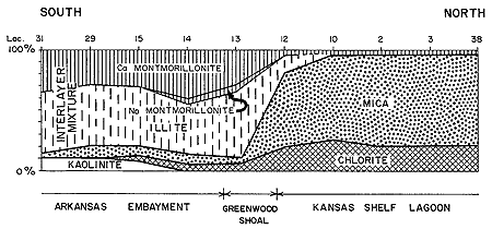
Lithologic evidence: Supporting evidence for the Greenwood Shoal comes from a study of intrinsic rock characteristics in each of the three Beattie members. Algal biscuits and intraclasts in the Morrill clearly indicate turbulent, shallow conditions of the sort found today in water a few feet deep or on supratidal carbonate mudflats in the Bahamas and Florida. Evidence from the Florena is shown in Figure 6. North of the postulated shoal, clay minerals in the Florena are dominantly mica and chlorite; south of it they are chiefly an illite-montmorillonite mixture. Two source areas are thus indicated, one north and one south of the Strait, a shoal separating the sea into two basins. The quantity of clay in various parts of the Florena independently suggests that clay originating in lands bordering the Strait tended to by-pass the shoal and concentrate in the flanking topographic lows. Platy algal facies such as those in the Cottonwood have been interpreted as shoal deposits by various authors (see Laporte, 1962, for review of the evidence).
Figure 6--Percentage composition of Florena clay at selected localities along outcrop. Data for each locality based on two or three samples taken to represent each facies present. Vertical changes in clay mineral composition at individual localities have not been observed. X-ray analyses by Edward Jonas.
Faunal provinces: The postulated Greenwood Shoal coincides with an important faunal boundary. Fossils in the shelly facies south of the shoal are more diverse than the relatively specialized fauna of the northern province. The molluscs, especially, are as a group much more varied and abundant in the southern province. Particularly noteworthy is the distribution of bellerophontid gastropods, cephalopods, and the gastropod Omphalotrochus. These fossils--whose distribution in the Beattie is restricted to the shelly facies south of the shoal--are known from many localities in Texas, New Mexico, Arizona, and California. Seemingly, they inhabited waters freely circulating with the open ocean. The abrupt termination of this fauna at the postulated topographic axis suggests an ecologically unfavorable environment to the north which prevented the establishment of these open ocean organisms in that area.
Facies of the Kansas Shelf Lagoon--Five Beattie facies are situated between the Greenwood Shoal and the nearshore Osagia facies of the Nebraska Shelf: fusuline facies, bioclastic facies, chonetid facies, dolomitic shale facies, and boxwork facies (Fig. 7, 8). Together they constitute a facies province reflecting conditions peculiar to the shallow waters of the Kansas Shelf Lagoon, where the Greenwood Shoal prevented free interchange with waters of the Arkansas Embayment. Although there may have been exchange between the Kansas Shelf Lagoon with waters lying to the northwest and east, these water masses were equally distant and isolated from the open oceans and hence could not support a typical diverse, normal marine biota.
Figure 7A--Upper part of Beattie Limestone at locality 35. Bed of Morrill Limestone is 8 inches thick and riddled with vertical burrow molds of clams. Florena Shale is 3 inches thick, and occupies re-entrant immediately below Morrill. Hammer handle rests on uppermost bed of Cottonwood Limestone.
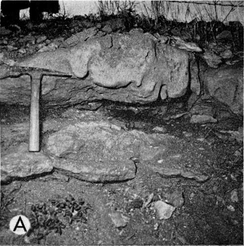
Figure 7B, Beattie Limestone at locality 31. FIorena Shale is 8 inches thick and is exposed immediately behind hammer. Morrill Limestone above is osagite with conspicuous vertical burrow molds of clams. Cottonwood Limestone here is interbedded calcareous shale and thin, rubbly limestone beds.
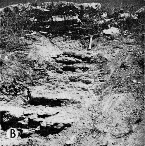
Figure 7C, Beattie Limestone at locality 29. Florena Shale, 2.5 feet thick. Cottonwood-Florena contact is at shoulder height of investigator. Morrill Limestone, badly weathered at this spot, has characteristic aspect of southern Morrill, a few feet away (osagite with vertical clam borings). Cottonwood (shelly facies) is exposed from Florena down to Eskridge Shale, which occurs in small trench dug at investigator's feet.
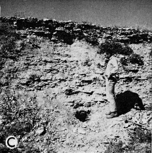
Figure 7D, Cottonwood Limestone at locality 46 near locality 42. (New exposure reveals entire Florena to be 8 feet thick, and although trench samples have not been studied, sparse fauna from upper part suggest that some dolomitic beds are present.) Characteristic crinkly surface of platy alga facies of Cottonwood is shown. Note irregular thickness.
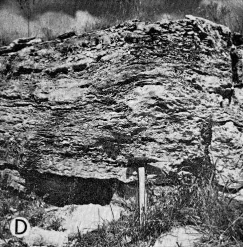
Figure 7E, Beattie Limestone, locality 10. Florena Shale (11.5 feet thick) is exposed above conspicuous bench of Cottonwood Limestone. Morrill Limestone is at top of cut. This exposure is typical field expression of Beattie between Greenwood Shoal and Kansas-Nebraska line.
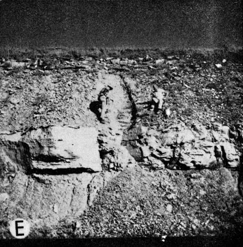
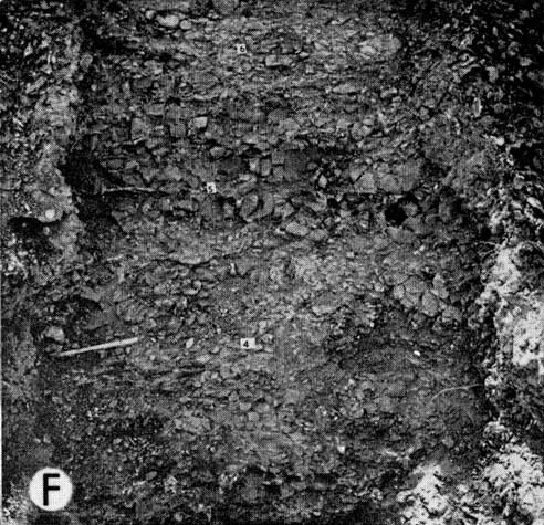
Figure 7F, Cottonwood Limestone at locality 22 (see locality map, Figure 3). Typical appearance of Cottonwood Limestone north of Greenwood Shoal. Upper part of unit is fusuline facies; lower part, bioclastic facies. Chert nodules are characteristic.
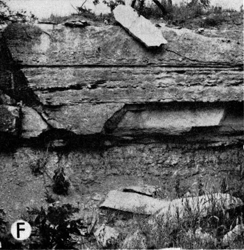
Figure 8A, Beattie Limestone at locality 3. Florena Shale is 2.75 feet thick, exposed behind pick. Note thin argillaceous limestone bed in Florena. Cottonwood Limestone is identical to that exposed elsewhere in northern facies province.
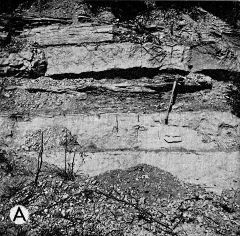
Figure 8B, Part of Beattie Limestone at locality 38. Florena Shale, 1.5 feet thick, lies between the horizons numbered 23 and 25 on the photograph. It is composed of alternating beds of argillaceous limestone and calcareous shale. Osagia nodules are common throughout Florena at this locality. Cottonwood Limestone below has typical characteristics of unit where exposed elsewhere in northern facies province including abundant Schwagerina.
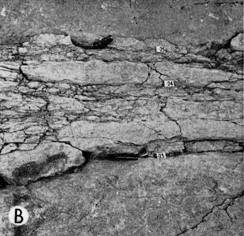
Figure 8C, Cottonwood-Eskridge contact at locality 15. Hammer head is on lowermost bed of argillaceous limestone in Cottonwood. Above this horizon Cottonwood is shelly facies, and is richly fossiliferous. Eskridge below is shale.
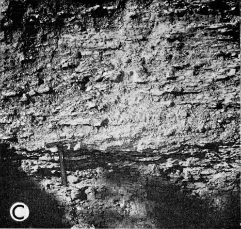
Figure 8D, Close-up of lower Florena at locality 3. Note fossils and stratification of typical chonetid facies of Florena.
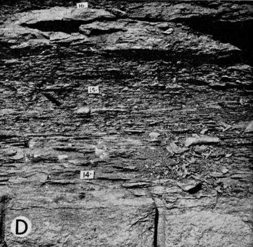
Figure 8E, Close-up of Florena Shale at locality 14, showing burrow casts in place in richly fossiliferous calcareous shale. Number card in picture is about 1 square inch.
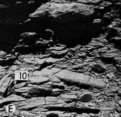
Figure 8F, Close-up of Florena Shale at locality 1. Numbered cards are one foot apart and show distance in feet above Cottonwood. Note blocky weathering, characteristic of dolomitic facies of Florena.
The abundance of algae, the finely comminuted texture of most of the contained skeletal material, and the presence of crossbedding in the bioclastic and fusuline facies indicate that these facies were deposited in shallow water. Their impoverished fauna is interpreted as the effect of some ecologic factor or set of factors associated with restricted water circulation.
The chonetid shale reflects somewhat deeper, quieter conditions accompanied by a sharply increased rate of supply of clay derived mostly from the low-lying continent to the north. Judging from the diversity of the Neochonetes fauna, ecologic conditions were more nearly normal than those prevailing during Cottonwood deposition but still abnormal compared with those of the Arkansas Embayment. Late Florena time saw the development of markedly stronger salinities and the penecontemporaneous formation of dolomite. Generally shallowing conditions during Morrill time produced a nearly isolated shoal lagoon in which small topographic features resulted in rapid lateral variations in sediment type. Presence of thinly laminated unfossiliferous dolomites and dolomitic limestones with mudcracks at several localities near or on the Greenwood Shoal indicate local supratidal mudflats; similar deposits are forming today inches above the mean high tide level in the Florida Keys and along coastal areas of western Andros Island (Shinn and Ginsburg, 1964).
Facies of the Arkansas Embayment--Three superposed facies (shelly facies, chonetid facies, and fusuline facies) situated between the nearshore Osagia and kaolinite facies to the south and the Greenwood Shoal to the north are interpreted as reflecting conditions in a distinct portion of the Kansas Strait termed the Arkansas Embayment. In general, waters of the embayment were quieter, somewhat deeper, and exhibited more nearly normal ecologic conditions than those of the lagoon to the north. In both basins, however, late Beattie deposition was accompanied by a progressive increase in salinity. In the southern province, the vertical facies sequence is shelly facies-chonetid facies-fusuline facies; in the north, it is chonetid facies-dolomitic shale facies-boxwork facies.
The environment of the shelly facies is interpreted as that of normal salinity and quieter and deeper water below the zone of maximum turbulence. Here, terrigenous muds by-passing shallower water to the south, came to rest. Deposition of Morrill fusuline-bearing limestone represents a shallower, clay-free condition and increased restriction. The location of these fusuline beds in a narrow belt flanked by osagite, together with the abundance of Osagia associated with the fusulines, indicates that the fusulines preferred depths and conditions just marginal to those of Osagia, and were shoal-water dwellers. Therefore, a far offshore position (for Morrill fusulines, at least) is not warranted.
(1) Studies of lateral facies changes within the Beattie Limestone contribute significantly to an understanding of their genesis.
(2) A simple transgression-regression hypothesis is not adequate to explain facies pat. terns observed within the Beattie, a point further elaborated by Laporte and Imbrie in this volume.
(3) In explaining the Beattie facies, consideration must be given to other factors, mainly hydrographic, including water turbulence, water circulation, and rate of terrigenous influx.
(4) Many Beattie facies clearly originated at or very near to mean sea level. The mudcracked, intraclastic dolomitic beds of the Morrill are thought to have formed just above mean high tide; the Osagia beds in depths of a fathom or less; and the fusuline and bioclastic facies in waters slightly deeper than the Osagia facies.
Elias, M. K., 1937, Depth of deposition of the Big Blue Series (late Paleozoic) sediments in Kansas: Geol. Soc. America Bull., v. 38, p. 403-432.
Ginsburg, R. N., 1956, Environmental relationships of grain size and constituent particles in some south Florida carbonate sediments: Am. Assoc. Petroleum Geologists Bull., v. 40, p. 2384-2427.
Imbrie, John, 1955, Quantitative lithofacies and biofacies of Florena Shale (Permian) of Kansas: Am. Assoc. Petroleum Geologists Bull., v. 39, p. 649-670.
Imbrie, John, and Purdy, E. G., 1962, Classification of modern Bahamian carbonate sediments, in Classification of carbonate rocks, a symposium: Am. Assoc. Petroleum Geologists Mem. 1, p. 253-272.
Imbrie, John, Laporte, L. F., and Merriam, D. F., 1959, Beattie Limestone facies and their bearing on cyclical sedimentation theory: Kansas Geol. Soc. 24th Field Conf. Guidebook, p. 69-78.
Laporte, L. F., 1962, Paleoecology of the Cottonwood Limestone (Permian), northern Mid-Continent: Geol. Soc. America Bull., v. 73, p. 521-544.
Lloyd, R. M., 1964, Variations in the oxygen and carbon isotope ratios of Florida Bay mollusks and their environmental significance: Jour. Geology, v. 72, p. 84-111.
Merriam, D. F., 1963, The geologic history of Kansas: Kansas Geol. Survey Bull. 162, p. 1-317.
Moore, R. C., and Landes, K. K., 1937, Geologic map of Kansas; Kansas Geol. Survey, map.
Moore, R. C., and others, 1951, The Kansas rock column: Kansas Geol. Survey Bull. 89, p. 1-132. [available online]
Mudge, M. R., and Yochelson, E. L., 1962, Stratigraphy and paleontology of the uppermost Pennsylvanian and lowermost Permian rocks in Kansas: U. S. Geol. Survey Prof. Paper 323, p. 1-213.
Purdy, E. G., 1963, Recent calcium carbonate facies of the Great Bahama Bank, 1 petrography and reaction groups: Jour. Geology, v. 71, p. 334-355; 2 sedimentary facies: Jour. Geology, v. 71, p. 472-497.
Shinn, Eugene, and Ginsburg, R. N., 1964, Formation of Recent dolomite in Florida and the Bahamas (abs.): Am. Assoc. Petroleum Geologists Bull., v. 45, p. 547.
Not available at this time.