
|
Original published in D.F. Merriam, ed., 1964, Symposium on cyclic sedimentation: Kansas Geological Survey, Bulletin 169, pp. 171-181 | |
University of Notre Dame, Notre Dame, Indiana
Detailed studies have been made in portions of western Montana of rocks on either side of the Devonian-Mississippian boundary. The sequence consists of Jefferson-Three Forks Formations (Upper Devonian), Sappington Formation (Devonian-Mississippian), and Lodgepole Limestone, Madison Group (Lower Mississippian). This gives a succession which extends from the transgressive marine carbonates of the Jefferson Formation through the regressive fine clastics of the Sappington Formation to the transgressive Lodgepole Limestone. It is this intersystemic cycle, and in particular the detailed physical and biological characteristics of the Sappington units, that is the basis of this paper. Some indication of cyclical nature of the microfaunas in the Lodgepole Limestone is also given.
The area under consideration involves the Cordilleran geosynclinal shelf. Relative oscillation of sea level in the geosyncline, possibly related to the Acadian Disturbance, may have controlled the vertical change in sedimentary facies. There is a remarkable similarity of this sequence with the Ohio Shale-Bedford Shale-Berea Sandstone-Sunbury Shale of the Appalachian Basin (Pepper, DeWitt, and Demarest, 1954), which is based on tectonic framework, individual lithologies, and succession of lithologies and environments, ages of units, and sedimentary features.
Acknowledgments--lndiana University Geological Field Station served as a base of operations for the field studies, and help from members of its staff is gratefully appreciated. The study has been supported in part by the National Science Foundation Undergraduate Research Participation grant G 16222 and will continue under Grant GP-1197. Lee J. Suttner aided in the field work and made laboratory analysis of the Lodgepole residue study. William J. McMannis, Montana State College, and Charles Sandberg and Melville R. Mudge, U. S. Geological Survey, were helpful in discussing the problem and locating several key sections. Donald F. Toomey, formerly of Shell Oil Company, furnished photographs of the algal nodule.
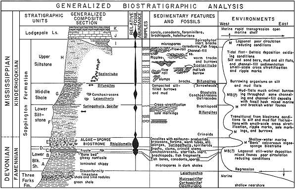
Summary of the generalized biostratigraphy for the Devonian-Mississippian succession is given in Figure 1. Eight informal stratigraphic units have been recognized for the Sappington Formation and three units are shown for the lowermost Lodgepole Limestone. No attempt has been made to assign letters to the units in the Three Forks Formation (Three Forks Shale of some authors). Some idea of the regional distribution can be realized from the selected list of localities given. Details of the sequence, starting from the uppermost Three Forks Formation and proceeding upwards in the section, are as follows.
Figure 1--Generalized geologic summary of biostratigraphic analysis of Sappington Formation of western Montana and its relationship to underlying Three Forks Formation and overlying Lodgepole Limestone (Gutschick, Suttner, and Switek, 1962). A larger version of this figure is available.
Three stratigraphic units are recognized in the upper green shale member of the Three Forks Formation. They are a greenish-gray, fossiliferous shale, which makes up the bulk of the member; a thin, 2 or 3 feet, shale containing many irregularly rounded limestone nodules; and an upper gray, fine-grained, fossiliferous limestone. The lime nodules seem very persistent in their position beneath the upper limestone, and they have wide geographic distribution. They are interpreted to represent shallow water break-up of thin limestone beds within shales to produce a zone of water eroded nodules. The upper Three Forks unit, as part of the Cyrtospirifer zone, contains numerous fossils firmly establishing a Late Devonian age.
There is a sharp lithologic division between the Three Forks and Sappington Formations which represents an erosional unconformity (McMannis, 1962). The lower black shale of the Sappington Formation rests upon a surface of erosion which apparently has very low relief. In widely separated places such as Antelope Valley, Logan, and North Sawtooth Mountain, the black shale rests upon the upper limestone. It is on the shale containing thin limestone layers at Nixon Gulch and shows 6 inches to 1 foot of relief in 10 to 15 feet laterally; whereas at Beaver Creek it rests upon the green shale. A weathered clay, 1 or 2 inches thick and interpreted as a soil zone, is present in several places, e.g., Logan and North Sawtooth Mountain. This contact is usually concealed and requires lateral trenching to appreciate its significance in a single section.
Lower Black Shale (A), (B), and (C)--At least three distinct characteristics have been recognized in the lower dark shale, and these have been used to differentiate units (A, B, and C). Shale of lower unit A is well laminated but not fissile. It has a dull luster and weathers into slopes of chippy residual debris. This shale subunit is believed to represent depression fills on the erosional surface. Fossils are scarce except for plant spores and very few conodonts. More than 7 feet of this shale has been observed in the Bridger Mountains and Beaver Creek sections.
Unit B consists of dark-gray, bright, glossy, contorted, carbonaceous shale which crumbles and breaks with subconchoidal fracture. The shale lacks the flat lamination of subunits A and C. Fossils are absent except for plant spores. Freshly exposed shale appears to be slickensided suggesting structural deformational slippage along this zone; however, it occurs in many widely separated localities so as to make coincidence unlikely. Six feet of this shale has been measured in the Antelope Valley section.
Unit C is a remarkably persistent bed of dark brownish-gray to brownish-black, thin (less than 1 foot), compact, fissile shale. It has wide distribution and uniformity of lithology and fossils. This unit forms the top bed in the lower dark-shale sequence and often forms a minor resistant ledge because of its compactness. The shale has a dull, satiny luster compared to the bright glossy appearance of unit B. This is the most fossiliferous bed in the black-shale sequence and contains an unusual assemblage (Fig. 2). Conchostracans are present wherever the shale occurs. They are so abundant on certain bedding laminations as to cover the surface. Several localities have small starfish associated with the bivalved arthropods, e. g., Nixon Gulch and Logan. The starfish and estherians are whole and well preserved suggesting extremely quiet-water deposition. Diagenetic environmental pH changes have caused leaching of the calcareous skeletons of the starfish so that they are preserved as external molds in the shale. The conchostracans have well preserved casts and impressions of both valves intact but completely open. The fauna of unit C includes inarticulate brachiopods, starfish, conchostracans, conodonts, fish fragments, and plant spores.
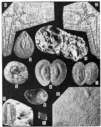
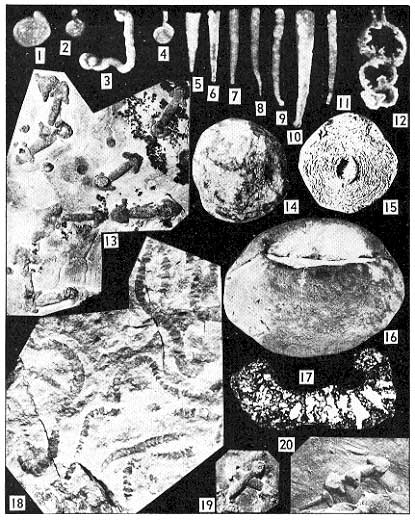
Figure 2--Sappington fauna. Illustrations 1-7, 11 are from the lower black shale unit C, Nixon Gulch locality no. 8; illustrations 8-10 are from a channel-fill in the middle shale Unit G, Antelope Valley Locality no. 7. 1 and 2, Counterparts of a single individual starfish from along bedding in fissile shale. 3, Lingula sp. 4 and 5, Orbiculoidea sp. 6 and 7, Leioestheria. sp. internal and external molds showing compaction. 8, Leioestheria sp. single uncompressed valve. 9, Forked radial and basal plates of a blastoid. 10, Worm (?) fossil concentration. 11, Paleoniscoid fish scale. Scale approximately X 4 except figure 10, X 2/3. A larger version of this figure is available.
Withdrawal of Three Forks seas for a short time allowed subaerial erosion to develop an area of low relief and a thin soil. Shallow lagoons of restricted water circulation formed in low areas; dark muds accumulated under the reducing conditions of this environment. As the level of the shallow, poorly circulated waters rose and the lagoons were expanded, muds of unit A continued to fill the depressions and turgid muddy waters spilled over into other areas to deposit the shales of unit B. Eventually a broad shallow lagoonal area of exceedingly quiet waters laid down the dark muds which became the fissile shales of unit C. It is not clear how the marine starfish and brackish or fresh (?) water conchostracans became associated together in such an excellent state of preservation. The starfish are whole and give no indication of thrashing about and the bivalved arthropods have the delicate connections between valves intact.
Green-Gray Shale Unit (D)--Several inches of light olive-gray, fossiliferous shale occurs between the lower dark shales and the overlying algae-sponge biostrome. The contact at the base with the dark shales is fairly sharp; whereas the upper contact is gradational with the overlying beds. The shale is granular and noncalcareous except for white, limey shell material. The lime content increases upwards with the increase of fossil shells. The fauna consists of brachiopods, clams, snails, and crinoid stems. Compaction has deformed the shells and the lime has been leached so that the fossils are preserved as internal and external molds that exhibit fine details.
Environmental conditions changed abruptly from the restricted circulation of the lower black shales to this unit. This is reflected by change in color of the sediments and by fauna content.
Algae-Sponge Biostromal Unit (E)--Perhaps the most remarkable stratigraphic unit in the Sappington sequence is the persistent widespread biostrome characterized by calcareous algal nodules (oncolites) and sponges. Lithologically the unit is a mixture of lime, silt, and clay which makes it difficult to name. The presence of the fossils suggests that it is a silty, argillaceous limestone with tendency to be shaly. It is consistently close to 5 feet in thickness and has sheetlike distribution. It has been recognized in a north-south direction from Beaver Creek northeast of Helena to Leatham Hollow near Logan, Utah; and eastwest from the Bridger Mountains to the Red Hill section west of Three Forks, Montana. The lower boundary is sharply separated from the underlying unit D shale; the upper contact is gradational into overlying calcareous, silty beds.
The lime nodules often have fossil nucleii, usually the brachiopod Rhipidomella, and concentric accretionary laminae which envelop other fossils during its growth (Fig. 3). The laminae are gray to dusky red due to the presence of iron, and the originally calcareous fossils contained within have been replaced by silica. Fossils in the nodules include spiny brachiopods, bryozoans with basal plates for attachment, platycerid snails, worm tubes, and foraminiferids (Fig. 4). The biota of the unit also includes the sponges along with a variety of brachiopods and some ostracodes.
Figure 3--Photomicrographs of thin sections of oncolites from Sappington Formation algae-sponge biostrome subunit E. A, Nodule showing concentric pattern and pillar-like development from Nixon Gulch Locality no. 8. B, Nodule showing concentric pattern with encrusting and enveloped productid brachiopods, fenestellid bryozoans, and other tubular forms from Antelope Valley Locality no. 7. Larger versions of these images are available.
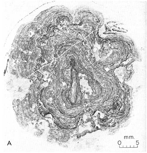
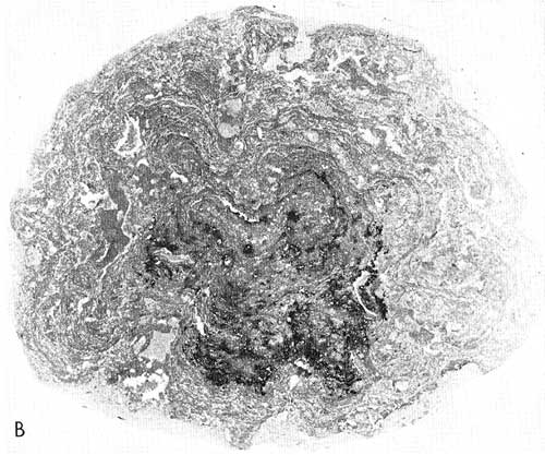
Figure 4--Sappington fauna. Illustrations 1-12, 14-17 are from the algae-sponge biostrome unit E. 1-12, Arenaceous Foraminifera from HCl residues of oncolites, Antelope Valley Locality no. 7; 1, 2, and 4, ammodiscids, 3, tolypamminid, 5-11, hyperamminids, 12, reophacid. 13, 19, and 20, Bifungites fezzanensis Desio, burrow of wormlike organism. Note circular tubular burrow fillings normal to bedding on barbs of arrows and also on ripple-marked bedding surface. 20, Association of burrows and sole markings on bottom of bed. 14 and 15, Spongiostromatid algal nodules. 14, Exterior of single nodule from the Bridger Mountains. 15, Natural weathered cross section showing brachiopod nucleus and wavy concentric growth layers, Antelope Valley Locality no. 7. 16 and 17, Calcareous sponge and cross section showing canal structure through wall, Milligan Creek Locality no. 1. 18, Scalarituba from the Beaver Creek Locality no. 11. Scale for figures 1-12 X 35, all others X 2/3. A larger version of this figure is available.
The nodules are regarded as algal in origin and oncolites in form. Encrusting algae grew on the brachiopod shells and eventually enveloped the valves as currents turned them over and over. Adnascent organisms also grew on the nodules to be covered in time by the growing algae. The oncolites enlarged in this manner up to pebble and small cobble size. They accumulated in profusion in very shallow water over the extensive shelf area; and at times may have been exposed to the air. Other animals are found in the matrix between nodules. This remarkable biostrome was eventually stifled by an influx of silt and clay. It should be emphasized that the nodules described above for this unit are quite different than the water reworked nodules found in the upper shale of the Three Forks Formation.
Lower Siltstone Unit (F)--This unit is variable in lithology and consists predominantly of calcareous, shaly siltstone and silty shales. Impure limestones also occur. The fresh rock is medium gray but weathers to yellow-orange color. The unit is more resistant to weathering than the overlying slope forming shale; consequently, it forms a topographic riser with nonuniform outward projection of alternating recessive shales and ledgy siltstones. It is gradational in contact with the underlying nodular beds of unit E. Local thin bioclastic layers and lenses consisting primarily of crinoid hash occur in the lower part of the unit, and brachiopods are common in the uppermost layers. Brachiopods and crinoid stems are sparsely scattered throughout the unit, but their preservation is generally poor. Ripple marks, channel-fill structures, and animal burrows are also present.
The unit represents an influx of fine clastics into and over the algal-sponge biostrome with fairly sharp change to mud and silt tidal flats. Occasional surges of marine waters brought in crinoid debris and also helped to develop the brachiopod bed; otherwise, conditions were unfavorable for normal marine faunas. The fine clastics and their sedimentary structures represent marginal encroachment of alluvial sediments onto the tidal flat or embayment. Channel sandstones represent deltaic distributaries and drainage outlets on the tidal flat. The ripple-mark pattern indicates extensive wind-swept shallow water areas and possibly reflects depositional strike of the sediments.
Middle Shale Unit (G)--This unit is a dark greenish-gray, laminated, calcareous shale with vertical cylindrical silt tubes and thin (less than 1/2 inch) irregular lenticular silt laminations. It forms a conspicuous slope between the underlying and overlying siltstone units. It is characterized by animal burrows (worms) and arrowhead markings of Bifungites fezzanensis Desio which are abundant in the upper part. There is a channel-fill siltstone in the Antelope Valley section which contains blastoid plates, crinoids, conchostracans, ostracodes, brachiopods, clams, conodonts, echinoid spines, microcrinoids, bryozoans, and worms (?).
Silt deposition of the previous unit gradually changed to mud-flat environment in which wormlike animals lived and burrowed into the sediments. They made circular vertical tubes and lateral galleries which later became filled with fine silt and compacted into interlaminated shale and silt. The facies is very similar to that described and illustrated by Christopher (1961, Fig. 25). Some siltshale contact bedding surfaces have the arrowhead markings of Bifungites which are interpreted as worm (?) burrows in the underlying mud substratum in U-shaped tubes with arrowshaped grooves on the mud surface by the animal. The groove and tubes became filled with silt of the overlying bed and lithified. When the siltstone layers are broken out and split from the shale, the arrowlike markings appear as molds on the undersurface with the cylindrical tubes at either end broken off. The tubular silt fill remains in the shale. It is interesting that this form was first described from Late Devonian sediments of Libya. (Desio, 1940).
Upper Siltstone Unit (H)--The upper siltstone unit usually forms the best exposed portion of the Sappington since it is part of a cliff-forming sequence continuous with the overlying Lodgepole Limestone. Lithologically it consists of pale yellow-orange, slightly calcareous, flaggy to massive siltstone and fine sandstone which has many small scale sedimentary structures. Fossils are very scarce except for burrows. Brachiopods have been found at the base of the unit at Beaver Creek, but these may represent a small channel-fill occurrence. Ripple marks, channel fills, flow rolls, cross stratification, sole markings, tubular burrows and arrowheads, and segmented vermicular markings are common. Eastern sections have the massive cliff-forming siltstone developed; however, western sections have greater alternation of silty shales and abundant channel-fill sandstone lenses, so that change from units G to H is gradational.
There are sharp changes in sedimentation between the upper Sappington siltstone (unit H), dark silty shales of unit I, and the lower Lodgepole Limestone beds (unit J). The time represented by this change is of short duration; however, truncation does occur in the western sections where the dark shales are absent. In the Sappington type area flow rolls at the top of the upper siltstone unit are truncated, and Lodgepole Limestone rests directly on the bevelled edges of the rolls.
Eastern sections have the upper dark shales present (unit I). They are dark gray, silty, micaceous, and granular containing conodonts, spores, brachiopods (inarticulate), and fish remains. There are also usually two siltstone beds that occur in the upper part of the shale sequence which contain Zoophycus (Taonurus) in various orientations throughout the beds.
The upper dark shales during the past few years have been included with the Sappington Formation by several authors; however, recently Sandberg and McMannis (personal communication, September, 1962) concur that they are basal to the Lodgepole Limestone and should be included with it. Sandberg indicates that the shales are well developed to the east and overlap the Sappington and older rocks from that direction. According to Gilbert Klapper (personal communication) they contain an Upper Devonian (to V)-Lower Carboniferous (cu I) conodont fauna. Accordingly, the contact between the Sappington and Lodgepole is regarded as the top of the upper siltstone unit.
Following offlap and erosional bevelling of the upper Sappington, restricted water conditions prevailed during deposition of the upper dark shales and siltstones under reducing conditions. Abrupt changes brought about by a transgressive sea produced open shelf environments for marine Lodgepole Limestone deposition. Rocks and fossils of unit J indicate that they were deposited above wave base to be followed by unit K which is believed to be formed below wave base.
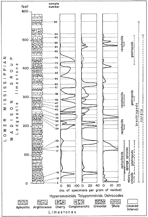
Studies are now being made of the environmental sequence in the Madison Group of southwestern Montana. Preliminary studies of the Lodgepole Limestone section at Logan, Montana, have indicated cyclical deposition as has been suggested by Holland (1952), Laudon and Severson (1953), and others. This is indicated by the distribution of microfaunas in the Lodgepole and the repetitious alternating succession of limestones and calcareous shales with their associated facies fossils. A preliminary chart is included to show the vertical distribution of Lodgepole microfaunas extracted from hydrochloric acid residues (Fig. 5). More study is needed to fully understand the pattern.
Figure 5--Faunal distribution within Lodgepole Limestone at Logan, Montana, based upon hydrochloric acid residues.
Detailed measured sections have been made at the following places which represent the most complete and best exposed sections on which the interpretations are based. All are in western Montana with the exception of the Leatham Hollow section which is in Utah.
1. Milligan Creek section, NW sec. 36, T. 2 N., R. 1 W., Three Forks Quadrangle, Jefferson County (Berry's type locality of the Sappington; Berry, 1943).
2. Logan section (Montana), S2 sec. 25, T. 2 N., R. 2 E., Manhattan Quadrangle, Gallatin County (Holland's type section of the Madison Group).
3. Leatham Hollow section, NW sec. 34, T. 11. N., R. 2 E., Logan Quadrangle, Cache County, Utah (Holland's type section of the Leatham Formation).
4. East Milligan section, SW sec. 31, T. 2 N., R. 1 E., Three Forks Quadrangle, Broadwater County.
5. Brown Back Gulch section, SW sec. 20, T. 1 S., R. 3 W., Madison County.
6. Red Hill section, SE sec. 22, T. 2 N., R. 3 W., Jefferson Island Quadrangle, Jefferson County.
7. Antelope Valley section, NE sec. 2, T. 1 S., R. 2 W., Jefferson Island Quadrangle, Madison County.
8. Nixon Gulch section, SE sec. 14, T. 2 N., R. 3 E., Manhattan Quadrangle, Gallatin County.
9. Bighorn Lake section, SE sec. 14, T. 2 N., R. 6 E., Sedan Quadrangle, Bridger Mountains, Gallatin County.
10. Sixteen Mile Creek section, CSL sec. 4, T. 4 N., R. 3 E., Toston Quadrangle, Broadwater County.
11. Beaver Creek section, NW sec. 32, T. 13 N., R. 1 W., Lewis and Clark County.
12. North Sawtooth Mountain section, NE sec. 13, T. 21 N., R. 9 W., Sawtooth Ridge Quadrangle, Lewis and Clark County.
Berry, G. W., 1943, Stratigraphy and structure at Three Forks, Montana: Geol. Soc. America Bull., v. 54, p. 1-30.
Christopher, J. E., 1961, Transitional Devonian.Mississippian formations of southern Saskatchewan: Saskatchewan Dept. Min. Res. Rept., no. 66, 103 p.
Desio, Ardito, 1940, Vestigia Problematiche Paleozoiche della Libia: Annali del Museo Libico di Storia Naturale, v. 11.3, p. 47.92.
Gutschick, R. C., Suttner, L. J., and Switek, M. J., 1962, Biostratigraphy of transitional Devonian-Mississippian Sappington Formation of southwest Montana: Billings Geol. Soc. 13th Ann. Field Conf. Guidebook, p. 79-89.
Holland, F. D., Jr., 1952, Stratigraphic details of lower Mississippian rocks of northeastern Utah and south. western Montana: Am. Assoc. Petroleum Geologists Bull., v. 36, p. 1697-1734.
Laudon, L. R., and Severson, J. L., 1953, New crinoid fauna, Mississippian, Lodgepole Formation, Montana: Jour. Paleontology, v. 27, p. 505-536.
McMannis, W. J., 1962, Devonian stratigraphy between Three Forks, Montana and Yellowstone Park: Billings GeoL Soc. 13th Ann. Field Conf. Guidebook, p. 4-11.
Pepper, J. F., DeWitt, Wallace, and Demarest, D. F., 1954, Geology of the Bedford Shale and Berea Sandstone in the Appalachian Basin: U. S. GeoL Survey Prof. Paper 259, 109 p.