 |
|
Kansas Geological Survey Open-file Report 2003-82 |
5.3 Depositional Models
Cherokee Group coals accumulated in a variety of depositional settings including, marshes, open and back barrier coastlines, estuaries, and fluvial flood basins. Pre-existing topography coupled with relative position within a systems tract, played a major role in the growth, distribution and quality of Pennsylvanian peatlands that eventually develop into coal. Interpretations of depositional environments and controls on peat development are primarily based on isopach map interpretations (Chapter Two), relation to underlying and overlying stratigraphy (Chapter Two) and proximate analysis (Chapter Three). A brief description of depositional orientation, average thickness and geometry of coal beds used for interpretations of depositional environments and controls on peat development are summarized in Table 5.1.
Coal Unit |
Orientation |
Average Thickness (ft) |
Geometry |
Depositional Setting or Control |
| Summit | Dip & Strike | 1.0 | Thin, circular | Topography |
| Mulky | Dip & Strike | 0.75 | Thin, circular | Topography |
| Iron Post | Dip | 1.0 | Thin, elongate | Fluvial Floodbasin |
| Bevier | Strike | 1.5 | Thin, lenticular | Coast Plain |
| Croweburg | Strike | 1.0 | Thin, lenticular | Coast Plain |
| Fleming | Dip | 1.0 | Thin, dendritic | Estuarine |
| Mineral | Strike | 1.5 | Thin, lenticular | Coast Plain |
| Scammon | Dip | 1.0 | Thin, dendritic | Estuarine |
| Tebo | Dip | 0.9 | Thin, elongate | Fluvial Floodbasin |
| Weir-Pitt. | Strike | 1.5 | Thin, lenticular | Coast Plain |
| Aw | Dip | 1.7 | Thin, elongate | Fluvial Floodbasin |
| Riverton | Dip & Strike | 1.8 | Thin, lenticular | Pre-Penn. Topography |
Table 5.1 – Interpretations for Cherokee Group coal depositional settings and controls according to depositional orientation, average thickness, and geometry (approach is modified from Flores, 1993).
5.3.1 Abrupt Marine Regression
Several times through the Middle Pennsylvanian in southeast Kansas coal beds
are found directly above fossiliferous marine limestones or shales with little
or no underlying paleosol development. When present, the clay (paleosol) overlying
the limestone may have either accumulated during the marine regression or
be non-marine in origin. It would appear that these Cherokee Group coals formed
after an abrupt regression on extensive low-lying plains (Wanless, 1969).
Examples include the Mulky coal situated above the Breezy Hill Limestone of
the Cherokee Group, and the Summit coal located above the Blackjack Creek
Limestone of the Fort Scott. The limestone formed in a relatively shallow
sea with a moderately smooth floor (Wanless, 1969). However, small-scale topographic
highs on the sea floor provided areas that submerged earlier than the rest
of the sea floor, creating a favorable surface for initiation of peat accumulation.
The Mulky and Summit coals tend to be highly variable in thickness and show
thin, circular geometries as the coals thicken onto structural highs (Figures
2.32, 2.33). Variation in thickness appears related to subtle changes in topography.
It appears that shallower areas emerge and peat swamps initiate prior to the
peat swamps that formed in deeper areas (Figure 5.01). The initial formation
of a peat hammock would form a freshwater lens due to the topography followed
by enhancement of the lens through enhancement of topographic relief (Spackman
et al., 1969). Proximate analysis indicates that the Mulky and Summit coals
tend to be carbonaceous shale or high-ash coal rather than a pure coal. The
Mulky and Summit coals have ash contents that range from 36.3 to 88.8 percent
and sulfur contents that are greater than 11 percent. The close association
with marine carbonate sediments and low relief can explain the high-ash, high-sulfur
and carbonaceous nature of the coal (Figure 5.01). Continued peat growth in
topographic lows subject to periodic invasion by admixed marine mud results
in carbonaceous shale, or high-ash, and sulfur-rich coals. It appears that
the better quality low-ash and thickest coal develops in mires on topographic
highs more protected from the marine influence. The influence of topography
and relative marine influence are themes throughout deposition of the Cherokee
Group coals.
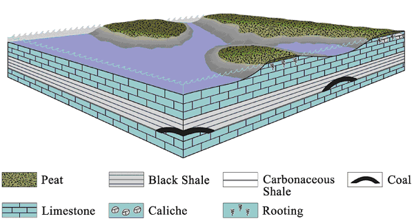 |
| Figure 5.01 - Depositional model for peatland development above regressive marine carbonates. Variation in coal thickness may be due to subtle changes in topography, where shallower areas that submerge before deeper areas are conducive to peat development. |
5.3.2 Fluvial Floodbasin
Distribution of peatlands associated with fluvial flood basins increase in thickness and abundance away from fluvial axes. Detritus decreases away from fluvial axes except when detritus is transported by crevasses splays and overbank processes (Flores, 1993; Figure 5.02). Coal beds formed from peatlands in the above setting are commonly interbedded with marine to marginal marine coarsening upward mudstones, siltstones and sandstones, fining-upward fluvial channel sandstones, coarsening-upward crevasse-splay mudstones, siltstones, and sandstones, and thin lacustrine deposits (McCabe, 1991; Flores, 1993). Geometry of coal beds in this setting vary from dendritic, elongate, lens, and lenticular along depositional dip (Flores, 1993). Coal adjacent to channels that are thin and or contain splits, suggests contemporaneous channel and peat development (McCabe, 1991).
Laterally extensive although discontinuous, thin, elongate, and dendritic coals such as the Iron Post, Tebo, and Aw coals are interpreted to have formed in an associated fluvial floodbasin setting. Many other local and informally known coals may have also formed in settings similar to that of the Iron Post, Tebo, and Aw. The ash content of coals in floodbasin sediments can be highly variably depending on the amount of detritus transported into the peatland. In the Cherokee basin, coals interpreted as deposited in floodbasin settings have between 11.4 and 64.7 percent ash. Presumably the range in ash content is also a reflection from the type of mire.
Raised and low-lying mires have been suggested as an explanation of differences
between ash contents of coals (McCabe and Shanley, 1992). Sulfur contents
are typically less than 4 percent due to the decreased marine influence.
 |
| Figure 5.02 - Depositional model for peatland development associated with fluvial systems. Coals that develop from peatlands in fluvial systems tend to thicken away from channels and split toward channels. Areas of peatlands are removed by fire splays, crevasse splays or eroded by fluvial incision. |
5.3.3 Estuarine
Several times throughout deposition of the Cherokee Group, relative sea level dropped, resulting in fluvial incision. Remnants of this process are indicated by several mappable, fluvially eroded, elongate topographic lows that are typically larger than any one single channel form. These features are known as incised valleys (Zaitlin et al., 1994). During sea level rise, incised valleys are filled with fluvial sands, estuarine sands, and shelf muds (Zaitlin et al., 1994; Figure 5.03). As for relation to peat accumulation, the inner incised valley where the bay head delta is formed is the most important. With a continued transgression, stream gradient and capacity decreases, and freshwater organic facies increase in abundance on less mature soils of the upper estuary (Zaitlin et al., 1994; Figure 5.03).
In the mid-continent several Middle Pennsylvanian coals have been interpreted as developing in estuaries prior to drowning (Wanless, 1969). Coals associated with estuarine environments are described as occupying linear troughs that range from less than 1.5 miles (2.4 km) up to more than 4 miles (6.4 km) in width and have thin dendritic geometries (Wanless, 1969 and; Flores 1993). Discontinuous, thin and dendritic coals, such as the Fleming coal, Scammon coal, and several informally known coals are interpreted to have formed in association with upper estuarine environments. The previously mentioned coals are also closely associated with lithofacies that are interpreted as bay head delta and central bay sediments (Chapter Two). The ash content of coals in estuarine strata is relatively high (30 percent +/-) due to the input of clastic material brought into the upper estuary by the fluvial system. Sulfur content of 6 percent is also relatively high due to the marine influence up into the estuarine system.
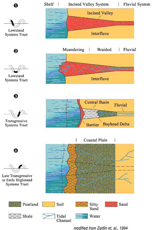 |
| Figure 5.03 - Depositional model for peatland development in estuarine systems. Thin, locally developed coals are interpreted to have formed from peatlands constrained within estuarine valleys (3). After flooding of an estuarine valley, coastal plains and extensive peatlands will develop over top of the valley (4) |
5.3.4 Coastal Plain
Peatlands in coastal plains develop above and behind open and back barrier shorelines, on estuaries, above infilled lagoons, and atop interfluves (Flores, 1993; Figures 5.03, 5.04). Back-barrier coals are generally laterally continuous and parallel to depositional strike (Wanless, 1969; Flores, 1993). Sustained growth and preservation of peat requires protection from marine influence. A gradual increase of base level will raise the water table aiding in the growth of mires. Continued transgression will lead to aggradation and eventually marine rocks bury the peatlands. In addition barred or stationary shorelines aid in the protection of peatlands from marine processes.
Coals such as the Bevier, Croweburg, Mineral, and Weir-Pittsburg have lenticular
geometries oriented parallel to depositional strike and suggest peatland development
on coastal plains. Average thickness of coastal plain coals is approximately
1.5 ft (0.5 m) with a normal distribution in thickness (Appendix 2). The scale
of coastal coal development in the Cherokee basin is similar to peatland development
described from coastal plains of the Malay Peninsula (Coleman et al., 1970).
The ash content of coals interpreted, as coastal plain deposits is relatively
low compared to other Cherokee basin coals. Cherokee Group coals associated
with the coastal plain have ash contents between 19.5 and 32.7 percent. Sulfur
contents are also relatively low, ranging from 1.9 to 3.6 percent, which suggests
some protection from marine influence during coalification.
Topographic relief of the mire also plays a significant role in the development
of peat. Low-lying peatlands are prone to tidal effects and form brackish
mires, while fresh water peatlands form in elevated areas with high precipitation
and migrate across the low-lying mires to form protected raised mires (Flores,
1993; McCabe, 1991; Figure 5.04). Tidal channels, estuaries, and short-headed
streams, form drainage systems for peatlands peatlands on coastal plains (Coleman
et al., 1970).
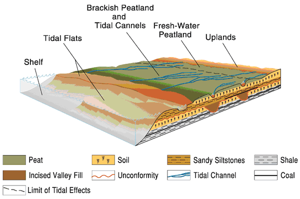 |
| Figure 5.04 - Depositional model for peatland development associated with coastal plains. Low-lying peatlands are prone to tidal effects and from brackish mires, while fresh water peatlands form in elevated areas and migrate across the low-lying mires to form protected raised mires. |
5.3.5 Pre-Pennsylvanian Topography
Topographic relief up to 300 feet (91.5 m) existed on the karsted limestone terrain in the central United States prior to deposition of Pennsylvanian sediments (Siever, 1951). As a result, initial Pennsylvanian sedimentation occurred in erosional valleys created by karstification. The karst topography on top of the Mississippian limestones provided many low-lying areas where lakes and marshes developed (Figure 5.05). During the initial Pennsylvanian transgression, low-lying mires formed across topographic lows as the water table rose. Raised mires developed above the low-lying mires (McCabe, 1991). Given sufficient precipitation raised mires can sustain their water table while building upward (McCabe, 1991; Figure 5.05). Margins of raised mires are typically steep and eventually pinch out into clastic sediments of marginal marine environments. The presence of marine deposits directly above the Riverton coal suggests that a transgression eventually drowned and buried the peatlands. Burial, compaction and coal formation can reduce coal thickness to less than 10 percent of original peat thickness and result in coals that appear to pinch out onto paleotopographic highs (Mukhopadhyay and Hatcher, 1993; Figure 5.05).
Coals such as the Riverton and informally known Riverton A-D coals will tend to thicken into Mississippian lows where peat developed from both raised and low-lying mires (Figure 5.05). Evidence of this relationship is indicated in the Riverton coal isopach map of Figure 2.16, and was observed at the outcrop scale of the Riverton coal in a sinkhole at the Sunflower lead-zinc mine in Cherokee County, Kansas (Figure 5.06). Ash contents of coals developed in this setting range from 7.3 to 35 percent, and sulfur contents are also highly variable and range from 2.8 to 10.7 percent. Variability in ash content is likely due to differences in peat development between raised and low-lying mires, and the relative influence of marine waters during coal formation. During coal formation, influx of marine water can result in a significant pyrite formation and relatively high sulfur content (> 5 %). Other early Cherokee Group coals (eg. Krebs Formation) have depositional patterns influenced by the topographic irregularities on top of the Mississippian limestones (Wanless, 1969).
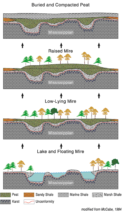 |
| Figure 5.05 - Depositional model for peat development influenced by pre-Pennsylvanian topography. The karst topography on top of the Mississippian limestones provided many low-lying areas where lakes and marshes developed and subsequent peatlands. As a result, Riverton coals tend to thicken into Mississippian lows where peat developed from both raised and low-lying mires. |
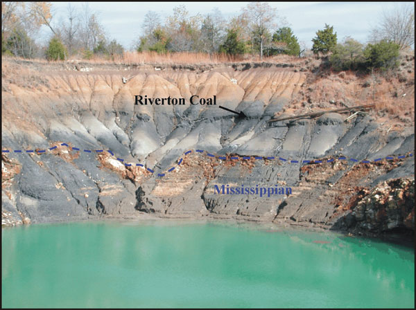 |
| Figure 5.06 - Sink hole at Sunflower Pb-Zn mine in Cherokee County, Kansas: SW 10-T35S-R24E. Note the Riverton coal thickening into Mississippian lows. |
e-mail : webadmin@kgs.ku.edu
Last updated December 2003
http://www.kgs.ku.edu/PRS/publication/2003/ofr2003-82/chapter5_2.html