 |
|
Kansas Geological Survey Open-file Report 2003-82 |
4.2 Identification of Sequences and Systems Tracts
Sequences are separated by sequence boundaries, which form in response to falls in base level (Van Wagoner et al., 1990). Sequence boundaries are laterally continuous, correlatable over at least the basin scale, and appear within the limits of chronostratigraphic resolution to be synchronous in many basins around the world (Vail et al., 1977). One or more of the following must be established over at least a basin scale to define a sequence boundary:
- subaerial-erosional truncation and laterally equivalent subaerial exposure surfaces and down-dip submarine-erosion;
- coastal onlap;
- downward shift in coastal onlap (Van Wagoner et al., 1990).
In this study, the base of incised valleys and laterally equivalent subaerial erosion on interfluves are interpreted as sequence boundaries.
Within the study area, seven sequences were defined within the Cherokee Group (Figures 4.01, 4.02 in packet, 4.03). Utilization of closed loop well-log cross sections aided in determining incised valley geometries. Core analysis tied to the well log response provided criteria to recognize laterally equivalent well developed soil or root horizons (paleosols) interpreted as interfluves (Figures 4.04-4.10). The widespread features of erosion and subaerial exposure recognized and mapped in the Cherokee Group are interpreted as sequence boundaries.
4.2.2 Incised Valleys
An incised valley is a low, elongated, paleotopographic feature that formed as result of a fall in sea level and the erosion of an exposed shelf by fluvial processes (Van Wagoner et al., 1988). Incised valleys are generally characterized by the following;
- incised valleys commonly are aligned and tend to increase in dimension down-valley;
- the walls and the bases of the incised valleys are bound by sequence boundaries that may be correlated to subaerially erosional surfaces (paleosol, interfluve);
- incised valleys are larger and deeper (with a width/thickness ratio of 1/1000) than individual channels (with a width/thickness ratio of 1/100) and have valley-like features;
- incised valley incisions take the form of terraces;
- within an incised valley, basinward shifts in facies are present across a sequence boundary;
- the fill of an incised valley records a trend of increasing accommodation space (sea level rise) and an onlap relationship with the valley walls
(Van Wagoner et al., 1988; Zaitlin et al., 1994).
As the sea level rises, an incised valley is converted into a drowned river-mouth estuary and the valley fill begins to accumulate. The drowned valley receives sediment from two major sources: from the land via a river and from the sea via wave and tidal currents, longshore drifts, and storms. The balance between the rate of the relative rise in sea level and the volume of sediment input from both sides control the type and the geometry of the valley fill (Nichols and Biggs, 1985). Therefore, an incised valley can be filled completely or partially with fluvial sediments or with open marine sediment (Allen and Posamentier, 1993). However, estuarine deposits are the most common fill of drowned valleys (Allen and Posamentier, 1993).
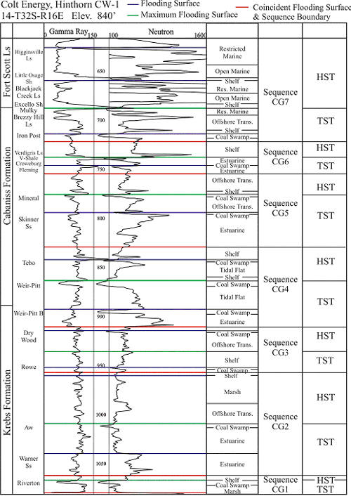 |
| Figure 4.03 - Well log expression of sequence stratigraphy in the Colt CW-1, Montgomery County, Kansas |
4.2.3 Estuaries
An estuarine setting can contain any number of the following environments: braided, meandering, tidal flat, back barrier island, tidal channel complex, bay-head delta, and shoreface environments. The degree of preservation and the dominance of both marine and fluvial facies within an estuary environment are mainly controlled by the rate of the rise in sea level, the intensity of wave and tidal currents, and fluvial discharges of sediment (Allen and Posamentier, 1993).
Estuarine environments are characterized by fluctuations in salinity, fluctuations in current energy, increasing accommodation space, and landward transgression of marine facies. Fluctuations in salinity (marine-brackish-fresh water) can be inferred from the following: (1) an increase of ichnofauna size, abundance and diversity seaward; (2) an alternation of pyrite, siderite and glauconite intervals; (3) a seaward increase in bioturbation; (4) the presence of coal and carbonaceous material; and (5) a seaward increase in bioclastic diversity and size (Zaitlin et al., 1994). Fluctuations in current energy can be inferred from a combination of the following: (1) an alternation between high-energy (unidirectional or bi-directional cross-bedding) and low-energy sedimentary structures (characterized by ripple marks and mud drapes); (2) interbedding of highly bioturbated and unbioturbated intervals; and (3) the presence of fining upward intervals (Zaitlin et al., 1994).
The interlaminated sandstone and siltstone facies and sideritic gray shale facies (described in Chapter 2) are interpreted as being part of estuarine incised valley fills. This conclusion is based on core observations in facies transitions, sedimentary structures, abundance and diversity of ichonofauna, and the identification of facies that appear to fill above incision surfaces, which exhibit elongate and linear trends. In this study, the interlaminated sandstone and siltstone facies is interpreted as channel fills of a bay-head delta (upper estuarine) and the overlying sideritic gray shale facies is interpreted as being formed in a central basin (inner estuarine) of an estuary.
4.2.4 Systems Tracts
Sequences can be subdivided into systems tracts based on types of bounding surfaces, position within a sequence, parasequences set-stacking patterns, geometry, and facies associations (Van Wagoner et al, 1988). In this study, lowstand (LST), transgressive (TST) and highstand systems tract (HST) are used to partition sequences. The lowstand systems tract forms during a significant sea-level fall that results in extensive subaerial exposure and/or widespread fluvial incision (thick paleosol and/or incised valley respectively). Lowstand systems tracts are bounded by a sequence boundary and by the first major marine flooding surface (FS). Since fluvial deposits were not observed at the base of incised valleys within the Cherokee Group, a lowstand systems tract was not identified in any of the sequences of this study. Fluvial deposits however, have been interpreted further north and up depositional dip from the Cherokee basin in the Cherokee Group (Cole, 1969; Visher et al., 1971). Transgressive systems tracts are bounded at the base by the first major marine flooding surface, and at the top by the maximum flooding surface (MFS). Maximum flooding surfaces are indicative of regional development of a condensed section consisting of hemipelagic or pelagic sediments (Posamentier and Allen, 1999). In this study, maximum flooding surfaces are picked on the highest gamma-ray values within a sequence (API). The highest gamma-ray values provide for a consistent marker, and appear to be linked to condensed section development during maximum flooding. The phosphatic black shale facies (“core shale”) described from the Cherokee Group are considered to be at or near a maximum flooding surface (Walton, 1995). The highstand systems tract is bounded at the base by the maximum flooding surface and at the top by the overlying sequence boundary (Van Wagoner et al., 1990).
4.2.5 Sequence CG1
Sequence Cherokee Group 1 (CG1) is distributed over the entire study area and contains the Riverton shale and coal, along with many thin underlying local coals (Figures 4.01, 4.02). A surface of subaerial exposure on the top of the Mississippian Warsaw Limestone (Meremecian) is the basal boundary of sequence CG1 (Figures 4.03 and 4.04). The top Mississippian limestones exhibit extensive paleokarst features, which are unconformably overlain by Middle Pennsylvanian siliciclastics (Watney et al., 2001). A marine flooding surface is coincident with the basal sequence boundary, where marginal marine shales and coastal marshes overlie the top Mississippian limestones (Figure 4.04). The widespread presence of marginal marine deposits suggests that sequence CG1 begins in the transgressive systems tract, while the lowstand systems tract was not preserved in the sequence.
A regionally extensive, high gamma-ray black shale overlies the Riverton coal, informally known as the “Riverton shale,” marks the maximum flooding surface (MFS) and transition into the highstand systems tract (Figure 4.04). Progressing up through the transgressive systems tract, coals beds are thin and highly discontinuous until reaching the first thick and laterally continuous coal bed (i.e. Riverton coal; and 4.02). The highstand systems tract of CG1 is characterized by a few thin unnamed local coals, and offshore transitional environments (Figures 4.01 and 4.02). In CG1, only the Riverton coal is of sufficient thickness, continuity, and quality (high organic content, low ash, high Btu/lb) to be a target for coalbed gas development in southeast Kansas.Figures 4.01.
Sequence Cherokee Group 1 and 2 |
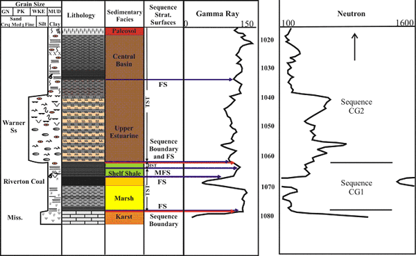 |
| Figure 4.04 - Sequence stratigraphic log characteristics of Cherokee Group sequence 1 and 2, based on core and well log from the Hinthorn CW#1 well, 14-T32S-R16E, Montgomery County, Kansas (scale in feet). See Figure 2.15a for legend. |
4.2.6 Sequence CG2
Sequence Cherokee Group 2 (CG2), is correlated over the entire study area and contains the informally known Aw, Bw, Cw, and Dw coals and the sporadically distributed Warner Sandstone (Figures 4.01, 4.02). A surface of erosion at the base of the Warner Sandstone is the basal boundary for sequence CG2 (Figures 4.03 and 4.04). Erosional indicators are based on cross-sections that illustrate incised valley geometries, and core observations of the transition from sequence CG1 offshore deposits (HST) to estuarine environments or a thick paleosol (Figure 4.01 and 4.02). The widespread presence of marginal marine deposits at the base of sequence CG2 suggests that the sequence begins in the transgressive systems tract, where a marine flooding surface is coincident with the basal boundary of the sequence.
The A-B shale marker just above the Aw coal is interpreted as being the maximum flooding surface (MFS) of sequence CG2 due to its higher gamma-ray value than other shales in the sequence (Figure 4.03). The transgressive systems tract is characterized by an estuarine incised valley fill, including the marginal marine environments of the Warner Sandstone, and thin, highly discontinuous coals beds such as the Cw and Dw (Figures 4.01 and 4.02). The thicker and laterally extensive Aw and Bw coals are part of the upper transgressive systems tract. The highstand systems tract consists of a shoaling-upward sequence manifested by shelf to coastal marsh environments. In this study there are no coal beds observed within the highstand systems tract of sequence CG2. Coals in sequence CG2 in southeast Kansas have not been significant targets for coalbed gas development due to lack of continuity. However, the Aw and Bw coals may have the potential for coal gas development due to relative thickness and higher gas saturations than other coals in sequence CG2.
4.2.7 Sequence CG3
Sequence Cherokee Group 3 (CG3), is distributed over the entire study area, and contains the Dry Wood coal, Rowe coal, Neutral coal, and upper Warner Sandstone (Figures 4.01, 4.02). Although the upper Warner Sandstone was not recognized in sampled cores, it is recognized in numerous well logs. The log response of the upper Warner Sandstone is similar to the log response of the lower Warner Sandstone (Figures 4.03 and 4.04). The base of an incised valley was identified by cross section geometry starting at the base of the upper Warner Sandstone, which is interpreted as the basal boundary for sequence CG2. A marine flooding surface is interpreted to be coincident with the basal boundary of Sequence CG3 due to marginal marine deposits observed in cores (Figure 4.03).
The maximum flooding surface (MFS), approximately 20 feet (6.1 m) above the Rowe coal, was picked on the highest gamma-ray values in sequence CG3 (Figure 4.03). Shelf deposits, and thin, regionally semi-continuous coals such as the Rowe and Neutral are part of the transgressive systems tract (Figures 4.01 and 4.02). Highstand systems tract deposits are characterized by a shoaling-upward sequence of offshore to marginal marine environments. A thin and laterally discontinuous coal (i.e., Dry Wood) is located within the highstand systems tract of sequence CG3. The discontinuous nature of the Dry Wood coal is partially the result of erosion by deep incision of the overlying sequence. The Rowe coal is a major target for coalbed gas development to the south in Oklahoma. Although the Rowe is not as well developed or continuous in the Cherokee basin, it is starting to become a more significant coalbed gas target in southeast Kansas due to relatively high gas contents (Jim Stegeman, Colt Energy, personal communication, 2003).
4.2.8 Sequence CG4
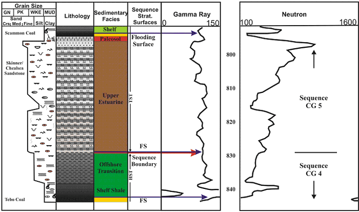
Sequence Cherokee Group 4 (CG4), is distributed over the entire study area and contains the Tebo coal, Weir-Pittsburg coal, Weir-Pittsburg B coal, informally known Tebo B, Abj, Bbj, Cbj, and Dbj coals, along with the Bluejacket Sandstone or informally known Bartlesville sandstone (Figures 4.01, 4.02). Incised valley geometries identified in cross-section are interpreted as the basal boundary for sequence CG4 (Figure 4.05). In addition, cores show an upward transition from offshore deposits of the HST of sequence CG3 to estuarine environments, and an erosional surface or a thick paleosol at the base of CG4 (Figure 4.05). The presence of marginal marine deposits at the base of the sequence indicates that a flooding surface is coincident with the basal boundary of sequence CG4 (Figure 4.03).
Immediately above the Weir-Pittsburg coal, a regionally extensive black “core
shale” (informally known as the Weir-Pittsburg shale) marks the maximum
flooding surface (MFS) and transition into the highstand systems tract (Figure
4.05). Progressing up through the transgressive systems tract, environments
range from marginal marine estuarine incised valley fill to muddy tidal flats.
Coals beds, such as the Abj, Bbj, Cbj, and Dbj, are thin and highly discontinuous
until the appearance of the Weir-Pittsburg coal. The Weir-Pittsburg coal is
just below the maximum flooding surface and is one of the thickest and laterally
extensive coals in the Cherokee Group. The highstand systems tract consists
of two shoaling-upward successions from shelf to marginal marine environments.
Within this HST, the Tebo coal is thin but fairly continuous, and the underlying
“Tebo B” coal occurs sporadically (Figure 4.06). In CG4, the Weir-Pittsburg
coal is of sufficient thickness, continuity, and quality (high organic content,
low ash, low sulfur, high Btu/lb) to be a primary target for coalbed gas development
in southeast Kansas.
Sequence Cherokee Group 4 |
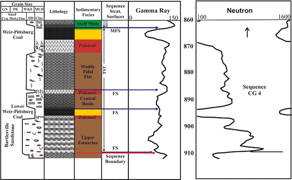 |
| Figure 4.05 - Sequence stratigraphic log characteristics of Cherokee Group sequence 4, based on core and well log from the Hinthorn CW#1 well, 14-T32S-R16E, Montgomery County, Kansas (scale in feet). See Figure 2.15a for legend. |
4.2.9 Sequence CG5
Sequence Cherokee Group 5 (CG5), is distributed over the entire study area, and contains the Mineral, Scammon, and “Scammon B” coals along with the Chelsea Sandstone or informally known Skinner sandstone (Figures 4.01, 4.02). A basinward shift in facies at the base of the Chelsea or Skinner observed in cores is interpreted as the basal boundary for sequence CG5 (Figure 4.03 and 4.07). Lithofacies transitions and erosional surfaces are observed in cores throughout the study area that are indicated by the shift from HST offshore deposits in CG4 to estuarine environments or a thick paleosol at the base of sequence CG5 (Figure 4.07). Additionally, incised valley geometries are identified in cross-section (Figure 4.01). Marginal marine deposits observed in cores at the base of sequence CG5 suggest that a marine flooding surface is coincident with the basal boundary of the sequence.
A regionally extensive phosphatic black shale above the Mineral coal, informally known as the Mineral shale has the highest gamma-ray values within the sequence, which marks the maximum flooding surface and transition into the highstand systems tract (Figure 4.08). Moving up through the transgressive systems tract, environments range from shelf to marginal marine with estuarine incised valley fill. Coals beds in the lower TST of CG 5, such as the “Scammon B” and Scammon, are thin and highly discontinuous (Figures 4.01, 4.02 and 4.07). The Mineral coal is relatively thicker than other CG5 coals and is laterally continuous across the study area (Figure 4.01 and 4.02). The highstand systems tract consists of shelf to offshore transition deposits with no identified coals. In CG5, only the Mineral coal is of sufficient thickness, continuity, and quality (high organic content, low ash, low sulfur, high Btu/lb) to be a target for coalbed gas development in southeastern Kansas.
Sequence Cherokee Group 4 |
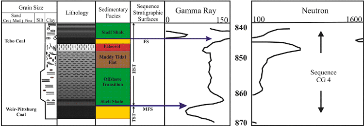 |
| Figure 4.06 - Sequence stratigraphic log characteristics of Cherokee Group 4, based on core and well log from the Hinthorn CW#1 well, 14-T32S-R16E, Montgomery County, Kansas (scale in feet). See Figure 2.15a for legend. |
Sequence Cherokee Group 4 and 5 |
 |
| Figure 4.07 - Sequence stratigraphic log characteristics of Cherokee Group 4 and 5, based on core and well log from the Hinthorn CW#1 well, 14-T32S-R16E, Montgomery County, Kansas (scale in feet). See Figure 2.15a for legend. |
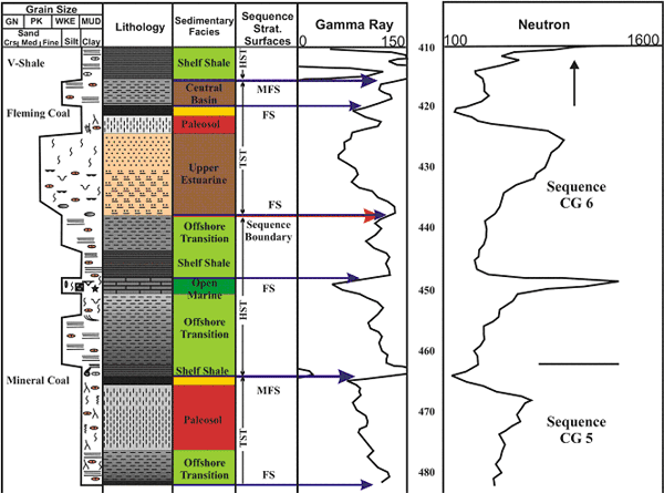
4.2.10 Sequence CG6
Sequence Cherokee Group 6 (CG6), is distributed over the entire study area and consists of the Bevier coal, Verdigris Limestone, V-shale, Croweburg coal, and Fleming coal (Figures 4.01, 4.02). A surface of subaerial exposure at the base of the Fleming coal or erosion at the base of an unnamed underlying sandstone observed in cores, is interpreted as the basal boundary for sequence CG6 (Figures 4.03 and 4.08). A basinward shift in facies is observed in cores as the transition from offshore deposits in the HST of CG5 to estuarine environments or a thick paleosol in CG6 (Figure 4.08). Additionally, incised valley geometries are identified in cross-section (Figure 4.01). Marginal marine deposits observed at the base of sequence CG6 suggests that a marine flooding surface is coincident with the basal boundary of the sequence.
The lateral extent and high gamma-ray value of the V-Shale indicates a maximum flooding surface (MFS), and transition into the highstand systems tract of sequence CG6. Environments ranging from shelf to estuarine characterize the transgressive systems tract. Coals beds within the lower transgressive systems tract such as the Fleming are thin and highly discontinuous. The laterally extensive Croweburg coal is present at the top of the TST, and near the maximum flooding surface (Figures 4.01, 4.04 and 4.08). Although the Croweburg coal is relatively thinner than most other coals, it is one of the most extensive Pennsylvanian coals as it is correlatable across the mid-continent (Wanless, 1969). The highstand systems tract consists of shelf to offshore transition deposits and the Bevier coal (Figure 4.09). With sufficient thickness, continuity, quality (high organic content, low ash, low sulfur, high Btu/lb), and relatively high gas content, the Bevier coal in sequence CG6 is a secondary target for coalbed gas development in northern portion of the Cherokee basin.
Sequence Cherokee Group 5 and 6 |
 |
| Figure 4.09 - Sequence stratigraphic log characteristics of Cherokee Group 5 and 6, based on core and well log from the Cooper CW#1 well, 11-T35S-R18E, Labette County, Kansas (scale in feet). See Figure 2.15a for legend. |
4.2.11 Sequence CG7
Sequence Cherokee Group 7 (CG7), is distributed over the entire study area and contains the Fort Scott Limestone, Mulky coal, Iron Post coal, and Squirrel sandstone (Figures 4.01, 4.02). A surface of erosion at the base of the Squirrel sandstone observed in cores is interpreted as the basal boundary for sequence CG7 (Figure 4.10). A transition from shelf deposits in the HST of CG6 to estuarine and tidal environments or a thick paleosol in sequence CG7 observed in cores provide evidence for a basinward shift in facies (Figures 4.03 and 4.10). The presence of marginal marine deposits at the base of sequence CG7 suggests that a marine flooding surface is coincident with the basal boundary of sequence.
The regionally extensive, high gamma-ray, phosphatic black shale named the Excello Shale marks the maximum flooding surface and transition into the highstand systems tract (Figure 4.10). Moving up through the transgressive systems tract, environments range from shelf to restricted marine (Figure 4.10). Coal beds contained within the transgressive systems tract, such as the Iron Post and Mulky, are relatively thin and discontinuous (Figures 4.01 and 4.02). The highstand systems tract consists of two shoaling-upward cycles from shelf to open marine and restricted marine carbonates separated by a phosphatic black shale (Little Osage Shale) that is interpreted as a flooding surface (FS). With the combination of a highly gas-saturated thin coal (Mulky), and a moderately gas-saturated black shale (Excello), this sequence is a major economic coal and shale gas target.
Sequence Cherokee Group 7 |
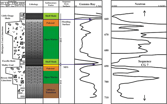 |
| Figure 4.10 - Sequence stratigraphic log characteristics of Cherokee Group 7, based on core and well log from the Hinthorn CW#1 well, 14-T32S-R16E, Montgomery County, Kansas (scale in feet). See Figure 2.15a for legend. |
e-mail : webadmin@kgs.ku.edu
Last updated December 2003
http://www.kgs.ku.edu/PRS/publication/2003/ofr2003-82/chapter4_1.html