Introduction
The Kansas Class 2 project is an effort to introduce Kansas
producers to useful technologies and to demonstrate these technologies
in actual oil field operations. In addition, all technologies
used as part of the project were adapted to be cost-effective
for independent operators of mature fields. The majority of Kansas
production is operated by small independent producers that do
not have resources to develop and test advanced technologies (90%
of the 3,000 Kansas producers have less than 20 employees). For
Kansas producer's, access to new technology is important for sustaining
production and increasing viability. A major emphasis of the project
is collaboration of university scientists and engineers with the
independent producers and service companies operating in Kansas
to accelerate adaptation and evaluation of new technologies. An
extensive technology transfer effort is ongoing. Traditional technology
transfer methods (e.g., publications and workshops) are supplemented
with a public domain relational database and an online package
of project results that is available through the Internet. The
goal is to provide the independent complete access to project
data, project results and project technology on their desktop.
Project design, methodologies, data, and results are disseminated
through focused technology transfer activities. Technology transfer
activities include: development of cost-effective technologies
and software (e.g. PfEFFER, "Pseudoseismic, Modification
of BOAST 3); open-file reports; publication in trade professional,
and technical publications; workshops and seminars; and the establishment
of public access through the Internet. The target audience includes
other operators in the demonstration area, operators of other
Mississippian sub-unconformity dolomite reservoirs in Kansas,
operators of analogous shallow shelf carbonate reservoirs in the
Mid-continent, and technical personnel involved in reservoir development
and management.
Objectives and Significance
The majority of Mississippian production in Kansas occurs at
or near the top of the Mississippian section just below the regional
sub-Pennsylvanian unconformity. These reservoirs are a major source
of Kansas oil production and account for approximately 43% (21
million barrels in 1994) of total annual production (Carr et al.,
1995a, Figure 1.1). 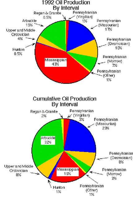 Cumulative
production from Mississippian reservoirs in Kansas exceeds 1 billion
barrels. Today, independent producers, operating many of these
reservoirs and production units, deal with high water cuts and
low recovery factors that place continued operations at or near
economic limits.
Cumulative
production from Mississippian reservoirs in Kansas exceeds 1 billion
barrels. Today, independent producers, operating many of these
reservoirs and production units, deal with high water cuts and
low recovery factors that place continued operations at or near
economic limits.
This project addressed producibility problems in the numerous
Kansas fields such as the Schaben field in Ness County that produce
from Meramecian and Osagian dolomites beneath the sub-Pennsylvanian
unconformity. Producibility problems in these reservoirs include
inadequate reservoir characterization, drilling and completion
design problems, and non-optimal primary recovery. Tools and techniques
developed as part of the project facilitate integrated, multi-disciplinary
reservoir characterization. All technologies used have been adapted
to be cost-effective for independent operators of mature fields.
Technologies include petrophysical analysis (PfEFFER), visualization
(Pseudoseismic), core analysis using NMR, numerical simulation
on a PC, and Internet technology transfer. The value of these
technologies for independent operators has been demonstrated.
All major operators at Schaben have adopted the results of the
reservoir management strategy developed as part of the study,
and have located and drilled approximately 20 infill locations.
Overall results of the incremental wells are very favorable. At
the Schaben Demonstration Site, the additional locations resulted
in incremental production increases of 200 BOPD from a smaller
number of wells.
Equally important is innovative dissemination of the data,
methodologies, and results to foster wider application of demonstrated
technologies by the numerous operators of similar fields throughout
the northern Mid-continent and US.
Site Description
The Schaben demonstration site consists of 1,720 contiguous
acres within Schaben field, located in Township 19 South--Range
21 West, Township 20 South--Range 21 West, and Township 19 South--Range
22 West, Ness County, Kansas (Figure 1.2). The leases comprising
the demonstration sites are highlighted in Figure 1.2. This site
is located in the upper shelf of the Hugoton Embayment of the
Anadarko Basin and produces oil from dolostones and limestones
of the lower Meramecian Warsaw Limestone and Osagian Keokuk Limestone
(Mississippian) at depths of 4,350-4,410 feet. The site is located
on the western flank of the Central Kansas uplift at the western
edge of the Mississippian Osagian subcrop beneath the sub-Pennsylvanian
unconformity (figures 1.3, 1.4,
1.5), and is typical of numerous other
Mississippian fields in Kansas.
Schaben field, discovered in 1963, consists of 78 completed
oil wells spaced primarily on 40-acre locations (Figure
1.3)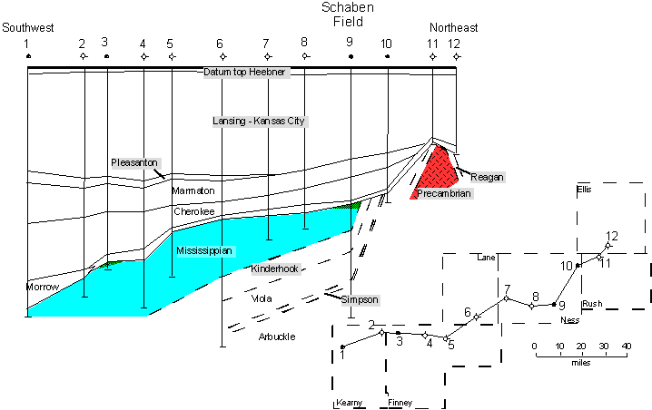 . Cumulative field production as
of October 1998 was 9.3 million barrels of oil (BO), and daily
field production was 502 BOPD from 47 wells (Figure 1.2). Compared
to production prior to infill drilling average daily production
has increased approximately 200 BOPD from a smaller number of
producing wells (during 1995 average production was 311 BOPD from
59 wells). From late 1996 through 1998, a total of twenty-two
infill locations were drilled or recompleted at the Schaben Demonstration
Site (Table 1.1). The locations were selected
based on the results of the reservoir management strategy developed
in Budget Period 1. All three major field operators (Ritchie Exploration,
Pickrell Drilling and American Warrior) used the Schaben reservoir
simulation to evaluate multiple locations and select optimum locations.
The In addition to production from the Mississippian,
one well produces oil from the Cherokee Group and the Fort Scott
Limestone, however, the relative volume of oil produced from these
secondary zones is small.
. Cumulative field production as
of October 1998 was 9.3 million barrels of oil (BO), and daily
field production was 502 BOPD from 47 wells (Figure 1.2). Compared
to production prior to infill drilling average daily production
has increased approximately 200 BOPD from a smaller number of
producing wells (during 1995 average production was 311 BOPD from
59 wells). From late 1996 through 1998, a total of twenty-two
infill locations were drilled or recompleted at the Schaben Demonstration
Site (Table 1.1). The locations were selected
based on the results of the reservoir management strategy developed
in Budget Period 1. All three major field operators (Ritchie Exploration,
Pickrell Drilling and American Warrior) used the Schaben reservoir
simulation to evaluate multiple locations and select optimum locations.
The In addition to production from the Mississippian,
one well produces oil from the Cherokee Group and the Fort Scott
Limestone, however, the relative volume of oil produced from these
secondary zones is small.
Participating Organizations
University of Kansas Center for Research Inc., the University
of Kansas Energy Research Center, the Kansas Geological Survey,
and the Tertiary Oil Recovery Project of Lawrence Kansas, and
Ritchie Exploration Inc. of Wichita, Kansas are participating
in the project. Total cost sharing in the project is 50 percent.
|
TABLE 1.1. List
of infill locations drilled or recompleted in the Schaben demonstration
area from late 1996 through 1998. The majority of locations were
selected based on the reservoir description and simulation results
resulting from the project. |
Well
Name/Year |
Operator |
API Number |
Status
Rates Per Day |
Location |
|
4 BP Twin / 1996 |
Ritchie Exploration |
15-135-23864 |
15 BO, 283 BW |
30-19S-21W, NW-NW-NE |
|
2 P Lyle Schaben / 1996 |
Ritchie Exploration |
15-135-23925 |
53 BO, 97 BW |
31-19S-21W, NE-NE-NE |
|
1 Gneich P Twin / 1996 |
Ritchie Exploration |
15-135-23933 |
13 BO 72 BW |
19-19S-21W, SW-SW-SE |
|
2-30 Moore / 1997 |
American Warrior |
15-135-23800 |
37 BO 0 BW |
30-19S-21W, SE-NE-SE |
|
6 DP Moore / 1997 |
Ritchie Exploration |
15-135-24006 |
60 BOPD, 100 BW, 241’ FOP |
30-19S-21W, NE-NW-NW |
|
3 AP Humburg / 1997 |
Ritchie Exploration |
15-135-24013 |
70 BOPD, 130 BW, 33’ FOP |
25-19S-22W, NW-SE-SE |
|
4 Humburg / 1997 |
Pickrell Drilling |
15-135-24010 |
70 BOPD, 130 BW, 1347’ FOP |
25-19S-22W, NE-NW-SE |
|
3 Borger / 1997 |
Pickrell Drilling |
15-135-23998 |
66 BOPD, 66 BW, 1426’ FOP |
25-19S-22W, SW-NE-NE |
|
4 Wittman/ 1997 |
American Warrior |
15-135-23958 |
108 BO. ? BW |
19-19S-21W, SE-SW-SW |
|
5 Wittman / 1997 |
American Warrior |
15-135-23966 |
108 BO. ? BW |
19-19S-21W, SW-SW-SW |
|
7 Rein AP / 1997 |
Ritchie Exploration |
15-135-24031 |
70 BOPD, 80 BW, 530’ FOP |
29-19S-21W, SW-NW-SW |
|
5 DP Moore / 1997 |
Ritchie Exploration |
15-135-23973 |
? |
30-19S-21W, NE-NE-NW |
|
4 CP Moore / 1997 |
Ritchie Exploration |
15-135-24030 |
? |
30-19S-21W, NW-NE-SW |
|
4 Borger / 1997 |
American Warrior |
15-135-24007 |
20 BO, 30 BW |
25-19S-22W, SE-NW-NE |
|
3-30 Moore / 1997 |
American Warrior |
15-135-23801 |
25 BO, Little Water |
30-19S-21W, NW-SE-NE |
|
1-30 Moore / 1997 |
American Warrior |
15-135-23799 |
13 BO, 21 BW |
30-19S-21W, NW-SW-SW |
|
3 Borger / 1997 |
American Warrior |
15-135-23969 |
250' FOP |
25-19S-22W, SE-SW-NE |
|
2X Humburg |
Mid Cont R |
15-135-24015 |
12 BO, 60 BW |
25-19S-22W, NW-NE-SE |
|
4 Borger |
Pickrell Drilling |
15-135-24048 |
40 BO, 9 BW |
25-19S-22W, NE-SE-NE |
|
1-26 Gillig |
American Warrior |
15-135-24052 |
15 BO, 110 BW |
26-19S-22W, NE-NE-SE |
|
6 Williams |
American Warrior |
15-135-24053 |
15 BO, 150 BW |
36-19S-22W, NE-NE-NW |
|
6 Wittman |
American Warrior |
15-135-23958 |
20 BO, 30 BW |
19-19S-22W, SE-SW-SW |
This page maintained by the
Kansas Geological Survey.
Updated June 1999
Comments to webadmin@kgs.ku.edu
URL=http://www.kgs.ku.edu/PRS/publication/99_22/intro.html