
Kansas Geological Survey
Open-file Report 2001-55
|
|
|
Kansas Geological Survey Open-file Report 2001-55 |
Differential dissolution of Arbuckle carbonates in the study area produced a characteristic karst surface with positive landforms and closed depression features at many different scales. Individual dolines in the study area can be as deep as 250 feet (75 meters) and encompass an area as wide as a mile (1.6kilometers). More typically, dolines are 30 to 60 feet deep (10 to20 meters) and have a diameter ranging from 1000 to 2000 feet (300 to 600 meters). It is likely that this surface is pitted with a large number of smaller dolines that were either too small in areato delineate from well spacing or did not exceed a depth of 10 feet (smallest contour interval used).
These dolines completely pit the landscape and when delimited on the basis of their topographic divides, form a cellular network termed polygonal karst by Williams (1972). When viewed three-dimensionally the residual hills of the Arbuckle surface form a polygonal network resembling a cock-pitted terrain.
Dolines on the Arbuckle surface appear to have a relatively consistent spatial pattern over most of the study area, most likely in response to a high degree of structural control. Structural control is defined as the degree of alignment bet-ween regional joints and depression major-axis orientations. This was tested by evaluating the coincidence of joint trends from major lineaments from gravity and magnetics to the orientations of karst depressions.
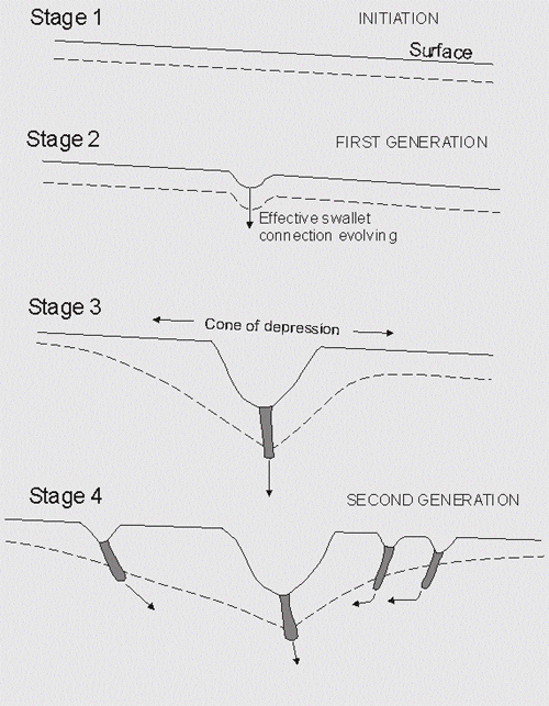 |
| Generalized model of depression genesis showing how primary depressions initiate formation of secondary depressions (Kemmerly, 1982). As the primary depression is enlarged and the hydraulic gradient is increased, more runoff is diverted into the subsurface along solution-widened joints around the perimeter. The increased ground-water recharge triggers the initiation of secondary dolines by removing the sediment filling solution-enlarged joints in the vicinity of the primary doline. |
|
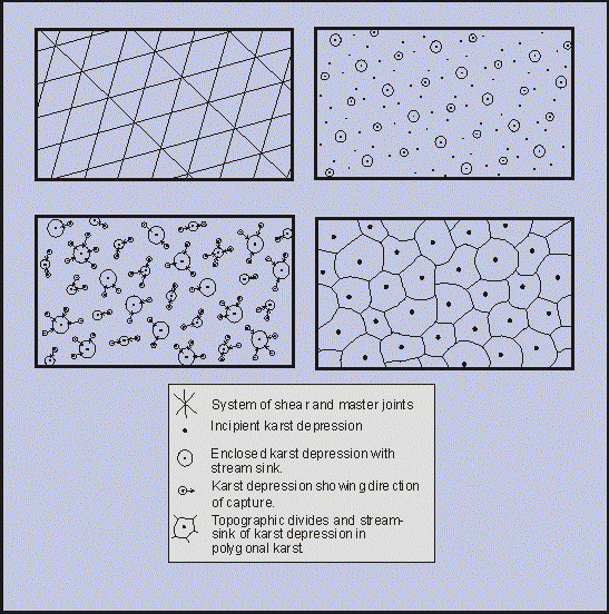
| William's (1972) model of polygonal karst that visualizes scattered small depressions on an uplifted surface. These depressions expand and capture smaller neighbors until the entire surface is pitted with depressions, the mutual divides of which form the cellular network of polygonal karst. |
|
|
|
e-mail : webadmin@kgs.ku.edu
Last updated January 2002
http://www.kgs.ku.edu/PRS/publication/OFR2001-55/P2-02.html