 Cherokee Coal Isopachs
Click on each of the Isopachs to show more detail
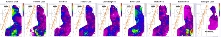
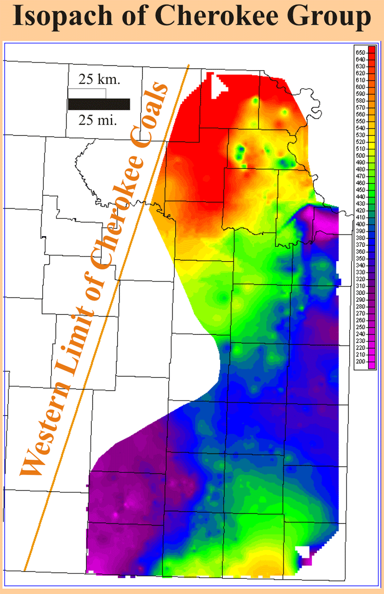
Isopach maps in ascending stratigraphic position (left to right) of selected coals in the Cherokee and Marmaton groups (Desmoinesian) across eastern Kansas. In eastern Kansas, the Cherokee Group is unconformable on the Mississippian limestone (Meramecian Stage). The top of the Mississippian is characterized by extensive karst and chert residuum. The Cherokee Group was deposited while the area was part of a slowly subsiding, intracratonic basin. Off of the Bourbon Arch, the Cherokee Group thickens to the south into Cherokee basin and the deeper Arkoma foreland basin. The Cherokee Group also thickens to the north into the Forest City basin. (See Cherokee isopach below).
Depositional environments range from relatively deep, low energy marine environments to shallow, marginal marine and nonmarine environments. In addition to the chemical and lithologic nature of an individual coal, depositional environments are reflected by their geometry, average thickness, areal extent and orientation.
Isopach mapping of the Riverton coal shows fairly consistent thickness over an average distance of 5 square miles (13 sq. km). This coal locally thickens into the Mississippian lows and thins onto the highs. The Riverton coal is consistently thicker in the deeper areas of the Cherokee and Forest City basins, while it thins to the east and onto the Bourbon arch.
Thickness of the Weir-Pittsburg coal can be up to 6 feet (2 m), but it averages 1.5 feet (0.5 m), and its thickness distribution's skewed to the minimum. The Weir-Pittsburg coal is recognizable on logs as the thickest coal in the Cherokee Group in the central part of the Cherokee basin. Of the many coals mined in the outcrop belt in southeastern Kansas, the Weir-Pittsburg coal is known to be the thickest and best-developed coal. Isopach mapping of the Weir-Pittsburg coal reveals a coal that is consistent in thickness over an average of 2.5 square miles (6.5 sq. km). In southeastern Kansas overlaying contours of top Mississippian structure on the isopach map shows the coal follows structural strike. The Weir-Pittsburg coal exhibits a lenticular geometry that is oriented parallel to NW-SE depositional strike. It is consistently thicker through an acute trend from southern Labette through Montgomery and Wilson counties. Localized circular thins of the Weir-Pittsburg coal may be due to removal by fire or crevasse splays.
http://www.kgs.ku.edu/PRS/publication/2004/AAPG/Coalbed/P2-02.html