Geostatistical 3D Reservoir Modeling of Mississippian St. Louis Carbonate Reservoir Systems, Kansas
Lianshuang Qi, Kansas Geological Survey, The University of Kansas
Abstract
Numerous St. Louis Limestone oolite reservoirs have continued to be discovered and developed across the Hugoton Embayment of southwestern Kansas. In Kansas, upper St. Louis reservoirs contain over 300 million barrels of oil, but the heterogeneous nature of the oolite shoals with other factors contributed relatively low recovery efficiencies. A 3D reservoir model can provide better understanding of external geometry, heterogeneity and spatial continuity within St. Louis oolite reservoirs. The improved 3D images can provide insight into the controls on geometry, distribution, and continuity of flow units in Mississippian oolite shoals.
Stratigraphic surfaces have been interpreted from the cores and well logs, and lithofacies described from cores were calibrated to log-defined petrofacies using log curves and a non-parametric discriminate analysis approach in selected St. Louis oolite reservoirs in Southwestern Kansas. With over 100 wells available, an integrated geologic and geostatistical approach was introduced to model the 3D architectural framework, external and internal geometry, rock property distributions within the reservoirs. An object-based stochastic approach was used to build 3D stratigraphic and lithofacies frameworks, and model the external geometries of St. Louis oolite shoals. Internal geometries were incorporated by building 3D porosity, permeability and water saturation distribution models using various stochastic simulation methods. Geostatistical models wil be verified, selected and extracted to upscale for later flow simulation study.
Quantitative 3D geostatistical models for St. Louis oolite reservoirs can provide a basis to improve reserve evaluation, enhance production management, and better understand the depositional controls on Mississippian oolite shoals.
Southwest Kansas Stratigraphy
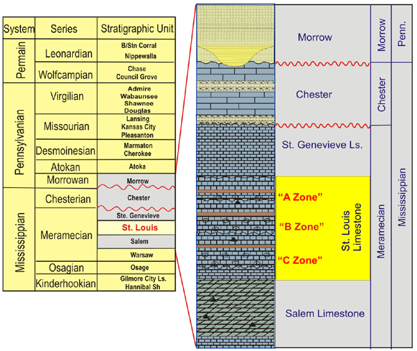
The St. Louis Limestone comprises approximately 200 feet of the Mississippian section in the Hugoton Embayment and consists of skeletal and oolitic limestone, peloidal limestone, dolomite and anhydrite. Oil is produced from three producing zones (A, B, C zone) formed of skeletal oolitic limestone.
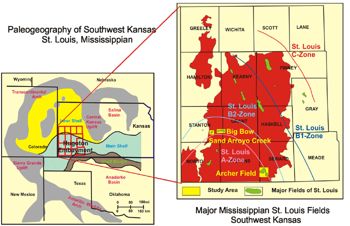
The Study Area is located in the Hugoton Embayment, which is flanked to the west and southwest by the Las Animas Arch and Sierra Grande uplift, and to the northeast by the Central Kansas uplift. The Mississippian sections dips gently from the north and thicken southward, reaching a thickness of more than 1,700 feet and merging with the deeper Anadarko Basin.
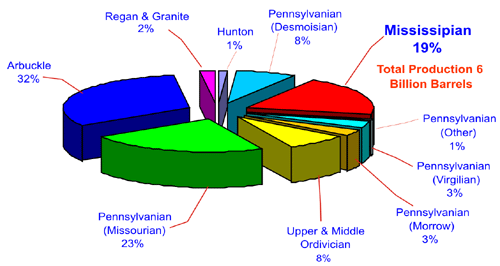 |
The total oil production from the Mississippian in
Kansas is over 6 billion barrels, mainly from skeletal oolitic limestone
reservoirs. |
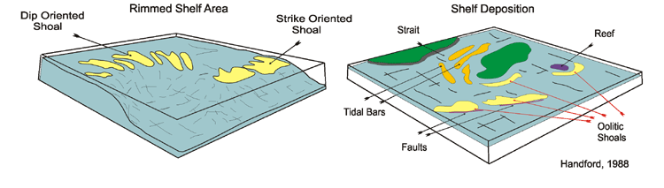
Oolite shoals are tabular shaped elongated bodies with thickness from 1 to 10’s of meters, width from hundreds of meters to several kilometers and length from several to tens of kilometers. Oolite shoals can amalgamate to form an oolite shoal complex.
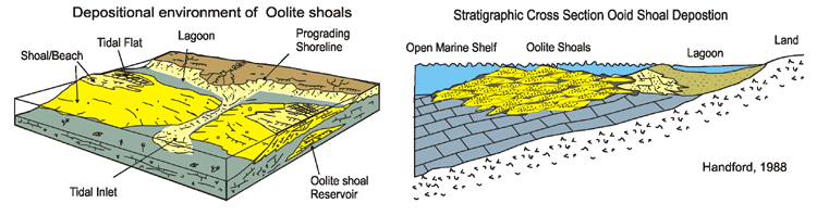
Many St. Louis oolite shoals have been deposited as linear-ramp, barrier-type shoals trending southwest of, and parallel to, a northwest-southeast shoreline flanking the Central Kansas Uplift. Other St. Louis oolite shoals have been interpreted as platform shoals that have localized deposition on sea-floor highs and near islands.
http://www.kgs.ku.edu/PRS/publication/2004/AAPG/3DReservoir/p1-01.html
Last Modified December 2004