 |

|
Kansas Geological Survey Open-file Report 2003-33 |
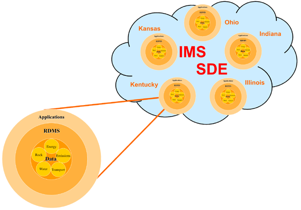
A major challenge of the MIDCARB project is to bring together into an efficient knowledge management system the millions of records pertaining to CO2 sequestration that resides in each state of the MIDCARB Consortium. The knowledge system provides global access across the organizations to manipulate pertinent geologic and engineering data. Relational databases are developed in each state to characterize stationary sources of CO2 and potential oil, gas, coal, and brine reservoirs for sequestration. The MIDCARB Consortium uses a distributed approach with applications, such as Internet Map Server (IMS) and Plot Servlets, that access and aggregate data from Relational Database Management Systems (RDBMS) at each organization. The system provides pre-selected map themes, custom map themes, and flexible query capabilities. The IMS is a scalable and failure-resistant system that can issue spatial queries to a spatial database engine (SDE) sitting on top of the RDBMS on each of the cooperating computers maintained by each MIDCARB organization. The system is built to be highly reliable and efficient with programming focused on interface technologies that will be of particular benefit to end-users in particular discipline areas, policy makers, and the interested public. Work is focusing on designing adequate metadata standards to assure data quality and consistency. Online users will see a single window to enter queries and receive results. However, the technical and spatial information on, both CO2 sources and potential CO2 sequestration sites, reside and are maintained at the local level (i.e., the individual states).
|
|
|
Last updated June 2003
http://www.kgs.ku.edu/PRS/publication//2003/2003-33/P2-02.html