 |
|
Kansas Geological Survey Open-file Report 2003-29 |
Introduction
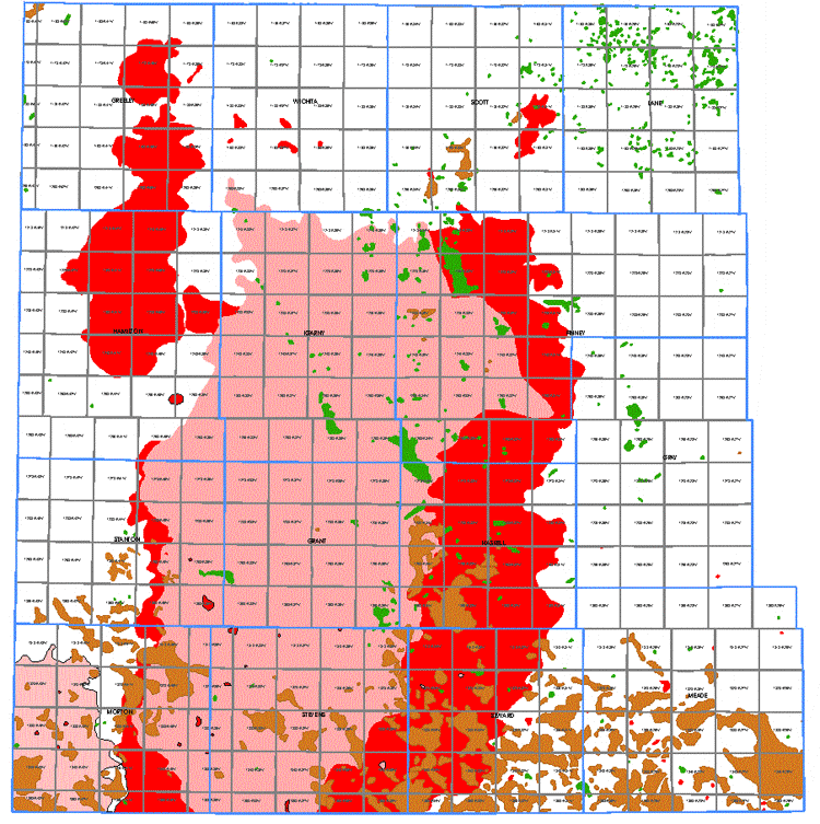
The Hugoton Embayment of southwest Kansas is a premier resource of natural gas in the United States and the world. The Hugoton Field, which is only one of the numerous gas and oil fields in the Hugoton area, is one of the largest gas field in North America and the world. Since 1928, the Permian gas fields of southwestern Kansas, including Hugoton, Panoma, Bradshaw and Byerly, have produced over 29 trillion cubic feet of gas. Hugoton production is a major source of gas and oil for the state and the nation. The major gas fields of this area have produced enough gas to supply every household in Kansas for 364 years, based on present gas consumption rates. In 2001 gas production from the area was 299 billion cubic feet and represents 72% of total Kansas gas production. Oil production in 2001 was 8.3 million barrels. This is over 25% of the state's annual oil production.
The value of the gas and oil produced in the 14 counties of southwest Kansas that comprise the Hugoton area exceeds 50% of the total value of gas and oil produced in the state. Gas and oil production from the Hugoton area of southwest Kansas is important if not critical to the economic health of the region and the state. Any enhancement to production in the Hugoton area helps to maintain the infrastructure necessary for the state's petroleum industry.
Even with this long history of substantial production, there is no publicly available field-wide study of how best to explore, produce, and regulate gas and oil in the Hugoton. Little is published at the field-scale of the fundamental geologic character of producing rocks, or the way that oil and gas moves or is trapped in those rocks. The Kansas Geological Survey (KGS) along with the KU Energy Research Center and a consortium of local producers, royalty owners, and other interested groups and individuals to have undertaken a comprehensive study of the oil and gas resources of the Hugoton area.
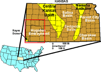
The Hugoton and associated gas fields are part of a northern shelf--like extension of a larger and deeper subsurface feature in Oklahoma and Texas known as the Anadarko basin. The Hugoton embayment is a large (about 12,000 square miles; 31,080 square kilometers), southward--plunging synform bounded by uplifted areas on the west, north, and east.
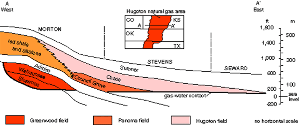
The Hugoton natural gas area was repeatedly inundated and exposed, leaving interbedded deposits of carbonate (limestone and dolomite) and shale. Sedimentary rocks thicken toward the middle of the basin and southward to about 9,000 feet (2,740 meters) near the Kansas--Oklahoma border. Oil and gas wells drilled in the deepest part of the Hugoton in Kansas are over 5,000 feet (1,520 meters) deep.
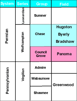
Natural gas and oil are produced from several different flow units and many individual fields. Most of the gas is produced from the Permian, Chase and Council Grove groups. The Hugoton, Byerly, and Bradshaw fields produce gas from the Chase Group. Council Grove Group production is restricted to the Panoma field that is underneath and geographically overlapped by the Hugoton field. Rocks that are deeper and older than these units also produce significant amounts of oil and gas in the Hugoton area, but many of these deeper zones have not been thoroughly tested. The potential for finding significant quantities of oil and gas is good, especially in the older Pennsylvanian and Mississippian rocks.
Gas accumulated in porous Permian limestone and dolomite and reservoir rocks. The rocks of the Chase and Council Grove groups are tilted slightly downward toward the east (and southeast) because of the Laramide uplift of the Rocky Mountains to the west.. The updip trap on the west and north sides of the field is a stratigraphic--type trap--that is, a trap created by a change from porous limestones and dolomites into nonmarine red shales and siltstones. The top seal is provided by the overlying Sumner Group, a very tight barrier of anhydrite and shale.
|
|
 |
|
|
|
e-mail : webadmin@kgs.ku.edu
Last updated May 2003
http://www.kgs.ku.edu/PRS/publication/2003/ofr2003-29/P1-04.html