Relationship Between Lineaments and Fluid Production
The relationship between the interpreted volumetric curvature lineaments and fluid flow in Dickman Field was investigated by examining the variability in fluid production from the producing wells in relation to lineament proximity.
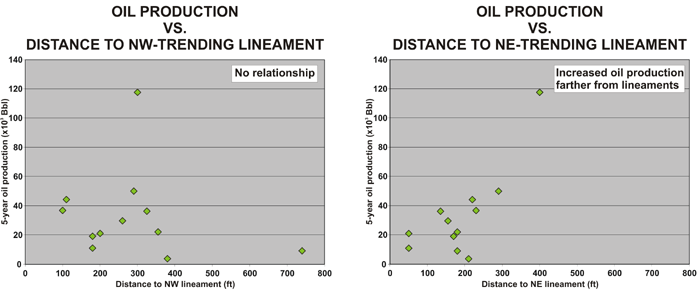
In order to evaluate whether there is a link between oil production and lineament orientation, oil production was crossplotted against the distance to the nearest NE- and NW-trending lineaments. The crossplots indicate that there is no identifiable relationship between oil production and the NW-trending lineaments, but there does appear to be an overall increase in oil production away from the NE-trending lineaments. This suggests that the NE-trending lineaments are barriers to fluid flow. Oil production adjacent to the lineaments may be inhibited because (1) wells close to a compartment boundary will have smaller drainage areas than wells in the middle of a compartment, and (2) reservoir quality may be degraded due to a higher concentration of shale-filled fractures in proximity to the lineaments.
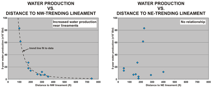
Water production from the wells in Dickman Field may be related to open fractures that extend into the underlying Mississippian aquifer. In order to evaluate whether open fractures are preferentially linked to lineament orientation, water production was crossplotted against the distance to the nearest NE- and NW-trending lineaments. The crossplots indicate that there is no relationship between water production and the NE-trending lineaments, but there is increased water production with closer proximity the NW-trending lineaments. A power law function provides a good fit to this relationship. These results suggest that the NW-trending lineaments represent fractures that serve as conduits to the aquifer.
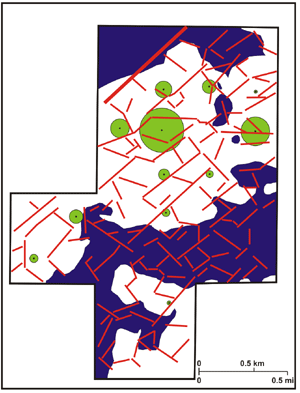
Bubble map showing with green circles the amount of oil produced during the first 5 years of production for each well within the Dickman seismic survey. The largest circle corresponds to approximately 117,600 Bbl. Interpreted lineaments are shown in red and areas where the top of Mississippian is below the oil-water contact are shown in dark blue.
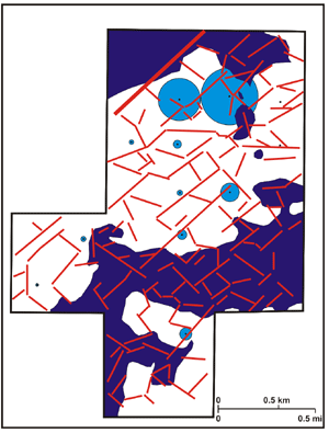
Bubble map showing with blue circles the amount of water produced during the first 5 years of production for each well within the Dickman seismic survey. The largest circle corresponds to approximately 830,500 Bbl. Interpreted lineaments are shown in red and areas where the top of Mississippian is below the oil-water contact are shown in dark blue.
http://www.kgs.ku.edu/PRS/AAPG2005/karst/p3-01.html
Last Modified December 2005