2002 Annual Water Level Raw Data Report for Kansas
Prev Page--Executive Summary || Next Page--Conclusions
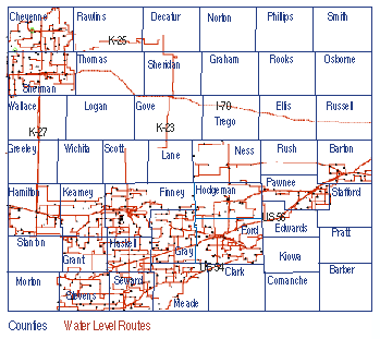
A field crew from the KGS acquired data from 495 wells in 15 western Kansas counties during January 2002 (Figure 2). The measurement technique and overall responsibilities associated with the 2002 annual water level measurement program were completely consistent with previous years' acquisition activities of both the USGS and KGS (Miller, 1996; Miller, Davis, and Olea, 1997; Olea, 1997; Miller, Davis, and Olea, 1998; Miller and Davis, 1999; Miller, Davis, and Laflen, 2000; Laflen and Miller, 2001). Prior to 2001, data acquisition was accomplished during two field periods with the first (primary) extending approximately from January 3 to January 9, with the second about a week later. During primary acquisition, each well was visited and data collected (water level below ground surface, well condition, GPS, photograph, well characteristics, and general observational notes). New in 2001, enhancement/replacement wells were located and measured during the primary visit as well as all the Quality Assurance (QA), Quality Control (QC), and missing (MIA) wells. The secondary acquisition, designed to finish the measurement of QA, QC, and other missing wells, was incorporated into the primary acquisition campaign for 2001, thus removing the need for a "clean up" or secondary trip. In 2002, difficult-to-measure or initially inaccessible wells have been visited multiple times by several individuals, usually within 24 hours of the initial suspect reading, thus giving a more timely comparison of individual results and a better understanding of potentially problematic areas. All raw data acquired by the KGS on the annual water level measurement program were compiled, digitally stored, and available for widespread circulation in their raw, unprocessed form (digital and/or analog) on or about March 1, 2002. This section represents a summary of all KGS activity related to the raw data, acquisition activities, and technique development.
Acquisition Logistics
The 2002 measurement trip was completed in 5 days by a crew of six people (with a seventh picking up problem wells and measuring new wells). Each person was equipped with a vehicle, computer, GPS, cellular phone, field notes, steel measuring tape, and associated supplies. The far northwestern counties (Cheyenne, Sherman, Thomas, and Wallace) were completed the first day, requiring an overnight stay in Syracuse. The second day of measurements ended in Garden City and saw the completion of two counties (Hamilton and Kearny). The third field day ended in Liberal with three counties finished (Finney, Haskell, and Grant). The fourth day ended in Dodge City, with three more counties (Stevens, Seward, and Meade) completed. The crew returned to Lawrence on the fifth day after completing four more counties (Gray, Ford, Hodgeman, and Ness).
During the primary acquisition trip the six crew members were divided into three teams. Each team was responsible for 28 to 42 wells per day along predesignated closed routes. Each day's route was designed so team members would meet along the route after all wells were visited. This method balanced workloads by compensating for different degrees of measurement difficulty (different lengths of time are necessary to measure individual wells), insured that no wells were overlooked during the primary measurement trip, and minimized the number of miles traveled per well and route. Distribution of crew members and routes was designed to insure that no crew member was more than 15 to 20 miles from another crew member. This increased safety and minimized the time necessary to complete a county. Once a team completed its route, the other teams were contacted to determine if assistance was necessary to complete all routes prior to sunset. After a team completed its route and fulfilled any requests for assistance, they proceeded to a pre-designated motel. Approximately 11,500 miles were logged during the measurement trip with the average crew member visiting 17 wells per day and spending about 15 minutes at each well and about 25 minutes traveling from well to well.
QC/MIA/QA Wells
Prior to 2001 the QC/MIA/QA/enhancement well trip required a minimum of two days for two people to complete. In 2001 the QC/MIA/QA/enhancement data acquisition was incorporated into the primary trip, thus eliminating the second trip and adding to the overall program efficiency. The QC accomplished during the primary trip was designed to remeasure wells classified as out of trend during primary acquisition. The 2002 QC water level re-measurement included wells in all counties. These wells were selected based on the following criteria:
The QA acquisition provided repeat measurement data for the purpose of statistical appraisal of measurement error. Fifty-one wells, or about 10% of all the wells measured by the KGS during 2002, were randomly selected by computer for re-measurement.
Again this year, an attempt was made to fill some of the spatially under-sampled areas within the network (Olea, 2001). To fully sample the High Plains Aquifer from water level data, 13 new well sites were needed. Input from the GMDs, DWR, and KGS identified 13 wells in areas that are spatially undersampled and that have sufficient historical and construction data to justify an attempted measurement. From those 13 candidate wells, 12 were sampled during 2002 as new annual network wells. The selection and measurement of these enhancement wells is critical to establishing a method for maintaining the health and continuity of the network through the insertion of new wells to replace unusable wells already in the network.
Well and Measurement Point Information
A few key well characteristics have been compiled for general information and incorporation into efforts to improve and maximize the network. Statistics and characteristics for DWR wells are also included.
| Wells Measured in 2002 | ||
|---|---|---|
| Type of Well | KGS | DWR |
| Irrigation | 397 | 599 |
| Unused (monitor or abandoned) | 87 | 179 |
| Stock | 17 | 31 |
| Household | 6 | 21 |
| Depth to Water | KGS | DWR |
| Less than 100 ft | 151 | 481 |
| 100 to 200 ft | 222 | 257 |
| 200 to 300 ft | 103 | 48 |
| More than 300 ft | 19 | 5 |
| Drill Depth of Well | KGS | DWR |
| Unknown | 64 | 89 |
| Less than 100 ft | 58 | 265 |
| 100 to 200 ft | 69 | 285 |
| 200 to 300 ft | 130 | 144 |
| 300 to 400 ft | 97 | 33 |
| More than 400 ft | 86 | 29 |
| Measurement Characteristics | KGS | DWR |
| Oil on the water | 94 (18.4%) | 125 (14.7%) |
| Difficult measurement (restrictions, snags, catches) |
32 (6.3%) | 52 (6.1%) |
| Noted changes in restrictions | 27 (5.4%) | 7 (0.9%) |
In-field confidence in a particular measurement was qualitatively determined through inspection of chalk cut while general accuracy was quantitatively appraised using historical and local trends.
| Measurement Confidence | ||
|---|---|---|
| Wells Measured Only | KGS | DWR |
| Once | 324 | 787 |
| Twice | 131 | 9 |
| Three times | 26 | 1 |
| Four times | 14 | 0 |
| Total Measurements | KGS | DWR |
| Primary, QA, and QC | 840 | 832 |
| Measurements Judged | KGS | DWR |
| Excellent | 462 | 660 |
| Good | 25 | 131 |
| Fair | 10 | 6 |
Network Continuity
An uninterrupted historical record is important for trend determination and analysis. Significant efforts were made to acquire measurements in all wells regardless of whether the well had been successfully measured in any of the last three years. Wells with problems that were not likely to improve between measurement years were identified by each measurer and then cross-checked by the QC measurer. If both visitors indicate that a well needs to be removed from the network, it generally is dropped from the next year's list of annual measurement wells. A total of 15 wells were flagged by KGS field personnel during the 2002 acquisition season.
| 15 Wells from KGS Portion Requiring Replacement and Reason--2002 | |
|---|---|
| 09S 42W 08 AAA 01 | Plugged. |
| 22S 24W 25 DDC 01 | Confined space with electrical hazard. |
| 22S 33W 22 BAA 01 | Dry. |
| 23S 31W 28 CDD 02 | Pumping. |
| 24S 36W 33 ADD 01 | Plugged. |
| 25S 33W 03 BCC 01 | Blockage. |
| 26S 29W 35 CCC 01 | Blockage. |
| 26S 41W 32 DDB 01 | Difficult measure. |
| 27S 27W 01 BAA 01 | Blockage. |
| 27S 37W 04 ABB 01 | Abandoned and plugged. |
| 27S 38W 15 BBB 01 | Downhole damage. |
| 28S 36W 31 BDD 01 | No information. |
| 30S 32W 31 BAB 01 | No information. |
| 31S 35W 15 BAA 01 | No M.P. |
| 34S 38W 34 CAA 01 | Could not enter M.P. |
| 16 Wells from DWR Portion Requiring Replacement and Reason--2002 | |
| 01S 23W 15 AAA 01 | Destroyed. |
| 03S 30W 03 CBA 01 | Destroyed. |
| 04S 29W 10 DCC 01 | No MP. |
| 04S 30W 07 BBB 01 | Collapsed. |
| 15S 41W 05 ACB 01 | Plugged. |
| 16S 41W 20 ABC 01 | Plugged. |
| 19S 38W 26 CCB 01 | Destroyed. |
| 19S 38W 26 CBB 01 | No M.P. |
| 20S 37W 29 DCC 01 | Plugged. |
| 22S 13W 12 CAC 01 | Destroyed. |
| 22S 17W 27 BAB 01 | Destroyed. |
| 23S 07W 20 BCA 01 | Destroyed. |
| 26S 09W 10 DDB 01 | Destroyed. |
| 27S 43W 02 BDD 01 | Destroyed. |
| 29S 35W 28 ACC 01 | Collapsed. |
| 30S 36W 04 ABB 01 | Cascading water, unable to see chalk cut. |
To maintain the long-term health and continuity of the network, both wells that should be replaced and acceptable replacements should be immediately identified. Field observations are the most important and insightful method of identifying wells needing replacement; however, statistical quality control analysis has provided valuable insight into the reliability of network wells measured in 2002.
For a fourth year the KGS crews were deployed with acquisition software running on notebook PCs interfaced to GPS units. This system has been under development at the KGS for the last five years. It is designed to provide the measurer with historical data, warning messages in the event of an out-of-trend measurement or incorrect well location, automated depth-to-water calculations based on hold and cut, and real-time tracking and vehicle location displays. The system's primary focus is on insuring that the correct wells are measured and on enforcing complete well site documentation. The GPS units provide the associated computer with a tracking log, which permits time and location of each measurer to be determined throughout the day. During the 2002 measurement program the KGS crews logged over 11,500 miles in 5 days (Figure 3). GPS-measured latitudes and longitudes can be extracted from this log and used to improve the accuracy of well locations in WIZARD.
Figure 3--Example of tracking logs of measurers during the first 6 days
of the measurement program as recorded by the GPS/computer systems located in
each vehicle.
The raw data tabulated in this report are organized into five appendices. A brief discussion of the contents of each appendix follows.
| Appendix A | Contains a summary of information for all wells measured by KGS. This appendix includes only county, well legal description (ID), and 2002 depth of water below ground surface (BGS). QA measurements (QA) are identified. |
| Appendix B | The same information as Appendix A, but for DWR wells. |
| Appendix C | Contains all measurements and characteristics taken at every well in the KGS portion of the network. Included are the following categories of informa-tion: County, legal description (ID), GPS Lat, GPS Long, hold point, cut line, measurement point (MP) elevation, 2002 depth to water BGS, initials of measurer, measuring agency, and all comments. |
| Appendix D | The same information as Appendix C, but for DWR wells. |
| Appendix E | List by county of wells (legal description, ID) measured as part of the QA program. The list includes the primary measurement of DTW and the QA measurement of DTW. |
| Appendix F | Contains the same information as Appendices C and D for all enhancement wells. |
A direct comparison of primary measurements and the QA measurements made by the KGS reveals important information about the accuracy and repeatability of information in the database (Appendix E). In general, the time separation between the primary and QA measurements is less than 24 hours in all cases, and often the same day. This re-measure information, along with parts of the primary data, are integral to quality control discussions documented in subsequent sections of this report.
KGS Data Acquisition Summary
In summary, this year's effort by the KGS staff to acquire annual water level measurements met or exceeded most expectations. Based on preliminary analysis:
1) Systematic errors are an important indicator of erratic wells that should be removed from the network to insure that the network is accurate and that confidence can be placed in the data (see Davis, 2002).
2) More data have been acquired in each of the last six years (1997-2002) than in the previous 7 years (1990-1996).
3) The availability of digital and analog measurement data (for entire network) to DWR, KGS Geohydrology staff, and GMDs has been dramatically improved over years prior to 1997. These data will be provided on CD-ROM.
4) Field acquisition time has been reduced (2002 and 2001 required 5 days; 2000 and 1999 required 5.5 days; 1998 required 6.5 days; 1997 required 8 days); the historical average of time required for field data collection has been about 2 months.
5) Long-term improvements to the network and database are being made.
6) The total program costs for 1999, 2000, 2001, and 2002 were about 75% of 1998 and 1997, which were both consistent with the amount paid to the USGS in 1996 to complete this study. When calculated using an equivalent* product, the cost to the Kansas Survey for the 1997 and 1998 water level data is about half that assessed by the USGS in 1996 and less than one-third of the USGS 1996 costs for the 1999 acquisition season. [*Equivalent product cost does not include extra program activities such as QA or QC data acquisition, analysis, or computer and GPS equipment.]
Development of a Kansas water well database was undertaken by the KGS in an attempt to make information quickly and easily accessible to the general public about water wells, both those that are part of the annual network and many that are not. This database will hopefully provide quick and accurate information about potential replacement or enhancement candidates throughout the State. At the present time this database is still under development, but should be fully operational by next field season. The database, by design, will include all significant information contained in the USGS's GWSI database, the KGS's KIWI database, and the KGS's WaterWitch database. It is the intent of the database's designers to incorporate portions of DWR's WRIS, KDHE's WWC5, City of Wichita, and each of the five GMDs' water well databases. Once this database, named WIZARD, is complete it should contain the most inclusive listing anywhere of information on water wells in Kansas. It is the intent that frequent uploads from each of the parent databases will insure that information in the database is current.
Prev Page--Executive Summary || Next Page--Conclusions