currently headed by John Morrison of the Independent Oil and Gas Service, Wichita.
| Oil and Gas Fields Added, March 2015 | ||
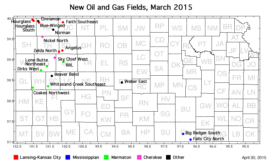
| Fields are named by the Kansas Geological Society's Nomenclature Committee, currently headed by John Morrison of the Independent Oil and Gas Service, Wichita. |
||
| Field | Well | Operator | API Number | Latitude | Longitude | Location | Pay Zone |
|---|---|---|---|---|---|---|---|
| Angelus | Baalman 1-6 | Samuel Gary Jr. and Assoc., Inc. | 15-179-21383 | 39.2137632 | -100.6063135 | sec. 6, T. 10 S., R. 29 W. | Lansing-Kansas City |
| Beaver Bend | DAMW 1-11 | Murfin Drilling Co., Inc. | 15-171-21073 | 38.5900902 | -100.9289918 | sec. 11, T. 17 S., R. 33 W. | Cherokee, Penn Basal Cong. |
| Big Badger South | McConaghy 17-1 | Taos Resources Operating Company LLC | 15-035-24605 | 37.1841408 | -96.907427 | sec. 17, T. 33 S., R. 5 E. | Mississippian |
| Blue-Winged | Wilkinson Trust 'KP' 1-2 | Murfin Drilling Co., Inc. | 15-153-20989 | 39.9092361 | -101.333073 | sec. 2, T. 2 S., R. 36 W. | Lansing-Kansas City |
| Cinnamon | Cheryl 1-33 | Murfin Drilling Co., Inc. | 15-153-21107 | 39.9185877 | -101.3601229 | sec. 33, T. 1 S., R. 36 W. | Pennsylvanian |
| Coakes Northwest | Berning 1-16 | Red Oak Energy, Inc. | 15-203-20288 | 38.3122756 | -101.5179679 | sec. 16, T. 20 S., R. 38 W. | Marmaton |
| Dirks West | Harold Michaelis Family Trust 1 | Palomino Petroleum, Inc. | 15-109-21383 | 38.7287729 | -101.2555016 | sec. 30, T. 15 S., R. 35 W. | Marmaton |
| Falls City North | Smith 1-32 | Lawco Holdings, LLC | 15-035-24630 | 37.0446548 | -96.6863158 | sec. 32, T. 34 S., R. 7 E. | Mississippian |
| Faith Southeast | Mary 1 | Pauley Oil | 15-039-21203 | 39.8963508 | -100.6047863 | sec. 8, T. 2 S., R. 29 W. | Lansing-Kansas City |
| Hourglass | Owens Trust 1-19 | BEREXCO LLC | 15-023-21416 | 39.9577495 | -101.5158958 | sec. 19, T. 1 S., R. 37 W. | Lansing-Kansas City |
| Hourglass South | Sowers 1-19 | Murfin Drilling Co., Inc. | 15-023-21414 | 39.9459496 | -101.5074722 | sec. 19, T. 1 S., R. 37 W. | Lansing-Kansas City |
| Lone Butte Northeast | Marius 1-15 | New Gulf Operating LLC | 15-109-21292 | 38.8340195 | -101.0842158 | sec. 15, T. 14 S., R. 34 W. | Marmaton |
| Nickel North | Studer 1-9 | Brito Oil Company, Inc. | 15-193-20946 | 39.5494725 | -101.2269902 | sec. 9, T. 6 S., R. 35 W. | Cherokee |
| Norman | Norman 1-11 | Blue Ridge Petroleum Corporation | 15-153-21077 | 39.7234265 | -100.8845739 | sec. 11, T. 4 S., R. 32 W. | Lansing-Kansas City, Shawnee |
| RRL | Lewis 1 | Charter Energy, Inc. | 15-063-22228 | 38.938094 | -100.5834632 | sec. 7, T. 13 S., R. 29 W. | Marmaton |
| Sky Chief West | Mathers 1-2 | Red Oak Energy, Inc. | 15-109-21385 | 39.0416124 | -100.8363186 | sec. 2, T. 12 S., R. 32 W. | Cherokee |
| Weber East | Roberts/Phillips Unit 1-6 | F. G. Holl Company L.L.C. | 15-009-26060 | 38.4298308 | -98.7939784 | sec. 6, T. 19 S., R. 13 W. | Arbuckle |
| Whitesand Creek Southeast | Koehn 3-10 | K3 Oil & Gas Operating Company | 15-171-21117 | 38.3411226 | -101.0581434 | sec. 3, T. 20 S., R. 34 W. | Marmaton |
| Zelda North | Bixenman Brothers 1-18 | Culbreath Oil & Gas Company, Inc. | 15-179-21391 | 39.1890281 | -100.712872 | sec. 18, T. 10 S., R. 30 W. | Lansing-Kansas City |
|
Kansas Geological Survey, Oil and Gas Information Updated April 30, 2015 Comments to webadmin@kgs.ku.edu The URL for this page is http://www.kgs.ku.edu/Magellan/Field/NMC/mar_2015.html |