currently headed by John Morrison of the Independent Oil and Gas Service, Wichita.
| Oil and Gas Fields Added, Dec. 2013 and Jan. 2014 | ||
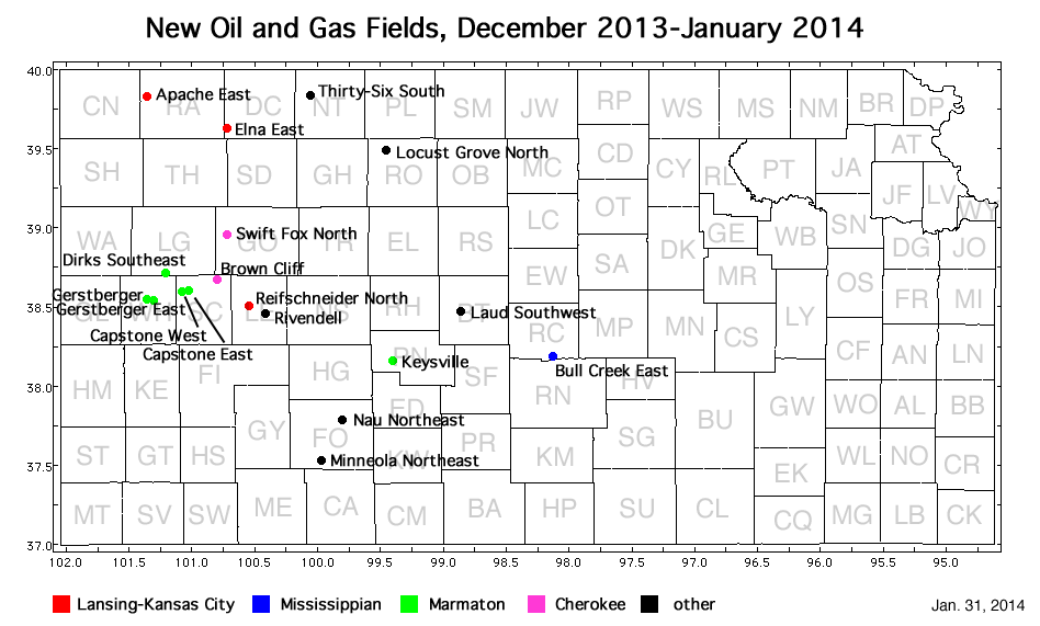
| Fields are named by the Kansas Geological Society's Nomenclature Committee, currently headed by John Morrison of the Independent Oil and Gas Service, Wichita. |
||
| Field | Well | Operator | API Number | Longitude | Latitude | Location | Pay Zone |
|---|---|---|---|---|---|---|---|
| Apache East | Solko 1-33 | Murfin Drilling Co., Inc. | 15-153-20930 | -101.3542711 | 39.8301777 | sec. 33, T. 2 S., R. 36 W. | Lansing-Kansas City |
| Brown Cliff | Brown Trust 1-12 | Mull Drilling Co., Inc. | 15-171-20932 | -100.7990455 | 38.6739135 | sec. 12, T. 16 S., R. 32 W. | Cherokee |
| Bull Creek East | Randolph Trust 2107 31-1H | Shell Gulf of Mexico Inc. | 15-159-22723-0100 | -98.1254575 | 38.1872346 | sec. 31, T. 21 S., R. 7 W. | Mississippian |
| Capstone West | Rose 1-3 | Landmark Resources, Inc. | 15-171-20984 | -101.0692949 | 38.6043678 | sec. 3, T. 17 S., R. 34 W. | Marmaton |
| Capstone East | Beeson Trust 1-1 | Landmark Resources, Inc. | 15-171-20985 | -101.0267359 | 38.6088688 | sec. 1, T. 17 S., R. 34 W. | Marmaton |
| Dirks Southeast | Ken Baker 'B' 34-1 | Russell Oil, Inc. | 15-109-21201 | -101.2035925 | 38.711234 | sec. 34, T. 15 S., R. 35 W. | Marmaton |
| Elna East | Juenemann 1-7 | Murfin Drilling Co., Inc. | 15-039-21186 | -100.7238656 | 39.637393 | sec. 7, T. 5 S., R. 30 W. | Lansing-Kansas City |
| Gerstberger | Gerstberger 1-30 | Landmark Resources, Inc. | 15-203-20231 | -101.343995 | 38.5508776 | sec. 30, T. 17 S., R. 36 W. | Marmaton |
| Gerstberger East | Gerstberger 1-29 | Murfin Drilling Co., Inc. | 15-203-20233 | -101.3145119 | 38.5493543 | sec. 29, T. 17 S., R. 36 W. | Marmaton |
| Keysville | J-P Unit 1 | Carmen Schmitt, Inc. | 15-145-21588 | -99.40324 | 38.16052 | sec. 10, T. 22 S., R. 19 W. | Marmaton |
| Laud Southwest | Loretta Polzin Trust 1-22 | L. D. Drilling, Inc. | 15-009-25894 | -98.8606254 | 38.4672728 | sec. 22, T. 18 S., R. 14 W. | Arbuckle |
| Locust Grove North | Griebel-Miller 1-33 | Brito Oil Company, Inc. | 15-163-24143 | -99.4479014 | 39.492945 | sec. 33, T. 6 S., R. 19 W. | Shawnee |
| Minneola Northeast | Shelor 1-17 | Vincent Oil Corp. | 15-057-20910 | -99.9643947 | 37.5286109 | sec. 17, T. 29 S., R. 24 W. | Cherokee, Mississippian |
| Nau Northwest | Galen Durler 1 | Ritchie Exploration, Inc. | 15-057-20906 | -99.8020121 | 37.7790898 | sec. 14, T. 26 S., R. 23 W. | Atoka |
| Reifschneider North | Patricia Wood 1-9 OWWO | Larson Operating Co. | 15-101-21945-0001 | -100.53625 | 38.4984514 | sec. 9, T. 18 S., R. 29 W. | Lansing-Kansas City |
| Rivendell | Eugene 1-27 | Larson Operating Company | 15-101-22455 | -100.407737 | 38.4533992 | sec. 27, T. 18 S., R. 28 W. | Lansing-Kansas City, Marmaton, and Cherokee |
| Swift Fox North | Fern Ottley 1 | Prospect Oil and Gas Corp | 15-063-22110 | -100.7258138 | 38.9580872 | sec. 2, T. 13 S., R. 31 W. | Cherokee |
| Thirty-Six South | Rule 1-31 | Blue Ridge Petroleum Corp. | 15-137-20674 | -100.062728 | 39.8338782 | sec. 31, T. 2 S., R. 24 W. | Granite Wash |
|
Kansas Geological Survey, Oil and Gas Information Updated Jan. 31, 2014 Comments to webadmin@kgs.ku.edu The URL for this page is http://www.kgs.ku.edu/Magellan/Field/NMC/jan_2014.html |