currently headed by John Morrison of the Independent Oil and Gas Service, Wichita.
| Oil and Gas Fields Added, Feb. 2015 | ||
| Fields are named by the Kansas Geological Society's Nomenclature Committee, currently headed by John Morrison of the Independent Oil and Gas Service, Wichita. |
||
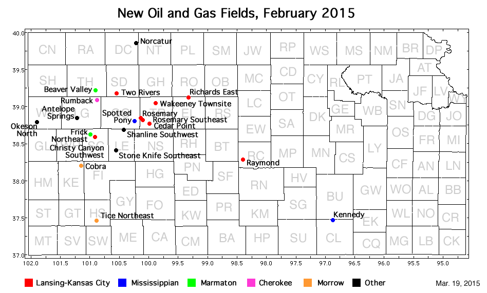
| Field | Well | Operator | API Number | Latitude | Longitude | Location | Pay Zone |
|---|---|---|---|---|---|---|---|
| Antelope Springs | Wood 'A' 1 | Black Tea Oil, LLC | 15-109-21384 | 38.8415416 | -101.2144402 | sec. 16, T. 14 S., R. 35 W. | Lansing-Kansas City, Cherokee |
| Beaver Valley | Beaver Valley Supply 4 1 | LB Exploration, Inc. | 15-193-20924 | 39.2133257 | -100.9003272 | sec. 4, T. 10 S., R. 32 W. | Marmaton |
| Cedar Point | CK Gaither OK 1-3 | Phillips Exploration Company L.C. | 15-195-22974 | 38.7781706 | -99.9818266 | sec. 3, T. 15 S., R. 24 W. | Lansing-Kansas City |
| Christy Canyon Southwest | Ellis 1-12 | Stelbar Oil Corporation, Inc. | 15-171-21103 | 38.597227 | -100.9082438 | sec. 12, T. 17 S., R. 33 W. | Lansing-Kansas City |
| Cobra | Cobra 26-1 | Merit Energy Company, LLC | 15-093-21927 | 38.1945651 | -101.1327136 | sec. 26, T. 21 S., R. 35 W. | Morrow |
| Frick Northeast | Stoll 1-32 | Grand Mesa Operating Company | 15-171-21097 | 38.61746 | -100.9815995 | sec. 32, T. 16 S., R. 33 W. | Marmaton |
| Kennedy | Kennedy 1-3 | Val Energy, Inc. | 15-035-23967-0001 | 37.4632345 | -96.8693199 | sec. 3, T. 30 S., R. 5 E. | Mississippian |
| Norcatur | Benton-Kiser 1-26 | Prairie Fire Petroleum, LLC | 15-039-21212 | 39.8544132 | -100.211519 | sec. 26, T. 2 S., R. 26 W. | Reagan Sandstone |
| Okeson North | Schemm 1 PEC | Phillips Exploration Company L.C. | 15-199-20409 | 38.7864548 | -101.8936702 | sec. 32, T. 14 S., R. 41 W. | |
| Raymond | Brian C-1 | Carrie Exploration & Development, LLC | 15-159-22799 | 38.2810874 | -98.4011621 | sec. 26, T. 20 S., R. 10 W. | Lansing-Kansas City |
| Richards East | Lohrey 'A' 1-4 | Trans Pacific Oil Corp. | 15-051-26737 | 39.1213339 | -99.3291774 | sec. 4, T. 11 S., R. 18 W. | Lansing-Kansas City |
| Rosemary | Rosemary 1-SHR | Phillips Exploration Company L.C. | 15-195-22965 | 38.8257047 | -100.1199605 | sec. 20, T. 14 S., R. 25 W. | Lansing-Kansas City |
| Rosemary Southeast | Nichol 1 | Palomino Petroleum, Inc. | 15-195-22966 | 38.817481 | -100.107381 | sec. 21, T. 14 S., R. 25 W. | Lansing-Kansas City |
| Rumback | Rumback 'B' 21-1 | Russell Oil, Inc. | 15-109-21373 | 39.0868857 | -100.8752443 | sec. 21, T. 11 S., R. 32 W. | Cherokee |
| Shanline Southwest | James' Children's Trust 1-9 | Larson Operating Company | 15-101-22541 | 38.6826957 | -100.4221938 | sec. 9, T. 16 S., R. 28 W. | Lansing-Kansas City, Marmaton, Cherokee |
| Spotted Pony | MMJ 1 | Palomino Petroleum, Inc. | 15-063-22235 | 38.8081361 | -100.2332836 | sec. 29, T. 14 S., R. 26 W. | Mississippian |
| Stone Knife Southeast | Kim 2 | Palomino Petroleum, Inc. | 15-101-22526 | 38.4052243 | -100.5550363 | sec. 17, T. 19 S., R. 29 W. | Marmaton, Cherokee |
| Tice Northeast | Jacob Moss 12-1 | Merit Energy Company, LLC | 15-081-22076 | 37.4595267 | -100.8876871 | sec. 12, T. 30 S., R. 33 W. | Morrow |
| Two Rivers | Bixenman 1 | Palomino Petroleum, Inc. | 15-179-21376 | 39.1783559 | -100.5338743 | sec. 14, T. 10 S., R. 29 W. | Lansing-Kansas City |
| Wakeeney Townsite | North Fork Farms 3-1 | H & C Oil Operating, Inc. | 15-195-22973 | 39.0418511 | -99.8696979 | sec. 3, T. 12 S., R. 23 W. | Lansing-Kansas City |
|
Kansas Geological Survey, Oil and Gas Information Updated March 19, 2015 Comments to webadmin@kgs.ku.edu The URL for this page is http://www.kgs.ku.edu/Magellan/Field/NMC/feb_2015.html |