|
|
|
|
KGS, Open-file Report 2000-13Next page--Appendix A |
March 2000
KGS Open-file Report 2000-13
The Kansas Geological Survey and the Division of Water Resources measured water table elevations at 1346 different sites in Kansas during January of 2000 as part of the annual water-level measurement program. 1240 wells (92.1%) monitor the water level in the High Plains aquifer.
Mapping the changes in water depth continues to show that the problem of aquifer depletion is more critical in southwest Kansas, while several other areas of the state show moderate reversal in the increase in water depth.
On average, depth to water increased at an annual rate of 0.28 ft during the last five years and at a rate of 0.36 ft during 1999.
Reliability of measurements and locations of wells have ceased to be a problem in the processing of the information. Moderate improvements were made in the reliability of the water-level sampling network by taking measurements at nine new wells with the intention of using them as observation wells.
The Kansas Geological Survey continues to monitor groundwater wells formerly measured by the U. S. Geological Survey. The Division of Water Resources (DWR) continues to measure the share of wells that it was monitoring prior to the time the Kansas Geological Survey assumed responsibility for the monitoring program.
The objective of this study is to display information on ground water levels collected in Year 2000 within the High Plains aquifer-the most important aquifer in the state of Kansas-to visualize trends in the depletion and recharge of the aquifer, to evaluate the impact that the addition of provisional observation wells has on the reliability of the network, and to suggest further changes to improve the capability of the network to properly monitor changes in water level.
Although progress has been made in our ability to extract from the WIZARD data base only those wells monitoring the High Plains aquifer, the process is not yet completely automatic.
Of the 1346 observation wells, only the 1176 wells listed in Appendix A and posted on Plate 1 have values of water-table elevation for the High Plains aquifer in 2000. An additional twelve sites measured for the first time this year were provisionally included in this study. We labeled all wells with an arbitrary index number up to five digits in length in order to identify wells on the posting. The equivalence of these numbers to the official well name is given in Appendix A.
Among the remaining 171 wells, 79 wells were clearly flagged in the data base as monitoring other aquifers, primarily the Dakota aquifer. The wells in aquifers other than the High Plains aquifer are listed in Appendix B. 27 wells had to be eliminated from the sample because they were in alluvium outside of what is considered the High Plains aquifer. In the future, these wells should be identified with a distinctive aquifer code.
Finally, 64 wells in the High Plains aquifer were not measured this year. Of these, seven were the responsibility of Kansas Geological Survey and 57 were the responsibility of the Division of Water Resources. Table 1 summarizes the classification of the observation wells in Year 2000 and compares it to the classification from last year.
Table 1--Classification of observation wells.
| Year | Measured HPa |
Dakota | Outside boundary |
Duplicates | No reading |
Total |
|---|---|---|---|---|---|---|
| 1999 | 1204 | 91 | 34 | 5 | 68 | 1402 |
| 2000 | 1176 | 79 | 27 | 0 | 64 | 1346 |
Cross-validation is a verification procedure based on kriging that takes advantage of the spatial stochastic continuity of surfaces such as water-table elevation (Olea, 1999a, Chapter 7). The optimal semivariogram model for first degree residuals of the water-table elevation in the High Plains aquifer is Gaussian, with a nugget of 70 sq. ft, a sill of 7910 sq. ft, and range of 63,636 m (Olea, 1997). For the second consecutive year, cross-validation did not detect any wells that were sufficiently anomalous to warrant inspection to verify proper water depth, surface elevation or coordinates.
Plate 2 is a display of the water-table elevation in the High Plains aquifer for the year 2000. The Year 2000 water table contour map is very similar to the water table maps observed in the previous three years (Miller, Davis, and Olea, 1997; Miller, Davis, and Olea, 1998; Olea and Davis, 1999)
The kriging standard deviation is a measure of the reliability of estimation. A smaller kriging standard deviation indicates the individual estimates or collection of estimates are more reliable, as in Plate 3. Improving reliability is costly because reduction of the kriging standard deviation is inversely proportional to the fourth power of sampling density (Olea, 1984). Because of this, the Kansas Geological Survey, rather than attempting to significantly reduce the kriging standard deviation, has decided to limit the kriging standard deviation to the existing average kriging standard deviation in areas with good control. This critical limit is 10 ft. Areas having a kriging standard deviation of less than ten feet have been colored in yellow in Plate 3.
Plates 2 and 3 include twelve new observation wells located following the recommendations in Table 3 of Open-File Report 99-15 (Olea, 1999b). These 12 wells are considered provisional observation wells.
Inclusion of provisional well 3002 near site 9 in Table 3 of Open-File Report 99-15 (Olea, 1999b), provisional well 3005 near site 22, provisional well 3007 near site 25, provisional well 3008 near site 74, provisional well 3011 near site 58, provisional well 3012 near site 34, and provisional well 3014 between sites 80 and 81, resulted in the elimination of areas with kriging standard deviations greater than 10 ft.
Provisional well 3001 is 2.6 miles from site 4. Although the kriging standard deviation was reduced significantly in the vicinity, it did not go below 10 ft because the provisional well is too far from the ideal location represented by site 4.
Provisional well 3010, close to site 79 in Table 3 of Open-File Report 99-15 (Olea, 1999b), significantly reduced the size of an area of high kriging standard deviation. However, to completely eliminate this unreliable spot, a second provisional well near to site 73 is required.
Provisional well 3015 is not close to any site where an additional observation well was recommended.
Provisional wells 3003 and 3004 near sites 92 and 93 were added for reasons other than reducing the kriging standard deviation. The area has five wells that are erratic in their year-to-year behavior. Provisional well 3003 between erratic wells 1997 and 1999 seems to be in agreement with these two wells at least for this year. The same applies to provisional well 3004 near wells 31008 and 11000.
Failure to measure this year well 392901101093401 in Thomas county and well 392210100384601 in Sheridan county resulted in two new areas with high kriging standard deviations, which means that wells at these two locations are essential for the reliability of the network. Efforts must be made to secure their reliable measurement in the future, or replacement wells should be sought if there are problems of a permanent nature that prevented access to the wells this year.
Failure to measure well 375811097373001 is the reason for a high kriging variance in Harvey County. The failure to measure an additional 61 wells did not result in an increase in kriging standard deviation above 10 ft, indicating that the network can tolerate some missing measurements without increases in kriging standard deviation above the critical limit. This resilience has positive and negative implications. On the one hand, the network would be adequate for sampling the water table levels with fewer wells without a significant deterioration in reliability. On the other hand, the excess number of measurements provides the freedom to miss measurements without an increase in kriging standard deviation above the critical limit.
For example in Year 2000, only three of the 64 observation wells without measurements, resulted in a local increase in the kriging standard deviation above 10 ft except near the boundary of the aquifer.
The elimination of all areas having more than 10 ft of kriging standard deviation (except near the aquifer boundary) continues to require observation wells near the 24 sites in Table 3 of Open-File Report 99-15 (Olea, 1999b). In addition, well 3001 should be replaced by another well closer to site 4.
Plate 4 shows changes in water-table elevation based on measurements in January 1999 minus water table measurements made in January 2000. Consequently, negative values denote an increase in depth to water--or depletion of groundwater.
There are 1165 values for the 1999-2000 difference in water table elevation, whose cumulative distribution is in Figure 1a. The average increase in depth to water for the wells is 0.38 ft (0-36 ft for grid nodes) in Plate 4.
Figure 1--1999-2000 differences in water level (A) Cumulative distribution (B) Experimental semivariogram (dots) and semivariogram model (continuous line). The model is exponential with an effective range of 11.2 km and a sill of 4.6 sq ft.
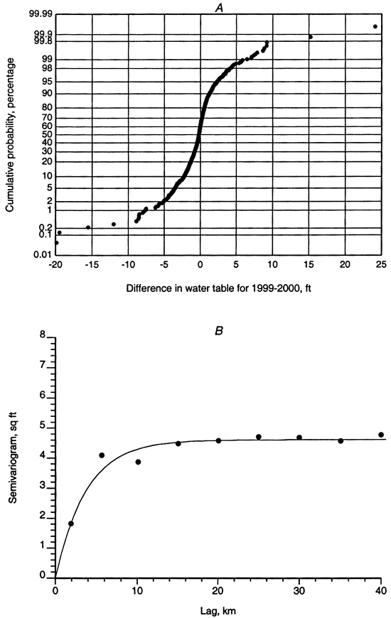
Fluctuations from well to well are somewhat erratic. Consequently, as shown in Figure 1b, the semivariogram has a short range. The best model is exponential with an effective range of 11.2 km and a sill of 4.6 sq ft.
Fluctuations in excess of 10 ft can be considered outliers that should be examined more closely, either to find a cause for the rapid changes in water level to determine if there are unusually pronounced recharge mechanisms in operation, or to verify the correctness of measurements made during the last two years. Wells with increase over 10 ft include wells 1144 and 1516. Wells with declines of more than 10 ft include wells 130, 1621, 1764, 11308.
Relative to the 1998-1999 difference, for 1999-2000 there is an improvement in water table elevations in Rawlins, Decatur, Thomas, Sheridan, Greeley, Meade, Ford, Pawnee, and Edwards County and an increase in the depth to water in areas in Scott, Lane, Rice, Reno, Kingman, and Harvey.
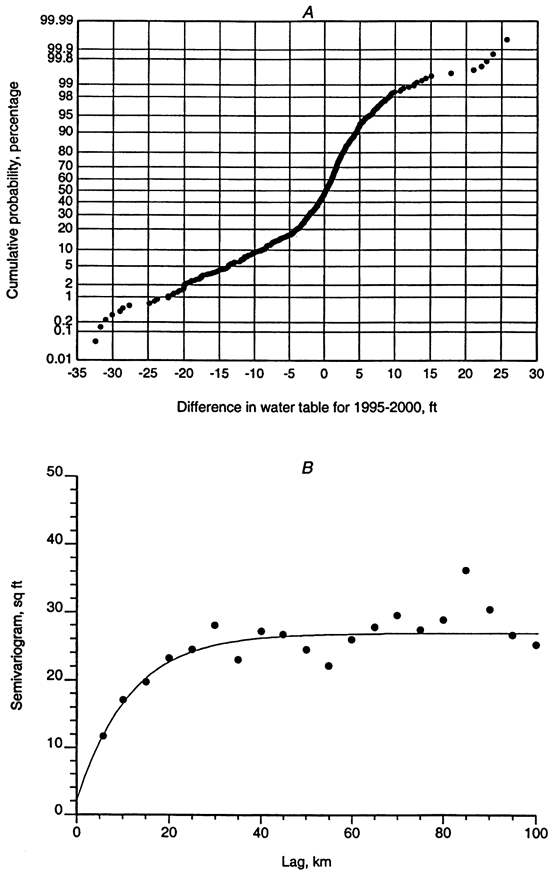
As expected, changes are more pronounced and systematic for 5-year changes in water table elevation from 1995 to 2000. As shown in Figure 2, there are no outliers. The semivariogram model for the residuals along the trend-free N48E direction is exponential with nugget of 2 sq ft, sill of 24-85 sq ft and effective range of 34 km.
Figure 2--1995-2000 differences in water level (A) Cumulative distribution (B) Experimental semivariogram (dots) and semivariogram model for the residuals along N48E (continuous line). The model is exponential with a nugget of 2 sq ft, sill of 24.85 sq ft, and effective range of 34 km.
The most depleted portion of the aquifer continues to be a large area in the southwest corner of the state of Kansas. In terms of increase in water table elevation (recharge), an area in Finney County is larger this year than in the period 1999-1994. The northern portion of the aquifer east of Ford County also shows this year a recharge relative to 1995.
The average increase in depth to water for the 1082 wells with measurements is 1.11 ft (1.38 ft for grid nodes) in Plate 5.
Without making any geohydrological assumptions, several objective conclusions and recommendations can be drawn from the geostatistical analysis of the water-level observation records.
Miller, R. D., Davis, J. C., and Olea, R. A., 1997, Acquisition Activity, Statistical Quality Control, and Spatial Quality Control for 1997 Annual Water Level Data Acquired by the Kansas Geological Survey: Kansas Geological Survey, Open-File Report 97-33, 45 p. [available online]
Miller, R. D., Davis, J. C., and Olea, R. A., 1998, 1998 Annual Water Level Raw Data Report for Kansas: Kansas Geological Survey, Open-File Report 98-7, 275 p., 6 plates, and 1 compact disk [available online]
Olea, R. A., 1984, Sampling design optimization for spatial functions: Mathematical Geology, vol. 16, no. 4, p. 369-392.
Olea, R. A., 1997, Sampling analysis of the Annual Observation water-level wells in Kansas: Kansas Geological Survey, Open-File Report 97-73, 44 p.
Olea, R. A., 1999a, Geostatistics for Engineers and Earth Scientists: Kluwer Academic Publishers, Norwell, Massachusetts, 303 p.
Olea, R. A., 1999b, Optimizing the High Plains aquifer water-level observation network: Kansas Geological Survey, Open-File Report 99-15, 8 p. and 3 plates [available online]
Olea, R. A. and Davis, J. C., 1999, Sampling analysis and mapping of water levels in the High Plains aquifer of Kansas: Kansas Geological Survey, Open-File Report 99-11, 35 p. and 9 plates [available online]
Next page--Appendix A
Kansas Geological Survey, Geohydrology
Placed online Dec. 8, 2010, original report dated March 2000
Comments to webadmin@kgs.ku.edu
The URL for this page is http://www.kgs.ku.edu/Hydro/Publications/2000/OFR00_13/index.html