![]()
Prev Page--Appendices || Next Page--Appendix II
Appendix I--Lithologic and Gamma Ray Logs
Driller's log of a partially rotary drilled and partially cored test hole bored by the Kansas Geological Survey on July 29, 1982, at the Kansas Department of Transportation materials/mixing strip located on the west side of Highway 56/77 less than one mile north of Lincolnville, Kansas, in NE SE NE NW sec. 11, T. 18 S., R. 4 E. Surface altitude, 1,422 feet.
| Thickness, feet |
Depth, feet |
|||
|---|---|---|---|---|
| Soil, sandy, dark brown | 2 | 2 | ||
| Quaternary and/or Tertiary (undif.) | ||||
| Clay, sandy, dark gray-brown | 2.5 | 4.5 | ||
| Clay, sandy, dark red-brown and gray-brown | 1.5 | 6 | ||
| Permian--Leonardian | ||||
| Wellington Formation | ||||
| Shale, red-brown | 2 | 8 | ||
| Shale, gray-green | 2 | 10.2 | ||
| Limestone, dolomitic, tan | 0.8 | 11 | ||
| Limestone, dolomitic, light green-gray, with calcite concretions | 1.5 | 12.5 | ||
| Shale, green | 2 | 14.5 | ||
| Shale, calcareous, tan; contains thin limestones streaks | 2 | 16.5 | ||
| Nolans Limestone Formation | ||||
| Limestone, tan | 1.9 | 18.4 | ||
| Void; circulation lost | 0.5 | 18.9 | ||
| Limestone, dolomitic, very hard, tan to light brown; contains solution vugs (0.5 mm to 5 cm) lined with calcite crystals | 0.8 | 19.7 | ||
| Mudstone, dolomitic, hard, very light tan | 3.3 | 23.0 | ||
| Blind drilling, no samples; drilling was hard and 'crunchy' sounding | 5 | 28 | ||
| Shale, blue-gray; material on drill bit when stopped drilling at 28 ft depth | ||||
Driller's log of a water well drilled with a cable tool rig in Lincolnville, Kansas, by Joe Zinn for Ben Schnieder on October 28-30, 1985, in SW NE SW SW sec. 11, T. 18 S., R. 4 E. Surface altitude, 1,430 feet; depth to water, reported 36 feet.
| Thickness, feet |
Depth, feet |
|||
|---|---|---|---|---|
| Soil | 2 | 2 | ||
| Fill material | ||||
| Clay, light gray | 5.5 | 7.5 | ||
| Sand | 4 | 12 | ||
| Permian--Leonardian | ||||
| Wellington Formation | ||||
| Shale, green | 8 | 20 | ||
| Shale, cavey, yellow | 3 | 23 | ||
| Nolans Limestone Formation | ||||
| Limestone, hard, yellow | 4 | 27 | ||
| Limestone, soft, fractured | 5 | 32 | ||
| Limestone, hard, yellow | 1 | 33 | ||
| Shale, hard, gray | 10 | 43 | ||
| Limestone, hard, light brown, harder at 45 feet | 8 | 51 | ||
| Odell Shale Formation | ||||
| Shale, light blue-green | 5 | 56 | ||
| Shale, red | 2 | 58 | ||
| Limestone | 1 | 59 | ||
| Shale, red | 2 | 61 | ||
| Limestone | 1 | 62 | ||
| Shale, blue-gray | 3 | 65 | ||
| Winfield Limestone Formation | ||||
| Limestone, light tan | 1 | 66 | ||
| Shale, gray | 1 | 67 | ||
| Limestone, light tan | 5 | 72 | ||
| Break; water | 1 | 73 | ||
| Limestone, dolomitic | 2 | 75 | ||
| Shale | 1 | 76 | ||
| Limestone, light gray, hard at 80 ft; very few cuttings--very fine grained from 83.5 to 90 feet | 14 | 90 | ||
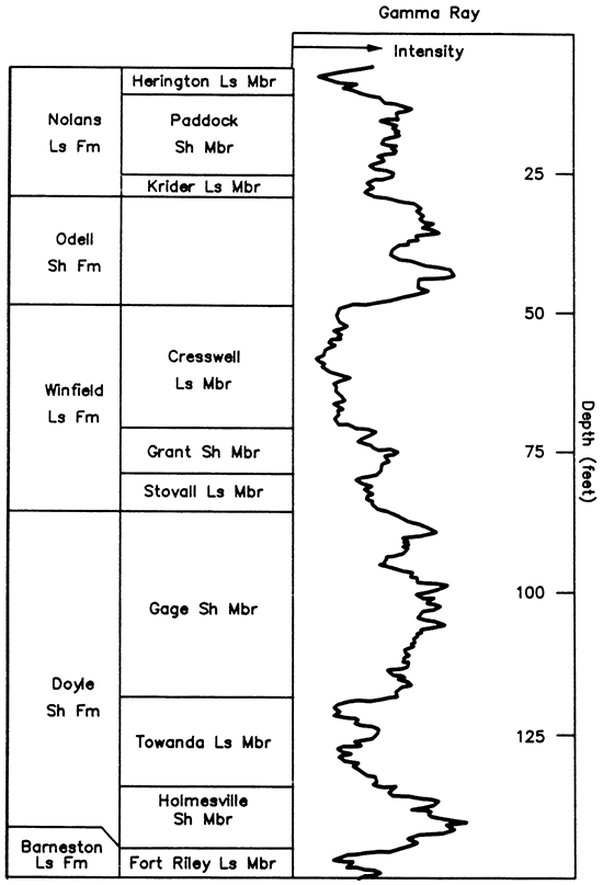
Gamma ray log run on a test hole for Ted Haefner in Lincolnville, Kansas, in the SW SW SE sec. 11, T. 18 5., R. 4 E. Surface altitude approximately 1,415 feet. Date of the log and the company that ran it are not known.
Prev Page--Appendices || Next Page--Appendix II
Kansas Geological Survey, Geohydrology
Placed on web March 16, 2016; originally published 1998.
Comments to webadmin@kgs.ku.edu
The URL for this page is http://www.kgs.ku.edu/Hydro/Publications/1988/OFR88_26/06_append_1.html