


|
|
|
|
|
Below is a translation of an article from the German journal "Zeitschrift für Angewandte Geologie", vol 42, 1996 concerning a liquid hydrocarbon leak through casing in a salt cavern in east Germany in 1988. The translation is by Peter Janda in the University of Kansas Department of Civil and Environmental Engineering, at the request of Dr. Robert Parsons. Permission to post this article, including the figures, was kindly granted by E. Schweizerbart'sche Verlagsbuchhandlung: http://www.schweizerbart.de/.
by Gerhard Katzung, Paul Krull & Freidrich Kühn
A serious leak in the pipe connecting the Teutschenthal underground gas storage cavern with the Lauchstädt 5 pumping station released Ethene. This spread into an aquifer, the Volpriehausen Sandstone, and found its way upwards through the overlying aquitard along a reverse fault, which functioned as a vertical barrier. Thence it flowed into another aquifer, the upper part of the Volpriehausen Formation, an alternating sand and claystone sequence, and spread out laterally, doming up the Pleistocene deposits and finally breaking through them as a mixture of water, ethene, and boulder clay. Both circular and elongated craters were formed, out of which material from the Saalian boulder clay was ejected onto the surrounding fields. The updoming gave rise to gaping fissures several centimetres wide and grabens showing boundary faults of several centimetres displacement. Buildings near the updoming displayed cracks and concrete road slabs were tilted through various angles. The migration path of the ethene-water misture was dictated by the geological structure in the vicinity of the leak, i.e. the NE limb of a gentle dome, its crest block faulted, and movement zones caused by salt tectonics.
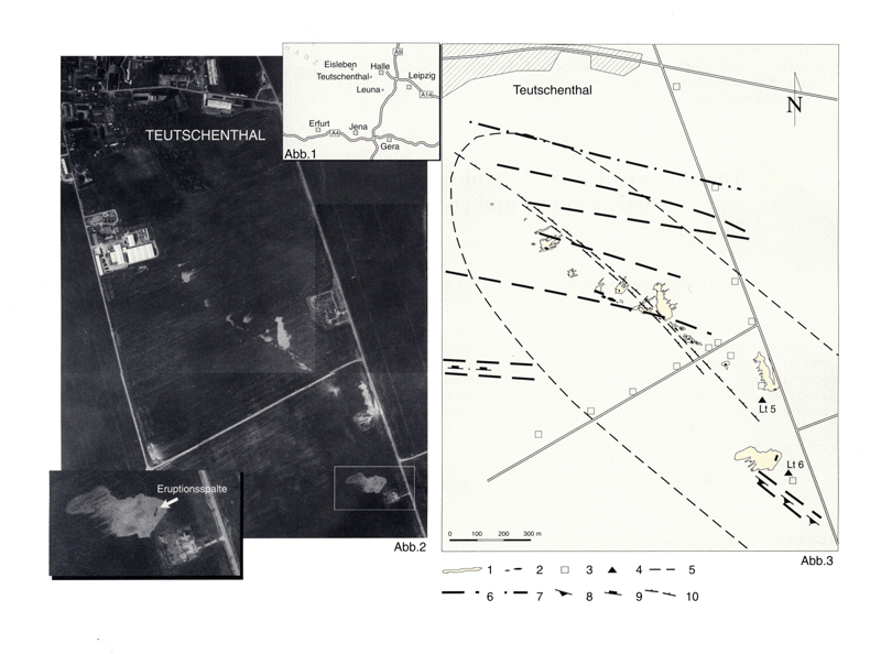
On March 29th, 1988, an ethylene eruption occurred southwest the city of Halle, northwest of a chemical industry location and in the area of the salt cavern underground storage Bad Lauchstädt (picture 1). While the gas was still breaking out, an examination has been conducted, to clarify the causes and the ethylene's migration path. In addition to existing geological records, results from older and operational ordered flights built the main base for the interpretation of the situation, as well as results from fine leveling, conducted right after eruptions started.
Picture 1--Area of the examination area.
Picture 2--Aerial photograph of the disaster area showing the linear alignment
of the ethylene eruptions between the probe (bottom right) and a warehouse south of
the town Teutschenthal.
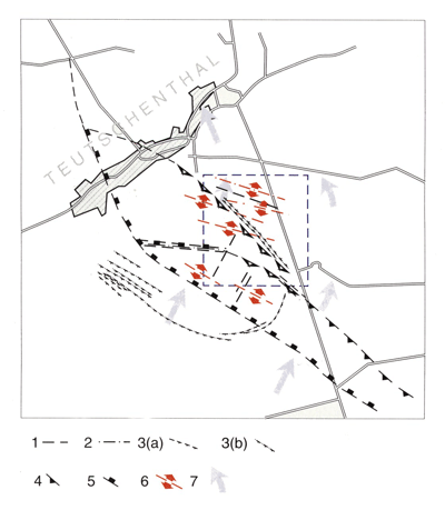
Picture 3--Site plan of the ethylene emissions in regard to the tectonic
inventory:
Due to acute danger of explosions, an area of about 8 km2 around the 2 km long line of emission spots was completely secured. The affected area was easy to overview, as it is agriculturally used. Thus, the outbreak mechanism on day 2 and 3 could be followed well, even from a far safety margin. On April 1st, 1988, the area was walked and examined again for the first time. Small amounts of ethylene were still escaping out of the ground at that point.
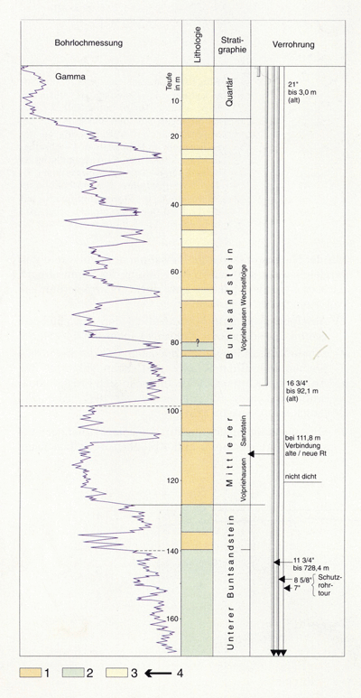
The geological study showed, that natural causes for the disaster could be excluded, especially also a possible eruption directly from the cavern, as the cavern had a powerful intact upper sealing (mainly rock salt and clayey rock) and a fault-free cementation of the "pipe tour" in this section, at the time of the probe installation. Large ethylene emissions in a drinking water well, close to probe 5 in about 100-140 m depth and on the level of an aquifer, indicated leakage in that "pipe tour" section though. Later examinations concluded that a leaky pipe connection of the 11.75" "pipe tour" in 111.8 m depth caused direct inflow into the ground water.
In regard to the spreading of the ethylene, the eruptions occurred in a linear way, in several parallel rows. This was verified through infrared measuring using helicopters and panchromatic aerial photographs, shot during the eruption phase (pictures 2 and 3). Out of the more or less permanent, partly pulsating ethylene-water-fountains, pieces of gravel, sands and marly till were disgorged and spread on the acres (see picture 2).
The ethylene apparently moved upward, over linear breaking and loosening zones, out of the aquifer through the overlying sandstone to the Pleistocene (picture 5). There, it spread out, cambered, and eventually broke out of the ground surface in the described linear way.
The intensity of the eruptions decreased a lot within a few days, conditional on the emptying of the cavern. Ebullient springs and weak ethylene-exhalations (glimmering air, smell) out of openings were proofs for the remaining small pressure differences between the cavern and the ground surface. The eruption ended, after 60 to 80% of the cavern filling escaped.
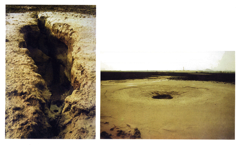
Picture 4--Site photograph of the ethylene outbreak spots:
The lower sand stone strata is almost 300 m thick and consists mainly of deposited silty and clayey stones with little, fine-grained sandy stones, that show a small-cyclical formation. The upper sand stone strata is also about 300 m thick.
Picture 5--Schematic view of the storage and cover in the zone of the probe:
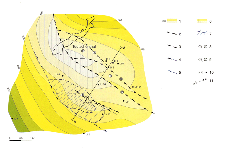
Picture 6--Structural pattern of the "sub- and suprasalinars":
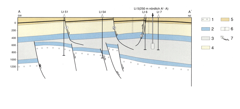
Picture 7--Cross-section A-A' (see picture 5) through the Lauchstädt structure.
Picture 8
The ethylene's emission out of the "pipe tour" occurred about 110 m below the ground, in the sand stone strata of 30 m thickness. From there, most of it migrated laterally corresponding to the structural rise of the layers in a west-northwest direction, up to the reverse fault (fault no. 4 in picture 6). The eruptions in the area of fault 3 and 4 were caused by local fractions, close to probes Lauchstädt 5 and 6.
Due to the build-up of ethylene at the reverse fault at the clayey, silty lower sand stone, the migration was redirected to the northwest. The build-up also caused the rise of the ethylene at that point on the one hand, between the lower southwestern sand stone and the covering alternation, and on the other hand the transfer into the upper, sandy alternation up to the level of the Pleistocene. In that progress, at least the upper part of the Pleistocene got bent, on both sides of the reverse fault, and quasi symmetrical, on a calotte-shaped area that's 750 m wide and more than 1.5 km long, before eruptions began.
The meanwhile developed ethylene-water-mix broke through the Pleistocene and picking up solids there, over the reverse fault in the center of the calotte. In the northwest and southeast of the disaster area, the arrangement of the eruption spots shows a direct connection to the fault direction.
The key role for the ethylene's outbreak is fault no. 4, as the northeastern margin of Kippscholle II. It built a barrier for the lateral migration in the Volpriehausen sand stone and opened the way for a migration upwards. In acute-angled to the reverse fault's area located distortion zones, the upward movement continued into the sandy Volpriehausen alternation. From there, the gas-water mix passed on into the quaternary cover layers, cambered them, and broke out in the described way at the ground surface.
Right after the incidence, the question was if any weak zones exist outside the linear arranged eruption line. Geophysical and other ground supported examination methods could not be used, due to the high risk. In this case, the photo-geological analysis of the area was the only method suitable to gain information within 1 or 2 days, necessary for catastrophe management. Together with other already existing information, it could be said that the probability for further weak zones as potential eruption areas outside the eruption line was very low. This lead to the decision not to evacuate parts of the town Teutschenthal.
Prev Topic--Yaggy Field || Next Topic--Shallow Seismic Reflection Survey