Report
A Loiczview
Application to Map Enviromental Proxies for Coral Reef Distribution in Mexico,
Central America and the Caribbean
By: Jose D. Carriquiry
(May 1, 2001)
DESCRIPTION OF CLUSTERING
PROCEDURES:
The
Loiczview porgram was initially used for zones 9 + 10, using many different
atmospheric, geomorphic and coastal variables during the first clustering
attempts.
Variables
were systematically eliminated until a minimun set was established that was
capable of creating clusters related to coral reefs distribution. The critical
variables needed to generate coral reef distribution clusters were: (1) Average
Elevation Bathimetry; (2) Average Minimum SST, (3) SST Range (max-min), (4)
Minimum Monthly Salinity, (5) Maximum Monthly Runoff.
Variables
had to be weighted: 3xSST_Range and 2xMin_Monthly_Salinity.
The
number of clusters was also critical. It was found that 5 clusters using these
variables always yielded more realistic cluster separation.
RESULTS:
1.
Two clusters were needed to explain the distribution of most of the Pacific and
Caribeean coral reefs (East Pacific
coral reefs did not fall in the same cluster as those from the Mexican
Caribbean, although many other Caribbean coral reefs did).
2.
The distribution of most Coral Reefs in the Eastern Tropical Pacific was
strongly related to a steep bethimetric slope (i.e., average elevation
bathimetry). Apparently, coastal areas off the southern tip of Baja California,
off cabo Corrientes (Puerto Vallarta), off the western Mexican coast, off
Central America (Honduras, Costa Rica and Panama), as well as off all the
oceanic islands (Revillagigedo, The Galapagos and Hawaii) present a steep
slope. This can be thought as an opposite variable to gentle sloping offshore
areas that usually are associated to mangroves, coastal lagoons, coastal plains
and beaches. All these latter coastal types would prohibit coral reef
development. That is why, coral reefs are more commonly associated to steeper
bathimetric relief. Most of the coral reefs in the Caribbean seem to be related
to this type of coastal submarine geomorphology.
3.
The second coral reef cluster explain additional (but not all) coral reefs off
the Yucatan penninsula.
4.
Of the five clusters formed, cluster 3 and 4 (the two that clustered areas
populated by coral reefs) showed the greatest similarity between them. Cluster
3 (Caribbean + Pacific) had a gentler slope than cluster 4 (Pacific). However,
both clusters showed in common: (1) intermediate values in mean monthly SST
(26.3 to 27.3 C); (2) showed lowest SST variability with a range of 5.1 to 5.4
C (more stable, thermally); (3) Minimum Salinity was 34.9 to 35.0; (4)
intermediate runoff. Runoff, however, did not seem to contribute much to the
clustering (eliminating it did not change too much the distribution, but
keeping it in presented a slightly better distribuion)
5.
The variables used for establishing clusters with a distribution resembling
those of coral reefs are shown below.
STATISTICS:
|
Variables Used: |
Cluster 3 |
Cluster4 |
Cluster's Mean |
|
|
Cluster Symbol Color |
PINK |
Light BROWN |
Mean |
StdDev |
|
Region |
Pacific |
Pacif+Caribbean |
|
|
|
AVG_ELEV_BATH: |
-1380.95 |
-3010.12 |
-2195.54 |
1151.997 |
|
SST_MEAN_MONTHLY: |
27.2563 |
26.3279 |
26.7921 |
0.656478 |
|
SST_MIN_MAX_RANGE: |
5.16679 |
5.48952 |
5.328155 |
0.228205 |
|
SALINITY_MIN_MONTH: |
35.0171 |
34.9731 |
34.9951 |
0.031113 |
|
RUNOFF_MAX_MONTH: |
107.89 |
83.5653 |
95.72765 |
17.20016 |
6.
The cluster map showing the distribution is:
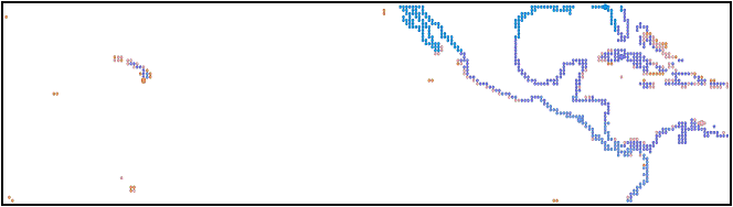
Note: In order to clearly
see the colors for the resulting clusters, please increase the zoom (upper
right corner of Word menu) to 200%. The resulting clusters that coincide with
areas known containing coral reefs are: BROWN (Pacific Islands: Hawaii,
Revillagigedo, Galapagos) and PINK (Fringing Pacific and Caribbean coral
reefs).
7.
In order to see how well the set of variables obtained to cluster coral reef
areas in the Pacific and Caribbean worked in other reefs of the world, a new
attempt was made using the same set of variables (with the same weighting as
before) to map the coral reefs off Australia and Oceania. As a refresher, the
variables used (and their weight) is given next: Avg_Elev_Bath (1x),
SST_mean_monthly (1x), SST_Min_Max_Range (3x), Sal_Min_Month (2x) and
Runoff_Max_Month (1x). Also, because the Great Barrer Reef in Australia is not
a fringing reef system that could be found in the coastal cell, this reef
system is located offshore in the first oceanic cell. For this reason, in
addition to the coastal cell, the new clustering attempt for Australia and
Oceania included also the first oceanic cell. The results obtained are somehow
encouraging. One cluster (cluster # 7, Light BROWN color symbols) was obtained
that followed the distribution of coral reefs in the Australia-Oceania region.
This cluster maps some of the most important coral reefs in: the Great Barrier
Reef (Australia), New Guinea, New Caledonia and Vanuatu, Fiji, and Indonesia in
lesser extent.
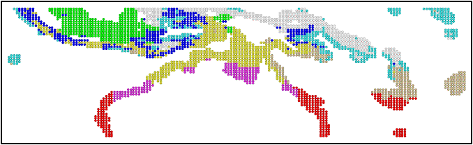
Note:
see the distribution of cluster #7 (Light BROWN) and cluster #6 (light BLUE) as
a proxy of the coral reefs in this region. Increase the zoom to 200% in order
to clearly see this cluster off NE Australia (GBR), New Guinea and Indonesia.
8. The average value for each of the variables in this cluster
|
Variables Used |
Cluster 6: |
Cluster 7: |
|
Clusters-mean |
|
|
|
mean |
Mean |
|
Mean
|
StdDev |
|
AVG_ELEV_BATH: |
-4269.66 |
-2150.56 |
|
-3210.11 |
1498.43 |
|
SST_MEAN_MONTHLY: |
28.7171 |
26.9835 |
|
27.8503 |
1.22584 |
|
SST_MIN_MAX_RANGE: |
3.99973 |
5.30375 |
|
4.65174 |
0.922081 |
|
SALINITY_MIN_MONTH: |
34.1381 |
34.7829 |
|
34.4605 |
0.455942 |
|
RUNOFF_MAX_MONTH: |
405.5 |
321.774 |
|
363.637 |
59.20322 |
9.
The average value for each of the variables in this cluster are somewhat
similar considering the overall variability in the settings of the regions
under comparison (SE Asia, Australia and Oceania versus Eastern Tropical
Pacific and Caribbean). The main differences are in the existing runoff (larger
in SE Asia, NE Australia and Oceania) as well as in the bathimetric relief
(larger also in the latter region because of geomorphology of tectonic basins
upon which reefs develop).
|
Variables Used |
Pacific+ Caribbean |
Australia+ Oceania |
|
AVG_ELEV_BATH: |
-2195.54 |
-3210.11 |
|
SST_MEAN_MONTHLY: |
26.7921 |
27.8503 |
|
SST_MIN_MAX_RANGE: |
5.328155 |
4.65174 |
|
SALINITY_MIN_MONTH: |
34.9951 |
34.4605 |
|
RUNOFF_MAX_MONTH: |
95.72765 |
363.637 |
10.
Limitations.
a)
Nota all Coral Reefs could be map effectivelly. The coral reefs off the Eastern
and Western coasts of Yucatan, Belize and the Florida Keys could not be mapped
with the other coral reefs obtained in the coral reef clusters.
b)
A proxy for water clarity/turbidity would help in improving the mapping of
coastal waters suitable for coral reef development. Probably chlorophyl data
(from CZCS or Seawifs) would help to discriminate more productive waters (which
are less clear than coral reef waters).