![]()
Prev Page--Contents || Next Page--Geography
Introduction
Purpose and scope of the investigation
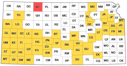
A program of investigation of the ground-water resources of Kansas was initiated in 1937 by the State Geological Survey at the University of Kansas and the United States Geological Survey, in cooperation with the Division of Sanitation of the Kansas State Board of Health and the Division of Water Resources of the Kansas State Board of Agriculture. It is the purpose of this program to make detailed surveys of county areas and major stream valleys or irrigation districts where ground-water supply problems are acute. The present status of investigations resulting from this program is shown in Figure 1.
Fig. 1--Index map of Kansas showing area described in this report and areas covered by other online geologic reports, as of July 2008. For additional information, please visit the KGS Geologic Maps of Kansas Page.
As a part of these investigations, a study of the geology and ground-water resources of Norton County was initiated during the summer of 1945. Test drilling to determine the character and thickness of the water-bearing formations and the measurement of water levels in many existing private wells were carried out during 1946. In 1947 the Federal Geological Survey undertook, at the request of the United States Bureau of Reclamation, a detailed investigation of the ground-water supplies in the Prairie Dog Creek Valley of eastern Norton County and northwestern Phillips County. This area comprises the Bureau of Reclamation's Almena project area. As this investigation overlapped a part of Norton County, the two studies are combined in this report.
In Norton County and adjacent northwestern Phillips County, as in much of the western half of Kansas, ground water constitutes one of the most important mineral resources. Although this area is crossed by three perennial streams--the North Fork of Solomon River, Prairie Dog Creek, and Sappa Creek--nearly all public, railroad, irrigation, and domestic water supplies are obtained from wells. There is therefore, a definite need for an adequate understanding of the quantity and quality of the available supply, where and how additional supplies can be obtained, and what measures may be necessary to safeguard their continuance.
This investigation was made under the general supervision of A. N. Sayre, Geologist in Charge of the Ground-Water Branch of the Federal Geological Survey. That part of the investigation relating to the Almena area was also under the general supervision of George H. Taylor, Regional Engineer, Ground-Water Branch.
Location and extent of the area
The area covered by this report is located in the Plains Border section of the Great Plains physiographic province (Fenneman, 1931). It is in the northern tier of Kansas counties adjacent to the Nebraska State line, and is bounded on the west by Decatur County on the south by Graham County, and on the east by adjacent parts of Phillips County. Most of the area lies between 39° 28' and 40° 00' north latitude and 99° 21' and 100° 12' west longitude. It contains more than 27 townships, from T. 1 S. to T. 5 S., and from R. 18 W. to R. 25 W. It has an area of approximately 1,000 square miles.
Previous investigations
In the northwestern part of Kansas only Thomas County has been covered by a cooperative county ground-water report (Frye, 1945) published as Bulletin 59 of the State Geological Survey. A comparable report, has been published on Scott County, which lies in the fourth tier of counties south from the Nebraska line (Waite, 1947), and a specialized report on the occurrence of ground water in the oil-field areas of Ellis and Russell counties, which lie to the southeast of Norton County (Frye and Brazil, 1943). A reconnaissance of ground-water resources in Rawlins and Decatur counties was published as Mineral Resources Circular 7 of the State Geological Survey (Elias, 1937), and a detailed report on the geology of Wallace County, which contains some data on ground-water supplies, was published as Bulletin 18 of the Geological Survey (Elias, 1931). Field investigations of the ground-water resources in the North Solomon Valley across Phillips, Smith, and Osborne counties have been completed by A. R. Leonard, and a report on the geology and ground-water resources of Jewell County is in preparation. In addition, several regional studies (Haworth, lS97; Johnson, 1901; Darton, 1905) touch upon the geology and underground-water supplies of this area.
The earliest report on the geology of Norton County was prepared by Robert Hay and was published in 1885 in the Transactions of the Kansas Academy of Science (pp. 16-24). The paper was read before the Academy at its Topeka meeting in 1883 and the clarity with which Hay presented the essential features of the geology of Norton County is striking for such an early date. It should be noted that the deposits referred by him to the Miocene are here classed as Pliocene and referred to the Ogallala formation, and the deposits he classed as Pliocene are here classed as the Pleistocene and referred to the Sanborn formation.
Methods of investigation
The geology of the area was studied and mapped (Pl. 1) during two months of field work in 1945, three weeks each in 1946 and 1947, and a week during the spring of 1948. A partial inventory of existing water wells was made in Norton County during 1946 by John Sears and Milton Sears. Delmar Berry measured the water level in additional wells in the Prairie Dog Valley area of Norton and Phillips counties during 1947 and has made measurements of observation wells since that time.
The character of the material below the land surface was determined by the drilling of 64 test holes through the entire thickness of water-bearing sand and gravel and into the underlying Cretaceous shales and chalks. These test holes were drilled with the hydraulic rotary drilling machine owned by the State Geological Survey of Kansas and operated by James Cooper and William T. Connor during the season of 1946 and by Connor and Glenn Prescott during the season of 1947. Logs of the test holes were prepared in the field by Cooper and Prescott; these were later supplemented by microscopic examination of the well cuttings. By using a plane table and alidade, level parties headed by Charles K. Bayne and Delmar Berry determined the altitude of the measuring point of wells in which water levels were measured and the altitude of the surface at the test-hole locations.
Wells shown on Plate 2 were located within the sections by use of the odometer. The two figures shown adjacent to well locations on Plate 2 refer to the altitude of the water table and the depth to water below the land surface, the figure above the line being altitude and that below the depth to water. Brackets placed around the bottom figures indicate that a chemical analysis of water from the well is given in the report (Tables 5 and 6).
Samples of water from 45 wells in the county were collected and chemical analyses of them were made by Howard Stoltenberg, chemist in the Water and Sewage laboratory of the Kansas State Board of Health, or by chemists of the Quality of Water Branch of the Federal Geological Survey at Lincoln, Nebraska.
The base map of the county used in Plates 1 and 2 was compiled by Bernita Mansfield and Grace Muilenburg from aerial photographs and county maps of the Soil Conservation Service, and aerial photographs from the Agricultural Adjustment Administration, United States Department of Agriculture, and from county maps prepared by the State Highway Commission of Kansas. Geologic mapping in the field was done on a base map at a scale of one inch to the mile. This field mapping was supplemented by stereoscopic study of aerial photographs along all the major valley areas.
Well-numbering system
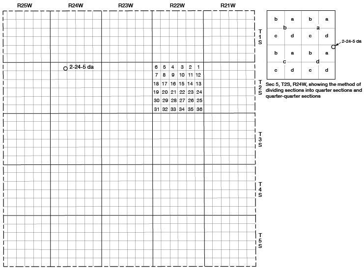
The well and test-hole numbers used in this report give the location of wells according to General Land Office surveys and according to the following formula: township, range, section, 160-acre tract within that section, and the 40-acre tract within that quarter section.
If two or more wells are located within a 40-acre tract, the wells are numbered serially according to the order in which they were inventoried. The 160-acre and 40-acre tracts are designated a, b, c, or d in a counter-clockwise direction beginning in the northeast quarter. For example, well 2-24-5da (Fig. 2) is located in the NE SE sec. 5, T. 2 S., R. 24 W.
Fig. 2--Map of Norton County illustrating the well-numbering system used in this report.
Acknowledgments
Appreciation is expressed to the many residents of Norton County and northwestern Phillips County who supplied information and aided in the collection of field data. Special thanks are extended to the owners of several irrigation wells, who furnished us with information concerning their well-pumping plants; to the city officials of Long Island, Almena, Norton, Lenora, and Clayton for data on municipal water supplies; and to the several water-well drillers operating in the area, who have furnished logs and other pertinent data concerning the installation of water wells. M. K. Elias of the Nebraska Geological Survey spent several days in the field and kindly identified the fossil seeds collected from the Ogallala formation. A. Byron Leonard identified the fossil snails from the Pleistocene deposits of the area, and C. W. Hibbard identified several fragmentary fossil vertebrates.
Frank Byrne and assistants in the section of Engineering Geology, U. S. Geological Survey, spent several days in the field with us and furnished a copy of their geologic map of Phillips County.
The manuscript of this report has been reviewed critically by several members of the Federal and State Geological Surveys; by Dwight Metzler, Director and Chief Engineer, and Ogden S. Jonees, Geologist, Division of Sanitation, Kansas State Board of Health and by George S. Knapp, Chief Engineer, and R. V. Smrha, Assistant Chief Engineer, Division of Water Resources, Kansas State Board of Agriculture.
Prev Page--Contents || Next Page--Geography
Kansas Geological Survey, Geology
Placed on web July 18, 2008; originally published Dec. 1949.
Comments to webadmin@kgs.ku.edu
The URL for this page is http://www.kgs.ku.edu/General/Geology/Norton/02_intro.html