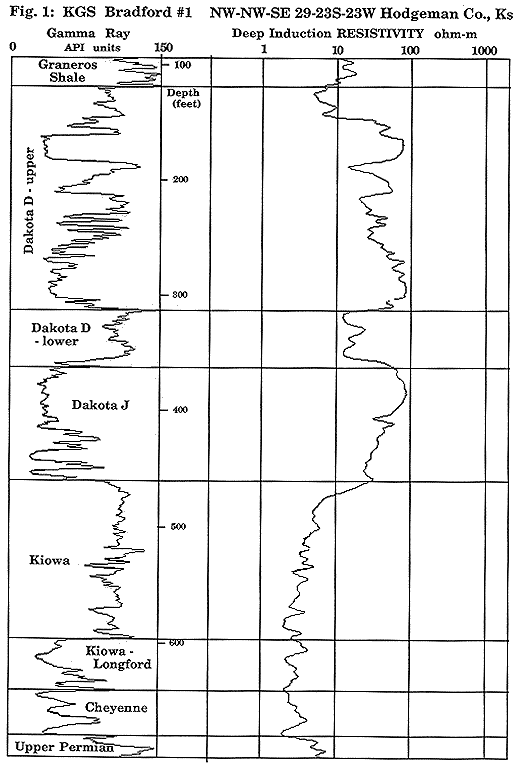
Sequence stratigraphy is the study of rock relationships within a framework of repetitive, related sedimentary deposits (sequences) bounded by erosional surfaces or surfaces of nondeposition (sub-aerial unconformities). The bounding unconformity formed as a consequence of a global drop of sea level. Using the log data base (Figure 1), the intervals comprising the Dakota aquifer were subdivided into component sequences and related to their environment of deposition, such as deltaic, coastal plain, fluvial, etc. The sequence was subdivided into systems tracts of related depositional environments. Numerous maps and cross sections displaying the interpretations of the Dakota interval were constructed. The data and maps resulting from the sequence stratigraphy study will lead into an analysis of porosity and permeability distribution, into an investigation of possible relations between aquifer properties and depositional environment, and into a preliminary computer simulation of the geohydrology of the Dakota.
Figure 1
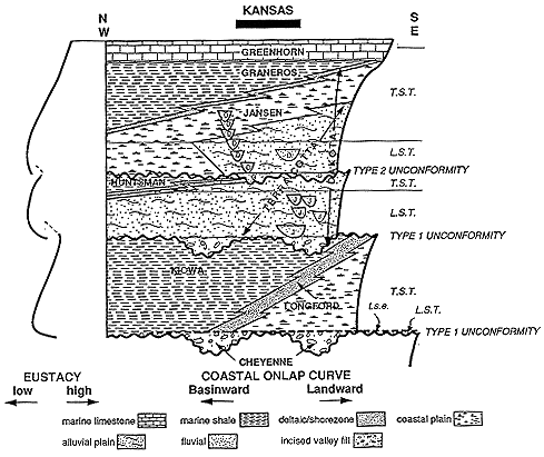
The components of a stratigraphic sequence occur (Figure 2) as a result of the global sea level (eustatic) rise and fall. Major global sea level falls cause incision of fluvial valleys and the formation of a major, regional, subaerial erosional surface or unconformity (Type 1 unconformity) on continents. Deposition during the low-level stillstand of the sea and during the early part of a subsequent rise in sea level infills the incised river valleys on land; shoreline and marine sediments accumulate in a normal progradational manner. Deep marine turbidite fans, incised valley fill (ivf), and the progradational comlex are grouped into a lowstand systems tract (LST). A minor drop in sea level also results in a regional subaerial erosional surface (Type 2 unconformity) but does not induce strongly incised fluvial systems. This minor fall in sea level rejuvenates the river systems and basal fluvial deposits are coarser grained than the sediments underlying the unconformity. As sea level starts to rise after a fall, progressively more marine sediments are deposited in a transgressive systems tract (TST). During the high-level stillstand of the sea, sediments are deposited in a progradational mode and the shoreline advances seaward through time; these deposits are the highstand systems tract (HST), the uppermost unit of a sequence, which is not preserved in the Dakota aquifer.
Figure 2
The Dakota aquifer is bounded at its base by a major erosional surface, a Type 1 unconformity (follow on Figure 2). The Cheyenne Formation overlying the unconformity is an incised valley fill deposit. Above a transgressive surface of erosion (t.s.e.), the Kowa-Longford section above the Cheyenne is comprised of marine and shoreline sediments of the transgressive systems tract. Another major drop in sea level formed the Type 1 unconformity/sequence boundary that separates the Kiowa from the overlying Dakota Formation. The basal J sand of the Dakota Formation was deposited as incised valley fill. In extreme northwestern Kansas the remnant of the marine deposits of the transgressive systems tract is preserved as the Huntsman Shale. A minor fall of sea level followed the incursion of the Huntsman Sea and developed a Type 2 erosional boundary. The lowermost D sands are the coarse basal fluvial deposits of a lowstand systems tract. The transgressive systems tract, the marine Graneros Shale, was deposited in a sea that flooded over the coastal plain clay of the Janssen Member that, in turn, overlaid the alluvial plain deposits of the Terra Cotta Member of the Dakota Formation. The uppermost unit in this transgressive systems tract is the Greenhorn Formation, deposited at the time of maximum transgression with little sediment influx; it is known as a condensed, sediment starved, section (CS). Highstand systems tracts are not present in the Dakota aquifer, due to either non deposition or erosion.
Previous paper--Macfarlane || Symposium Index || Next paper--Wade