


Kansas Geological Survey, Open-File Rept. 96-1a
Proposed Management Areas--Page 11 of 16
Confined Dakota aquifer diffusivities are higher in the eastern part than in the western part of this management area (Macfarlane, in review). Thus the shared boundary with Management Area Va is closer to the edge of the confined aquifer in the western part than in the eastern part of the management area.
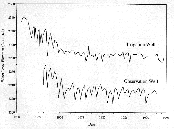
The hydrographs of wells in this management area suggest that significant induced recharge will occur within a 20 yr planning horizon. Figure 10 shows the location of an observation well (A) and a nearby production well (B) located approximately 6 mi away. Both wells are located in Ford County and are screened in the upper Dakota aquifer. The production well is located 5 mi away from where the Dakota is hydraulically-connected to the High Plains aquifer to the south. The observation well is located about 4 mi away from where the Dakota discharges to Saw Log Creek to the north. The production well is an irrigation well that has been in intermittent operation since 1967.
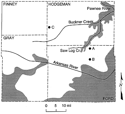
Figure 10. Location of the Hodgeman and Ford County wells discussed in this part of the paper. Well A is located in NW, NW, NW Sec. 12, T. 25 S., R. 23 W., Well B in SE, NE, SE Sec. 10, T. 26 S., R. 23 W., and Well C in SW, SW, SW Sec. 7, T. 23 S., R. 26 W. The shaded areas on the map indicate areas of hydraulic connection with the Hight Plains or the alluvial aquifers in the Pawnee River drainage.
The hydraulic heads in both the production and the observation wells show a decline within the confined aquifer for the first 9 yrs of record until 1976 (Figure 11). During this period withdrawals were removing water from storage in the confined Dakota. After 1976 the hydraulic heads are fairly stable except for the seasonal fluctuations up to the present indicating that the hydraulic-head declines in the aquifer had reached the area of hydraulic connection with the High Plains aquifer and the local discharge area in Saw Log Creek. During this time, continued withdrawals have increased the recharge from the High Plains to the Dakota or reduced the discharge or both to sufficiently stabilize water levels in the Dakota.
Figure 11. Hydrographs of a production well and an observation well in the upper Dakota aquifer of Ford County, Kansas. The wells are approximately 6 miles apart. Water-level declines during the early phase of development induce flow into the Dakota aquifer from the High Plains aquifer eventually creating a new equilibrium within the aquifer.
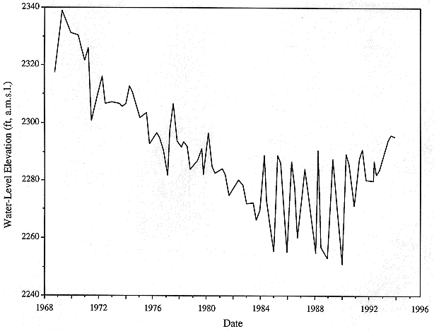
Another similar example comes from the upper Dakota aquifer in western Hodgeman County, Kansas (Figure 12). The well is located 17 mi from the area of hydraulic connection with the High Plains aquifer in Gray County to the south and 22 mi away from the local discharge point beneath the alluvium in the Pawnee River valley to the east. The hydrograph shows a steady decline of hydraulic head in the confined Dakota from 1968 to 1983, a period of 15 yrs. The period following is one of fluctuating water levels associated with the seasonal pumping during a period of hydrologic stability. As in the previous example, the data suggest that ground water was being removed mostly from storage until about 1983. After 1983, a sufficient amount of induced recharge was added to the aquifer to stabilize the hydraulic head in the aquifer and, as in the previous example, establish a new dynamic equilibrium between recharge to and discharge from the aquifer.
Figure 12. Changes in hydraulic head in an observation well from 1968 to 1994. The well is screened in the upper Dakota aquifer in Hodgeman County, Kansas, and is in use seasonally as a high capacity well.
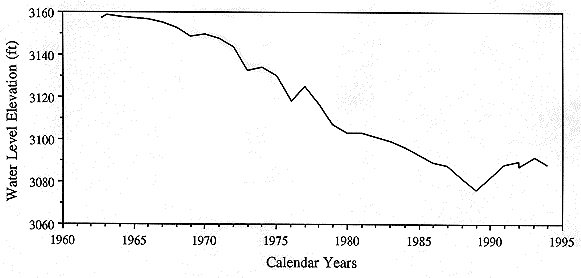
Farther west in Hamilton County, the hydrograph of a stock well in the Dakota aquifer located north of the Arkansas River valley shows similar trends (Figure 13). The time period from 1963 to 1989 the hydraulic head was declining. However, after that time the hydraulic heads seem to have stabilized. The Dakota is hydraulically-connected to the overlying alluvial aquifer in the valley approximately 5 mi to the south. The proximity of the well to upgradient source of recharge suggests that pumping has induced significant recharge into the Dakota from the overlying alluvium.
Figure 13. Hydrograph of a well in the Dakota aquifer in SE, SE, NW Sec. 29, T. 23 S., R. 40 W.
Many of the high-yielding wells in the upper Dakota are currently located in Management Area II. The most important water-resources issue is loss of water from the overappropriated High Plains aquifer and some of the alluvial aquifers caused by ground-water withdrawals from the confined Dakota aquifer. Additional development in this part of the aquifer will gradually increase the water loss from storage in the shallow aquifers and should have a minor impact onstreamflows. Using a management model of the Dakota and High Plains aquifers in Hodgeman, Finney, Kearny, Ford, and Gray counties, Watts (1989) demonstrated that even at low levels of development induced recharge is the major source of water to pumping wells in the Dakota where the Upper Cretaceous aquitard is present. Watts found that after a 20 yr period of annually increasing development, 81% of the water from the Dakota was derived from the High Plains aquifer and only about 19% was from storage in the Dakota aquifer even with a 5 mi buffer zone near the subcrop boundary. Looking only at the water resources in the Dakota aquifer, the 4 mile well spacing appears to be appropriate for this management area. Additional controls, such as increased well spacing and regulation of withdrawal rates, may be needed in the future if the pace of development increases.
Previous page--Management Area I ||
Next page--Management Area III
Start of this report ||
Table of Contents