Dakota Home Report Archive Report Start

Kansas Geological Survey, Open-File Rept. 96-1a
Proposed Management Areas--Page 2 of 16


The Geologic Framework of Dakota Aquifer System

The Dakota aquifer system is the most geographically extensive of all the aquifer systems in the upper 2,000 ft of the subsurface of western and central Kansas (Figure 1). The geologic units that form the Dakota aquifer in Kansas are the Dakota Formation, the Kiowa Formation, and the Cheyenne Sandstone (Table 1). The combined thickness of these units can ranges up to more than 700 ft in west-central parts of Kansas. At the regional scale, the Dakota aquifer system consists of upper and lower units separated over much of Kansas by the Kiowa shale aquitard.

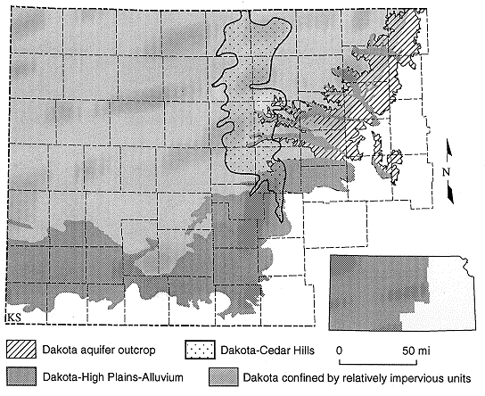
Figure 1. Extent of the Dakota aquifer in Kansas showing regions of hydraulic connection to other aquifers, where the Dakota is a near surface aquifer, and where it is confined by relatively impervious units.

figure1

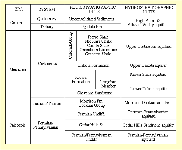
The proportion of sandstone to the total thickness of the stratigraphic units that constitute the Dakota aquifer is approximately 30% statewide. However, locally this proportion can vary widely from less than 5% to more than 50% over short distances. The sandstone aquifers contained in these Cretaceous units occur as irregular, discontinuous bodies within the mudstone and generally occur in several, more or less distinct zones.

Table 1. Stratigraphy and hydrostratigraphy of the shallow subsurface in western and central Kansas.

table1

Previous page--Introduction || Next page--Other Significant Aquifer/Aquitard Units
Start of this report || Table of Contents


Kansas Geological Survey, Dakota Aquifer Program
Original report available from the Kansas Geological Survey.
Electronic version placed online July 1996
Scientific comments to P. Allen Macfarlane
Web comments to webadmin@kgs.ku.edu
URL=http://www.kgs.ku.edu/Dakota/vol3/ofr961a/man02.htm