


Kansas Geological Survey, Open-File Rept. 93-1B
Statistical Methods for Delineating
Water Quality--Page 4 of 5
Many of the analyses in zone I (north-central Kansas; fig. 1) plot as the freshwater group (chloride <250 mg/L) in the discriminant analysis (figs. 4 and 5) and in the calcium bicarbonate region of the trilinear diagrams (fig. 2). This is expected because the Dakota aquifer is shallow in these areas of the state and has been flushed by freshwater recharge. However, in this region numerous samples show high chloride concentration (fig. 2). These analyses indicate areas of saltwater intrusion caused by discharge of water from local flow systems in stream valleys. In these discharge zones salt marshes, salt springs, and salt affected streaches of streams are common hydrologic terrains (Macfarlane et al., 1988).
Saltwater intrusion from underlying Permian formations to the Dakota Formation and from the Dakota to alluvial aquifers can occur where the depth to the Dakota is shallow in the river valleys. However, well depths can be relatively shallow in the valleys and greater in the uplands without appreciable changes in the salinity in some locations which would explain the low correlation between depth and chloride concentration seen in both the Kendall and Spearman tests (Table 4).
Zone 2
In the interior tier of counties (zone 2, fig. 1) the Kendall and Spearman tests show the strongest correlation of chloride with depth (table 4). The discriminant analysis shows that most of the wells with chloride > 1500 mg/L fall within this area of Kansas (figs. 4 and 5). The trilinear diagram (fig. 3) also indicates a predominance of sodium chloride waters in the central part of the state.
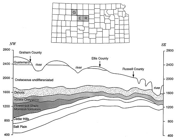
In this region the underlying Kiowa Shale and the Permian Morrison formation pinch out, with the result that the Dakota is hydraulically contacted to the underlying Permian Cedar Hills Sandstone (figs. 8 and 9). The Cedar Hills saline water dischages into the overlying Dakota. In addition, this area is located on the Central Kansas uplift, which may have caused fracturing and thus produced potential pathways for migrating fluids (Macfarlane et al., 1988). Isotope analysis at several sites in this area help to confirm this hypothesis (Townsend et al., 1989).
Figure 8. Stratigraphic column for study area.
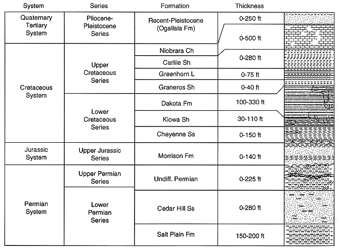
Figure 9. Cross section through Graham, Ellis, and Russell counties showing subsurface stratigraphy.
Zones 3 and 4
The western and southwestern tiers of counties (zones 3 and 4, figs. 2 and 3) also show a significant correlation of chloride concentration with depth, although the low value suggests that the correlation is not strong (table 4). The result of a significant low correlation suggests that other factors besides depth have a strong influence on the occurrence of saline waters in these areas.
The southwestern tier of counties (zone 4) is similar to the north-central tier in that the wells are located in the subcrop and outcrop zones of the Dakota, are fairly shallow, and are probably influenced by the effects of freshwater recharge from rainfall or downward flow from the Ogallala formation. Portions of these counties have saline intrusion because of the pinching out of shales and contact with underlying Permian units (figs. 8 and 9). Sodium bicarbonate and mixed-water types occur chiefly in this part of the state, although there are occurrences in other parts (figs. 2, 3 and 8). The presence of shales in the overlying units and the mixing of Ogallala and Dakota waters in addition to the role of cation exchange in the evolution of these waters may explain the origin of the waters.
The western tier of counties (zone 3, fig. 1) also has a significant although low correlation of chloride with depth (table 4). In this part of Kansas the Kiowa Shale and Morrison formation are intact and act as barriers for the upward migration of water between units.
The presence of freshwater at depth (the probable explanation for a low correlation value) may be a result of the pathway of the ancestral Arkansas River through the area.
The occurence of multiple terrace levels along the Arkansas river suggests that the river has a long history of downcutting and deposition. Lobmeyer and Weakly (1979), Macfarlane et al., (1989) and Sharps (1969) have shown that in places the alluvial aquifer is in contact with the underlying Dakota aquifer. In these places recharge by local flow systems could permit flushing of more saline water from the Dakota aquifer (Whittemore et al., 1993). In addition, the Ogallala formation is a significant recharge source for parts of the Dakota aquifer because of the low hydrostatic pressure in the Dakota (Macfarlane et al., 1989).
Previous page--Comparison of Methods ||
Next page--Conclusions
Start of this report ||
Table of Contents