Over its extent in Kansas, the Dakota Formation is overlain by younger Upper Cretaceous bedrock units and Cenozoic unconsolidated deposits (Table 1, Figure 1). The Upper Cretaceous sequence consists of shale, chalk, and limestone belonging to the Graneros Shale, the Greenhorn Limestone, the Carlile Shale, the Niobrara Chalk, and the Pierre Shale (Hattin, 1962, 1965, 1975, 1982; Hattin and Siemers, 1987). The total thickness of this sequence generally increases to the west and north in Kansas up to more than 2,000 ft in the northwest corner of the state. These stratigraphic units form the Upper Cretaceous aquitard (Macfarlane, 1995). The Dakota is considered a confined aquifer system where it is overlain by the Upper Cretaceous aquitard (Figure 1). In most of southwest and most of south-central Kansas and much of southeastern Colorado, the Upper Cretaceous aquitard has been eroded and the Dakota is overlain by and hydraulically connected to the High Plains aquifer (Figure 1). In the river valleys of the central part of the state the Dakota aquifer is in hydraulic connection with the overlying alluvium which form the alluvial valley aquifers (Figure 1).
Figure 1
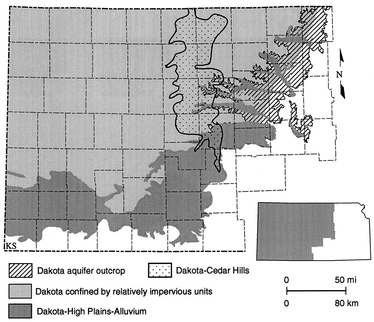
Table 1—Stratigraphy and hydrostratigraphy of the shallow subsurface in the vertical profile from southeastern Colorado to western and central Kansas.
| Era | System | Rock Stratigraphic Units |
Hydrostratigraphic Units |
|---|---|---|---|
| Cenozoic | Quaternary | Unconsolidated Sediments | High Plains & Alluvial Valley aquifers |
| Tertiary | Ogallala Fm. | ||
| Mesozoic | Cretaceous | Colorado Group | Upper Cretaceous aquitard |
| Dakota Ss./Dakota Fm. | Upper Dakota aquifer | ||
| Purgatoire Fm/Kiowa Fm. | Kiowa Shale aquitard | ||
| Lower Dakota aquifer | |||
| Jurassic/Triassic | Morrison Fm. Dockum Group |
Morrison-Dockum aquifer1 | |
| Paleozoic | Permian/ Pennsylvanian |
Permian Undiff. | Permian-Pennsylvanian aquitard |
| Cedar Hills ss. | Cedar Hills Sandstone aquifer | ||
| Permian/Pennsylvanian Undiff. |
Permian-Pennsylvanian aquitard |
||
| 1. The Morrison-Dockum is considered an aquifer only in southeastern Colorado and adjacent southwestern Kansas. Elsewhere in Kansas it is included in the Permian-Pennsylvanian aquitard. |
|||
Westward dipping Jurassic and Permian rocks directly underlie the Dakota aquifer in Kansas (Hamilton, 1994). The subcrop of the Jurassic Morrison Formation beneath the Cretaceous is generally in the western part of the state, whereas the Permian subcrop is in the central part (Figure 2). In southwestern Kansas the Morrison consists mostly of sandstone and is a source of fresh water along with the Cheyenne Sandstone. Upper and lower Permian rocks consist of shale, siltstone, sandstone, and bedded salt with minor amounts of limestone and dolomite. Outside of southwestern Kansas, the Morrison, and the Permian and Pennsylvanian sequences form a thick regional aquitard. However, sandwiched within this aquitard is the Cedar Hills Sandstone aquifer which subcrops beneath the lower Dakota aquifer in central Kansas (Table 1, Figure 3). The Cedar Hills Sandstone aquifer consists of the Permian Cedar Hills Sandstone and the sandstones and shaly sandstones at the top of the underlying Salt Plain Formation.
Hamilton, V.J., 1994, Sequence stratigraphy of Cretaceous Albian and Cenomanian strata in Kansas, in Shurr, G. W., Ludvigsen, G. A., and Hammond, R. H., eds., Perspectives on the Eastern Margin of the Cretaceous Western Interior Basin: Geological Society of America Special Paper 287, p. 79-96.
Hattin, D.E., 1962, Stratigraphy of the Carlile Shale (Upper Cretaceous) in Kansas: Kansas Geological Survey Bulletin 156, 155 p. [available online]
Hattin, D.E., 1965, The stratigraphy of the Graneros Shale (Upper Cretaceous) in central Kansas: Kansas Geological Survey Bulletin 178, 83 p. [available online]
Hattin, D.E., 1975, Stratigraphy and depositional environment of Greenhorn Limestone (Upper Cretaceous) of Kansas: Kansas Geological Survey Bulletin 209, 128 p. [available online]
Hattin, D.E., 1982, Stratigraphy and depositional environment of Smoky Hill Chalk Member, Niobrara Chalk (Upper Cretaceous) of the type area, western Kansas: Kansas Geological Survey, Bulletin 225, 108 p. [available online]
Hattin, D.E., and Siemers, C.T., 1987, Guidebook Upper Cretaceous stratigraphy and depositional environments of western Kansas (with modifications): Kansas Geological Survey Guidebook Series 3, 55 p. [available online]
Macfarlane, P.A., 1995, The effect of river valleys and the upper Cretaceous aquitard on regional flow in the Dakota aquifer in the central Great Plains of Kansas and southeastern Colorado: Kansas Geological Survey Bulletin 238, pp. 11-30. [available online]
Previous Page--Definitions ||
Next Page--Hydrostratigraphy
Dakota Home ||
Start of Report
Kansas Geological Survey, Dakota Aquifer Program
Updated April 8, 1996.
Scientific comments to P. Allen Macfarlane
Web comments to webadmin@kgs.ku.edu
The URL for this page is HTTP://www.kgs.ku.edu/Dakota/vol1/hydro/hydro03.htm