The Dakota Formation, of Russell and Ellsworth counties in central Kansas, are targeted in this study. Emphasis is placed on the Rocktown Channel Sandstone and the basal sandstone of the Terra Cotta Clay Member. Field work for this first Summer focused on characterization of type, size, shape, and spatial distribution of the geometric building blocks that constitute these Dakota strata.
Twenty-seven outcrop localities of Rocktown Channel Sandstone near the Saline River and Wilson Lake (in Russell County) and two exposures of the Terra Cotta basal sandstone near Kanapolis Lake (in Ellsworth County) were studied in the Summer of 1995 (see Appendix A). Photopanoramic cross sections were developed for each outcrop location (see Appendix B), and were then used to define alluvial elements of Rocktown Channel Sandstone and basal Terra Cotta sandstone strata using techniques of Miall (1985).
Elements defined at each location were then assessed as to their shape, dimensions, lithofacies fill, frequency of occurrence, spatial relationship with other elements, and paleocurrent trends. Element shape, dimensions, and relationship with other elements was assessed directly off the photos. About half of these elements are not fully exposed, and their missing portion implied from comparisons with similar elements. Frequency of occurrence for each element was determined by measuring the percent of outcrop area occupied by each element in its respective photopan. An average frequency of occurrence was obtained for each element by comparing the total area of exposure occupied by each element to the total area of outcrop observed (Table 1). Future frequency estimates for elements will augment these outcrop data with well-log information. Paleocurrent data were measured from planar and trough cross-bedding to determine paleoflow orientations to assess preferred orientation of architectural elements. Appendix C shows paleocurrent data and the method used to calculate the average paleocurrent direction (see Appendix C for a sample calculation of paleocurrent average).
Table 1--Frequency of occurrence for each element by measureing percent of outcrop area occupied by each element in its respective photopan.
| Location | Channel fill element percent |
Channel fill element percent (mud) |
Overbank fine element percent |
Foreset macroform element percent |
Sandy bedform element percent |
Lateral accretion element percent |
|---|---|---|---|---|---|---|
| 1d | 30 | 5 | 60 | 5 | ||
| 2d | 40 | 30 | 20 | 10 | ||
| S1 | 20 | 10 | 70 | |||
| S2 | 100 | |||||
| S3 | 100 | |||||
| S4 | 100 | |||||
| S5 | 30 | 65 | 5 | |||
| S6 | 40 | 60 | ||||
| S7 | 70 | 10 | 5 | 15 | ||
| S8 | 100 | |||||
| S9 | 20 | 70 | 10 | |||
| S10 | 70 | 30 | ||||
| S12 | 100 | |||||
| S13 | 100 | |||||
| S14 | 30 | 70 | ||||
| S15 | 50 | 10 | 40 | |||
| W1 | 100 | |||||
| W2 | 100 | |||||
| W3 | 100 | |||||
| W4 | 90 | 10 | ||||
| W5 | 80 | 20 | ||||
| W6 | 100 | |||||
| W7 | 100 | |||||
| W8 | 100 | |||||
| W | 80 | 20 | ||||
| Average percent | 30 | 5 | 45 | 5 | 5 | 10 |
Lab Methods--Mathematical Modeling
After collecting field data, it must be entered into the computer. This presents difficulties: First, in what format should the data appear; Second, after the data is input, what mathematical techniques will allow the model to determine the subsurface geology? Each architectural element is characterized by the element type and six field measurements/calculations. (see the previous section on Field Methods), effectively giving us a function of seven variables. The chaotic nature of aquifer deposition lends itself to a stochastic, or probabilistic, model. In these models, the data is entered as discrete elements into a lattice on the computer. Each element type is identified by an element number, m. Also, each data point has a unique location on the lattice (a lattice node (i, j), and at that node the program stores all the information about that particular element.
The stochastic model is generated one lattice consisting of squares. To do this, a rectangular grid system is superimposed over the domain of interest as shown below:
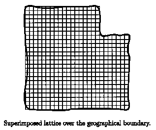
The actual shape of the basin is approximated by a system of straight lines to facilitate the computations. This grid point approximation of the basin comprises of a specific number of rows (j), column, (i) and a total number of lattice nodes (n). The model assigns an architectural element at each node (i, j). The horizontal and vertical resolutions (Dx and Dy) are chosen using the field size, and the needed resolution, while considering run time. The size of the element determines which nodes are occupied (for that element; as the model is generated, all of the grid nodes are filled). At this point the model consists solely of empty (i.e. unknown) lattice nodes. Creating the model now involves two steps: initiation and generation.
Previous Page--Stratigraphic and Depositional Setting ||
Next Page--Initialization
Dakota Home ||
Start of the Stochastic Modeling Report