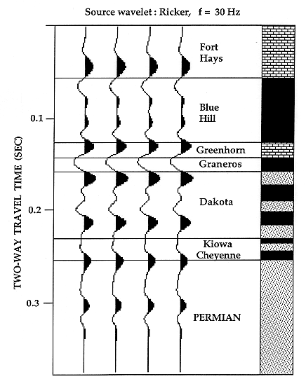
Seismic energy sources used by the energy industry are required to generate reflections from rock units several thousand feet below the surface, and so typically have frequencies of the order of 30 Hz. A simulation of a field record of this type is shown in Figure 1. This synthetic seismogram was computed using a sonic log recorded in a Dakota Aquifer program observation well in Ellis County. Notice that the depth scale is not measured in feet but in units of two-way travel time in seconds that record the time that elapsed between the triggering of the energy source and the arrival of the reflection at the geophone. Because the sound velocity changes continuously with depth the time record is not a simple transformation of depth. The reflection peaks (black) pick up rock boundaries where the acoustic velocity increased downwards going from a "slow" shale to a "faster" limestone or sandstone, while the reflection troughs (white) match the reverse situation. The 30 Hz frequency of the energy source results in a fairly coarse resolution, so that only fairly thick rock units with strong impedance contrasts can be distinguished. This characteristic can be seen in Figure 1, where the stratigraphic units are resolved easily, but reflections generated by the sandstones within the Dakota Aquifer tend to overlap and merge.
Figure 1. Synthetic seismogram for the Dakota aquifer and adjacent stratigraphic units, calculated from geophysical logs in the observation well KGS Braun #1 (NENENE 30-12S-18W), Ellis County, Kansas.
Better precision can be obtained by high-frequency seismic shooting of Dakota Aquifer sections where they are fairly close to the surface. Coyle (1990) made several field studies in the vicinity of Dakota Aquifer program observation wells to evaluate the feasibility of seismic methods in the location of channel sandstones. Sonic logs at the wells could be used to create synthetic seismograms, so that interpretations of field records could be correlated with geology.
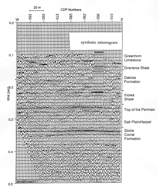
Gamma-ray and sonic logs are shown from a second observation well in Ellis County (Figure 2). The sonic log was converted to a two-way reflection time record of velocity, which was then transformed to a train of reflection coefficients and convolved with a 100 Hz Ricker wavelet (Figure 3). By superimposing the synthetic seismogram at the observation well location on the East-West seismic line (Figure 4), the field reflections can be related to specific geological features. The Stone Corral provides a strong reflector that is easily recognized on seismic records from the entire region The contact between the Dakota Formation and the underlying Kiowa Shale can be seen , and is caused by the sharp change in velocity at the contact (see Figure 2). Reflections from the Greenhorn Limestone, Graneros Shale, and the top of the Dakota Formation can also be identified on the field record from their signatures on the synthetic seismogram. The distinctive and laterally continuous reflection at 0.26 seconds was interpreted to coincide with the top of the Permian.
Figure 2. Gamma-ray and sonic logs from observation well KGS Brungardt #1 (SESESE 25-12S-17W), Ellis Co., Kansas.
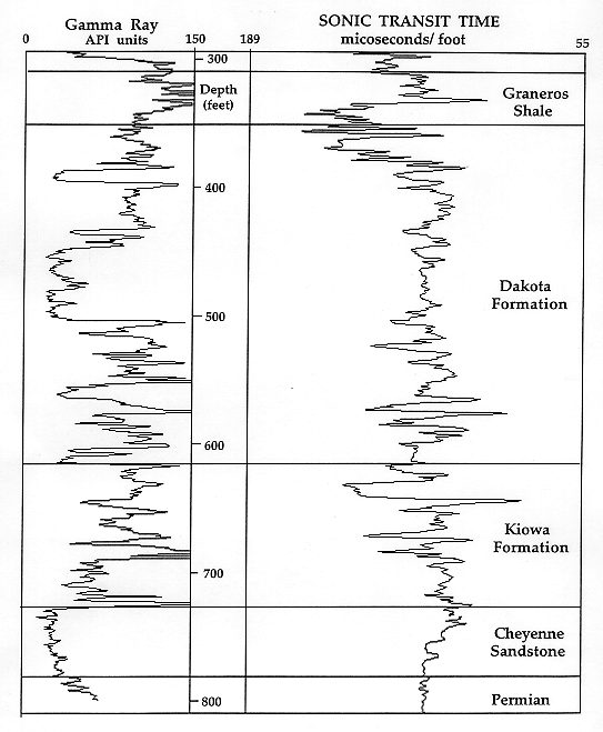
Figure 3. Computation of synthetic seismogram from the sonic log of the Brungardt well (see Figure 2) by the conversion from depth to a scale of acoustic travel time and convolution with a Ricker wavelet of frequency 100 Hz (from Coyle, 1990).
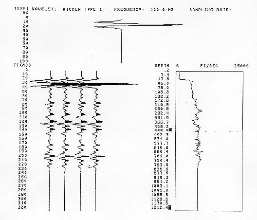
Figure 4. Comparison between the synthetic seismogram computed from the Brungardt well sonic log (see Figure 3) and a field seismic line shot at the well site (from Coyle, 1990).
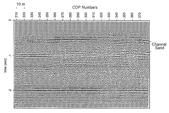
Coyle (1990) concluded that while thin sandstone lenses within the Dakota would not be detectable at this frequency (100 Hz), modeling suggested that sandstones thicker than 30 feet would be resolvable. A field seismic line shot over a Dakota channel sandstone at another site gave some support to his conclusion (Figure 5). Thinner sandstones could be identified where reflections were recorded with frequencies higher than 180 Hz. The resolution and quality of seismic records were also found to be site dependent. The best sites were located on fresh exposures of Graneros Shale, where reflections of 200 Hz and higher were recorded. The worst sites occurred on the Greenhorn Limestone outcrop, while low frequencies were recorded at levels higher than the Greenhorn.
Figure 5. CDP seismoc section tied to Dakota Aquifer program observation well KGS Haberer #1 (NESENE 14-12S-15W), Russell County, Kansas. Note channel sandstone. From Coyle, 1990.
Reference:
Coyle, W.G., III, 1990, Feasibility of detecting sandstone lenses in the Dakota Formation by seismic reflection, Russell and Ellis Counties, Kansas: Unpubl. MS thesis, Univ. Kansas, 59 pp.