Hodgeman County Study, part 2 of 12
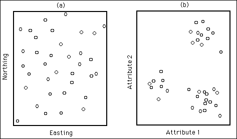
Classification of specimens into groups is one of these simplifying models. In our context we will be dealing with sites instead of specimens or objects. In a regionalized classification the sampling domain is a multidimensional geographic space, usually a portion of planet Earth with dimension three. If one surveys a coregionalization by making several measurements per site, the survey defines another multidimensional space, a space with as many dimensions as the attributes considered in the sampling, commonly four or larger. In such a space one can depict each site as a point whose coordinates are the value of the attributes at such site. The assumption of regionalized classification is that the points in the attribute space are not uniformly and regularly distributed. Instead, as illustrated i n Figure 1, there are zones with few or no points at all and other places with high concentrations of points. Notice that it is not possible to model such a relationship through regression.
Figure 1. Idealized coregionalized sampling: (a) location of sampling sites in a two-dimensional space in a survey comprising measurement of two attributes per site; (b) mapping of the observations in the attribute space showing three clusters.

The aim of regionalized classification is to explore the assumption that observations form distinct clusters in atribute space and to take advantage of it in case one finds grounds to support it. If that is the case, regionalized classification breaks the observations into groups that are as internally homogeneous as possible and as different as possible among them. Proximity in attribute space does not guarantee proximity in geographical space, yet in practice one finds that observations in the same attribute space cluster tend to stay close in the geographical space in various degrees. If one assigns contrasting colors to each group, the resulting group map in the geographic space resembles a geologic map, which is a type of regionalized classification map.
Another way to view regionalized classification is as a tool to condense maps. One can map all attributes of a coregionalization separately and inspect them to find relationships among features in the different maps. The task is simplified by the use of a light table, but becomes progressively difficult as the number of attributes in the survey increases. Regionalized classification is a convenient replacement of the light table to produce a single objective and accurate summary map, regardless of the number of attributes.
Conceptually nothing is new in regionalized classification. What is novel is the joint application of several standard techniques. Harff and Davis (1990) published the first complete formulation of the method combining geostatistical elements with some inspirational ideas of soviet geologists (Voronin, 1967; Rodionov, 1981; Kogan, 1986).
Introduction ||
Next Page--Typification
Dakota Home ||
Start of Hodgeman County Study