


|


|
Region: Northern Midcontinent
System: Pennsylvanian
Lower Desmoinesian--Summary
This Lower Desmoinesian Play information is from the
U. S. Geological Survey
1995 National Assessment of United States Oil and Gas Resources (available
on CD-ROM from the U.S.G.S. as Digital Data Series DDS-30, Release 2).
|
Lower Desmoinesian Stratigraphic Gas and Oil Play
by Mitchell E. Henry and Timothy C. Hester
Desmoinesian, Missourian, and Virgilian strata were deposited in
transgressive-regressive cycles that periodically inundated the Anadarko
Basin area with marine environments. These depositional cycles are
reflected in alternating sandstone and limestone lithologies
(interbedded with shale) that can be separated into stratigraphic
packages of mostly sandstone or mostly limestone reservoirs (Moore,
1979; Rascoe and Adler, 1983). Each epoch consists of 1
sandstone-limestone cycle, which we have then subdivided into 2 plays, a
mostly-sandstone play (lower part) and a mostly limestone play (upper
part). Because the upper boundaries of the limestone plays coincide
with epoch boundaries, stratigraphic correlations are relatively
straightforward and universally understandable (for example, top of the
Desmoinesian, top of the Missourian, and so forth). However, within
epochs, chronostratigraphic and nomenclatural inconsistencies greatly
complicate a precise definition of the play boundaries. Nevertheless, a
rough description of these somewhat conceptual boundaries are given for
each play.
The Lower Desmoinesian Stratigraphic Gas and Oil Play contains mostly
sandstone reservoirs, and consists of all strata of the Middle
Pennsylvanian Cherokee Group and those correlative strata in the lower
part of the Middle Pennsylvanian Deese Group. The upper boundary of
this play is the top of the Lower Desmoinesian Cherokee Group, which is
represented in most areas by the Prue sand or its correlatives. This
play extends throughout the province, except that part near the southern
boundary where Lower Desmoinesian strata are absent, parts of eastern
Colorado, and that part included in Deep Stratigraphic Gas Play.
Depths to the top of the Prue sand (the uppermost unit of the Cherokee
Group) range from 3,500 ft on the northern shelf to about 12,000 ft near
the Wichita Mountains front. Almost all major reservoirs assigned to
this play are sandstone, but limestone reservoirs do exist. The
predominance of sandstone reservoirs is the principal defining feature
of this play.
Reservoirs
Reservoirs consist of all Lower Desmoinesian sandstones and limestones,
including the Burgess, Bartlesville, Red Fork, Skinner, Prue, Osborne,
Pooler, Hart, and Charleston sands. Rocks in this play generally
thicken to the south, reaching an estimated 1,500 ft along the Wichita
Mountains front. The Red Fork sands in north-central Oklahoma, which
were deposited as stream channels and offshore sand bars (Withrow,
1968), are probably typical of other Lower Desmoinesian sands as well.
The relative proportions of sandstone and shale in the Red Fork sand
vary in the play from mostly sand in the northeastern part of the
province (Withrow, 1968) to mostly shale in the deeper-water facies
(Whiting, 1984). Porosity of these rocks ranges from 12 to 15 percent.
Farther south and west, toward the deep Anadarko Basin, Red Fork sands
developed as the result of channelized density transport (Whiting,
1984). Porosity of these deeper sands range from 1 to 17 percent, with
an average of about 8 percent. Permeabilities in all areas are often
low, averaging about 0.1 mD (Whiting,1984). Reservoir quality in both
areas is expected to be variable (Withrow, 1968; Whiting, 1984; Levine,
1984).
Source rocks
Middle and Upper Pennsylvanian black shales overall have good genetic
potential (Burruss and Hatch, 1989). TOC, which ranges from 0 to 18
percent, is from a mixture of types II and III kerogens. Burial
histories (Schmoker, 1989) indicate most of the Oklahoma and Texas parts
of this play are thermally mature with respect to oil generation; the
Kansas and Colorado parts are not. Major accumulations located in
thermally mature areas are probably sourced by the surrounding shales.
In the immature areas of Kansas, petroleum migration from Woodford Shale
or Ordovician shales may have occurred. Some immature areas in Colorado
may even have been sourced from the Denver basin (Burruss and Hatch,
1992).
Timing and migration
Modeling by Schmoker (1989) suggests that potential source rocks of the
Cherokee Group may have entered the thermal zone of oil generation at
about 250 Ma. Favorable timing of trap development and hydrocarbon
generation and migration is evidenced by the presence of numerous major
accumulations in this play.
Traps
Reservoir trap types are mostly stratigraphic (Bingham, 1993), with a
few influenced by structure. Traps probably formed as shales were
deposited over porous channel-filling subaerial or submarine sands, or
over offshore bars; seals are probably formed by enclosing shales
(Withrow, 1968).
Exploration status
This play is well explored, with more than 37,000 reported wells
although the actual total probably exceeds 53,000. The play is most
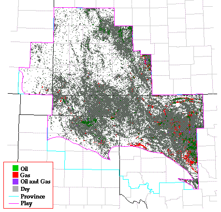
densely drilled in Oklahoma and Texas. Seventy-nine major accumulations
are assigned to this play, 24 oil and 55 gas. The largest oil
accumulation is at Cherokita Trend, with an estimated ultimate recovery
of 30 MMBO. The largest gas accumulation is at North Moorwood field,
with an estimated ultimate recovery of 1.5 TCFG.
Resource potential
In spite of being well explored and already producing from a large
number of major accumulations, this play is expected to contain
significant undiscovered resources. The parts of this play in Kansas
and Colorado, however, show low thermal maturity levels, have poorer
reservoir quality and overall fewer sands than the parts of the play in
Oklahoma and Texas and are therefore not projected to have as much
resource potential. Historical data on major discoveries, individual
well completions, and thermal maturity were used extensively in
assessing this play.
Play Map
References
Burruss, R.C., and Hatch, J.R., 1989, Geochemistry of oils and
hydrocarbon source rocks, greater Anadarko basin--evidence for multiple
sources of oils and long-distance oil migration, in Johnson,
K.S., ed., Anadarko Basin Symposium, 1988: Oklahoma Geological Survey
Circular 90, p. 53-64.
Burruss, R.C., and Hatch, J.R., 1992, Geochemistry of Pennsylvanian
crude oils and source rocks in the greater Anadarko basin--Oklahoma,
Texas, Kansas, Colorado, and Nebraska: An update [abs.], in
Johnson, K.S., and Cardott, B.J., eds., Source rocks in the southern
Midcontinent, 1990 Symposium: Oklahoma Geological Survey Circular 93,
p. 197.
Lavine, S.A., 1984, Provenance and diagenesis of the Cherokee
sandstones, deep Anadarko basin, western Oklahoma: Shale Shaker, v. 34,
p. 120-144.
Moore, G.E., 1979, Pennsylvanian paleogeography of the southern
Midcontinent, in Hyne, N.J., ed., Pennsylvanian sandstones of the
mid-continent: Tulsa Geological Society Special Publication no. 1, p.
2-12.
Rascoe, Bailey, Jr., and Adler, F.J., 1983, Permo-Carboniferous
hydrocarbon accumulations, Mid-Continent, U.S.A.: American Association
of Petroleum Geologists Bulletin, v.67, no. 6, p. 979-1001.
Schmoker, J.W., 1989, Thermal maturity of the Anadarko basin, in
Johnson, K.S., ed., Anadarko Basin Symposium, 1988: Oklahoma Geological
Survey Circular 90, p. 25-31.
Whiting, P.H., 1984, Depositional environment of Redfork sandstones,
deep Anadarko basin, western Oklahoma: Shale Shaker Digest 11, p.
120-144.
Withrow, P.C., 1968, Depositional environments of Pennsylvanian Red Fork
Sandstone in northeastern Anadarko basin, Oklahoma: American
Association of Petroleum Geologists Bulletin, v. 52, no. 9, p.
1638-1654.
Kansas Geological Survey, Digital Petroleum Atlas
Updated July 17, 1996
Comments to webadmin@kgs.ku.edu
URL=http://www.kgs.ku.edu/DPA/frontEnd/Anadarko/LoDesmo/provSum.html