Major DPA Pages
As the DPA began, we were faced primarily with gathering data at the field and well scale and placing this data online. As a home page, we created an interactive map of Kansas linked to all the counties in the state (Figure 1). The Kansas DPA Home Page provides numerous paths to access Kansas petroleum information and technology at the various geographic scales and topical areas. Access is provided to reviews of the regional geological setting, overviews of oil and gas plays and to information and technology at the county, field and well levels.
A regional geological setting page provides access to statewide gravity and magnetic maps to a map of the oil and gas provinces in Kansas and to other regional maps. The gravity and magnetic maps were constructed using data maintained by the Kansas Geological Survey. The gravity and magnetic maps are available to the user on-line at a statewide and county scale. A number of overlays including oil and gas field outlines are available. The geologic province map of Kansas displays the main oil and gas provinces of Kansas. The oil and gas provinces are displayed as defined by the Kansas Geological Survey and the US Geological Survey (1995). The geologic province map functions as a graphical user interface to provide access to more detailed geologic and petroleum information for each geologic province.
As an alternative to finding information by clicking on interactive maps, the user can access various searches for particular wells or fields. The user can search for wells by API. This search allows the user to access the DPA databases to find wells by entering an API number (county and 5-digit well number). The user can search for wells by Township-Range. By entering a township and range pair, the user can find all wells in a certain area. Adding section information can narrow the search. The user can search for fields by name. Fields added to the DPA or in the main Kansas Geological Survey oil and gas databases can be found by entering all or part of the field name. Finally the user can search for oil and gas fields by entering general field parameters. By entering general field information (e.g., minimum cumulative oil produced, field discovery date), the DPA will show all fields that match the desired values.
Using the interactive state map the user selects a county of interest. If a county contains fields in the DPA, the visitor is linked to Atlas pages covering the county (Figure 7). These county pages contained geologic, geophysical and production information at the county level. The county map is also interactive and contains links to the field studies that are currently part of the DPA. For counties that do not contain fields in the DPA, the visitor is taken to county maps showing field outlines and oil and gas production at the county and field levels (Figure 8). Each field study that is included in the DPA has a field page containing links to topical areas (Figure 9).
As part of second year of the DPA project, studies were undertaken at three Kansas fields and producing areas. These were added to the previously existing field studies. The three additions are:
- Terry Field (Producing Formations: Kansas City Group--multiple zones, Marmaton Group--multiple zones, Pleasanton, Morrow, and Mississippian) in Finney County;
- Amazon Ditch (Producing Formations: Kansas City Group--multiple zones, Marmaton Group--multiple zones, and Mississippian) in Finney County;
- Regional Kansas City Group fields in Lane County.
New data and research products are added to each field study, as they become available. Publication in the DPA is an ongoing process that continuously updates the data and technology associated with each field study. Each field study homepage provides a map of the field area, basic field and discovery information, and a standardized set of links to additional geologic, geophysical, engineering and production data.
For each county and field page in the DPA a paper mockup of a standard set of field pages was created on a bulletin board. The paper mockup allowed for flexible thinking in terms of button layouts, numbers of buttons, and basic navigation issues. Based on trial and error a basic page style evolved.
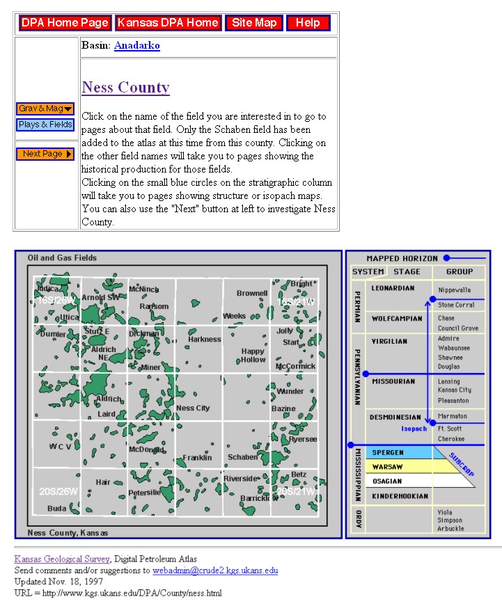
Figure 7.—Sample county page from the Digital Petroleum Atlas that contains a field study showing navigation buttons and page layout. Map and stratigraphic column are interactive and linked to other county scale and field pages.
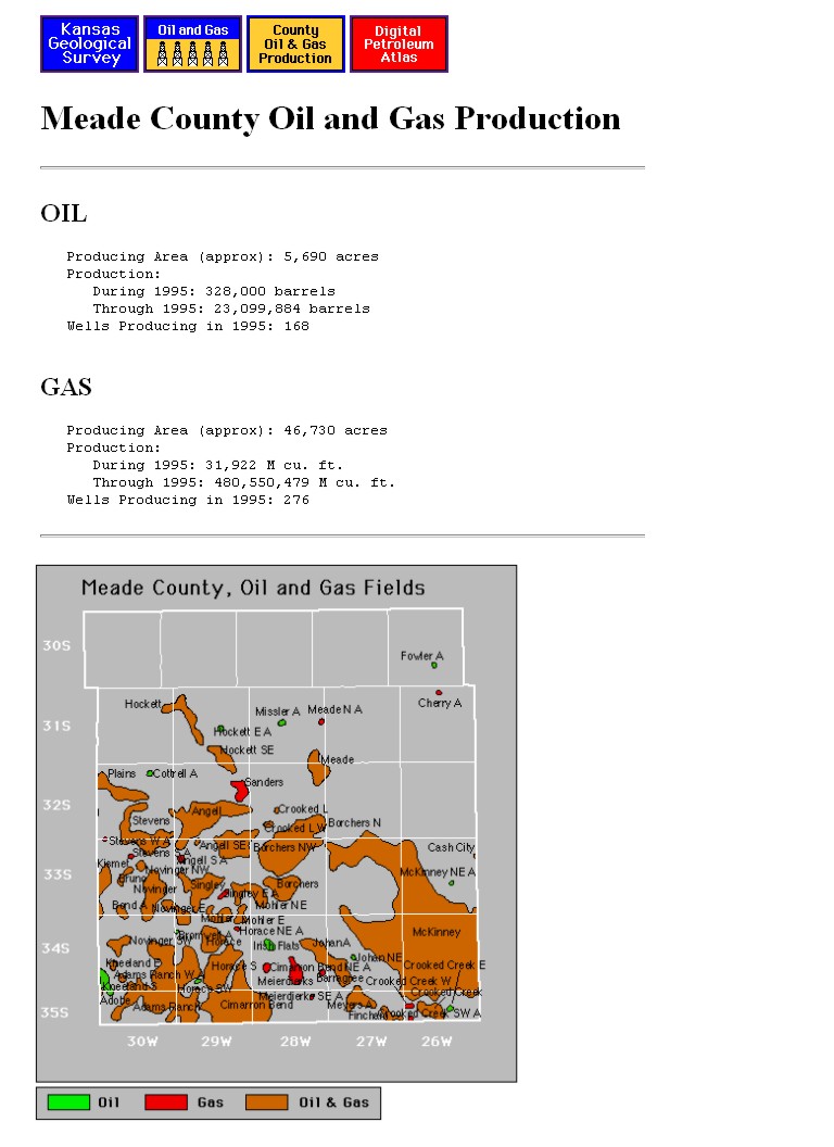
Figure 8.— Sample county page from the Digital Petroleum Atlas that does not contain a field study showing navigation buttons and page layout. Map shows outlines of oil and gas fields and contains links to production data for all fields in the county.
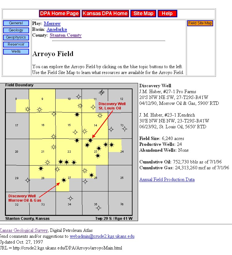
Figure 9.--Sample field page from the Digital Petroleum Atlas showing navigation buttons and page layout. Map shows outline field and contains links to topical data, maps, cross-sections and technical discussions.
| Previous Page | Web Structure | Next Page | Navigation Style |