    |
Preparation of Northern Mid-Continent Petroleum Atlas
Reporting Period: July 1, 1998 - September 30, 1998
|
|
Cooperative Agreement No.: DE-FG22-97BC15008 |
|
Contractor Name and Address: The University of Kansas Center
for Research Inc. |
|
Date of Report: June 1, 2000 |
|
Award Date: August 12, 1997 |
|
Government Award for Current Fiscal Year: $ 250,000 |
|
Principal Investigators |
|
|
Lee C Gerhard (Principal Investigator |
|
|
Timothy R. Carr (Program Manager) |
|
|
W. Lynn Watney |
|
|
Project Manager: Chandra Nautiyal, NPTO, Tulsa |
Objectives
As proposed, the third year program will continue and expand
upon the Kansas elements of the original program, and provide
improved on-line access to the prototype atlas. The third year
of the program will result in a digital atlas sufficient to provide
a permanent improvement in data access to Kansas operators. The
ultimate goal of providing an interactive history-matching interface
with a regional database will be demonstrated as the program covers
more geographic territory and the database expands. The atlas
will expand to include significant reservoirs representing the
major plays in Kansas, and North Dakota.
Primary products of the third year prototype atlas will be
on-line accessible digital databases and technical publications
covering two additional petroleum plays in Kansas and one in North
Dakota. Regional databases will be supplemented with geological
field studies of selected fields in each play. Digital imagery,
digital mapping, relational data queries, and geographical information
systems will be integral to the field studies and regional data
sets. Data sets will have relational links to provide opportunity
for history-matching, feasibility, and risk analysis tests on
contemplated exploration and development projects. The flexible
"web-like" design of the atlas provides ready access
to data, and technology at a variety of scales from regional,
to field, to lease, and finally to the individual well bore. The
digital structure of the atlas permits the operator to access
comprehensive reservoir data and customize the interpretative
products (e.g., maps and cross-sections) to their needs. The atlas
will be accessible in digital form on-line using a World-Wide-Web
browser as the graphical user interface.
Regional data sets and field studies will be freestanding entities
that will be made available on-line through the Internet to users
as they are completed. Technology transfer activities will be
ongoing from the earliest part of this project, providing data
information sets to operators prior to the full digital atlas
compilation.
Summary of Technical Progress
As a continuation of the first two years of the project "Pages"
and data schema for the atlas overview and field studies were
enhanced and made accessible through the world-wide-web. The atlas
structure includes access to geologic, geophysical and production
information at levels from the national, to the regional, to the
field to the individual well. Several approaches have been developed
that provide efficient and flexible screening and search procedures.
Database queries are now routed through a improved database design
that provides the individual access to production, well-log, core
and other databases. The continually evolving digital atlas is
accessible through the Kansas Geological Survey Petroleum Research
Section (PRS) HomePage (The Universal Resource Locator [URL] is
http://www.kgs.ku.edu/PRS/PRS.html
). The Digital Petroleum Atlas (DPA) HomePage is available
directly at http://www.kgs.ku.edu/DPA/dpaHome.html.
Technology transfer is underway through presentations at national
and regional meetings and through the use of monthly electronic
updates and the on-line availability of the DPA products. Project
information and Quarterly Progress Reports are linked to the Digital
Petroleum Atlas HomePage. This quarterly report will focus on
the additions to the number of reservoirs incorporated into the
atlas structure.
Additions to Atlas Content
As the DPA began, the primary task was gathering data at the
field and well scale and placing this data online. As a home page,
we created an interactive map of Kansas linked to all the counties
in the state (Figure 1). The Kansas DPA Home Page remains the
primary portal, and provides numerous paths to access Kansas petroleum
information and technology at the various geographic scales and
topical areas. Access is provided to reviews of the regional geological
setting, overviews of oil and gas plays and to information and
technology at the county, field and well levels. The total number
of static web pages exceeds 6,000, but this is a decrease from
previous years. Pages constructed using programs that access relational
databases are replacing static web pages.
The DPA provides access to a number of regional maps, studies
and data sets (e.g., gravity and magnetics, and discussions of
Kansas oil and gas provinces). In year 3, the major addition to
regional maps was an extensive linked set of statewide structure
and isopach maps with overlays of oil and gas production (Figure
2). These regional maps permit the user to toggle among a number
of maps covering all major oil and gas producing intervals. The
user can also select map type (i.e., structure or isopach), and
type of production overlay (i.e., oil or gas).
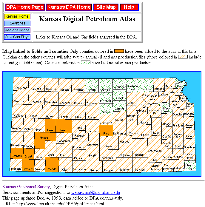
Figure 1. Interactive map of Kansas Digital Petroleum
Atlas (DPA) showing counties that contain fields and plays that
have been added to the DPA. Regional maps on key horizons are
available for all highlighted counties. Counties not added to
the DPA have oil and gas field maps and links to annual field
production. During year three, county-scale maps were added covering
Meade and Rice counties, and access to current production and
well data was automated.
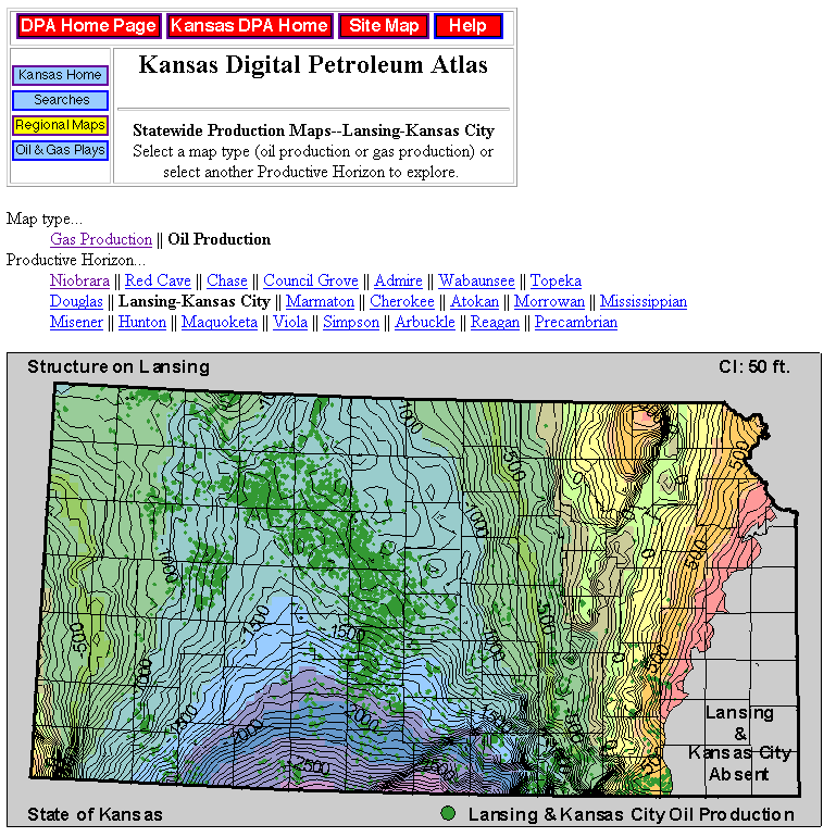
Figure 2. Regional structure map on the top of the Lansing
Group showing the distribution of all leases in Kansas that reported
oil production from Lansing and Kansas City groups. Similar structure
and isopach maps with overlays of oil and gas production are available
for all major-producing intervals (http://www.kgs.ku.edu/DPA/Plays/ProdMaps/lgkc_oil.html).
As part of third year of the DPA project, studies were undertaken
at two Kansas fields and producing areas. These were added to
the previously existing field studies. The two additions are:
• McKinney Field (Producing Formations: Kansas City Group--multiple
zones, Marmaton Group--multiple zones, Pleasanton, Morrow, and
Mississippian) in Meade County (figures 2, 4, 5);
• Chase-Silica Field (Producing Formations: Kansas City
Group--multiple zones, Marmaton Group--multiple zones, and Mississippian)
in Rice, Barton and Stafford county (Figure 3).
The Chase-Silica Field is notable because of its geographic
extent (eight townships), number of wells (> 10,000) and development
of new methodologies to reduce the number of static web pages.
The McKinney Field provided the first application of "zoom"
and "pan" to access and navigate detailed geologic and
field maps (Figure 5).
New data and research products continue to be added to each
field study, as they become available. Publication in the DPA
is an ongoing process that continuously updates the data and technology
associated with each field study. The addition of the ability
to query relational databases increased the efficiency of updating
previously completed field studies. Each field study homepage
provides a map of the field area, basic field and discovery information,
and a standardized set of links to additional geologic, geophysical,
engineering and production data.
For each county and field page in the DPA a paper mockup of
a standard set of field pages was created on a bulletin board.
The paper mockup allowed for flexible thinking in terms of button
layouts, numbers of buttons, and basic navigation issues. Based
on trial and error a basic page style evolved and appears to be
stable.
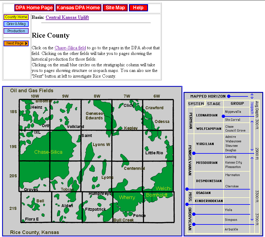
Figure 3. Sample county page from the Digital Petroleum
Atlas that contains a field study showing navigation buttons and
page layout. Map and stratigraphic column are interactive and
linked to other county scale and field pages.
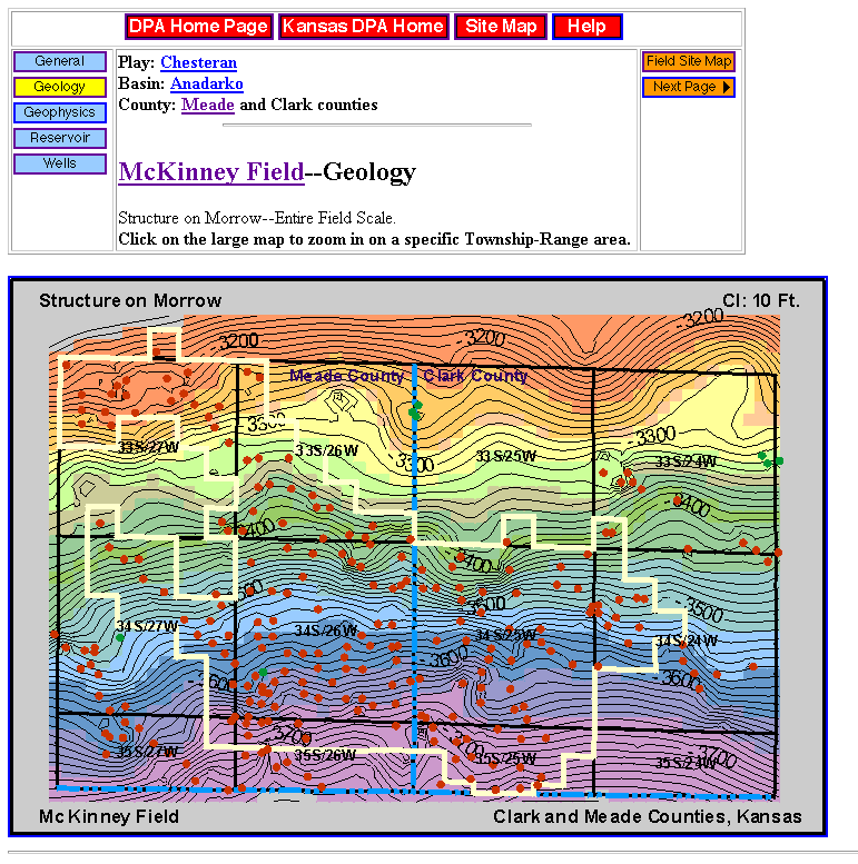
Figure 4. Sample field page covering McKinney Field,
Meade County from the Digital Petroleum Atlas. Map shows navigation
buttons, page layout, field outline. The field page contains links
to topical data, maps, cross-sections and technical discussions.
Clicking on a selected township provides a detailed geologic map
(Figure 5). Not shown is stratigraphic column that controls selection
of horizon for structure or isopach map.
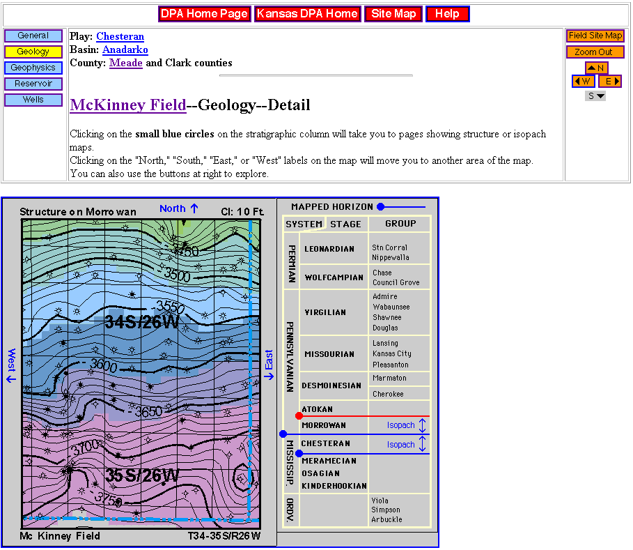
Figure 5. Sample of detailed geologic map covering a
portion of McKinney Field, Meade County. Page shows navigation
buttons, panning controls to move map location and selection of
stratigraphic horizons. Map contains links to topical data, maps,
cross-sections and technical discussions.
Technology Transfer
The world-wide-web and publish as-you-go design of the Digital
Petroleum Atlas Project provides immediate and ongoing technology
transfer activities. Based on increased usage statistics and informal
industry feedback, the DPA model appears to provide an efficient
method of technology transfer to the geographically dispersed
high technology petroleum industry (Figure 6). The pages that
comprise the DPA are among the most visited on the Kansas Geological
Survey web site and usage continues to grow (Figure 6). Periodic
email updates provided to interested operators and individuals
have been well received. The Digital Petroleum Atlas Project has
been integrated into the Internet for the Petroleum Professional
Course. This is a popular course for oil and gas producers and
is taught as part of the North Midcontinent part of Petroleum
Technology Transfer Council (For example see online version of
the Internet course at http://www.kgs.ku.edu/General/Tutorial/Internet/findex.html).
Table 1. Presentations undertaken from 1 July through
30 September as part of third year of the Digital Petroleum Atlas
Project.
• Two Workshops on Kansas Online Resources at Kansas
Independent Oil and Gas Association (KIOGA), Wichita, Kansas,
August 1998
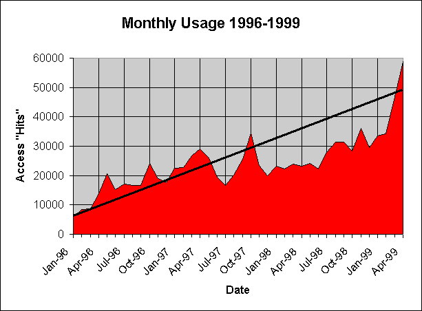
Figure 6. Monthly usage statistics measure separate
pages viewed from the Petroleum Research server. Miscellaneous
graphics and access from Kansas Geological Survey computers are
removed prior to analysis. Current usage statistics are collected
daily and are available on the Petroleum Research Section of the
Kansas Geological Survey web site (http://www.kgs.ku.edu/usage/past_stats.html).
Updated June 2000
Comments to webadmin@kgs.ku.edu
URL=http://www.kgs.ku.edu/DPA/Reports/dpa98-4.html