Demonstration of the Use of Cost-effective Tools to
Analyze Core, Log, and Production Data to Develop a Reservoir
Model for Minneola Field, Clark County, Kansas, and to Evaluate
its Performance under Waterflood.
KGS Open-File Report 99-34
Cooperative Agreement No.: C73590016-35
by Saibal Bhattacharya, Paul Gerlach
Kansas
Geological Survey
Introduction
The Minneola Unit is located in Clark County, Kansas, and is
part of the Norcan East Field which is approximately one mile
north and two miles west of Minneola, Kansas. The other fields
located in the general vicinity are Norcan and Fager fields. Initial
development started in this area with the drilling of Norton #1-8
in Section 8 of 30s-25w. This well was completed in September
1980 and upon testing it flowed 157 bopd and 120 mcfd. Murfin
Drilling Co. began active drilling in this area since 1983. Effective
July 1993, Murfin Drilling purchased all of Swift Energy's (successor
to Ladd Petroleum) interest in the general area.
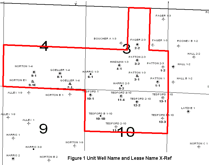
Figure 1 is a map showing the
locations of wells in the general area that includes the Minneola
unit. The figure also shows the boundary of the Minneola unit
along with the well locations, well names, and corresponding unit
numbers. The producing horizon in the field is the Morrow sandstone.
The reservoir drive mechanism is solution gas drive. The initial
oil production varied from 38 to 164 bopd with many of the wells
producing associated gas. DST analyses show that wells completed
in early half of 1983 averaged an initial reservoir pressure of
1555 psi while those completed in 1985 averaged 817 psi. Production
from a solution gas drive reservoir without any pressure support
resulted in a rapid decline of reservoir pressure. By June 1993,
the production from the Minneola unit had dropped to 26 bopd after
a cumulative production of 555304 barrels of oil and 1087 MMcf
of associated gas. By 1993, the wells in the unitized area were
approaching economic limits under primary production.
 In 1994, for the purposes of secondary
recovery, 13 tracts, all operated by Murfin Drilling Co., were
unitized to initiate a water-flooding program. The area unitized
covers about 1040 acres and includes the W/2 of the NE/4, and
the S/2 of section 3; the S/2 of section 4; and the N/2 of section
10; all in 30s-25w, Clark County, Kansas. Included in the unitized
area are 12 producing wells and 2 water injection wells. The Patton
#1-3 (unit # 3-1) and Goeller #1-4 (unit #7-1) were converted
into injection wells.
The objective of this study is to evaluate the performance
of waterflooding in the Minneola Unit. As a part of this exercise,
a geologic model has been constructed from the petrophysical logs.
Available DST data were analyzed to determine the initial reservoir
pressures and effective permeabilities. Data from the petrophysical
logs were used to construct Super-Pickett plots to calculate average
pay thickness, porosity and initial saturations. Laboratory measurements
on core plug were used to generate permeability versus porosity
correlation. This correlation was used to develop a permeability
map, using log-derived porosity, for the unitized area. The available
production data, since waterflooding, were analyzed at the unit
level and also at the well level to understand the performance
of the waterflooding.
The URL for this page is http://www.kgs.ku.edu/DPA/Reports/Minneola/index.html
February 2000
Please send comments to webadmin@kgs.ku.edu
 In 1994, for the purposes of secondary
recovery, 13 tracts, all operated by Murfin Drilling Co., were
unitized to initiate a water-flooding program. The area unitized
covers about 1040 acres and includes the W/2 of the NE/4, and
the S/2 of section 3; the S/2 of section 4; and the N/2 of section
10; all in 30s-25w, Clark County, Kansas. Included in the unitized
area are 12 producing wells and 2 water injection wells. The Patton
#1-3 (unit # 3-1) and Goeller #1-4 (unit #7-1) were converted
into injection wells.