


|
Preparation of Northern Mid-Continent Petroleum Atlas--Reporting Period:
April 1, 1996 -- June 30,1996
|
Cooperative Agreement No.: DE-FG22-95BC14817
Contractor Name and Address: The University of Kansas Center for Research
Inc.
Date of Report: July 15, 1996
Award Date: August 24, 1995
Government Award for Current Fiscal Year: $ 250,000
Principal Investigators:
Project Manager: Chandra Nautiyal, Bartlesville Project Office
Reporting Period: April 1, 1996 -- June 30,1996
Objectives
Project will develop a prototype for a digital and hard-copy atlas of petroleum
fields and reservoirs in the northern Mid-continent region. A limited number
of reservoirs in Kansas are to be included in the prototype project, but
the goal is to expand beyond the prototype atlas to include significant
reservoirs representing the major plays in Kansas, Nebraska, South Dakota,
North Dakota, the Williston basin portion of Montana, the Denver-Julesburg
basin of eastern Colorado and southeastern Colorado.
Primary products of the prototype atlas will be on-line accessible digital
data bases covering two selected petroleum plays in Kansas. The regional
databases will be supplemented with geological field studies of selected
fields in each play. Digital imagery, digital mapping, relational data queries,
and geographical information systems will be integral to the field studies
and regional data sets. Data sets will have relational links to provide
opportunity for history-matching, feasibility, and risk analysis tests on
contemplated exploration and development projects. The flexible "web-like"
design of the atlas provides ready access to data, and technology at a variety
of scales from regional, to field, to lease, and finally to the individual
bore. The digital structure of the atlas permits the operator to access
comprehensive reservoir data and customize the interpretative products (e.g.,
maps and cross-sections) to their needs. The atlas will be accessible in
digital form on-line and through CD-ROM using a World-Wide-Web browser as
the graphical user interface.
Regional data sets and field studies will be free-standing entities that
will be made available on-line through the Internet to users as they are
completed. Technology transfer activities will commence in the early part
of this project, providing data information sets to operators prior to the
full digital atlas compilation.
Summary of Technical Progress
"Pages" and data schema for the atlas overview and field studies
have been developed and are accessible through the world-wide-web. The atlas
structure includes access to geologic, geophysical and production information
at levels from the national, to the regional, to the field to the individual
well. Several approaches have been developed that provide efficient and
flexible screening and search procedures. The prototype of the digital atlas
is accessible through the Kansas Geological Survey Petroleum Research Section
(PRS) HomePage (The Universal Resource Locator [URL] is http://www.kgs.ku.edu/PRS/PRS.html).
The Digital Petroleum Atlas (DPA) HomePage is available directly at http://www.kgs.ku.edu/DPA/dpaHome.html.
Technology transfer is underway through the use of monthly electronic updates
and the on-line availability of the DPA products. Project information and
Quarterly Progress Reports are linked to the Digital Petroleum Atlas HomePage.
On-line Prototype
The prototype digital atlas is being designed, tested and constructed. At
present the prototype covers Arroyo, Big Bow and Gentzler fields. The present
prototype design consists of the following components:
- DPA HomePage: http://www.kgs.ku.edu/DPA/dpaHome.html
- The DPA Homepage has been expanded to include links to project information,
such as progress and topical reports, and to discussions of plays, basins
and geological provinces at both the national and Kansas levels. Much of
the information at the national and province level is from the US
Geological Survey 1995 National Assessment of United States Oil and
Gas Resources (available on CD-ROM from the USGS as Digital Data Series
DDS-30, Release 2). The USGS material will be supplemented with additional
regional material covering the Kansas basins. Included in the discussion
are maps of regions and geologic provinces, overview discussions, historical
data and quick-time movies of the exploration history at national, province,
basin, and play levels. All information is linked through graphical user
interfaces. Examples can be found at
National Level: http://www.kgs.ku.edu/DPA/frontEnd/regions1.html
Province Level: http://www.kgs.ku.edu/DPA/frontEnd/Region/midcontinent.html
(Midcontinent Province)
Basin Level: http://www.kgs.ku.edu/DPA/frontEnd/Anadarko/anadarko.html
(Anadarko Basin)
Play Level: http://www.kgs.ku.edu/DPA/frontEnd/Anadarko/Morrow/morrow.html
(Morrow Play).
Also included on the DPA Homepage is an expandable listing of producing
regions, basins and plays (http://www.kgs.ku.edu/DPA/frontEnd/Plays/regionList1.html).
Clicking on the plus will provide links to more detailed information
while clicking on the minus will show less detailed information about the
selected region, province or play.
Access to the Kansas DPA Homepage is through the National DPA HomePage.
Kansas DPA HomePage: http://www.kgs.ku.edu/DPA/dpaKansas.html
- Parameter Searches:
- Fields and wells can now be searched by geographic location, name (API
number or field name) and in the case of fields by a flexible search routine
that incorporates production and geologic parameters. Searching fields by
parameters can be accessed at [replaced by http://www.kgs.ku.edu/Magellan/Field/index.html].
As an example a search on all fields in Kansas discovered since 1985 that
had cumulative oil production greater than 500,000 barrels returned the
names and summary data for 24 fields. Arroyo
and Big Bow
fields are among the list and are returned as active links that can be used
to access additional information.
- County Maps:
- Regional maps show the field outlines and provide access to selected
geologic and geophysical maps. Click on the name of the field to go to pages
about that field. Access through a GUI stratigraphic column to show structure
or isopach maps. Four counties are complete and 30 additional counties provide
access through oil and gas field outline maps.
- Field Title Page:
- Outline of producing leases; location of discovery well(s), condensed
field statistics, and access to field production data. Additional information
was added to all the fields covered by the Atlas. In addition, preliminary
data has been added for the Gentzler
Field in Stevens County.
- Regional Setting:
- The regional setting page provides a geologic and production perspective
at a regional scale. Improvements include additional geologic and geophysical
information covering Stanton, Grant, Stevens and Ness counties.
- General Information:
- Basic geologic, geophysical, fluid, engineering, completion, and production
data at the field scale.
- Geological Information:
- Access to geologic field maps and cross-sections though a type log graphical
user interface. Clicking on selected horizon provides access to multiple
maps at different levels.
- Geophysical Information:
- At present, geophysical data for Arroyo Field in Stanton County is available.
- Reservoir Information:
- In the case of Arroyo Field this page contians access to petrophysical
plots and to core descriptions http://www.kgs.ku.edu/DPA/Arroyo/Reservoir/arroyoRese1.html.
The page will contain additional reservoir engineering and geologic information.
- Well Information
- Provides access to information on a single wellbore. Access is through
an interactive map (click on the well symbol) and through a forms-based
search. Data includes raster image of original completion report, digital
"scout ticket" data, production data in graphical and digital
formats, and digital log data. Prototype pages have been developed for presentation
of core data (such as core photos, porosity and permeability data, descriptions,
and thin-sections). Additional wells were added for Gentzler Field in Stevens
County (http://www.kgs.ku.edu/DPA/Gentzler/gentzlerMain.html
).
All components are accessible through a standard suite of "buttons"
that are at the bottom of every page.
Technology Transfer
The prototype Digital Petroleum Atlas continues to be one of the most visited
pages on the Kansas Geological Survey web site (Current usage statistics
can be accessed at the bottom of the Petroleum Research Section HomePage
or at http://www.kgs.ku.edu/PRS/usage/past_stats.html).
Usage has steadily increased to over 5,000 access "hits" per week
(Figure 1). A presentation at the Society of Independent Petroleum Earth
Scientists (SIPES) national convention in Dallas, and a booth at the national
convention of the AAPG were well received. Presentations featuring the DPA
are scheduled for the annual meeting of the Kansas Independent Oil and Gas
Association (KIOGA) on August 26 and at an educational seminar for the Kansas
Petroleum Council on September 18.
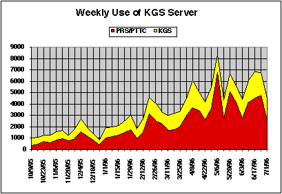
Figure 1.-- Usage of the Petroleum Research Section (PRS) and Kansas Geological
Survey web site through the week of 15 April, 1996. Updated graph and detailed
statistics are available at http://www.kgs.ku.edu/PRS/usage/past_stats.html.
Back to DPA Home
Kansas Geological Survey, Digital Petroleum Atlas
Updated July 15, 1996
URL = http://www.kgs.ku.edu/DPA/Reports/July1996.html