|
|
Preparation of Northern Mid-Continent Petroleum Atlas--Reporting Period: October 1, 1996 -- December 31,1996 |
Cooperative Agreement No.: DE-FG22-96BC14844
Contractor Name and Address: The University of Kansas Center for
Research Inc.
Date of Report: February 4, 1997
Award Date: August 30, 1996
Government Award for Current Fiscal Year: $ 250,000
Project Manager: Chandra Nautiyal, Bartlesville Project Office
Reporting Period: October 1, 1996 -- December 31,1996
As proposed, the second year program will continue and expand upon the Kansas elements of the original program, and provide improved on-line access to the prototype atlas. The second year of the program will result in a prototype digital atlas sufficient to demonstrate the approach and to provide a permanent improvement in data access to Kansas operators. The ultimate goal of providing an interactive history-matching interface with a regional data base remains for future development as the program covers more geographic territory and the data base expands. The long-term goal is to expand beyond the prototype atlas to include significant reservoirs representing the major plays in Kansas, Nebraska, South Dakota, North Dakota, the Williston basin portion of Montana, the Denver-Julesburg basin of eastern Colorado and southeastern Colorado.
Primary products of the second year prototype atlas will be on-line accessible digital data bases covering two additional petroleum plays in Kansas. Regional databases will be supplemented with geological field studies of selected fields in each play. Digital imagery, digital mapping, relational data queries, and geographical information systems will be integral to the field studies and regional data sets. Data sets will have relational links to provide opportunity for history-matching, feasibility, and risk analysis tests on contemplated exploration and development projects. The flexible "web-like" design of the atlas provides ready access to data, and technology at a variety of scales from regional, to field, to lease, and finally to the individual well bore. The digital structure of the atlas permits the operator to access comprehensive reservoir data and customize the interpretative products (e.g., maps and cross-sections) to their needs. The atlas will be accessible in digital form on-line using a World-Wide-Web browser as the graphical user interface.
Regional data sets and field studies will be free-standing entities that will be made available on-line through the Internet to users as they are completed. Technology transfer activities will be ongoing from the earliest part of this project, providing data information sets to operators prior to the full digital atlas compilation.
As part of the first year project "Pages" and data schema for the
atlas overview and field studies were developed and made accessible
through the world-wide-web. The atlas structure includes access to
geologic, geophysical and production information at levels from the
national, to the regional, to the field to the individual well.
Several approaches have been developed that provide efficient and
flexible screening and search procedures. The prototype of the
digital atlas is accessible through the Kansas Geological Survey
Petroleum Research Section (PRS) HomePage (The Universal Resource
Locator [URL] is
http://www.kgs.ku.edu/PRS/PRS.html).
The Digital Petroleum Atlas (DPA) HomePage is available directly at
http://www.kgs.ku.edu/DPA/dpaHome.html.
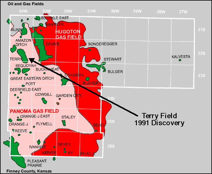
The multi-pay Terry Field in Finney County was selected for inclusion in the DPA. Terry Field was a 1991 discovery with primary producing zones in the Lansing-Kansas City, Marmaton and Mississippian. A number of county scale geologic maps are being generated and will be loaded into the DPA. Well-log and other well information for Terry Field are being collected and a field study is underway.
The following changes and additions have occurred to the on-line
prototype atlas.
DPA
HomePage:
http://www.kgs.ku.edu/DPA/dpaHome.html
On the DPA Homepage
(http://www.kgs.ku.edu/DPA/dpaHome.html),
a new set of navigation buttons for the national, Northern
Mid-continent and Kansas levels of the DPA provides clear separation
for efforts in the different areas. Most of our efforts are placed in
Kansas, but we will add significant information to the other areas. A
report on electronic publication in the earth sciences that will be
published in COMPUTERS AND GEOSCIENCES is available through a link to
the DPA Homepage.
Kansas HomePage:
http://www.kgs.ku.edu/DPA/dpaKansas.html
Residual Bouguer gravity and reduced-to-the-pole magnetic data and
maps of Kansas are available through the Kansas regional geologic
setting page
(http://www.kgs.ku.edu/DPA/regional.html).
Small scale maps with selected overlays can be viewed on-line or
larger scale maps can be downloaded. Overlays include county lines,
outlines of oil and gas fields, Post-Mississippian structure and
Precambrian structure. A general discussion of the gravity and
magnetic data is provided.
Field Pages: various URLís
Additional information was added to the Arroyo, Big Bow, Gentzler and Schaben fields. Production data at the field and lease level is being updated through 1996.
Technology transfer is ongoing through presentations at national and regional meetings and through the use of monthly electronic updates and the on-line availability of the DPA products. Project information and Progress Reports are linked to the Digital Petroleum Atlas HomePage. The prototype Digital Petroleum Atlas remains one of the most visited pages on the Kansas Geological Survey web site (Current usage statistics can be accessed at the bottom of the Petroleum Research Section HomePage or at http://www.kgs.ku.edu/PRS/usage/past_stats.html). Presentations were given at the Annual Meeting of the Geological Society of America on October 28 and the Interstate Oil and Gas Compact Commission (IOGCC) Annual Meeting on December 9. Additional presentations are scheduled at the Powder River Basin Section of SPE on May 14 and at the Annual Meeting of the American Association of Petroleum Geologists on April 9 (Appendix A). An abstract was submitted for the annual meeting of the Society of Petroleum Engineers (SPE). Papers, citing the Digital Petroleum Atlas as an example of new forms of on-line publication, are in press for COMPUTERS AND GEOSCIENCES and the PROCEEDINGS OF THE GEOSCIENCE INFORMATION SOCIETY.
Abstract for Annual Meeting of the American Association of
Petroleum Geologists on April 6-9
Scientific Communication in the Earth Sciences:
The Impact of the Electronic Publication
TIMOTHY R. CARR; DANA ADKINS-HELJESON; REX C. BUCHANAN; PAUL GERLACH; THOMAS D. METTILLE; and JANICE H. SORENSEN; Kansas Geological Survey, University of Kansas, Lawrence, KS
Traditional paper media, such as
books, monographs, journals, and maps. have been a recognizable
aspect of geologic work for several centuries. They remain the
primary medium for communicating research results, transferring
technology, and archiving knowledge. However, continued growth in
volume of earth-science literature, increased unit costs of producing
and archiving paper publications, and rapidly increasing power and
availability of electronic technology are creating pressures on
traditional scientific communication, and rapidly altering the role
of traditional publication as a means of scientific communication.
Electronic publication provides broad access and alters the
relationship between interpretative result and the data. Electronic
technology improves the quality and accessibility of
ìnon-traditionalî research products, (e.g., digital
geographic information and unpublished archival material), and
provides the means to create dynamic forms of scientific
communication that can only be displayed in an electronic
environment. New forms of communication use hypertext and relational
database functions to provide text and graphics with which readers
can interact. Electronic publication improves research
reproducibility and facilitates use and continued enhancement of
research products. Earth science institutions, including the Kansas
Geological Survey, are experimenting with new forms of on-line
publication that assure broad access to research and data, and
improve application of research to societal problems.
Back to DPA Home
Kansas Geological Survey, Digital Petroleum Atlas
Updated February 19, 1997
URL = http://www.kgs.ku.edu/DPA/Reports/DPA-qtr4-96.html