|
|
Preparation of Northern Mid-Continent Petroleum Atlas--Reporting Period: August 24, 1995 -- November 23,1996 |
Cooperative Agreement No.:
DE-FG22-95BC14817
Contractor Name and Address: The University of Kansas Center for
Research Inc.
Date of Report: February 10, 1997
Award Date: August 24, 1995
Government Award for Current Fiscal Year: $ 250,000
Principal Investigators:
Project Manager: Chandra Nautiyal, Bartlesville Project Office
Reporting Period: August 24, 1995 -- November 23,1996
- Forward
- Abstract
- Executive summary
- Introduction
- Traditional Petroleum Atlas
- Change in Scientific and Technical Publication
- Usage of the Prototype Digital Petroleum Atlas
- Results and Discussion
- Atlas Structure
- Digital Petroleum Atlas HomePage
- US Regions and Geologic Provinces HomePage
- Northern Midcontinent HomePage
- Kansas Digital Petroleum Atlas HomePage
- Atlas Navigation
- Navigational Button
- Interactive Image Maps
- Search Engines
- Technology Transfer Activities
- Problems Encountered
- Recommendations for Future Work
- Conclusions
- References Cited
- Appendix A: Selected Abstracts
Project members and contributors to this report include: Dana Adkins-Heljeson, Saibal Bhattacharya, Tim Carr, Lee C Gerhard, Paul Gerlach, Willard Guy, Joseph Kruger, W. Lynn Watney and Wyatt Weeks. A digital copy of the report is available through the Digital Petroleum Atlas home page (this report or PDF format)
The prototype Digital Petroleum Atlas (DPA) Project is part of a long-term effort to develop a new methodology to provide efficient and timely access to the latest petroleum data and technology for the domestic oil and gas industry, public sector research organizations and local governmental units. The DPA provides real-time access through the Internet using widely available tools such as World-Wide-Web browsers. The latest technologies and information are ìpublishedî electronically when individual project components are completed removing the lag and expense of transferring technology using traditional paper publication. Active links, graphical user interfaces and database search mechanisms of the DPA provide a product with which the operator can interact in ways that are impossible in the paper publication. Contained in the DPA are forms of publication that can only be displayed in an electronic environment (for example, animated exploration histories through time). Improvement in data and technology access for the domestic petroleum industry represents one of the best and cost-effective options that is available for mitigating the continued decline in domestic production.
The prototype DPA concentrated on developing methodologies and computerized procedures to generate and to ìpublishî a limited set of field and play studies concentrated in Kansas and to a lesser extent the Northern Mid-continent. Access is provided through the DPA to previously existing and new regional, play, field and individual well information. Methodologies, developed in year one of the prototype DPA Project, provide a ìpublishedî product and ongoing technology transfer activity that is continuously updated with the latest information and technology.
The prototype Digital Petroleum Atlas (DPA) Project is the first
year of a long-term effort to develop a new methodology to provide
efficient and timely access to the latest petroleum data and
technology for the domestic oil and gas industry, public sector
research organizations and local governmental units. The DPA provides
real-time access through the Internet using widely available tools
such as World-Wide-Web browsers. The latest technologies and
information are ìpublishedî electronically when
individual project components are completed removing the lag and
expense of transferring technology using traditional paper
publication. Active links, graphical user interfaces and database
search mechanisms of the DPA provide a product with which the
operator can interact in ways that are impossible in the paper
publication. Contained in the DPA are forms of publication that can
only be displayed in an electronic environment (for example, animated
exploration histories through time). Improvement in data and
technology access for the domestic petroleum industry represents one
of the best and cost-effective options that is available for
mitigating the continued decline in domestic production.
The prototype DPA concentrated on developing methodologies and
computerized procedures to generate and to ìpublishî a
limited set of field and play studies concentrated in Kansas and to a
lesser extent the Northern Mid-continent. Kansas fields studied
include: Arroyo Field (Morrowan), Stanton County; Big Bow Field (St.
Louis), Grant and Stanton counties; and Gentzler Field (Morrowan),
Stevens County. Access is provided through the DPA to previously
existing and new regional, play, field and individual well
information. Methodologies, developed in year one of the prototype
DPA Project, provide a ìpublishedî product and ongoing
technology transfer activity that is continuously updated with the
latest information and technology.
Through complete and flexible user access to technology, interpretative products and the underlying geologic and petroleum data, the DPA alters the relationship between interpretative result and data, between technology generation and application.
Oil production in the United States has steadily declined, while
consumption and imports are steadily increasing. In September of 1985
the nation produced over 10,636,000 barrels of oil per day
(http://www.eia.doe.gov/oil_gas/petroleum/pet_frame.html).
For the first 11 months of 1996, production dropped to 8,604,000
barrels per day. Imports have risen from 4,286,000 barrels of oil per
day in 1985 (28% of demand) to 8,400,000 barrels of oil per day in
1996
(http://www.eia.doe.gov/oil_gas/petroleum/pet_frame.html).
By the end of 1996, import to demand ratio will probably exceed 50%.
To help mitigate the decline in U.S. oil production, the United
States Department of Energy (USDOE) has initiated programs that
enable and encourage development of innovative technologies, and
promote the transfer and application of technologies to petroleum
operators of all sizes, but especially independent operators.
Independent operators now dominate the domestic petroleum industry.
Through these methods, the USDOE intends that significant additional
production that otherwise would be produced.
One of the most effective methods to gain additional production
from known reserves, to add new reserves and to prevent the premature
abandonment of wells is to provide oil and gas producers with the
access to up-to-date information and technology. The critical
information and technology can vary among fields, reservoirs and
operators. As an example, a key for one type of reservoir might be
sophisticated, inexpensive ways to identify unswept compartments; and
for another field type the key might be optional and optimal
techniques for additional workover, completion, and production
practices that have been successful in analog fields.
Short of conducting a full-scale reservoir analysis of each producing field, an efficient and effective method of communicating this type of key information to operators is by example. For each reservoir type in a producing region, a thoroughly studied and documented analog can illustrate which geologic and engineering procedures
are likely to be most successful in increasing ultimate recovery. An analog example provides operators with sufficient information and technology to apply their own producing properties, and increase production and ultimate recovery by copying, modifying and applying proven methods. One way to accomplish the goal of disseminating information by analog is to provide a geological and engineering based, state-of-the-art, petroleum atlas that contains not only historical data and descriptions, but technologically advanced syntheses and analyses of "why reservoirs produce" and "how ultimate production may be increased."
Compilation of reservoir, field and play studies into a published
petroleum atlas is a time honored approach to illustrating by analog
the latest petroleum exploration and development knowledge and
application. Notable compilations of such studies include:
Structure of Typical American Fields (Powers, 1929); Giant
Fields of 1968-1978 (Halbouty, 1981); Treatise of Petroleum
Geology: Atlas of Oil and Gas Fields (Beaumont and Foster, 1990;
Foster and Beaumont, 1991; 1992), Atlas of Major Texas Oil
Reservoirs (Galloway and others, 1983), Atlas of Midcontinent
Gas Reservoirs (Bebout and others, 1993), and Atlas of Major
Rocky Mountain Gas Reservoirs (Robertson and others, 1993). The
underlying goals of these petroleum atlases have been to:
Various formats have been developed to facilitate data access, and
to meet the requirements and limitations of the particular paper
publication. Table 1 shows a generalized format that is common to
many of these compilations. The traditional published atlas is a time
consuming and expensive process that results in static paper product.
Products and data are typically limited by space and cost
considerations to summary information at the field or reservoir
level. For each play, field or reservoir only a relatively small
number of author-selected maps, cross-sections, charts and other
summary data are included. The paper atlas does not provide access to
well and lease data or to intermediate research products (such as
digital geographic and geologic components of maps, interpreted and
uninterpreted subsurface data, geochemical analyses, thin section
images, and other traditionally unpublished material). Without access
to the data and intermediate products, modifying and updating a
published field study to fit particular applications or new
scientific ideas is a difficult and time consuming process.
Table 1.-- Generalized format outline that is typical for a traditional published atlas containing field, reservoir or play studies (Modified from Beaumont and Foster, 1990).
- Location of Play, Field or Reservoir
- History
Pre-Discovery
Discovery
Post Discovery
- Discovery Method
- Structure
Tectonic History
Regional Structure
Local Structure- Stratigraphy
- Trap
General Description
Reservoir(s)
Source(s)
- Exploration Concepts
- Development Concepts
- Production Concepts
The traditional role of scientific and technical publication is to
formalize and record scientific and technical results in time, and to
transfer technology to potential users (Kerkhof, 1994). Over the past
century and possibly even in the previous decade, the paper report,
journal, monograph or book was the fastest and most efficient method
to disseminate, validate, and archive research and technical results.
Today, traditional channels of scientific and technical communication
are being challenged by the shear volume of publication, the
increased unit costs, the relatively decreased resources of academic
and industrial library systems, and the rapidity of technical change
(Okerson, 1992). In addition, the growth of networks, storage
servers, printers, and software that make up the Internet is rapidly
changing the world from one in which research organizations,
publishers and libraries control the printing, distribution, and
archiving to a world in which individuals can rapidly and cheaply
ìpublishî, provide access and modify scientific results
on-line. These changes offer significant challenges and opportunities
to the various participants and traditions of scientific and
technical publication (Denning and Rous, 1995).
Another drawback of traditional published scientific and technical
results is the limitation of paper (cost and space) causing incomplete documentation of the research
process. As a result it is often difficult to replicate or
modify traditional paper-published research (Claerbout, 1994). The
purpose of reproducing research is to transfer research products to
the user, to validate research results, and to facilitate extending
the research to better fit user needs. Reproduction of research is a
fundamental problem in technology transfer in the earth sciences.
This problem has been attributed to loss of steps along the research
pathway (Claerbout, 1994). Lack of access to theory, methods, data,
or results may form a missing step in the earth sciences. For
example, it is not common practice to publish detailed production
data, well logs, and analyses that formed the basis of a reservoir or
field study or map. With the increased publication costs these data
are at best archived. The result is a finished product that is
difficult to replicate, validate, or modify to new needs or
opportunities. The resource investment required to reproduce
published research may take many months and forms a barrier to
technology transfer of fundamental, regional or site specific
petroleum research. This barrier is a significant impediment to
merging results from disparate scientific fields into research
solutions for societal and industrial problems and for providing
timely scientific information for policy decisions. The shortening
life cycles of technology and the increased needs for
cross-disciplinary research require a change in the unit of research
from the published paper to an easily adapted technologic
solution.
The
Midcontinent Digital Petroleum Atlas radically changes
traditional models and approaches to generating and disseminating
petroleum field, play and basin studies (Carr and others, in press).
The Digital Petroleum Atlas (DPA) is an electronic publication that
is available on-line over the world-wide-web. The DPA is designed to
provide easily adapted technologic solutions and to be a dynamic
product that is constantly evolving with new structure, research
results, and data. Through complete and flexible user access to both
the interpretative products and the underlying reservoir and well
data, the DPA alters the relationship between interpretative result
and data.
The first year of the DPA Project developed a prototype for a
digital atlas of petroleum fields and reservoirs in Kansas. A very
limited number of reservoirs in Kansas were included in the prototype
project, but the goal is to expand beyond the prototype atlas to
include all significant reservoirs representing the major plays in
the Northern Midcontinent (Figure 1a). The Northern Midcontinent as
defined for the DPA includes all of Kansas, Nebraska, South Dakota,
North Dakota, the Williston basin portion of Montana, and the
Denver-Julesburg basin of eastern Colorado (Figure 1b).
The DPA was constructed using standardized templates and
navigation tools to give the product a consistent look and feel.
Active links, graphical user interfaces and database search
mechanisms provide a product with which the reader can interact in
ways that are impossible in a paper atlas. The DPA also contains
forms of publication that can only be displayed in an electronic
environment. These electronic only forms of publication include:
searches based on user-defined geologic, engineering and production
criteria; hypertext search and manipulation functions to generate
customized maps and plots; and access to animated products (e.g.,
exploration histories through time). Electronic products such as the
DPA are far more efficient tools for rapid technology transfer and
resource sharing. The DPA can use available digital materials to
create on-demand products that better fit user-defined needs.
Primary products of the prototype atlas are on-line accessible
digital data bases covering two significant petroleum plays in
Kansas. The regional databases are supplemented with selected
geological field studies in each play. Digital imagery, digital
mapping, relational data queries, and geographical information
systems are integral to the field studies and regional data sets.
Data sets have relational links to provide opportunity for
history-matching, feasibility, and risk analysis tests on
contemplated exploration and development projects. The flexible
"web-like" design of the atlas provides ready access to data, and
technology at a variety of scales from regional, to field, to lease,
and finally to the individual bore. The digital structure of the
atlas permits the operator to access comprehensive reservoir data,
interpretative products (e.g., maps and cross-sections) and to
customize the products to their needs. The atlas is accessible in
digital form on-line using a World-Wide-Web browser as the graphical
user interface.
Regional data sets and field studies are free-standing entities that are made available on-line through the Internet to users as they are completed. Technology transfer activities commenced in the early part of this project, providing data information sets to oil and gas operators, government and research organizations and other interested individuals prior to the full digital atlas compilation.
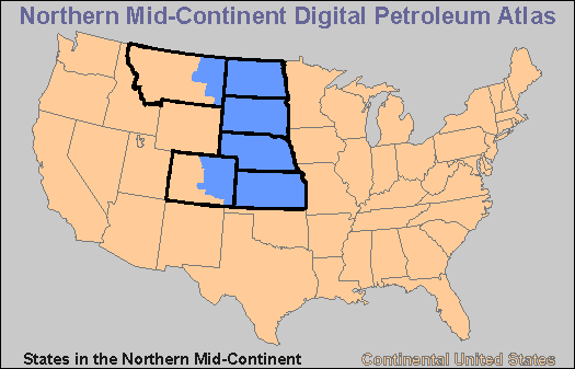
Figure 1. a) Map showing area covered by the proposed Northern Mid-continent Digital Petroleum Atlas (http://www.kgs.ku.edu/DPA/NMC/nmc.html).
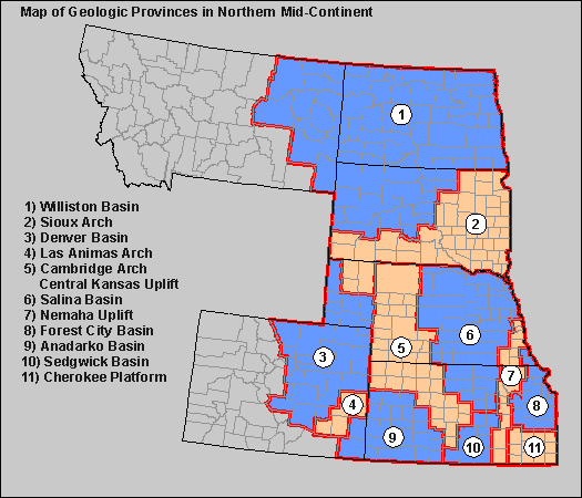
Figure 1. b) Interactive map of geologic provinces (http://www.kgs.ku.edu/ DPA/NMC/nmcProv.html).
Since the prototype Digital Petroleum Atlas is an electronic
publication, on-line access was provided to the public soon after
project inception. Use of the DPA products was almost immediate and
has grown steadily over the year
(Figure 2). This near real-time
transfer of technology and information to the client is one advantage
demonstrated by the DPA.
The pages that comprise the DPA make up the bulk of the web site for the Petroleum Research Section (PRS) of the Kansas Geological Survey. Usage statistics show that access to these pages has grown steadily from 1,000 to over 5,000 access ìhitsî per week (Figure 2). In measuring access ìhitsî on the PRS site, all access to graphics is removed. This eliminates the multiple counting of access hits that result from multiple figures (buttons, bars, arrows, etc.) on a single web page. In addition, all access from the Kansas Geological Survey subdomain (kgs.ku.edu) is removed. This measurement protocal produces a consistent and conservative measure of external usage. Current usage statistics are collected daily and weekly and are available on the Petroleum Research Section of the Kansas Geological Survey web site (http://www.kgs.ku.edu/usage/past_stats.html).
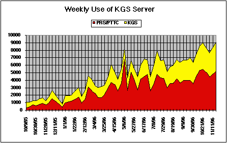
Figure 2. Weekly usage statistics measuring separate pages viewed. Miscellaneous graphics and access from Kansas Geological Survey computers are removed prior to analysis. Current usage statistics are collected daily and weekly and are available on the Petroleum Research Section of the Kansas Geological Survey web site (http://www.kgs.ku.edu/usage/past_stats.html).
The prototype digital petroleum atlas is constructed around a set of basic units called "homepages" The homepages are organized into a loose hierarchy from the general overview of the project, increasing in detail though the regional, play and field scales. At the greatest level of detal are individual web pages that provide technology, information and data on a focused topical discussion, a well bore or a single analysis from a well. Each homepage provides a point of access to number of ìpagesî containing relevant information and technology. Navigation among pages is provided by a set of standardized tools or through search engines. The navigation tools permit the user to move through the DPA in a more or less linear path, similar to a traditional book, or to skip rapidly among related subjects and scales. The Digital Petroleum Atlas leverages the power of electronic publication through numerous cross-links, the ìweb-likeî non-linear structure and search engines. The client has the power to tailor access and the final products to fit user-defined requirements and needs.
The Digital Petroleum Atlas HomePage provides an overview and one of many points entrance to the DPA project (http://www.kgs.ku.edu/DPA/dpaHome.html). The DPA HomePage provides links to overall project information, quarterly progress reports and topical reports (Figure 3). As part of a methodology section, an interactive schematic map of the entire DPA project is provided (http://www.kgs.ku.edu/DPA/dpaMap.html). The site map provides a graphical overview of the DPA structure and progress. The DPA site map is also an interactive graphical user interface (GUI) that can be used to directly navigate to specific areas of the DPA (Figure 4). A status chart of DPA progress, also included under the methodology section, provides a more more detailed look at progress of each atlas component down to the field level (Figure 5, (http://www.kgs.ku.edu/DPA/Reports/statusChart.html).
The DPA HomePage also provides active links to DPA information at the Bartlesville Project Office of the US Department of Energy (e.g., Project Fact Sheets) and to the Department of Energy homepage. The DPA project contains petroleum information at three geographically defined levels -- national, Northern Midcontinent region and Kansas. Each level is a homepage that provides access to discussion of plays, basins and geological provinces and to information and technology focused on individual fields, reservoirs and wells. Regional geologic and petroleum prespectives were developed that span and link the three geographically defined levels. As part of the prototype, work on individual fields, reservoirs and wells was restricted to Kansas. However, the structure and methodologies are designed to be appropriate for focused petroleum studies throught the US. All discussion topics and levels are cross-linked and searchable across geographic boundaries providing the user unrestricted access across all DPA components.
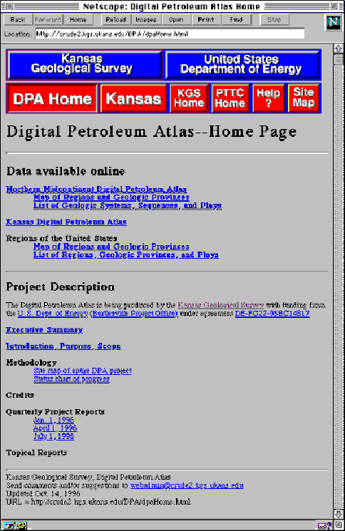
Figure 3. Digital Petroleum HomePage provides background information and links to other areas of the DPA (http://www.kgs.ku.edu/DPA/dpaHome.html).
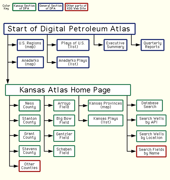
Figure 4. Digital Petroleum Atlas Site Map shows the overall DPA structure and status. The site map also provides an user way navigate to specific areas of the atlas (http://www.kgs.ku.edu/DPA/dpaMap.html).
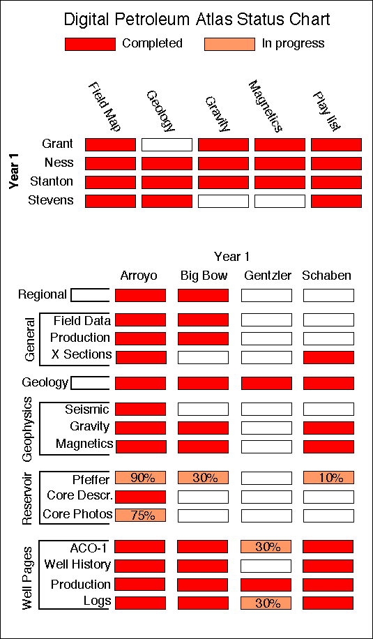
Figure 5. Status chart for the prototype Digital Petroleum Atlas showing the status of individual atlas components down to the field level (http://www.kgs.ku.edu/DPA/Reports/statusChart.html).
United States Regions HomePage provides links to maps of regions and geologic provinces, overview discussions, historical data and Quick Time movies of the exploration history at national, province, basin, and play levels. All information is linked through graphical user interfaces (http://www.kgs.ku.edu/DPA/frontEnd/regions1.html).
Information at the national and province level is from the US Geological Survey 1995 National Assessment of United States Oil and Gas Resources (available on CD-ROM from the U.S.G.S. as Digital Data Series DDS-30, Release 2). The U. S. G. S. material has been supplemented and in some cases replaced by regional and play material covering the Kansas basins. All regional information is linked through graphical user interfaces.
The Northern Mid-continent HomePage provides interactive maps and expanding lists that outline the region and its geologic provinces (http://www.kgs.ku.edu/DPA/NMC/nmc.html). The long-term goal of the DPA project remains to expand beyond the prototype atlas in Kansas in order to include all significant reservoirs representing the major plays in the Northern Mid-continent (Figure 1a). The Northern Midcontinent as defined for the DPA includes all of Kansas, Nebraska, South Dakota, North Dakota, the Williston basin portion of Montana, and the Denver-Julesburg basin of eastern Colorado (Figure 1b). From the Northern Mid-continent HomePage one can access similar regional information as is found on the US Regions HomePage. Included on the Northern Mid-continent HomePage are links to
The system, sequence and play lists expand to provide more detail. As an example the Pennsylvanian, Lower Absaroka Sequence will provide access to a set of regional maps (paleogeography and accumulation rates) and a list of plays associated with this sequence throughout the region (http://www.kgs.ku.edu/DPA/NMC/Seq/penn.html). Selecting the Morrow Sandstone Gas and Oil Stratigraphic Play in the Anadarko Basin provides the regional detail on the this particular play with summary, estimate of resources, accumulation versus size graphs, etc. (http://www.kgs.ku.edu/DPA/frontEnd/Anadarko/Morrow/morrow.html). Detailed discussion is restricted to the Mississippian and Morrow plays of Kansas that were part of the one year prototype. However this architecture provides a methodology for covering similar plays across different basins and states.
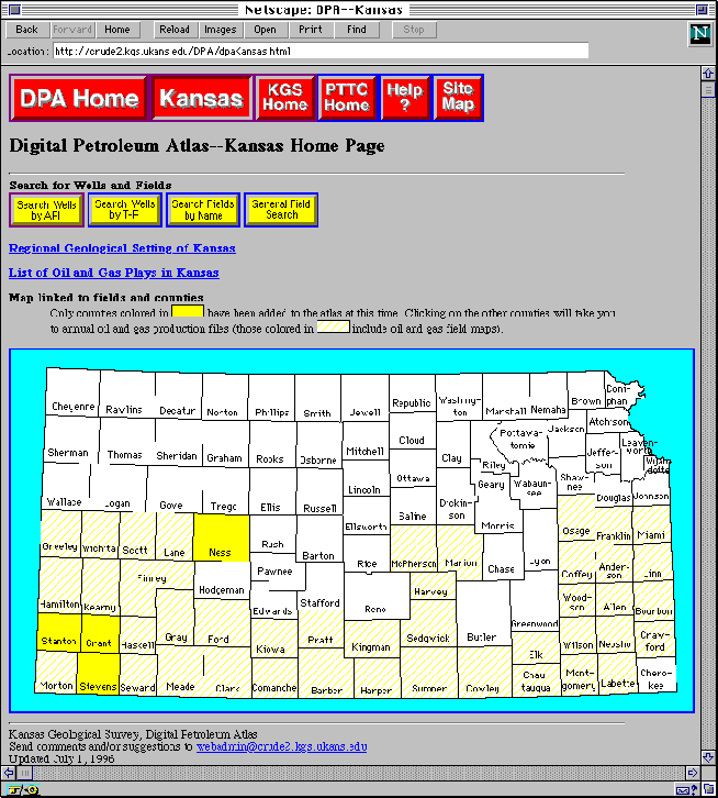
Figure 6. Kansas DPA HomePage provides access to petroleum information and technology for Kansas plays, fields, reservoirs and wells (http://www.kgs.ku.edu/DPA/dpaKansas.html).

Figure 7. Map of Geologic Provinces in Kansas. Map is a graphical user interface that provides access to plays and additional information about each geologic province (http://www.kgs.ku.edu/DPA/Plays/ksProv.html).

Figure 8. a) Map of distribution of Morrowan oil and gas production in the Anadarko Basin Province of Kansas.

Figure 8. b) Plot of oil accumulation size versus discovery date for Morrowan oil gas production in the Anadarko Basin Province of Kansas. (http://www.kgs.ku.edu/DPA/Plays/Anadarko/morrow.html).
The Kansas DPA HomePage provides numerous paths and tools to access Kansas petroleum information and technology at the play, field, reservoir and well levels (http://www.kgs.ku.edu/DPA/dpaKansas.html). Access is provided to reviews of the regional geological setting, overviews of oil and gas plays and to information and technology at the county, field and well levels. All the Kansas information and technology that is included was assembled as part of the first year prototype of the digital petroleum atlas.
Kansas Regional Geologic Setting.--A regional geological setting page provides access to statewide gravity and magnetic maps and to a map of the oil and gas provinces in Kansas (http://www.kgs.ku.edu/DPA/regional.html). The gravity and magnetic maps were constructed using data maintained by the Kansas Geological Survey. The gravity and magnetic maps are available to the user on-line with a number of statewide overlays: outlines of the oil and gas fields, post-Mississippian structure, Precambrian structure and county lines. The user simply toggles among the various overlays. Resolution is limited by screen size, but more detailed gravity and magnetic maps can be downloaded at different scales and in a variety of formats (http://www.kgs.ku.edu/PRS/PotenFld/ potential.html). The geologic province map of Kansas (http://www.kgs.ku.edu/DPA/ Plays/ksProv.html) displays the main oil and gas provinces of Kansas (Figure 7). The oil and gas provinces are displayed as defined by the Kansas Geological Survey and the US Geological Survey (1995). The geologic province map functions as a graphical user interface to provide access to more detailed geologic and petroleum information for each geologic province.
As an example, a click on the Anadarko Basin Province (http://www.kgs.ku.edu/DPA/Plays/ Anadarko/anadarko.html) produces a map of the oil and gas fields and to links to regional geologic and play information. The Anadarko Basin Province map is another active GUI that in turn provides further access to county maps and through the county maps to field, reservoir and well information. Included on the Anadarko Basin Province page are movies that show Permian and Pre-Permian exploration histories in Kansas. The movies require Quick-Time (a commonly available World-Wide-Web helper application). Also available is access to a general discussion of the regional Mid-continent geology and exploration history (again with animation), and to play level information for each of the seventeen individual plays recognized in the Anadarko Basin Province. To illustrate, clicking on the Morrowan Sandstone Oil and Gas play (http://www.kgs.ku.edu/DPA/Plays/Anadarko/morrow.html) yields a map showing the distribution of leases that have produced oil or gas from the Morrowan (Figure 8a). Again, this map is another active GUI that provides access to additional information at the county level. Located below the map for Morrowan oil and gas reservoirs in the Anadarko Basin Province are plots for accumulation size versus discovery date (Figure 8b). In addition to GUI access based on a map of geologic provinces the user can access the same Kansas play information through a series of expanding play lists (http://www.kgs.ku.edu/DPA/Plays/regionList1_6.html). Basic information for each Kansas oil and gas play is available on-line and can be downloaded to a vistorís computer with a click of the mouse.
Kansas County Information.-- On the Kansas Digital Petroleum Atlas HomePage, a map of Kansas counties provides a graphical user interface and active links to annual oil and gas production data, maps of oil and gas fields, and geologic and geophysical information at the county scale (Figure 6, http://www.kgs.ku.edu/DPA/dpaKansas.html). Clicking on a county highlighted in solid gold provides access to a county-wide map of the oil and gas fields and a generalized geologic column (Figure 9, http://www.kgs.ku.edu/DPA/County/stanton.html). In turn, the county map and geologic column are graphical user interfaces that provide access to additional information and interpretative products. Clicking on any of the highlighted horizons on the geologic column produces the same county-wide oil and gas field map overlain with the selected mapped horizon (structure or isopach). As an option the user can click on the ìnext page-previous pageî buttons below the county map to drill down through the column. In addition, buttons are provided to access county-wide gravity and magnetic maps, and expanding lists of plays and fields located in the county. Clicking on a fieldís name on the county map provides access to individual field information. If the field has not been included in the DPA, the user will obtain basic geologic information and historical production. If the field is included in the DPA, the user will see the field level homepage (ex. Arroyo or Big Bow fields in Stanton County). Cross-hatched counties contain only oil and gas maps and access to annual oil and gas production files. Counties that are not highlighted are limited to annual oil and gas production.
Kansas Oil and Gas Fields.--As part of first year of the prototype DPA project, studies were undertaken at three Kansas fields. The three fields are:
In addition, as part of a technology transfer effort the Class 2 field study and demonstration project funded by the US Department of Energy at Schaben Field (Mississippian, Osagian carbonates) in Ness County was added to the DPA (http://www.kgs.ku.edu/DPA/Schaben/schabenMain.html, DE-FC22-93BC14987). New data and research products are added to each field study as they become available. Publication in the DPA is an ongoing process that continuously updates the data and technology associated with each field study.
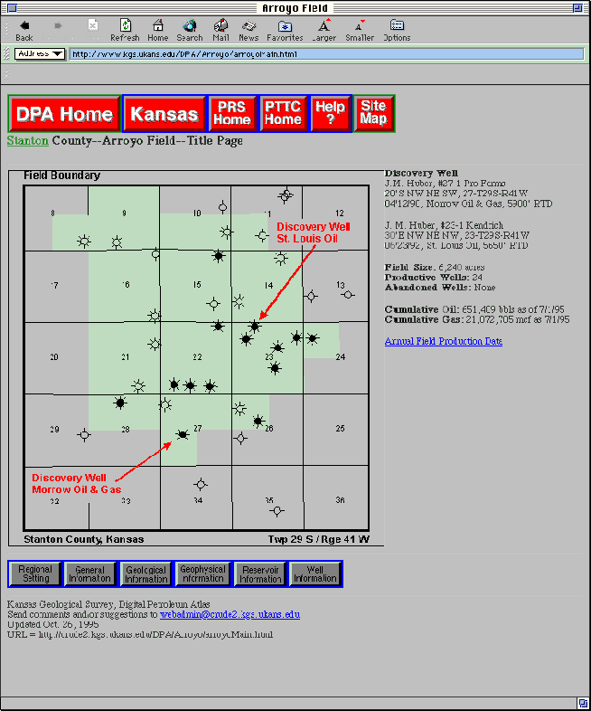
Each field study homepage provides a map of the field area, basic field and discovery information, and a standardized set of links to additional geologic, geophysical, engineering and production data (Figure 10, http://www.kgs.ku.edu/DPA/Arroyo/arroyoMain.html).
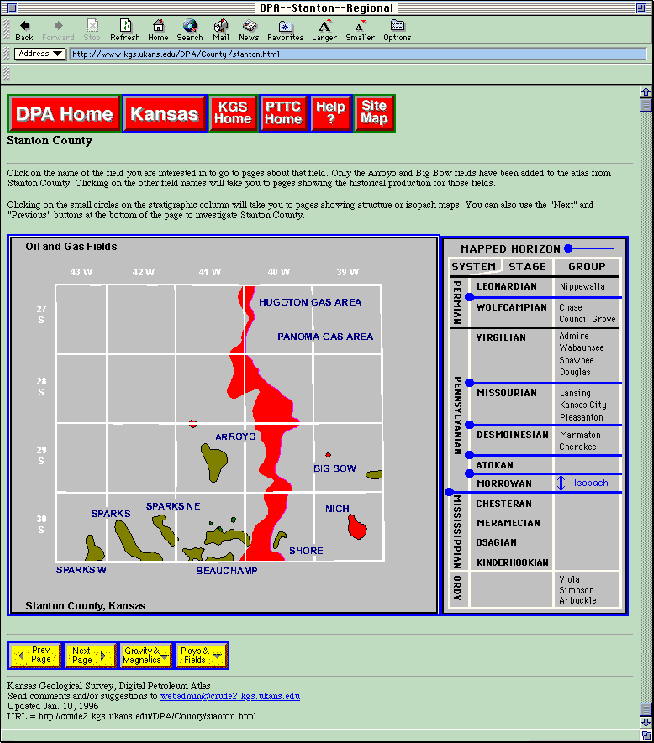
Figure 9. County map and geologic column for Stanton County, Kansas (http://www.kgs.ku.edu/DPA/County/stanton.html). Both the geologic column and the county map are graphical user interfaces that can access additional geologic and petroleum information. Ia addition buttons below mp can be used to access additional information.
Figure 10. Field home page for Arroyo Field in Stanton County, Kansas. (http://www.kgs.ku.edu/DPA/Arroyo/arroyoMain.html). Page can be accessed directly using the DPA site map, by searching on field parameters or by clicking on the Arroyo Field name on the Stanton County HomePage (Figure 9) The links on the field homepage provide access to pages containing geologic, geophysical, engineering, production and well information.
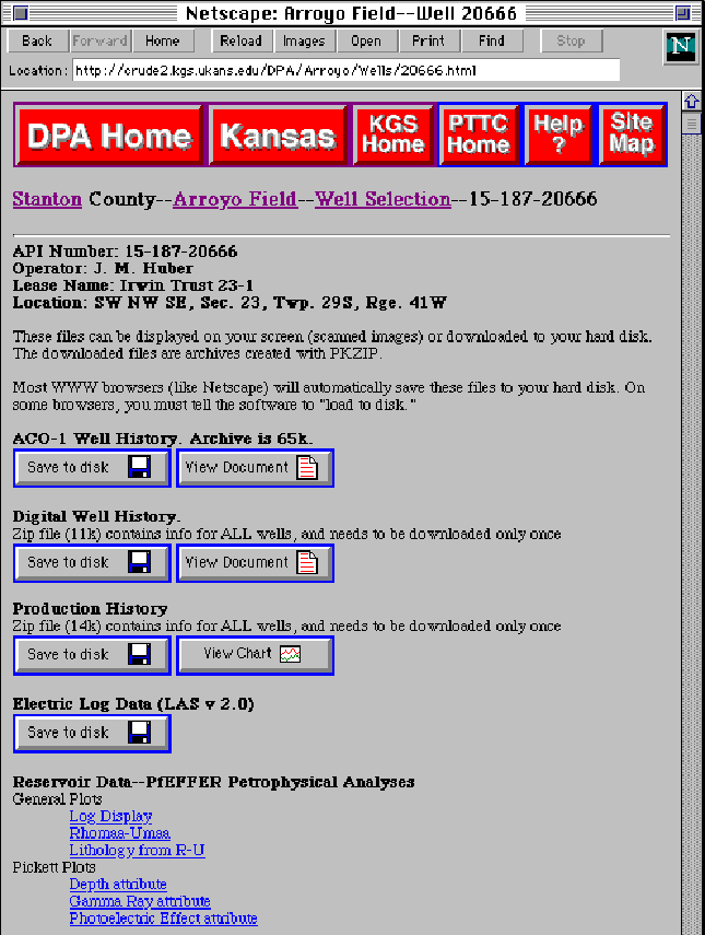
Figure 11. Individual well data page for a selected well in the Arroyo Field, Stanton County, Kansas (http://www.kgs.ku.edu/DPA/Arroyo/Wells/20666.html). Data includes a raster image of the original completion report (ACO-1), digital well data (including geologic mapping horizons), production data, electric log data (LAS format), and other reservoir data associated with the individual well. Well data can be accessed by clicking on the well spot on the field map, by searching on API number, or through a township-range-section search.
Using the Arroyo Field in Stanton County Kansas as an example, the links for each homepage are:
Navigation among the Digital Petroleum Atlas web pages is provided by a suite of standardized buttons that provide hypertext links or through search engines. The navigational tools permit the user to move through the DPA in a more or less linear path, similar to a traditional book, or to skip rapidly among related subjects and scales.
As with all World-Wide-Web pages, text that is blue and underlined provides links to other pages. Some links are to other pages in the DPA, some are to other pages on the world-wide-web server at the Kansas Geological Survey, and a few may lead to servers outside the Kansas Geological Survey. At the top and bottom of DPA web pages is a standardized suite of navigational buttons that provide hypertext links to various critical DPA web pages. The top navigation bar should appear in red (Figure 12). It contains the following set of navigation buttons to move the user among the major DPA components and to other petroleum related research units at the University of Kansas.
DPA Home: Link to the homepage for the Digital Petroleum Atlas Project (http://www.kgs.ku.edu/DPA/dpaHome.html). The Homepage for the Digital Petroleum Atlas Project contains an additional navigation button in blue that provides a direct link to the US Department of Energy homepage (http://apollo.osti.gov/html/home.html).
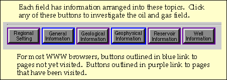
A navigation bar located on each field-level homepage
provide links to standardized topical areas (figures 10, and 13a).
The topical areas covered include:
In addition to the navigation bar for topical areas, buttons on the bottom of selected regional, county and field homepages provide the user the ability to move stepwise through the material. A set of ìnext page / previous pageî buttons provides a more-or-less linear book-like approach to navigating through DPA material (Figure 13b).
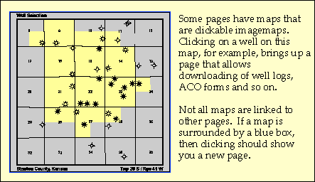
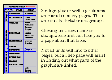
Clickable interactive image maps and figures occur throughout the DPA (Figure 14). These graphical user interfaces are surrounded by a blue box and provide active links to custom maps and plots and to access additional DPA pages. Examples include the interactive map on the Well Information Page under each field study (Figure 14a). Clicking on a well spot on this image map provides access to the well page for that particular well (e.g., Figure 11). Another example is the interactive stratigraphic column on each County Page (figures 9, and 14b). By clicking on each active stratigraphic horizon, the column provides access to geologic and geophysical maps. Similar interactive image maps and figures occur throughout the DPA and provide links to maps, cross-sections, production plots, figures, and a wide variety of information and interpretative material.
Fields and wells in the DPA can be searched by geographic location (Section-Township-Range), name (API number or field name) and in the case of fields by a flexible search routine that incorporates production and geologic parameters. The search for wells and fields can be accessed through a navigation bar the appears on the Kansas DPA Homepage (figures 13c and 6, http://www.kgs.ku.edu/DPA/dpaKansas.html). Similar buttons to access search programs are available on the county and field pages.
Several search routines written in C permit search by county, section-township-range, or API number of individual well data (e.g., logs, completion reports, production, etc.). All wells used in the DPA are accessible through on-line search routines. Fields in Kansas can be retrieved using a similar set of input panels and C programs (Figure 15, http://www.kgs.ku.edu/DPA/Forms/GeneralInfo.html). Parameters such as geographic location, producing horizon, discovery date, cumulative production, reservoir lithology, trap type, etc., can be used to sort and search the 6,000+/- Kansas oil and gas fields. Field studies that are part of the DPA are returned as active links that can be used to access additional information.
The search panel and programs are the basis of searches at the play, field, reservoir and well levels, and provides the engine for flexible searching based on user selected geologic and production criteria through the thousands of fields, reservoirs or wells.
While a researcher new to Kansas may find the maps and charts are the most efficient way to become familiar with the data available on-line, the experienced user can use the search engines to locate answers to specific production and exploration questions. Work in progress will replace the existing C programs with powerful database software (ORACLE). Replacing the custom-written programs will provide greater flexibility to the user and reduce maintaenance of the DPA.

Figure 12. Navigation bar located at the top of most pages in the DPA. The bar provides hypertext links to the major components of the digital atlas.
 a.
a.
 b.
b.
 c.
c.
Figure 13. a.) Navigation bar located at bottom of field pages in the DPA. Buttons lead to the topical areas covered for each field study (e.g. Geological Information). b.) Additional navigation bar located at bottom provides additional links among multiple web pages within a topical area. c.) Navigation bar that appears on selected regional, county and field homepages that provides links to search engines for locating wells and fields (See Figure 15 for an example).
 a.
a.
 b.
b.
Figure 14. a.) Interactive image map provides access to pages by clicking on objects such as well spots. Clicking on well spot will lead to well information and downloadable data about that well. b.) Clicking on an interactive image such as a stratigraphic column will provide a new image (e.g., a structure map).
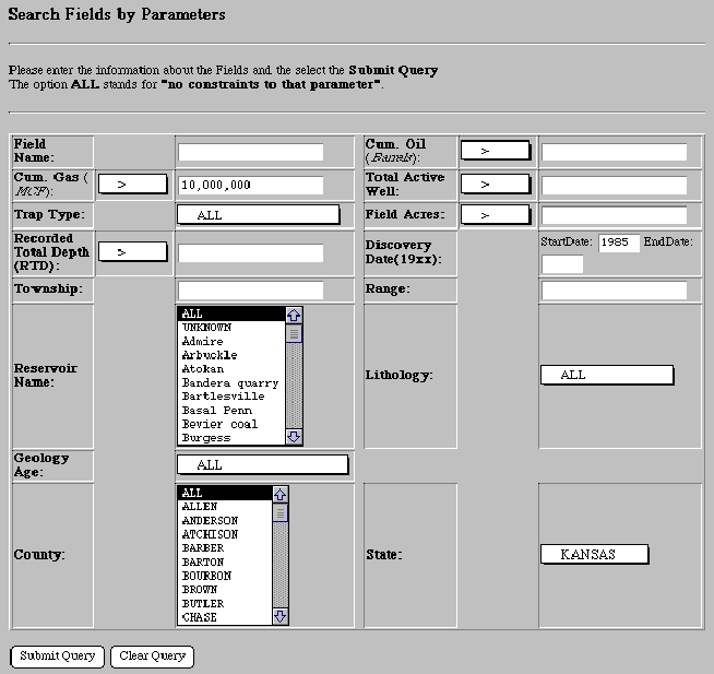
Figure 15. Input panel for searching for oil and gas fields by selected parameters (http://www.kgs.ku.edu/DPA/Forms/GeneralInfo.html). This example searches for gas fields discovered in Kansas after 1985 that have cumulative production of more than 10 Bcf. The search returned basic information about four fields including Arroyo Field in Stanton County, Kansas. Arroyo Field, which is part of the prototype DPA, is an active link that provides access to the detailed DPA field study. Searches can be conducted by a number of other geologic and geographic parameters. Also algebraic operators can be modified. Similar panels can be used for single well searches.
The world-wide-web and the publish as-you-go design of the
prototype Digital Petroleum Atlas Project provided immediate and
ongoing technology transfer activities. The DPA model appears to
provide an efficient method of technology transfer to the
geographically dispersed high technology petroleum industry. The
pages that comprise the DPA are among the most visited on the Kansas
Geological Survey web site and usage continues to grow (Figure 2,
http://www.kgs.ku.edu/PRS/usage/
past_stats.html). Periodic email updates provided to interested
operators and individuals have been well
received. The distribution of the email update continues to grow and
currently reaches 40 companies, organizations and individuals. As
part of technology transfer efforts, seven formal talks and papers
were presented to local and national meetings (Table 2). A paper to
be published in COMPUTERS AND GEOSCIENCE uses the Digital Petroleum
Atlas as a primary example of new forms of on-line publication (Carr
and others, in press). A copy of this manuscript is available on-line
as DPA topical report
(http://www.kgs.ku.edu/PRS/publication/OFR96_37/abstract.html).
A paper on the application of the Internet for providing natural
resource information and technology is to be published in the
PROCEDDINGS OF THE GEOSCIENCE INFORAMTION SOCIETY (Carr and others,
in press)
Table 2.-- Formal presentations that resulted from the first year
of the Prototype Digital Petroleum Atlas Project. Selected abstracts
are included in Appendix A.
In addition to verbal feedback, a number of email comments were
received from oil and gas operators that indicate that the product is
meeting a need. Included are selected email comments from operators
(names and affiliations removed).
"The digital petroleum atlas is one of the few worthwhile petroleum sites on the internet. You are demonstrating what can be done with the Web. We need more states to start doing what you are doing. Until we see more products like this the small independent will not be on the internet."
"I think the Kansas O&G database is great and wish the project much success. I wanted to know when monthly well and field data would be available. Also will injection data also reside in the database eventually? Have you thought about writing Java applets that would plot data various ways and do decline analysis."
"I really like the direction you're taking with the Digital Petroleum Atlas. This is the kind of information I've been hoping for from KGS and PTTC. Can't wait for you to start on other counties (like Lane and Ness for example hint, hint). Keep up the great work."
"This service is very useful and saves a great deal of time."
"You have done an excellent job! Love the feature, keep up the good work."
The Digital Petroleum Atlas was designed to be a dynamic product with the constant addition of new information and ideas. Within this changing environment all defined tasks of the one-year prototype DPA were completed. The only significant modification is elimination of a widely distributed CD-ROM version of the DPA. The growth of the Internet and the power and dynamic nature of the web format does not justify a published CD-ROM version. However, a modified CD-ROM version can be easily produced on request. In using the DPA, oil and gas operators and the interested public propose many of the ongoing changes and additions. The prototype DPA project was completed within budget and cost sharing was in excess of 20%.
Results from the one-year prototype Digital Petroleum Atlas Project have significantly exceeded expectations. A follow-up project was proposed to expand the breath of plays, fields and reservoirs covered, enhance the included petroleum technology, expand the geographic coverage beyond Kansas, and improve the navigation and search technology for access to DPA technology and information.
As the first year of a longer-term effort, the prototype Digital
Petroleum Atlas (DPA) has developed a new methodology to provide
efficient and timely access to the latest petroleum data and
technology for the domestic oil and gas industry, public sector
research organizations and local governmental units. The DPA provides
real-time and cost-effective electronic publication of materials
typically found in published paper oil and gas atlases. The latest
technologies and information are continously ìpublishedî
electronically when individual project components are completed,
removing the lag and expense of transferring technology using
traditional paper publication. Additional information and technology
are constantly being added to the DPA to increase the scope and
detail. Active links, graphical user interfaces and database search
mechanisms provide a published product with which the operator can
interact in ways that are impossible in a paper publication.
Contained in the DPA are forms of publication that can only be
displayed in an electronic environment (for example, animated
exploration histories through time). Improvement in data and
technology access for the domestic petroleum industry represents one
of the best and cost-effective options that is available for
mitigating the continued decline in domestic production.
The one-year prototype DPA Project developed methodologies and
computerized procedures to study, compile and ìpublishî
a limited set of field and play studies concentrated in Kansas and to
a lesser extent the Northern Mid-continent Region. As part of the one
year DPA project, three Kansas field studies were completed (Arroyo,
Gentzler and Big Bow).
Through complete and flexible user access to technology, interpretative products and the underlying geologic and petroleum data, the DPA changes the relationship between interpretative result and data, between technology generation and application.
Beaumont, E. A., and N. H. Foster (compilers), 1990, Stratigraphic
Traps I, Treatise of Petroleum Geology, Atlas of Oil and Gas Fields,
American Association Petroleum Geologists, Tulsa, OK, 295 p.
Bebout, D. G., W. A. White, T. F. Hentz, and M. K. Grasmick
(editors), 1993, Atlas of Midcontinent Gas Reservoirs; Bureau of
Economic Geology, The University of Texas at Austin, Austin, Texas,
85 p.
Carr, Timothy R., Rex C. Buchanan, Dana Adkins-Heljeson, Thomas D.
Mettille, and Janice Sorensen, in press, The Future of Scientific
Communication in the Earth Sciences: The Impact of the Internet;
Computers and Geoscience, June 1997 issue.
http://www.kgs.ku.edu/PRS/publication/OFR96_37/abstract.html
Carr, Timothy R., Dana Adkins-Heljeson, Rex C. Buchanan, Janice
Sorensen, and Thomas D. Mettille, in press, The impact of the
Internet on the public sector: providing natural resource information
and technology to Kansas; Geoscience Information Society Proceedings,
v27.
Claerbout, Jon, 1994, Seventeen years of super computing and other
problems in seismology, text of talk at National Research Council
meeting on High Performance Computing in Seismology, 2 October;
http://sepwww.stanford.edu/sep/jon/nrc.html.
Denning, Peter J. and Bernard Rous, 1995, The ACM electronic
publishing plan; ACM, Inc.;
http://www.acm.org/pubs/epub_plan.html.
Galloway, W. E., T. E. Ewing, C. M. Garrett, N. Tyler and D. G.
Bebout (editors), 1983, Atlas of Major Texas Oil Reservoirs; Bureau
of Economic Geology, The University of Texas at Austin, Austin,
Texas, 139 p.
Foster, N. H. and E. A. Beaumont (compilers), 1991, Stratigraphic
Traps II, Treatise of Petroleum Geology, Atlas of Oil and Gas Fields;
American Association Petroleum Geologists, Tulsa, OK, 360 p.
Foster, N. H. and E. A. Beaumont (compilers), 1992, Stratigraphic
Traps III; Treatise of Petroleum Geology, Atlas of Oil and Gas
Fields; American Association Petroleum Geologists, Tulsa, OK, 445
p.
Halbouty, M. T. (editor), 1981, Giant oil and gas fields of the
decade, 1968-1978; American Association Petroleum Geologists Memoir
30, Tulsa, OK, 596 p.
Kerkhof, B. M., 1994, Journal publishing and the (electronic)
future: Expectation challenges and reality, in, C. Wick (ed.),
Finding and Communicating Geoscience Information; Proceedings of the
Twenty-Eighth Meeting of the Geoscience Information Society, p.
11-19.
Okerson, Ann, 1992, Synopsis, in, A. M. Cummings and others
(eds.), University Libraries and Scholarly Communication: A Study for
the Andrew W. Mellon Foundation by the Association of Research
Libraries, p. xv-xxiv,
gopher://gopher.lib.virginia.edu:70/00/alpha/mellon/synopsis.txt.
Powers, S. (editor), 1929, Structure of Typical American Fields: A
symposium on the relation of oil accumulation to structure (3 vols.)
; American Association Petroleum Geologists, Tulsa, OK, 1806 p.
Robertson, J. M., R. F. Broadhead, A. W. Goody, and C. A.
Hjellming (editors), 1993, Atlas of Major Rocky Mountain Gas
Reservoirs; New Mexico Bureau of Mines and Mineral Resources,
Socorro, NM, 206 p.
U. S. Geological Survey, 1995, National Assessment of United States Oil and Gas Resources; U. S. Geological Survey, Digital Data Series DDS-30, Release 2, CD-ROM.
Paper presented at the Society of
Independent Petroleum Earth Scientists (SIPES), Dallas, Texas,
3/21/96
The Role of the Public Sector in Providing Cost-Effective
Technology to the Petroleum Independent: A Kansas Example
CARR, TIMOTHY R., Kansas Geological Survey, University of Kansas,
Lawrence, KS
To remain competitive, independent oil operators require the highest level of appropriate technology, and the highest quality data. Major technical challenges to independent operators are; geologic and engineering uncertainty, lack of knowledge of existing technology, lack of high quality data, and the lack of confidence that existing technologies can improve operations. In the last few years, the University of Kansas and the Kansas Geological Survey have attempted to address these technical challenges by a renewed commitment to improve technology and data transfer. Improvements include changes both in organizational structure, research directions, and in the process of technology transfer.
Research efforts in Kansas have focused on developing tools that leverage existing data through cost-effective application of technology. Examples include: use of well logs within interpretation systems designed for analysis of 3D seismic data ("Pseudoseismic"); a spreadsheet computer program to implement traditional and innovative log analysis (PfEFFER); and techniques for acquisition of high-resolution seismic data.
Changes in the technology transfer process are moving away from
the one-on-one consultations, paper publications and dusty files, and
toward providing high-speed large-volume conduits for digital data
and technology among operating companies, service companies,
consultants and public sector entities. The Internet has provided
just-in-time accessibility to fundamental well, reservoir, and
geographic data (such as e-logs, production volumes, and digital map
data), to petroleum related data compilations (such as field studies,
regional maps and bibliographies), and to the latest research ideas.
The virtual resource center provides a flexible and efficient method
to disseminate data and technology to a geographically dispersed high
technology industry.
Paper presented at Kansas Independent
Oil and Gas Association (KIOGA), Wichita, Kansas, 8/26/96
The Internet: A Tool to Access Information and Technology for
the Petroleum Independent in Kansas
CARR, TIMOTHY R., Kansas Geological Survey, University of Kansas,
Lawrence, KS
The exchange of information and research results in the petroleum industry is moving away from the one-on-one consultations, paper publications and dusty files. Budget constraints and changes in communications have opened high-speed, large-volume conduits for digital data and technology among operating companies, service companies, consultants and public sector entities. The Internet provides the petroleum independent with just-in-time accessibility to real-time data (such as oil and gas prices), and basic exploration and development data (such as e-logs, production volumes, and digital map data). In addition the independent can search and access petroleum related data compilations (such as field studies, regional maps and bibliographies), and the latest research ideas.
The Kansas Geological Survey and the KU Energy Research Center are working with Kansas operators and organizations to construct a virtual resource center that provides a flexible and efficient method to communicate data and technology to a geographically dispersed high technology industry.
Paper presented at the Geological
Society of America, Denver, Colorado, 10/28/96
The Impact of the Internet on the Public Sector: Providing
Natural Resource Information and Technology to Kansas
CARR, Timothy R., tcarr@kgs.ku.edu; ADKINS-HELJESON,
Dana, dana@kgs.ku.edu; BUCHANAN, Rex C.,
rex@kgs.ku.edu; Thomas D. METTILLE; Kansas Geological Survey, University
of Kansas, Lawrence, KS
The Kansas Geological Survey uses the Internet as an important communication channel. The Internet provides rapid, cost-effective access to natural resource data, informational sources, publications, and technology. Usage of the Surveyís web server has grown dramatically. Today, the Survey is weaving the Internet into all of its ongoing and future research and public service operations.
Technology and information transfer processes are moving away from individual consultations, paper publications, and dusty files, and toward high-speed large-volume conduits for digital data and technology that better fit the wide audience of academic organizations, private and public sector entities, and individual citizens. The Internet provides flexible just-in-time accessibility to fundamental geologic and geographic data, to data compilations, and to the latest research and technical studies. Products are available on-line as they are completed, at a fraction of the time and cost of paper publication. Publications with relational links and search engines allow users to modify the scale and focus to their particular requirements, and permit access to data in a compatible format for validation and risk analysis. The Survey is designing research and technical products that go beyond traditional publications and take advantage of the Internet capabilities (examples include the Digital Petroleum Atlas and the Kansas GIS Core Database).
The Surveyís virtual resource center provides a flexible
and efficient method to disseminate data and technology, and provide
geologic research to a geographically dispersed population. The
Internet better enables the Surveyís information and research
results to serve as the framework upon which individual and public
policy decisions are built.
Scientific Communication in the Earth Sciences: The Impact of the Electronic Publication
TIMOTHY R. CARR; DANA ADKINS-HELJESON; REX C. BUCHANAN; PAUL GERLACH; THOMAS D. METTILLE; and JANICE H. SORENSEN; Kansas Geological Survey, University of Kansas, Lawrence, KS
Traditional paper media, such as books,
monographs, journals, and maps. have been a recognizable aspect of
geologic work for several centuries. They remain the primary medium
for communicating research results, transferring technology, and
archiving knowledge. However, continued growth in volume of
earth-science literature, increased unit costs of producing and
archiving paper publications, and rapidly increasing power and
availability of electronic technology are creating pressures on
traditional scientific communication, and rapidly altering the role
of traditional publication as a means of scientific communication.
Electronic publication provides broad access and alters the
relationship between interpretative result and the data. Electronic
technology improves the quality and accessibility of
ìnon-traditionalî research products, (e.g., digital
geographic information and unpublished archival material), and
provides the means to create dynamic forms of scientific
communication that can only be displayed in an electronic
environment. New forms of communication use hypertext and relational
database functions to provide text and graphics with which readers
can interact. Electronic publication improves research
reproducibility and facilitates use and continued enhancement of
research products. Earth science institutions, including the Kansas
Geological Survey, are experimenting with new forms of on-line
publication that assure broad access to research and data, and
improve application of research to societal problems.
To be presented at Powder River Basin
Section of Society of Petroleum Engineers, Gillette, Wyoming,
5/14/97
The Internet: A Tool to Access Information and Technology for
the Petroleum Independent
CARR, TIMOTHY R., Kansas Geological Survey, University of Kansas,
Lawrence, KS 66047-3726
The exchange of information and research results in the petroleum industry is moving away from the one-on-one consultations, paper publications and dusty files. Budget constraints and changes in communications have opened high-speed, large-volume conduits for digital data and technology among operating companies, service companies, consultants and public sector entities. The Internet provides the petroleum independent with just-in-time accessibility to real-time data (such as oil and gas prices), basic exploration, development and production information (such as e-logs, production volumes, and digital map data). In addition, the independent can search and access petroleum related compilations (such as field studies, regional maps and bibliographies), and the latest research ideas.
The Kansas Geological Survey and the University of Kansas Energy Research Center are working to construct a working national model of a virtual resource center. An on-line resource that provides flexible and efficient communication of data and technology to a geographically dispersed high technology industry.