


|


|
Play: Early Ordovician/Cambrian Arbuckle
Basin: Central Kansas Uplift
Counties: Rice, Barton, and Stafford Counties
Chase-Silica Field
You can explore the Chase-Silica Field by clicking on the blue topic buttons
to the left.
Use the Field Site Map to learn what resources are available
for the Chase-Silica Field.
|

|
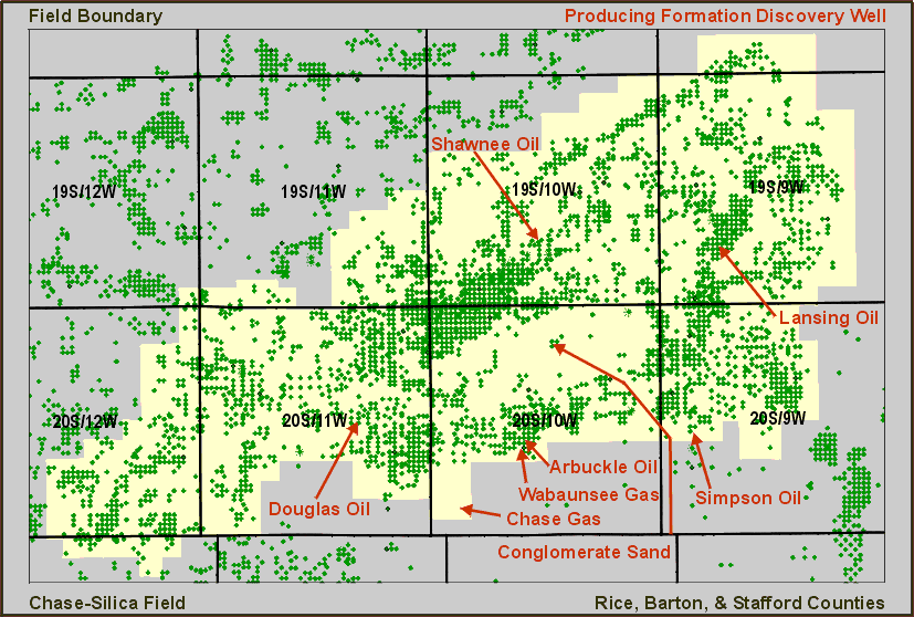
Discovery Well
Producers & Refiners, # 1 Thompson, SE SE NW, 21-T20S-R10W, 02/07/30,
Arbuckle Oil
Keith, #1 Grove, SE SE NW, 29-T19S-9W, 06/13/34, Lansing Oil
Holland, #1 Malone, NE SW NE, 19-T20S-T9W, 04/04/38, Simpson Oil
Skelly, #1 Smith, S2 SE NE, 28-T19S-R10W,06/08/45, Shawnee Oil
Huber, #1 Schurr, SE NE SW, 21-T20S-R10W, 12/07/48, Wabaunsee Gas
NCRA, #7 Langfield, N2 SW SW, 14-T20S-R11W, 05/06/55, Douglas Oil
M & H, #1 Keesling, SE SW SW, 3-T20S-R10W, 01/02/56, Conglomerate Oil
Mapco, #1 Balden, NE, 31-T20S-R10W, 09/04/74, Chase Gas
Field Size: 98,560 acres
Total Wells: 4,393
Productive Wells: 2,192
Abandoned Wells: 2,201
Cumulative Oil: 308,937,717 bbls as of 10/31/97
Current Average Monthly Oil: 52,420 bbls as of 10/31/97
Cumulative Gas: 7,755,056 mcf as of 10/31/97
Current Average Monthly Gas: 13,794 mcf as of 10/31/97
Annual Field Production Data
Kansas Geological Survey, Digital Petroleum Atlas
Comments to webadmin@kgs.ku.edu
Updated June 29, 1998
URL = http://www.kgs.ku.edu/DPA/Chase/chaseMain.html