Kansas Geological Survey, Current Research in Earth Sciences, Bulletin 258, part 4
Prev Page--Start || Next Page--Previous studies, Howe Limestone Member
![]()
![]()
![]()
Kansas Geological Survey, Current Research in Earth Sciences, Bulletin 258, part 4
Prev Page--Start ||
Next Page--Previous studies, Howe Limestone Member
![]()
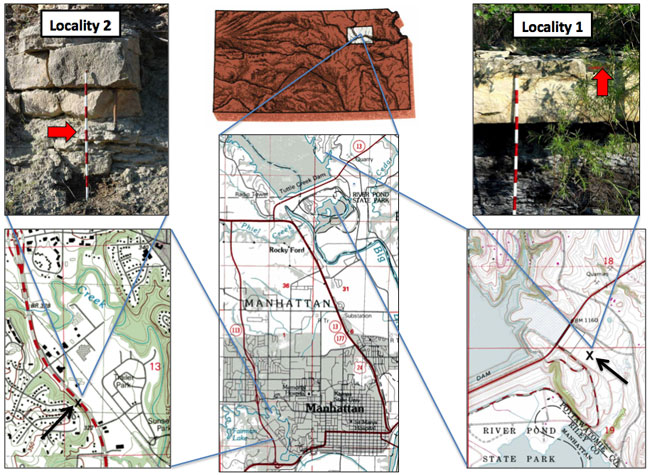
The Howe Limestone Member of the Red Eagle Limestone (Council Grove Group) of Kansas is the first named limestone unit above the recently designated conodont-based Carboniferous (Pennsylvanian)-Permian boundary in the North American midcontinent (Sawin et al., 2006; figs. 1 and 2). No fusulinids have been previously described from the Howe Limestone Member. Fusulinids are widely used index fossils for late Paleozoic marine strata, and so the Howe fusulinid fauna is significant for the definition and correlation of the new systemic boundary throughout North America. Fusulinid assemblages from two Howe Limestone Member localities in northeastern Kansas (fig. 1) are discussed in this study.
Figure 1--Maps and photographs of the two Howe Limestone Member fusulinid sample localities discussed herein. The solid red arrows in the outcrop photographs point to the horizons where the fusulinid samples were collected. North in all maps is toward the top of the page.
The conodont-based Carboniferous (Pennsylvanian)-Permian Global Stratotype Section and Point (GSSP) was designated in the southern Ural Mountains of Kazakhstan (Davydov et al., 1991) and was correlated with conodonts in midcontinent North America by Ritter (1995) and Chernykh and Ritter (1997). That conodont-based correlation shifted the traditional North American midcontinent systemic boundary from the base of the Admire Group upsection to the contact of the Glenrock Limestone and Bennett Shale Members of the Red Eagle Limestone in the lower part of the Council Grove Group (fig. 2).
Figure 2--Fusulinid species range chart, lithostratigraphy, and cyclothemic depositional sequences for Admire, Council Grove, and lower part of the Chase Groups in Kansas. To the right of the lithostratigraphic column is a generalized sea-level curve, showing red beds (thick red lines) and coal beds (thick black lines). To the right of the sea-level curve, vertical red and blue lines represent individual 4th order sequences. Solid red arrows indicate 3rd order sequence boundaries, based on Boardman et al. (2009). HST means highstand systems tract, and TST means transgressive systems tract, and those system tracts are labeled only for the 3rd order cycles. The recently conodont-based midcontinent Carboniferous (Pennsylvanian)-Permian boundary at the Glenrock limestone-Bennett shale contact (Red Eagle Limestone, lower part of the Council Grove Group) is marked by a solid red line across the chart. Stratigraphic positions of global stage boundaries (Gzhelian, Asselian, Sakmarian, Artinskian) are based on conodont biostratigraphic correlations by Boardman et al. (2009). The Asselian/Sakmarian and Sakmarian/Artinskian GSSP's have not been established internationally or in Kansas (International Commission on Stratigraphy, 2009; Sawin et al., 2008).
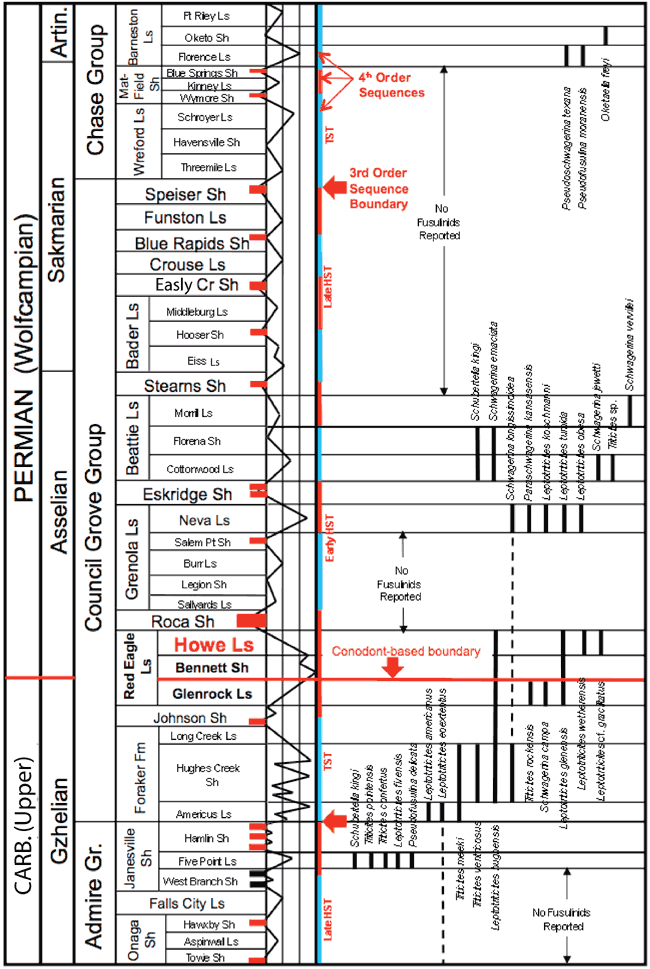
During most of the 20th century, the Carboniferous (Pennsylvanian)-Permian boundary in the North American midcontinent was placed at a regional unconformity between the Wabaunsee and Admire Groups (Moore, 1940; fig. 2). As a result, fusulinids (e.g., Thompson, 1954) and other fossil assemblages from the Admire Group and overlying lower part of the Council Grove Group, and correlative units throughout North America, were dated as earliest Permian (early Wolfcampian). Ross (1963, fig. 11), in a study of the fusulinids of the Wolfcampian stratotype in the Glass Mountains of west Texas, recognized that the North American boundary horizon did not correlate well biostratigraphically with the Eurasian Carboniferous-Permian boundary. Ross (1963, fig. 11) suggested that in North America the Carboniferous (Pennsylvanian)-Permian boundary could be placed slightly higher in the section at the base of the zone of inflated schwagerinids (Pseudoschwagerina, Paraschwagerina), which is at the base of the Neal Ranch Formation in the Wolfcampian stratotype. Ross and Ross (1987a,b) proposed two new Wolfcampian substages in the stratotype, the Nealian and Lenoxian, based on the Neal Ranch and overlying Lenox Hills Formations, both of which are unconformity-bound units.
Davydov et al. (1991, 1992) proposed to the International Stratigraphic Subcommission that the base of the Permian System in type-Eurasian region be designated at the base of the Asselian Stage in the southern Ural Mountains of Kazakhstan based on the appearance of the conodont Streptognathodus isolatus and on the slightly higher appearance of the first inflated schwagerinid fusulinids (Sphaeroschwagerina). Citing that proposal, Baars et al. (1994) proposed that the Carboniferous (Pennsylvanian)-Permian boundary in the North American midcontinent be elevated from the traditional Wabaunsee-Admire Group boundary to the Neva Limestone Member of the Grenola Limestone (middle part of the Council Grove Group) in Kansas, where the first North American inflated schwagerinid Paraschwagerina kansasensis (Beede and Kniker) appears. Then, Ritter (1995) and Chernykh and Ritter (1997) correlated the conodont faunas from the proposed Uralian boundary stratotype with those of midcontinent North America to a slightly lower horizon at the contact of the Glenrock Limestone and Bennett Shale Members of the Red Eagle Limestone (lower part of the Council Grove Group; fig. 2). A few years later, the International Stratigraphic Subcommission approved the definition of the base of the Asselian Stage at the first occurrence of Streptognathodus isolatus and the proposal of a new Global Carboniferous (Pennsylvanian)-Permian Boundary Stratotype Section (GSSP) in the southern Ural Mountains of Kazakhstan (Davydov et al., 1998). Boardman et al. (1998) recognized that horizon in Kansas at the Glenrock Limestone-Bennett Shale Members contact. Sawin et al. (2006) proposed the Red Eagle Limestone section at the Tuttle Creek Lake Spillway in Kansas (Locality 1 herein) as the North American boundary reference section. Wahlman (1998), Wahlman and King (2002), Wahlman and Kues (2004), and Wahlman (in prep.) have most recently discussed the fusulinid biostratigraphy of the new Carboniferous (Pennsylvanian)-Permian boundary interval in the midcontinent and southwestern United States, noting that further analyses of fusulinid faunas between the new boundary and the Neva Limestone Member of the Grenola Limestone in the midcontinent are needed.
Prev Page--Start || Next Page--Previous studies, Howe Limestone Member
Kansas Geological Survey
Placed online Dec. 3, 2010; Revised Jan. 2011
http://www.kgs.ku.edu/Current/2010/Wahlman/02_intro.html
email:webadmin@kgs.ku.edu