Kansas Geological Survey, Current Research in Earth Sciences, Bulletin 250, part 2
Prev Page--Characteristics || Next Page--References
![]()
![]()
![]()
Kansas Geological Survey, Current Research in Earth Sciences, Bulletin 250, part 2
Prev Page--Characteristics ||
Next Page--References
![]()
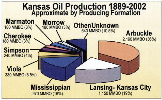
Since the 1910's, several billion barrels of oil have been produced from the Central Kansas uplift (CKU), primarily from carbonate reservoirs within the Arbuckle and Lansing-Kansas City (Pennsylvanian) Groups. The Arbuckle fields of central Kansas followed closely on the heels of the Arbuckle discovery in 1917 at El Dorado field in Butler County, Kansas, and these Arbuckle fields represent the first oil production in the western ranges of Kansas. The majority of these Arbuckle reservoirs of central Kansas were drilled prior to 1955 and constitute a series of giant and near-giant oil fields (fig. 23). The significance of the Arbuckle to Kansas production and reserves is highlighted by the estimate that Arbuckle reservoirs have produced about 2.19 billion barrels of oil (BBO) representing approximately 36% of the 6.1 BBO of total Kansas oil production to date (fig. 24).
Figure 23--Plot of number of Arbuckle field discoveries by year. Almost 50% of Arbuckle fields were discovered by 1955, which closely coincides with the peak year of discovery (1953). Subsequent secondary discovery peaks occurred in the late 1960's and mid-1980's and can be attributed to new technology and commodity prices.
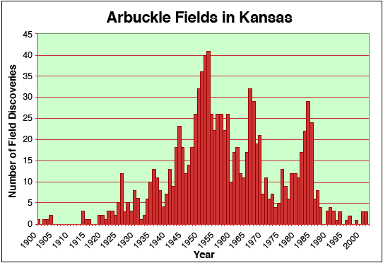
Figure 24--Arbuckle reservoirs have produced 2.19 billion barrels of oil (BBO) representing 36% of the 6.1 BBO of total Kansas oil production.
Structure has played a major role in the development of Arbuckle reservoirs on several different scales. On a statewide scale, most major hydrocarbon production within the Arbuckle in Kansas occurs on two major uplift features, the CKU and the Nemaha uplift (fig. 25), with the Arbuckle Group being the most significant pay zone on the CKU (Newell et al., 1987). Most productive fields on the CKU are structural and structural-stratigraphic traps that produce oil or gas from the top of the Arbuckle section (Walters, 1958). On a more local scale, the El Dorado field in Butler County is associated with several large-scale fault-bounded domes. As an example of structural influence on a still smaller scale, high-volume production within the West Shumway dome in the El Dorado field follows what appear to be original tectonic fracture systems with north-south and east-west orientations (Ramondetta, 1990).
Figure 25--A) Structure map (subsea elevation) on Arbuckle showing locations of Arbuckle production in Kansas (black). Note most production is associated with structural highs, especially the Central Kansas uplift (CKU), with other major areas of production coming from the Nemaha uplift and in the southeast. B) Arbuckle cumulative oil production (MMBO) by county. Of the 31 counties in which the Arbuckle has been productive, over 70% of the production has come from the 10-county area coinciding with the CKU.
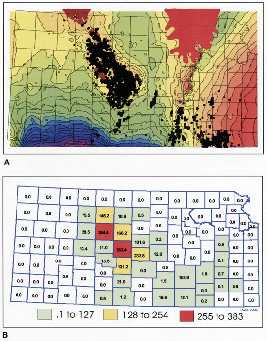
Arbuckle reservoirs produce from 31 counties statewide with a significant portion of the total production coming from the 10 counties in the CKU region (fig. 25). Within the 10-county area on the CKU, the Arbuckle has produced over 1,630 MBO, representing 69% of the production from the top four producing intervals in this region (fig. 26). Table 1 lists the 21 most productive Arbuckle fields and the cumulative oil production attributed to each. These fields represent approximately 56% of all Arbuckle production with 19 of the fields lying on the CKU and the remaining two on the Nemaha uplift in Butler and Cowley counties.
Figure 26--The Arbuckle has produced over 1,629 MBO in the 10-county area on the Central Kansas uplift, which represents 69% of the production from the top four producing intervals in this region.
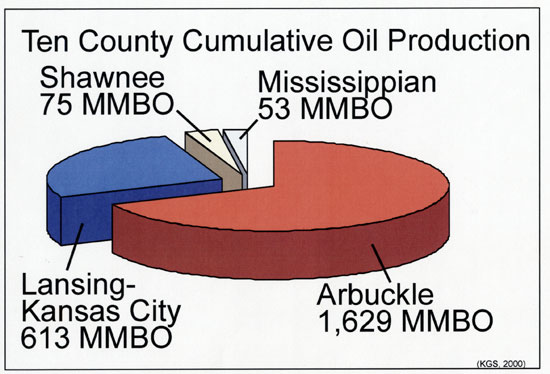
Table 1--Twenty-one major Arbuckle fields.
| Field Name | Cumulative Oil (bbl) |
Active Wells |
Twn-Rng | County | Approx. Depth (ft) |
|---|---|---|---|---|---|
| CHASE-SILICA | 307,571,872 | 876 | 18S-10W | BARTON/RICE/STAFFORD | 3,328 |
| TRAPP | 300,087,115 | 726 | 15S-14W | BARTON/RUSSELL | 3,252 |
| EL DORADO | 299,365,153 | 618 | 25S-5E | BUTLER | 2,550 |
| BEMIS-SHUTTS | 248,694,147 | 2,150 | 10S-16W | ELLIS/ROOKS | 2,967 |
| HALL-GURNEY | 152,414,246 | 1,107 | 14S-13W | BARTON/RUSSELL | 3,192 |
| KRAFT-PRUSA | 130,826,618 | 700 | 15S-10W | BARTON/ELLSWORTH/RUSSELL | 2,885 |
| GORHAM | 94,783,868 | 369 | 14S-15W | RUSSELL | 3,289 |
| GENESEO-EDWARDS | 85,900,491 | 190 | 18S-8W | ELLSWORTH/RICE | 3,278 |
| FAIRPORT | 58,735,912 | 388 | 12S-15W | ELLIS/RUSSELL | 3,350 |
| BLOOMER | 55,787,569 | 244 | 17S-10W | BARTON/ELLSWORTH/RICE | 3,200 |
| STOLTENBERG | 52,996,954 | 470 | 15S-19W | BARTON/ELLSWORTH | 3,333 |
| RAY | 48,122,148 | 159 | 5S-20W | GRAHAM, NORTON, PHILLIPS, ROOKS | 3,540 |
| AUGUSTA | 47,773,725 | 111 | 28S-4E | BUTLER | 2,600 |
| MOREL | 46,765,270 | 444 | 9S-21W | GRAHAM | 3,718 |
| MARCOTTE | 41,659,245 | 221 | 9S-19W | ROOKS | 3,752 |
| VOSHELL | 36,066,429 | 22 | 20S-3W | MCPHERSON | 3,400 |
| IUKA-CARMI | 34,128,807 | 226 | 27S-13W | PRATT | 4,354 |
| COOPER | 25,486,646 | 112 | 9S-20W | GRAHAM/ROOKS | 3,216 |
| RUSSELL | 23,243,643 | 53 | 13S-14W | RUSSELL | 3,280 |
| GATES | 21,519,184 | 125 | 21S-12W | STAFFORD | 3,679 |
| TRICO | 20,959,428 | 144 | 10S-20W | ELLIS/GRAHAM/ROOKS/TREGO | 3,651 |
| RICHARDSON | 19,843,416 | 75 | 22S-11W | STAFFORD | 3,537 |
| OXFORD | 18,196,474 | 26 | 32S-2E | SUMNER | 2,890 |
| BARRY | 17,812,734 | 132 | 8S-19W | ROOKS | 3,430 |
| MUELLER | 15,950,997 | 105 | 21S-12W | STAFFORD | 3,594 |
| OTIS-ALBERT | 15,278,960 | 22 | 18S-16W | BARTON | 3,703 |
| OGALLAH | 14,805,787 | 37 | 12S-21W | TREGO | 3,961 |
| GREENWICH | 14,165,749 | 20 | 26S-2E | SEDGWICK | 3,321 |
| BOYD | 14,055,036 | 54 | 17S-13W | BARTON | 3,438 |
| MAX | 13,344,772 | 63 | 21S-11W | STAFFORD | 3,570 |
| LORRAINE | 12,666,332 | 26 | 17S-9W | ELLSWORTH | 3,200 |
| TOBIAS | 12,521,480 | 20S-9W | RICE | 3,218 | |
| SOLOMON | 12,083,711 | 86 | 11S-19W | ELLIS | 3,629 |
| IRVIN | 11,812,943 | 76 | 13S-19W | ELLIS | 3,860 |
| NORTON | 11,692,977 | 88 | 3S-23W | NORTON | 3,778 |
| DOPITA | 11,321,826 | 131 | 8S-17W | ROOKS | 3,409 |
| HITTLE | 10,542,917 | 240 | 31S-4E | COWLEY | 3,280 |
| NORTHAMPTON | 10,113,608 | 51 | 9S-20W | ROOKS | 3,803 |
| DRACH | 10,016,115 | 23 | 22S-13W | STAFFORD | 3,690 |
| TOTAL | 2,379,114,304 | 10,710 | Note: Many fields produce from multiple horizons and not all production is Arbuckle |
||
Arbuckle reservoirs historically have been viewed as fracture-controlled karstic reservoirs with porosity and permeability influenced by basement structural patterns and subaerial exposure. The weathering and secondary solution of the upper Arbuckle beds, due to subaerial exposure, are thought to have significantly enhanced porosity and permeability and created petroleum reservoirs in these strata (Walters, 1958; Merriam, 1963; Adler, 1971).
Most of the oil and gas zones in the Arbuckle are contained in the top 25 ft, some are 25-50 ft within the Arbuckle (Adler, 1971), and Arbuckle wells are characterized by high initial potential, steep decline rates, and production of large quantities of oil at high water/oil ratios. Thus, Arbuckle reservoirs typically have been visualized as an oil column on top of a strong aquifer. This conceptual model of the Arbuckle reservoir resulted in drilling and completion practices in which wells were drilled into the top of the Arbuckle with relatively shallow penetration (under 10 ft or 3 m) and completed open hole.
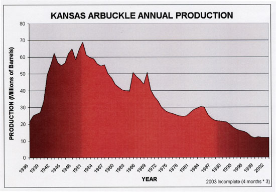
Although the Arbuckle has been a prolific producing interval since 1917, annual production peaked in the early 1950's at more than 68 million barrels and has declined to approximately 12 million barrels per year in 2002 (fig. 27). Today, stripper production dominates Arbuckle production with over 90% of wells producing less than 5 barrels of oil per day and is very sensitive to commodity prices.
Figure 27--Annual production from Kansas Arbuckle reservoirs. Peak annual production was in 1951 (68,807,787 barrels) and has declined to an estimated 12 million barrels per year. Production prior to 1936 is not available in annual increments and is not shown.
Some recent and ongoing studies on various geologic aspects of the Arbuckle Group in Kansas are beginning to provide a clearer picture of the different types of Arbuckle reservoirs, which is becoming increasingly important because the Arbuckle is currently undergoing improved oil recovery (IOR) efforts, and being considered for future CO2 floods and carbon sequestration.
The striking feature in many cores studied by Franseen (1994, 2000) and Steinhauff et al. (1998) is the abundance and apparent importance of "matrix" porosity (intercrystalline, moldic, fenestral, vuggy) throughout the entire lengths of the cores, which is related to depositional facies, early diagenesis, and dolomitization and not necessarily related to the upper post-Sauk subaerial exposure surface. The relative lack of karst-associated fracture, breccia, and dissolution porosity in most cores is especially surprising considering that the cores came from flanks or tops of structural highs where karst processes would likely have been most extensive. Observations indicate that more than 50% of the preserved porosity is "matrix" porosity. Much of the matrix porosity-rich intervals are associated with coarse-grained, laminated to bedded facies that are differentially cemented or with stromatolitic intervals that show differential porosity development likely due to differences in original texture (e.g. mud content) and early diagenesis (e.g. development of fenestral and vuggy porosity during early subaerial exposure events).
Byrnes et al. (1999) showed that the petrophysics of Arbuckle lithofacies at the core-plug scale, and for many lithologies at the whole-core scale, are dominantly controlled by grain size. Each lithology exhibits a generally unique range of petrophysical properties modified by the presence of fractures, vuggy porosity, and grain-size variation within the lithologic class. Facies comprising multiple lithologies of differing grain size exhibit bulk properties that are scale-dependent and are a function of the architecture of the constituent facies. All lithologies exhibit increasing permeability with increasing porosity and can be broadly characterized as lying along the same general porosity-permeability trend (fig. 22). Variance in permeability for any given porosity is approximately two orders of magnitude and may be primarily attributed to the influence of such lithologic variables as the ratio and distribution of matrix and fenestral/vuggy porosity, grain-size variations, and subtle mixing or interlamination of lithologies. Fracturing of lithologies enhances permeability directionally but does not add significantly to porosity (fig. 22). Vuggy porosity (even up to as high as 8%) is largely isolated in mudstones, but is better connected in wackestones. Vuggy pores can be well connected where vuggy porosity is extensive near the unconformity surface.
The dominance of matrix porosity (intercrystalline, moldic, fenestral, vuggy) related to depositional facies, early diagenesis, and dolomitization, and the control of laterally persistent stratal packages on flow properties is a departure from the perception that karst is the only control on reservoir properties, and emphasizes the importance of understanding facies distribution. For example, the packstone-grainstone and boundstone reservoir facies are much more likely to be favorable reservoirs where they intersect the unconformity as compared to where other non-reservoir facies intersect the unconformity (Franseen et al., 2003). In addition, the facies distributions in potentially laterally continuous beds of various scales may have implications for deeper reservoir zones. Deeper low- to moderate-volume stratified production has been identified in a number of fields in Kansas (e.g. Ramondetta, 1990; Mullins and Ireland, 1967).
Much more diagenetic study, especially on dolomitization and karst processes, is needed to understand their environments, relative timing, and effects on reservoir character. Dolomite is important in both the development and destruction of porosity within the Arbuckle Group. Dolomitization may either predate or postdate various events of fracture formation. In many areas, intercrystalline and moldic porosity is dominant within reservoir lithologies. Distribution of this porosity appears to be limited to certain stratigraphic horizons and certain lithofacies, some resulting in nonporous dolomite and others resulting in porous and permeable dolomites. Furthermore, one or more later phases of dolomitization seem to have significantly affected porosity and permeability in places. The occlusion or creation of porosity associated with this late dolomitization may be related to migration of post-Arbuckle fluids, including hydrothermal fluids and hydrocarbons, that seek appropriate conduits for flow. Further structural and paleohydrogeologic studies are needed to understand the distribution of late-stage dolomite and its effect on reservoir character.
Our understanding of the structural setting and potential structural elements that could have affected Arbuckle strata in any given location is aided by existing regional maps of basement rocks (e.g. Baars and Watney, 1991; Berendsen and Blair, 1992), Arbuckle rocks (Merriam and Smith, 1961), and gravity and magnetic pattern maps (Kruger, 1996). However, more detailed regional and local (field-scale) data and maps are needed to understand distribution and nature of structural elements, including fractures and faults, as they may be quite variable, which can impact reservoir character.
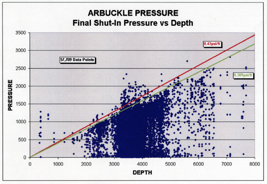
Whereas the Arbuckle is below hydrostatic-equilibrium pressure in Kansas (0.433 psi/ft), final shut-in pressures for thousands of Arbuckle wells exhibit a wide distribution, with a significant number exhibiting pressures less than half the regional hydrostatic pressure (Franseen et al., 2003; fig. 28). Although some low pressures result from poor reservoir permeability and lack of complete DST equilibration, initial and ongoing production from the reservoirs tested supports the interpretation that many low pressures reflect actual reservoir conditions and poor connection to the underlying aquifer, which is a significant departure from the commonly accepted paradigm of the presence of a strong bottom-water drive.
Figure 28--Final shut-in pressures for thousands of Arbuckle wells in Kansas. The pressures exhibit a wide distribution with a significant number exhibiting pressures less than half the regional hydrostatic pressure.
The variability in connection of upper Arbuckle strata to the underlying aquifer likely is due to a combination of structural, stratigraphic, karst, and other diagenetic controls. Detailed integrative studies can aid in understanding these controls on connectivity and provide predictive capabilities. An example is provided by Cansler and Carr (2001). They studied details of karst geomorphology of the upper Arbuckle surface at various scales, over the southern extent of the CKU (Barton, Ellsworth, Rice, and Stafford counties). In that study, the correspondence of sub-Pennsylvanian Arbuckle topography with Precambrian basement structural features was evaluated by superimposing structure contours of the top of the Precambrian surface, and interpreted lineaments from gravity and magnetic maps on the structure-contour map on the top of the Arbuckle (fig. 18). This analysis indicated that, although the sub-Pennsylvanian surface does not perfectly mimic the basement structure, when recognized, basement structure has a significant influence on alignment of karst and drainage features on the Arbuckle erosion surface.
Cansler and Carr (2001) recognized differences in oil productivity and drill stem test data from relatively recent (1960-present) infill wells between cockpit terrains and sapped plateau regions (figs. 29, 30). Relatively small, irregularly shaped fields that occur in mature cockpit landscapes experience relatively low cumulative production per well (typically 50,000-100,000 BO), whereas fields that occur on ground-water-sapped plateaus show significantly higher per well cumulative hydrocarbon recovery (200,000-300,000 BO). In general, infill wells located in areas dominated by cockpit karst experienced relatively high final shut-in pressures (1,000-1,200 psi) and infill wells located on sapped plateaus were characterized by significantly lower final shut-in pressures (250-750 psi). These differences in karst morphology, production, and pressures likely reflect differences in structural setting, relative contributions of through-going vertical fractures (impacting connectivity to the underlying aquifer), and stratigraphic elements, including types of facies.
Figure 29--Map (A) and block diagram (B) illustrating characteristic features of cockpit (polygonal) karst terrain. Cockpit karst landscapes are visually dominated by the residual hills that occur between a system of closed depressions, and these topographic divides can be polygonal in shape. Vertical exaggeration on block diagram is 10x.
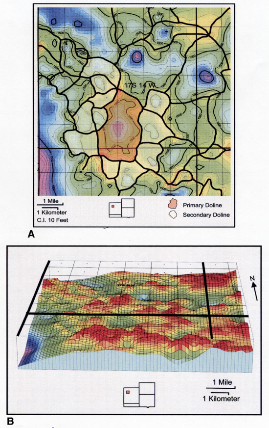
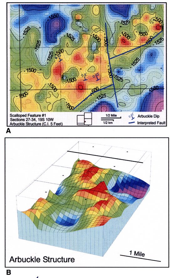
Figure 30--Map (A) and block diagram (B) illustrating characteristic features of sapped plateaus. The sapping processes produced scallops with theater-headed valley terminations on the northwest sides. Vertical exaggeration on block diagram is 10x.
Although some studies have utilized two-dimensional (2D) seismic data for study of the Arbuckle (e.g. Carr et al., 1994; Carr et al., 1995), detailed study of Arbuckle three-dimensional (3D) seismic data that exist in the private sector could provide valuable data and information on Arbuckle characteristics, including structural and stratigraphic elements.
Some recent efforts (e.g. Byrnes et al., 1999) have explored upscaling and integrating plug to well-scale petrophysics with detailed sedimentology to quantify the relative role of fracture, vug, and matrix properties in Arbuckle reservoirs. This integrated approach has implications for 1) understanding correlations between lithofacies and petrophysical properties; 2) developing a model to understand how core and DST permeabilities relate in laterally extensive cyclic carbonate strata (such as the Arbuckle); 3) developing a quantitative model for upscaling core permeability in laterally extensive cyclic carbonate strata; 4) providing insight on the potential for deeper Arbuckle traps; 5) information for determining when alternate production or IOR strategies, such as polymer modification or horizontal drilling may be warranted; and 6) developing an integrative approach to understanding geologic, core, log, and DST data.
Whereas good examples of wells where full integration can be performed are limited, initial results of integrated petrophysical studies of Arbuckle strata indicate that well production, particularly in sapped plateau-terrain reservoirs, can be explained by matrix-scale permeability (plug to full-diameter core) and variations in permeability between lithofacies. Although the open-hole productive interval in a well consists of interbedded reservoir and non-reservoir intervals, total flow represents the cumulative flow that would be predicted by the permeability-height (kh) of the total interval and primarily the permeability of the thin reservoir beds.
Reservoir-rock lithofacies, exhibiting porosities from 10 to 25% and permeabilities from 10 to 1,500 millidarcies, include laminated grainy algal boundstones and moldic packstone and grainstone. Non-reservoir rock lithofacies include mudstone, peloidal wackestone and packstone, muddy algal boundstone, and chert. In some cores, vugs locally enhance whole-core permeabilities up to 10 times. Where full-diameter core and drill-stem test permeabilities are not consistent, higher drill-stem permeabilities aid in identifying and quantifying fracture-related flow.
In unfractured strata, differences between core and DST permeabilities may be explained by differences in flow-model assumptions and data-averaging methods. Geometric mean permeabilities, which mathematically represent random regional distribution of the permeabilities averaged, do not seem to accurately represent the layered flow system. Arithmetic mean permeabilities, which represent an average of a parallel flow system, are more consistent with the conceptual flow model for the Arbuckle system and provide better correlation with DST-calculated permeabilities. Modeled permeabilities based on upscaled core and log data indicate that small-scale laterally persistent stratal packages exert significant control on flow properties of the entire Arbuckle section. Integration of lithologic, stratigraphic, and petrophysical data at the plug, whole-core, and drill-stem test scales allows separation of the relative contributions of fractures, vugs, and matrix properties to reservoir flow.
Work is still on-going for testing the upscaling and modeling concepts and methodology. Arithmetic averaging of permeabilities and the use of the permeability-porosity trend has provided a significantly better correlation between DST and smaller-scale permeabilities.
The various aspects of the recent and ongoing research on Arbuckle strata in Kansas are providing insight on Arbuckle reservoir character and directions for future research to improve the emerging picture of Arbuckle reservoir types. Arbuckle strata consist of complex stacks of reservoir and non-reservoir lithologies at various frequency and thickness scales. Knowing this, the Arbuckle in Kansas can be viewed as having three end-member reservoir architectures, representing fracture-, karst-, and matrix-dominated architectural systems, with numerous possible variations between these end-member architectures (Franseen et al., 2003; fig. 31). Notably, in all three architectures, lithofacies and stratal packaging of reservoir and non-reservoir strata exert a control on reservoir architecture, despite other processes that affect the rocks.
Figure 31--End-member Arbuckle reservoir types. A) Abundant fracturing of strata. Lithofacies control porosity and permeability within individual layers (beds), but fractures dominate overall permeability. B) Karst overprinting on lithofacies and fractures, resulting in complex porosity and permeability. Karst overprinting can vary laterally from insignificant to extensive. Even where extensively developed, karst processes can both enhance and destroy reservoir properties. C) Lithofacies control porosity and permeability, and laterally persistent stratal packages may exert significant control on flow properties.
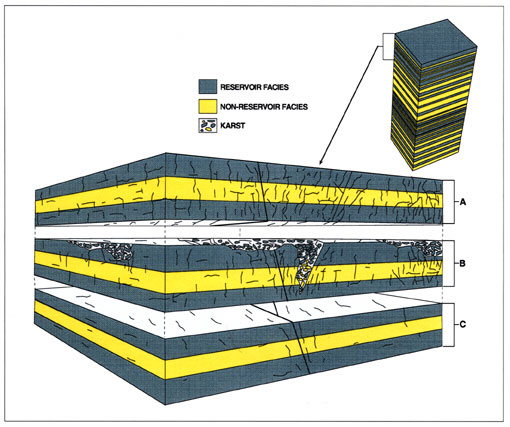
The first end-member type is dominated by fractures, possibly related to faults in structurally complex areas (fig. 31A). In this type of reservoir scenario, lithofacies control porosity and permeability within individual layers (beds), but fractures dominate overall permeability.
The second end-member type of reservoir is the classic conceptual reservoir model for Arbuckle strata in Kansas. In this scenario processes associated with karst overprint lithofacies and fractures, resulting in complex porosity and permeability (fig. 31B). However, karst overprinting can vary laterally from being extensive to insignificant. Also, even where extensively developed, karst processes can both enhance or destroy reservoir properties. For example, open fractures, caves, and vugs in reservoir facies near the unconformity may enhance permeability. However, open fractures and vugs in non-reservoir facies are likely to be insignificant in enhancing overall reservoir character. This emphasizes the importance of understanding which lithologies intersect the unconformity. Additionally, infilling of fractures and vugs with karst sediment and cement associated with karst can completely destroy reservoir properties, even in favorable reservoir facies.
The third end-member type of reservoir shows relatively little fracturing and karst overprinting (fig. 31C). In this reservoir type, lithofacies control porosity and permeability, and laterally persistent stratal packages may exert significant control on flow properties. These types of reservoirs may be significant, especially where karst overprinting is not extensive, in areas away from faults, in areas off structural highs, and stratigraphically deeper within the Arbuckle.
As in the past, the ongoing and future research and an increased understanding of Arbuckle Group strata in Kansas will be closely tied into petroleum industry practices, trends, needs, and economic factors. Improved reservoir characterization and IOR efforts could potentially lead to recovery of hundreds of millions of barrels of oil from Arbuckle reservoirs in Kansas.
Research included in this paper has been partially supported by two research grants from the University of Kansas Energy Research Center. Appreciation is extended to Rex Buchanan for reviewing an early version and to reviewers John E. Repetski and Paul J. Ramondetta who provided useful constructive comments. Marla Adkins-Heljeson is thanked for editorial assistance, and Jennifer Sims is thanked for graphics art support.
Prev Page--Characteristics || Next Page--References
Kansas Geological Survey
Web version Dec. 27, 2004
http://www.kgs.ku.edu/Current/2004/franseen/05_econ.html
email:webadmin@kgs.ku.edu