![]()
where f is frequency. Equation (7) was used to construct fig. 4, which shows the optimal vertical resolution for dipole antennas with a bandwidth equal to 1 ![]() 0.5 of the center frequency (e.g., f = 225-675 MHz for a 450-MHz antenna), a common GPR antenna design.
0.5 of the center frequency (e.g., f = 225-675 MHz for a 450-MHz antenna), a common GPR antenna design.
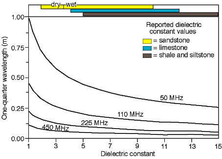
Fig. 4. Plot of dielectric constant versus maximum vertical imaging resolution for bistatic, dipole antennas with a bandwidth equal to 1 ± 0.5 of their center frequency. Typical dielectric-constant ranges for sedimentary rocks are shown as bars. The dielectric constant values are a summary of values given in Annan (1996), Daniels (1996), and Schon (1996).
Spatial resolution is determined by the area of the region illuminated by a GPR antenna, often referred to as the Fresnel zone or antenna footprint. For bistatic dipole antennas, the area of the antenna footprint can be approximated using the relationships:
![]()
and
![]()
where A is the radius of the Fresnel zone parallel to the long axis at depth z(d), B is the radius perpendicular to the long axis at depth z(d), z(d) is the depth of the Fresnel zone in the subsurface, and z(0) is the antenna elevation relative to ground level (Annan, 1996) (fig. 5). Equations (8) and (9) and fig. 5 indicate that GPR patterns become more focused with increasing dielectric constant, resulting in greater spatial resolution. The equations can be used to determine antenna frequencies suitable for imaging subsurface targets with known spatial dimensions.
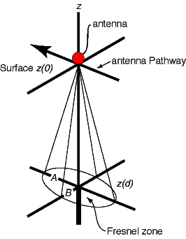
Fig. 5. Approximate GPR-antenna footprint (Fresnel zone) for bistatic, dipole antennas (adapted from Annan, 1996). This footprint is calculated using Equations (8) and (9). A = long radius; B = short radius; z = elevation, where z(0) is the surface elevation and z(d) is the depth of the Fresnel zone.
Kansas Geological Survey
Web version December 3, 2001
http://www.kgs.ku.edu/Current/2001/martinez/martinez5.html
email:lbrosius@kgs.ku.edu