Kansas Geological Survey, Current Research in Earth Sciences, Bulletin 244,
part 3
The Relationship Between Geology and Landslide Hazards of Atchison, Kansas, and Vicinity--Fig. 15
![]()
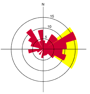
Fig. 15. Rose diagram showing the slope lines for the recent landslides. Two maxima are observed in the data. The first is from northeast to southeast and is related to the bluffs of the Missouri River (yellow area in figure). The second is to the northwest and may be related to ground-water flow.