Kansas Geological Survey, Current Research in Earth Sciences, Bulletin 244, part 1
Prev Page--Pteranodon, cont. || Next Page--Conclusions
![]()
![]()
![]()
Kansas Geological Survey, Current Research in Earth Sciences, Bulletin 244, part 1
Prev Page--Pteranodon, cont. ||
Next Page--Conclusions
![]()
The stratigraphic distribution shows that skulls with upright occiputs occurred only in the lower part of the Smoky Hill Chalk Member and that skulls with reclined occiputs occurred only in the upper part of the Smoky Hill Chalk Member. Because the two morphs do not co-occur, they could be early and late forms of a single evolving species or lineage, but the hypothesis is falsified because the polarity of the crest shape change is the opposite of that which was expected. The two morphs are probably chronospecies of an anagenetically evolving single species lineage that continued throughout the time of deposition of the Smoky Hill Chalk Member.
This study shows that it is possible to determine the stratigraphic positions of specimens from the Smoky Hill Chalk Member from locality data even if they were collected more than 100 years ago. When applied to even a small number of specimens, the procedure can have the power to reject hypotheses.
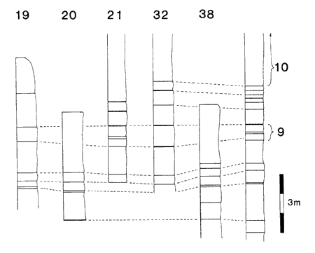
While determining the stratigraphic positions of other specimens not discussed in this paper, I visited many other localities and measured stratigraphic columns. Additional measured sections covering much of Logan County and part of Gove County are included in figs. 2, 5, 6, and 7. The pattern of the exposures is interesting. In the northwestern part of the exposures in Gove County (fig. 2) and much of Logan County (figs. 5 and 6) as well as in western Graham County (fig. 3), the interval between Marker Units 15 and 20 is almost exclusively exposed. The interval between Marker Units 10 and 15 is exposed in places in eastern Logan and western Gove counties (Locality 18, Hattin's localities 22 and 23), but the caprock (Marker Unit 10) and the chalk below appear to be more widely exposed in those areas (fig. 7). This may be a result of a bias on my part toward outcrops that are larger and easier to measure; other parts of the Smoky Hill Chalk Member may be extensively exposed but in outcrops that are small in area or thickness and difficult to measure. On the other hand, it is possible that the chalk between Marker Units 10 and 15 and above Marker Unit 20 erodes more easily and is not widely exposed. More study of this question is needed. The apparently biased distribution of exposures suggests that most of the fossil vertebrates collected from the Smoky Hill Chalk Member came from a rather restricted stratigraphic interval between Marker Units 15 and 20. This may have important implications for future studies of fossil vertebrates from the Smoky Hill Chalk Member.
Fig. 5--Correlation of stratigraphic columns of localities along the Smoky Hill River in Logan County, Kansas. Black bands indicate bentonites, seams, and in a few instances a change in lithology; white indicates chalk. Localities are numbered across the top and arranged in order from west to east. The unnumbered column at right is the composite stratigraphic column from Hattin (1982). Hattin's marker units are identified by the numbers at right, and Russell's (1929) marker unit H is also indicated. The relative vertical position of different stratigraphic columns in the figure is not significant.
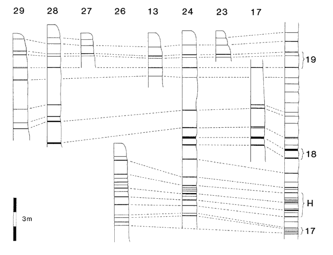
Fig. 6--Correlation of stratigraphic columns of localities along Twin Butte Creek in Logan County, Kansas. Black bands indicate bentonites, seams, and in a few instances a change in lithology; white indicates chalk. Localities are numbered across the top and arranged in order from west to east. The unnumbered column at right is the composite stratigraphic column from Hattin (1982). Hattin's marker units are identified by the numbers at right, and Russell's (1929) marker unit H is also indicated. The relative vertical position of different stratigraphic columns in the figure is not significant.
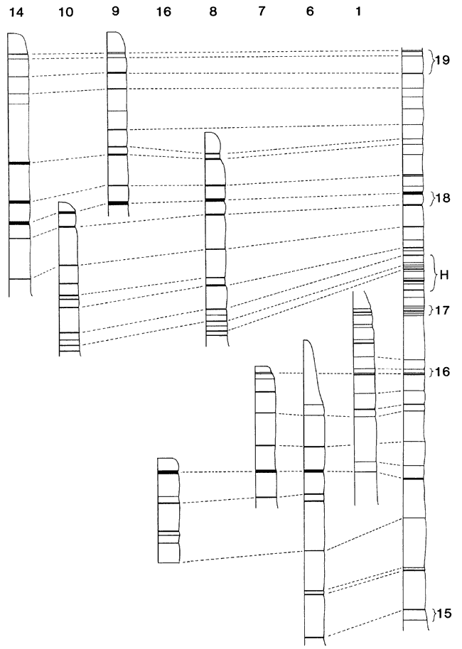
Fig. 7--Correlation of stratigraphic columns of localities in southeastern Logan and southwestern Gove counties, Kansas. Black bands indicate bentonites, seams, and in a few instances a change in lithology; white indicates chalk. Localities are numbered across the top and arranged in order from west to east. The unnumbered column at right is the composite stratigraphic column from Hattin (1982). Hattin's marker units are identified by the numbers at right. The relative vertical position of different stratigraphic columns in the figure is not significant.
Prev Page--Pteranodon, cont. || Next Page--Conclusions
Kansas Geological Survey
Web version September 28, 2000
http://www.kgs.ku.edu/Current/2000/bennett/bennett5.html
email:webadmin@kgs.ku.edu