Soil series, as depicted in county soil survey reports, proved to be excellent indicators for both residual and alluvial chert gravel deposits (e.g., Penner et al., 1975; Swanson and Googins, 1977; Neill, 1981). The Florence series is developed in residual chert weathered from limestones on Flint Hills uplands (fig. 5). Chert in these soils has not been transported by streams, although some mass movement may have taken place on slopes. The Olpe series is formed on alluvial chert gravel on hilltops and high terraces (fig. 6). Chert in these soils was transported by streams and deposited in channels as various kinds of bars, dunes, and riffles. Chert gravel may be interbedded with finer alluvial sediments.
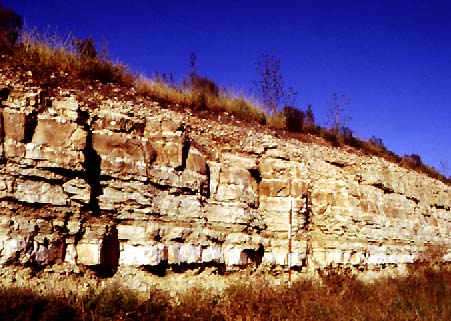
Fig. 5. Exposure of Florence Limestone in eastern Butler County. Light gray beds and nodules of chert weather out at the surface and accumulate as a residual lag deposit on Flint Hills uplands. Scale pole marked in feet.
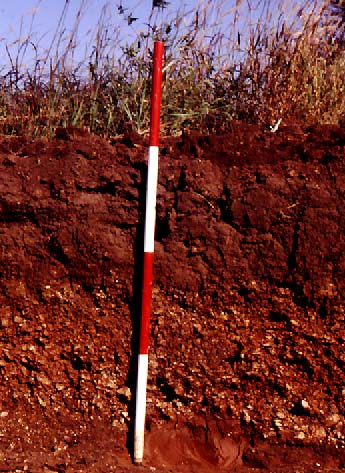
Fig. 6. Profile in Olpe soil in hilltop position on drainage divide between the Little Walnut River and Walnut River valleys, southern Butler County. Note dark reddish-brown color of B horizons in lower portion of profile. Scale pole marked in feet.
In nearly all cases, field observation verified that alluvial chert gravel is present as depicted on soil survey reports. Very few instances were found in which Olpe soil proved to be residual chert, rather than alluvial deposits. In a few cases, thin deposits of alluvial chert were discovered that are not identified as Olpe soil on the county reports. Other than these few exceptions, the Olpe soil is a regionally reliable indicator for alluvial chert gravel deposits in the uplands of eastern Kansas.
![]()
Kansas Geological Survey
Web version March 18, 1998
http://www.kgs.ku.edu/Current/1997/aber/aber5.html
email:lbrosius@kgs.ku.edu